36562 Preisdatenbank Los(e) gefunden, die Ihrer Suche entsprechen
36562 Lose gefunden, die zu Ihrer Suche passen. Abonnieren Sie die Preisdatenbank, um sofortigen Zugriff auf alle Dienstleistungen der Preisdatenbank zu haben.
Preisdatenbank abonnieren- Liste
- Galerie
-
36562 Los(e)/Seite

![[EUROPE -- NETHERLANDS] -- ORTELIUS, Abraham (1527-1598). Belgii Veteris Typus. [Antwerp], 1584.Engraved map with later hand-](https://cdn.globalauctionplatform.com/14116182-6b38-4f40-9d98-ad0b011c8511/669d5761-9472-4f25-8cbb-ad0b01453ae4/468x382.jpg)
Los 245
[EUROPE -- NETHERLANDS] -- ORTELIUS, Abraham (1527-1598). Belgii Veteris Typus. [Antwerp], 1584.Engraved map with later hand-coloring, 298 x 506 mm sight, matted and framed (unexamined out of frame). 4 cartouches, compass rose, Latin text verso. Provenance: Schoonheim B. V. (gallery label on back of frame). Depicting the historic part of Belgium, and showing the English Channel and part of Britain.For condition inquiries please contact Gretchen Hause at gretchenhause@hindmanauctions.com
![[PARIS] -- DE LISLE, Guillaume (1675-1726). Le Plan de Paris, ses Faubourgs et ses Environs|Platte Grond van Parys, zyn Voorb](https://cdn.globalauctionplatform.com/14116182-6b38-4f40-9d98-ad0b011c8511/228ac3ef-fd38-4cd4-a084-ad0b0145520c/468x382.jpg)
Los 247
[PARIS] -- DE LISLE, Guillaume (1675-1726). Le Plan de Paris, ses Faubourgs et ses Environs|Platte Grond van Parys, zyn Voorburgen en Omleggende Plaatse. Amsterdam: Covens & Mortier, ca 1730.Engraved map of Paris on two sheets with later hand-coloring, 582 x 765 mm sight, matted and framed (unexamined out of frame). Two decorative cartouches, the French Royal Coat of Arms, compass rose.Based on an earlier map by Nicolas de Fer, and including the Louvre Castle, Notre Dame, Place de Vosges, and Luxembourg Gardens.Property from the Collection of Steven Huffines, San Francisco, CaliforniaFor condition inquiries please contact Gretchen Hause at gretchenhause@hindmanauctions.com
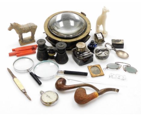
![An Egyptian Revival ashtray, cast with the head of pharaoh; a World War Two style marching compass, [2]](https://cdn.globalauctionplatform.com/e6326352-f254-49ae-94c0-ad1200d2d26c/877ae980-6c33-45d4-bf9f-ad2101321150/468x382.jpg)
![Blaeu (Willem Janszoon & Johannes). Theatrum orbis terrarum, sive Atlas novus, pars quarta [England and Wales], Amsterdam](https://cdn.globalauctionplatform.com/773a2f63-986c-4cc6-9db3-ad1200b50a92/4b21ba0b-5597-433d-8693-ad13012561d1/468x382.jpg)
Los 334
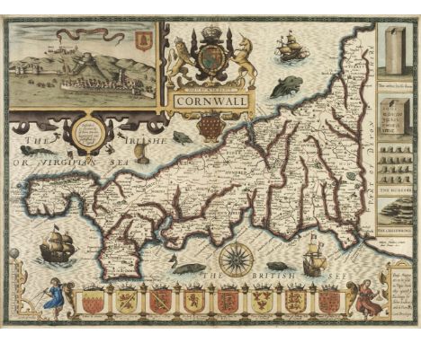
Blaeu (Willem Janszoon & Johannes). Theatrum orbis terrarum, sive Atlas novus, pars quarta [England and Wales], Amsterdam: apud Johannem Blaeu, 1648, [6] 394 [1] pp., signatures *1 2*2 A-7B2 (7B2=list of maps), engraved architectonic title-page and 58 engraved maps (counted in pagination and register, all folding except for the Isle of Man; Bedfordshire and Buckinghamshire both on the one sheet), all hand-coloured (title-page heightened with gold), 4 engraved vignettes in the text (also hand-coloured and depicting henges, burial chambers and mausolea), woodcut initials, tailpieces and other illustrations, mounted on guards throughout (evidence of skilful removal and reinsertion), a few worm-tracks to foot of stubs from front of volume to signature 3M (never affecting maps or text), a number of maps lightly browned along central fold, small shallow damp-stains to margins of first and last few leaves, a few other trivial marks (generally in very good condition with wide margins), all edges gilt, contemporary Dutch full vellum gilt, retaining 3 of 4 green linen ties, yapp edges, a few minor scuffs and marks, small section of loss to top edge of rear board, folio (51.6 x 30.8 cm)Qty: (1)NOTESKoeman Bl 44 (volume 1 pp. 178-80); Skelton 42; cf. Chubb LIX-LXII (LXII is an uncoloured copy of the 1648 edition). Second edition in Latin of this 'very fine atlas of the English counties compiled, mainly from the maps of John Speed' (Chubb). A total of six volumes were published. The present volume, depicting England and Wales, first appeared in 1645, and was reissued in 1646. For this 1648 edition the text was reset and the maps of Cornwall, Sussex and Leicestershire have the cardinal compass points added in the border; otherwise 'the plates from which the maps were reprinted remained unaltered throughout all editions of this volume' (Skelton). There are three general maps ('Magnae Britanniae et Hiberniae tabula', 'Britannia' and 'Anglia Regnum') and maps of the Isle of Man, Holy Island and the Channel Islands in addition to those of counties.
Los 457
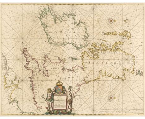
British Isles. Jansson (Jan), Pascaart vant Canaal tusschen Engelant en Vrancryck, alsmede geheel Ierlant en Schotlant..., Amsterdam, circa 1650, engraved chart, orientated to the west with contemporary outline colouring, compass rose and numerous rhumb lines, decorative allegorical cartouche, slight staining and text show through, 435 x 555 mm, French text on versoQty: (1)NOTESOriginally published in "Atlantis Majoris Quinta Pars Orbem Maritimum".
Los 464
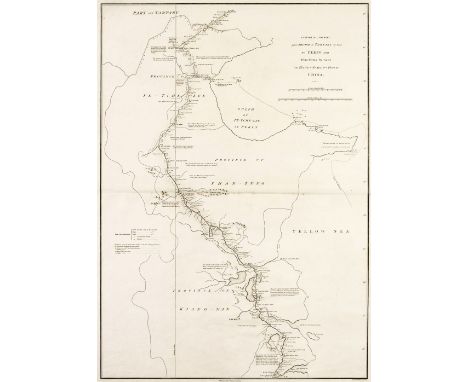
China. Four maps from Sir George Staunton's " An Authentic Account of an Embassy from the King of Great Britain to the Emperor of China..., A Sketch of a Journey from Zhe-Hol in Tartary by land to Pekin and thence by Water to Hang-Tchoo-Foo in China, A Sketch by Compass of the Coast of the Promontory of Shan-Tung with the Tracks of the Ships..., to the Strait of Mi-A-Tau, Sketch of a Journey from Hang-Tchoo-Foo to Quang-Tchoo-Foo or Canton in China [and] A Chart of the Islands to the Southward of Tchu-San on the Eastern Coast of China, 1797, together 4 uncoloured engraved maps, old folds, each approximately 665 x 485 mm, together with View of the City of Ten-Tchoo-Foo from the Anchorage of the Hindostan in the Strait of Mi-A-Tau bearing Southwest, 1797, an uncoloured engraved prospect of the city and two horizon profiles on one sheet (as published), slight creasing, 530 x 750 mmQty: (5)
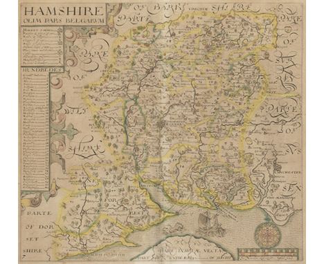
Los 484
* Hampshire. Norden (J. & Hole G.), Hamshire olim pars Belgarum, circa 1637, hand-coloured engraved map, toned overall, 295 x 325 mm, mounted, framed and glazed, together with Greenwood (C. & J.). Map of the County of Southampton from an Actual Survey made in the years 1825 & 1826..., 4th July 1829, engraved map with contemporary outline colouring, calligraphic cartouche, compass rose, table of explanation, list of the Hundreds and an uncoloured vignette of Winchester Cathedral, 585 x 700 mm, mounted, framed and glazed, with Cary (John). A New Map of Hampshire Divided into Hundreds, Exhibiting its Roads, Rivers, Parks &c. Sept. 28th 1801, engraved map with contemporary hand colouring, 550 x 485 mm, mounted, framed and glazed, plus Moll (Herman). Hamp Shire, [1724 or later], uncoloured engraved map decorated with antiquities in the vertical margins, slight overall toning, 195 x 315 mm, mounted, framed and glazed, and three other maps of Hampshire by Cary & Moule, various sizes and conditionQty: (7)
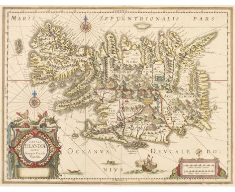
Los 490
Iceland. Jansson (Jan), Tabula Islandiae Auctore Georgio Carolo Flandro, circa 1650, engraved map with contemporary hand-colouring, large decorative cartouche and mileage scale, compass rose and numerous rhumb lines, central fold partially split and repaired on verso, 380 x 500 mm, French text on versoQty: (1)
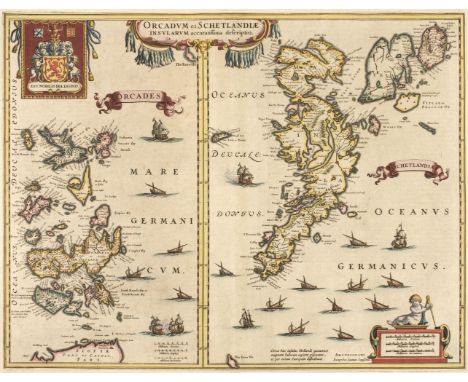
Los 515
Orkney Islands. Jansson (Jan), Orcadum et Schetlandiae Insularum accuratissima descriptio, Amsterdam, circa 1640, two engraved maps on one sheet (as published) both with contemporary hand-colouring, 380 x 490 mm, French text on verso, together with Collins (Capt. Greenville). The Cheife Harbours in the Islands of Orkney..., [1688 or later], hand-coloured engraved chart, two inset maps of Deer Sound and Stromness and five inset horizon profiles, compass rose and numerous rhumb lines, closed repaired tears affecting image, 445x 565 mmQty: (2)
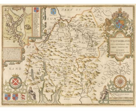
Los 544
Westmorland. Speed (John), The Countie Westmorland and Kendale the Cheif Towne Described, Thomas Bassett & Richard Chiswell [1676], hand-coloured engraved map, an inset town plan of Kendal, large strapwork cartouche, compass rose and mileage scale, slight mount staining, 385 x 510 mm, English text on versoQty: (1)
Los 624
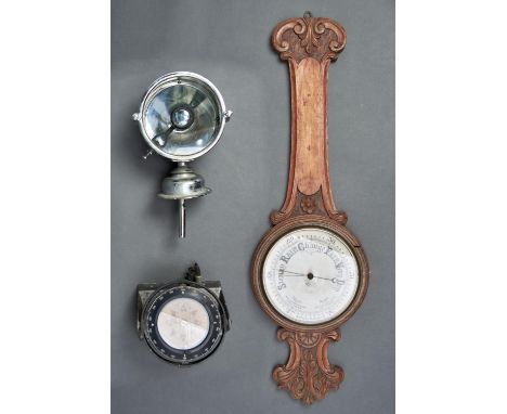
Sailing. A Sharp & Co Ltd Autopilot compass, 15cm diam, 16.5cm h, a chromium plated ship's lamp with concave reflector, the sprung bulb mechanism with engraved and enamelled stylised boat bearing plaque, a type 1247 No S70.1709 80 watts, lamp 18cm diam, 35cm h, a late Victorian oak wheel barometer, the cream dial engraved in black, foliate carved case, 84cm h (3) Compass wear consistent with age; Lamp with faults to concave reflector and some degrading to chromium plating, other wear; aneroid barometer lacking thermometer, other extensive wear
Los 798
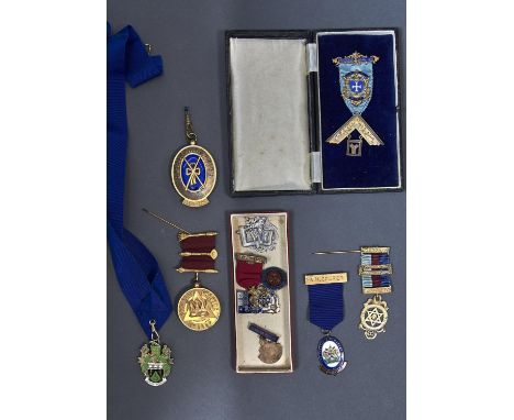
Masonic interest. A silver gilt and blue engine turned enamel Nottinghamshire assistant medallion, 6.5cm h, by G Kenning & Son, Birmingham 1939; another: Annesley Chapter No. 1435 with device and crown, the reverse inscribed Presented to E. Comp. E. Cooper by the companions for his able services as mez, 1950, by Fattorini and Sons, Birmingham 1951, a Bentinck Lodge badge and masonic device, silver gilt badge no. 3416 hung masonic devices, dated 1941-42, 9.5cm h overall, by G Kenning & Son, 1947, cased, another silver gilt and enamel badge: Royal Masonic Benevolent Institution, 1932, stewards badge by G Kenning & Son, London 1931, another silver coloured metal masonic badge, the striped ribbon with silver gilt clasps, a silver and enamel mayoral badge of office, Birmingham, modern, a silver masonic compass and square, 3.5cm h, unmarked, a silver foliate engraved medallion with engraved shield shaped cartouche and banner by William Hair Haseler, 4cm h; four other badges: British Sailor's Society, Notts County and district bowling association, the institute of marketing past branch chairman and national savings 20 years service badge Generally good, some with signs of wear, silver medallion and compass and set polished, otherwise generally good and commensurate with age
Los 142
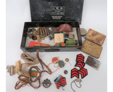
WW2 Soldier's Souvenir Boxall relating to "271529 L Dowty". Including pair of fibre dog tags ... Silver wrist ID tag ... Civilian miniature compass ... White metal, KC AAC cap badge ... Southern Eire Civil Defence lapel badge ... 2 x Anti Gas No 2 Ointment tins. Complete ... 2 x Anti Dimming MKV Outfit .. Various buttons and badges ... Selection of NAAFI tokens. All contained in an ARP first aid tin case.
Los 380
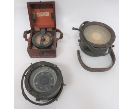
Three Various Large Compassesconsisting medium landing compass Ref 6B/0.34. Grey painted finish. The top with lift up sights. Complete in its wooden transit box dated "1939" ... Steel and brass type 1040 A compass. Complete with fixing gimbal ... Similar smaller, grey painted example. Gimbal present but loose.
Los 388
WW1 RFC / Cavalry British Army Issue Map BoardThis pattern issued to the RFC, RNAS and mounted Officers of the Army. The board is with two rolls to accommodate a linen map. Also fitted with compass. Complete with leather strap. Maker's stamp of ?Astow & Mander Ltd? Some service wear, leather strap supple.
Los 432
WW2 RAF Aircraft P4A Compassgrey painted body with plated plaque with crowned "AM" and "Ref 6A/745". Blackened, top glazed mount marked "Type P4A". Compass fluid absent. Contained in its wooden transit box, dated "1940". Together with a small ship's compass with brass, pull over hood. 2 items.
Los 2554
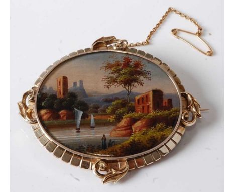
A yellow metal mourning brooch depicting a hand-painted river landscape, within a fringed border with scrollwork detail at compass points and a section to the back with five lots of woven hair, having hook clasp and safety chain, brooch dimensions 64 x 55mm, gross weight 31.2g, stamped and tested as 9ct
Los 2594
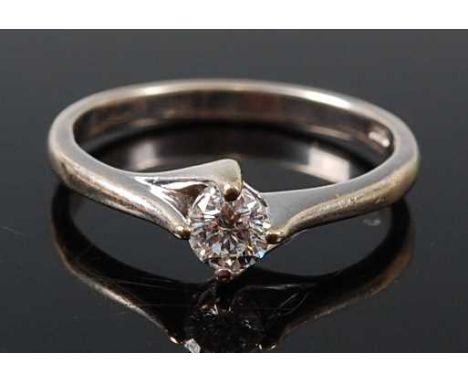
A 9ct white gold diamond single stone ring, featuring a round brilliant cut diamond in a a four-claw compass setting, diamond dimensions approx 4.1 x 2.75mm, weight estimated as 0.28 carats, assessed mounted colour I to J and clarity SI2 to I1, size N, gross weight 2.6g, hallmarked 9ct, London, no date, sponsor AT Ltd
Los 760
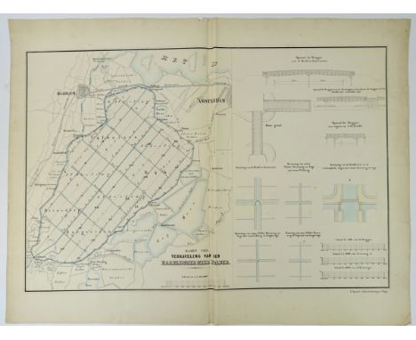
LOW COUNTRIES -- HAARLEMMERMEER -- "KAART VIII. Verkaveling van den Haarlemmer Meer Polder". 's-Grav., E. Spanier, n.d. (between 1852-60). Lithogr. map divided in 2 sections: left the Haarlemmermeer and right hydraulic details, cold. by hand w. blue colour wash. 545 x 722 mm. (4 small tears on central fold, but without loss of image). -- Added: "KAART VAN DE GEMEENTE HAARLEMMERMEER" (&) "STAAT DER VERKOCHTE PERCEELEN". Rott., Van Gogh & Oldenzeel, 1855. Plain lithogr. map and list of names of buyers. 515 x 418 mm. -- And: "AFBEELDINGE VAN RHYNLANDS WATERSTAAT ten Opzigte van 't Vergrooten der Haarlemmer of Leydse Meer (…) volgens Meetinge A° 1739 en 1740 gedaan bij mij (…) M. Bolstra". (1746). Engr. map w. title cartouche, compass rose and scale indicator. 548 x 629 mm. (Margins a bit frayed/dam.). -- And 3 o. in relation to the Haarlemmermeer. (7).
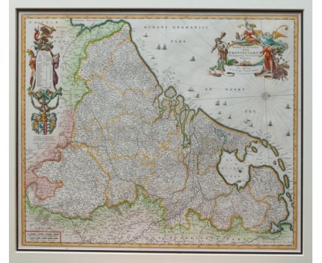
Los 784
LOW COUNTRIES -- "NOVISSIMA & ACCURATISSIMA XVII Provinciarum Germaniæ Inferioris Delineatio". (Amst.), N. Visscher, n.d. (between 1656 and 1663). Fine cold. engr. map by A. Deur w. 2 fine large cartouches, compass rose and scale indicator. 475 x 570 mm. Framed, glazed and under (double) passepartout. NOTE:Uninspected out of frame. Van der Heijden 126 (first state).
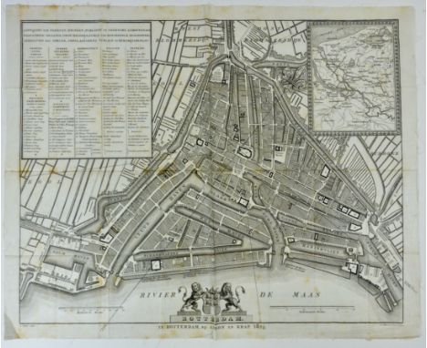
Los 790
LOW COUNTRIES -- ROTTERDAM -- "ROTTERDAM". Rott., Arbon & Krap, 1824. Engr. plan of the city by D. Sluyter and C. v. Baarsel & Son, printed on silk (!). 430 x 535 mm. W. 2 scale indicators, inset map w. compass needle pointing North, and index in 3 languages, numbered 1-84. Folded in 32 sections. (Some mild foxing on one of the central folds, but in very fine condition). NOTE:Roterodamum Illustratum 55. Rare.
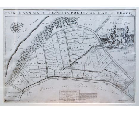
Los 794
LOW COUNTRIES -- ZEELAND -- "CAARTE van Sinte Cornelis Polder anders de Quacq". (Amst., 1701). Plain etched map by J. Luyken and I. Stemmers after A. Steyaart. c. 500 x 705 mm. W. large cartouche and compass rose. Recently framed, glazed and under passepartout. NOTE:From: VOORNE CAART-BOECK Van alle Dorpen, en Polders gelegen Inden Lande van Oost, ende West Voorne, Mitsg. Over Flacqueé (…). N.pl., 1701. Uninspected out of frame, but in perfect condition. - Donkersloot-de Vrij, 247; Van Eeghen/v.d. Kellen, 370; Landwehr, RdeH, 97; Van Nierop, RdeH, 1701.08.
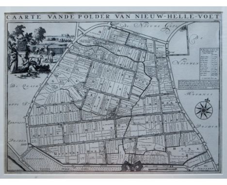
Los 795
LOW COUNTRIES -- ZEELAND -- "CAARTE vande Polder van Nieuw-Hellevoet". (Amst., 1701). Plain etched map by J. Luyken and I. Stemmers after A. Steyaart. c. 500 x 705 mm. W. large cartouche and compass rose. Recently framed, glazed and under passepartout. NOTE:From: VOORNE CAART-BOECK Van alle Dorpen, en Polders gelegen Inden Lande van Oost, ende West Voorne, Mitsg. Over Flacqueé (…). N.pl., 1701. Uninspected out of frame, but in perfect condition. - Donkersloot-de Vrij, 247; Van Eeghen/v.d. Kellen, 370; Landwehr, RdeH, 97; Van Nierop, RdeH, 1701.08.
Los 796
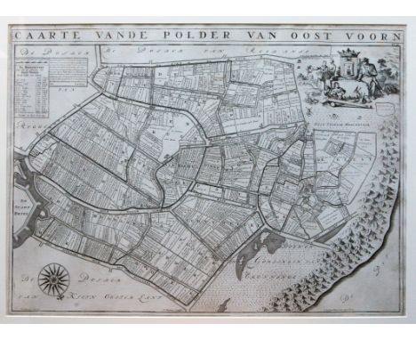
LOW COUNTRIES -- ZEELAND -- "CAARTE vande Polder van Oost Voorn". (Amst., 1701). Plain etched map by J. Luyken and I. Stemmers after A. Steyaart. c. 500 x 705 mm. W. large cartouche and compass rose. Recently framed, glazed and under passepartout. NOTE:From: VOORNE CAART-BOECK Van alle Dorpen, en Polders gelegen Inden Lande van Oost, ende West Voorne, Mitsg. Over Flacqueé (…). N.pl., 1701. Uninspected out of frame, but in perfect condition. - Donkersloot-de Vrij, 247; Van Eeghen/v.d. Kellen, 370; Landwehr, RdeH, 97; Van Nierop, RdeH, 1701.08.
Los 799
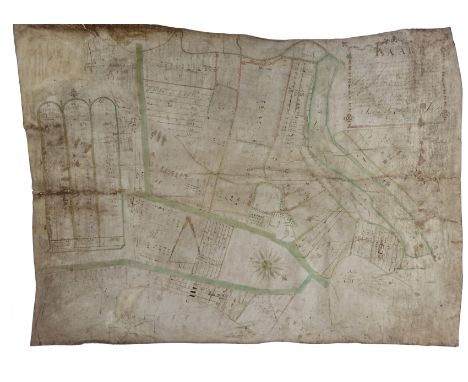
LOW COUNTRIES -- ZEELAND -- "KAART St. JAN of NIEUVLIET". Dated 1779. Large cold. manuscript map by Willem Pleijte Wzn. of the polders around Nieuwvliet, drawn on vellum, w. compass rose and scale indicator. c. 735 x c. 1000 mm. (Image (a bit) faded, but in good condition). NOTE:Nieuwvliet has always been a domain. The first lord was Jan Adornis, a Bruges merchant who in 1527 diked the Sint Janspolder, a polder in the 'Zwarte Gat' between the 'Eiland van Groede' and the 'Eiland van Cadzand'. He founded the high lordship, in which the older lords of 'Nieuwvliet', 'Sint-Pieter' and 'Mettenije' were united. In 1529 these united domains were recognized by Emperor Charles V. The three former domains were represented in the coat of arms of Nieuwvliet by three crescent moons.
Los 886
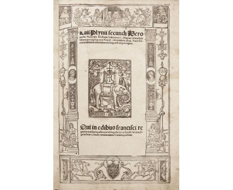
PLINIUS SECUNDUS. Naturalis hystoriae libri xxxvii. Par., N. de Pratis for Fr. Regnault, (1514). (20), 257 lvs. W. ti. printed within woodcut border incorporating fine woodcut printer's device with elephant. Fol. Cont. blind tooled h. pigskin over wooden brds. w. raised bands and clasps. (Some small rep. to spine, sev. tiny wormholes, margins stained in places, some minor foxing, with several marg. annot in an old hand and a drawing of classical compass winds on blank v° of leaf cc1). NOTE:Pliny's work, containing all that was known in ancient Roman times concerning mathematics, physics, cosmography, astronomy, geography, anthopology, physiology, medicine, zoology, agriculture, botany, mineralogy, commerce, and the history of art, remained the major source of knowledge throughout the Middle Ages. It was first printed in 1469 by Johannes de Spira of Venice. - Reprint of the first Paris edition of 1511, edited by Nicolas Maillard. (Collation: aa6 bb8 cc6 c-z8 &8 A-I8 K6 L8). - Adams P1553; Schweiger I, 785.
Los 407
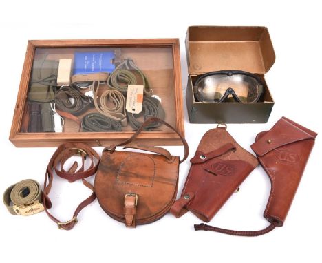
A US leather holster for automatic pistol (1911 Colt ?), marked “Rock Island Arsenal W.T.G”, and a similar holster for service revolver, both embossed with “US” in oval, New Condition; 4 original webbing slings for M1 carbine; a reproduction M1 carbine sling; a leather rifle sling; a webbing US Air Force belt with brass buckle; a British cavalry leather pouch for spare horse shoe; a 1960s wrist compass, and 6 other various items, together with a glazed wooden display case, 16" x 12" x 1" deep, and a pair of M1944 goggles in their carton with spare tinted lenses. Average GC £60-80
Los 93
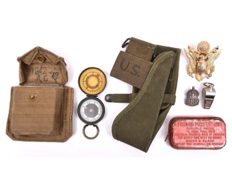
A WWI period (?) blackened brass cased non prismatic compass, “The Magnapole”, by “Short & Mason Ltd, Makers, London”, marked “Patent No 22598” (black finish worn); a WWII webbing compass pouch, dated 1942, with brass belt loops; an American “US Govt. First Aid Packet, Carlisle Model”, in sealed tin; a modern “Sterling Standard” US Army cap badge; a silver ARP lapel badge; a whistle; and another webbing item. Average GC (7) £50-60
Los 95
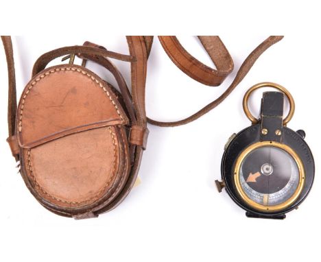
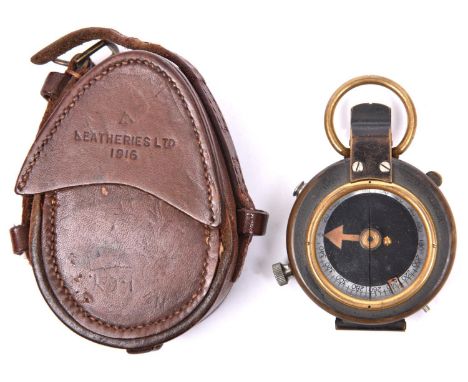
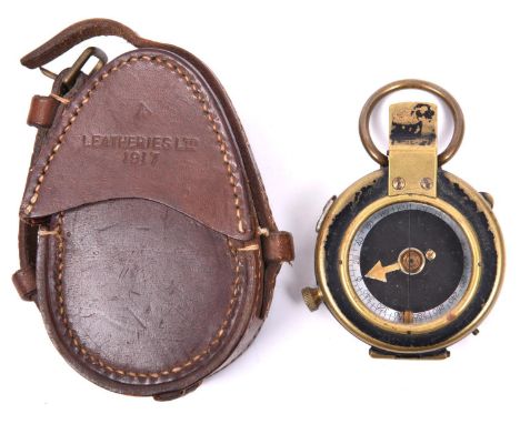
A WWI prismatic marching compass by Short & Mason Ltd, London, number 42735, marked with broad arrow between “AE” and dated “1916”, the front marked “Vernier’s Pattern VII”, with MOP dial, in its leather case stamped with broad arrow and “Leatheries Ltd 1916”. GC (leather stitching slightly loose). £60-80
Los 96
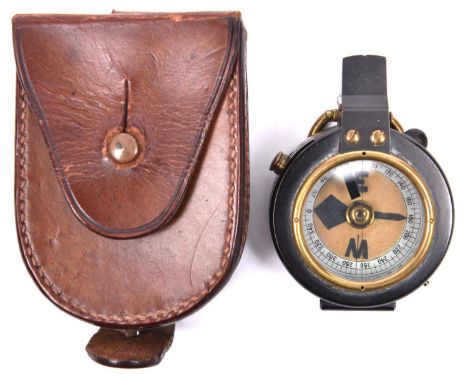
A WWI prismatic marching compass, by “F-L”, number 77715, bearing broad arrow and date “1917”, the front marked “Vernier’s Pattern VIII”, with MOP dial, in its leather case stamped “French & Son Ltd, London” and with broad arrow, impressed with the owner’s name “J H Gibson”. GC (some wear to black finish on the compass) £60-80
Los 98
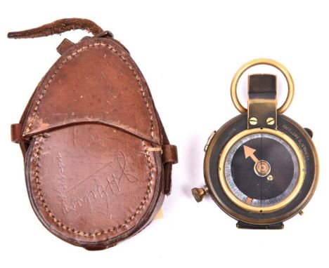
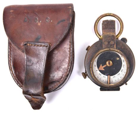
A WWI officer’s private purchase prismatic marching compass, unmarked apart from the owner’s name engraved around the rim on the back “A.C. Corbetta Norfolk Regt”, with white dial, in its leather case with belt loop, the flap stamped with initials “A.C.C”. GC (some wear to compass exterior) £60-120
Los 100
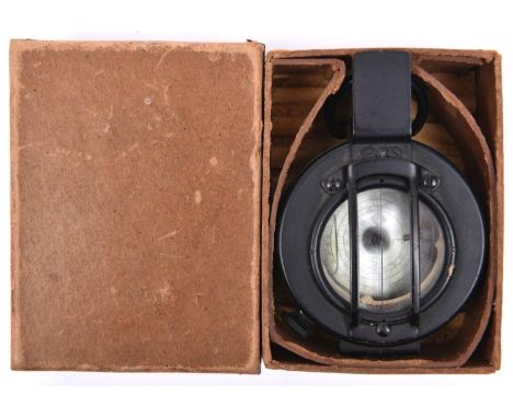
A WWII liquid filled prismatic marching compass, by “T.G. Co. Ltd, London”, number B4313, marked “1939 MkIII”, with glass guard and matt black finish, in unissued condition, in its stout card box with metal reinforced corners (the compass appears not to work as the dial is not level). £50-60
Los 101
A WWII liquid filled prismatic marching compass, by T.G. Co Ltd, London”, number B119478, marked “1941 Mk III”, GC (some wear); also a brown bakelite US Army Taylor Model liquid filled wrist compass, unissued, in its stout card box with leather wrist strap. GC (the box slightly worn). (2) £60-80
Los 154
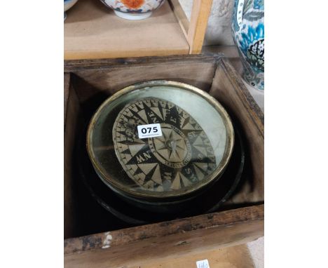
A Nairne & Blunt boxed compass, with a silvered dial, 12.5cm diameter a lacquered brass instrument, possibly a barometer, by Bourdan & Richards, 13cm diameter, a modern reproduction brass compass,9cm diameter, boxed and a case of cutters, 22cm long (4) Provenance: From the collection of the late Tony Saunders of BedfordCondition report: 1. Case worn and split.2. Not tested.3. No obvious major faults.4. Case worn.
-
36562 Los(e)/Seite