36562 Preisdatenbank Los(e) gefunden, die Ihrer Suche entsprechen
36562 Lose gefunden, die zu Ihrer Suche passen. Abonnieren Sie die Preisdatenbank, um sofortigen Zugriff auf alle Dienstleistungen der Preisdatenbank zu haben.
Preisdatenbank abonnieren- Liste
- Galerie
-
36562 Los(e)/Seite


Los 191
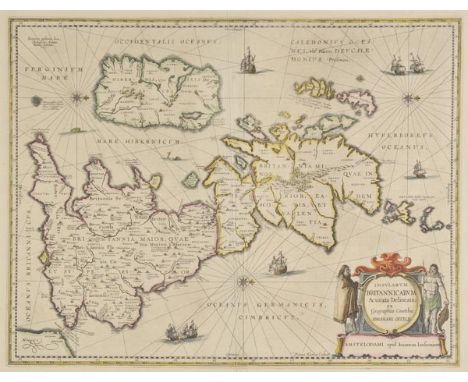
British Isles. Jansson (Jan), Insularum Britannicarum Acurata Delineatio ex Geographicis Conatibus Abrahami Ortelii, published Amsterdam, circa 1650, engraved map by Pieter van den Keere after Abraham Ortelius, contemporary outline colouring, orientated to the west, large decorative cartouche, compass rose and numerous rhumb lines, central fold strengthened on verso, 395 x 515 mm, French text on verso, mounted (1)
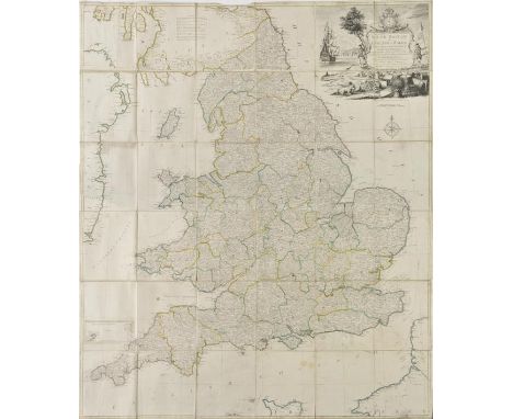
Los 209
England & Wales. Kitchin (Thomas), South Britain or England & Wales, Drawn from several surveys &c. on a new projection corrected from astronomical observations & the places marked where the observat.ns were made, 1769, engraved map with contemporary outline colouring, sectionalised and laid on linen, inset map of the Scilly Isles, large uncoloured decorative cartouche, compass rose and table of remarks, slight dust soiling and fraying to margins, ink manuscript ownership inscription (dated 1776 & 1811) to verso, 1275 x 1090 mm Uncommon. The large pictorial cartouche incorporates a coastal scene with a ship, a soldier and a sailor and a spread of artifacts representing British trades, including sheep, wheat and cannonballs. (1)
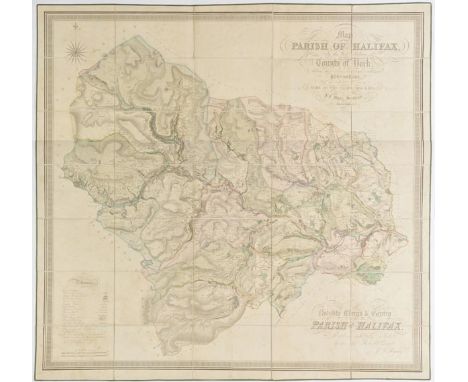
Los 217
Halifax. Bryars (J.F.), Map of the Parish of Halifax in the West Riding of the County of York, shewing the Township, Borough and Manorial Boundaries from an actual Survey made in the Years 1834 & 1835 by J.F.Myars, Surveyor, Halifax, circa 1835, large scale engraved map with contemporary hand colouring, sectionalised and laid on linen, calligraphic title and dedication, compass rose and a table of references, some spotting, 1110 x 1160 mm, contained in a contemporary blue calf book box with gilt decorated spine, a little worn and bumped at extremities (1)
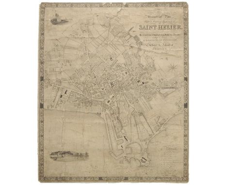
Los 221
Jersey. Cobley (C., engraver), This Geometrical Plan of the Town, Fort & Harbour of Saint Helier exhibiting at sight the proportional extent of every individual property within its limits, is dedicated by permission to the States of the Island of Jersey by Elias Le Gros, Civil Surveyor, 1834, uncoloured engraved town plan, vignette of a view of the Harbour and Fort Regent, compass rose and calligraphic title, laid on linen, heavily creased, some spotting, dust soiling and staining, some marginal fraying and closed tears, small areas of loss, 820 x 690 mm Although in poor condition this is a scarce plan of Saint Helier and is probably the first large-scale map of the town. Only two copies found on COPAC. (1)
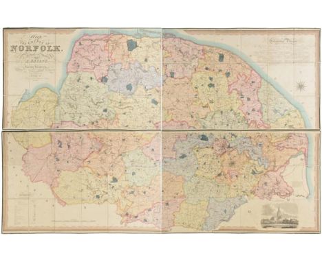
Los 241
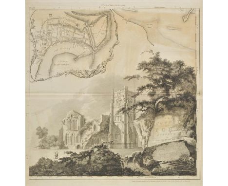
Norfolk. Bryant (Andrew), Map of the County of Norfolk from Actual Survey by A.Bryant in the Years 1824, 1825 and 1826, Respectfully dedicated to the Nobility, Clergy & Gentry of the County, published A.Bryant, Dec. 1st. 1826, large scale engraved folding map on two sheets, bright contemporary hand colouring, sectionalised and laid on linen, calligraphic cartouche, list of the ecclesiastical divisions, compass rose, table of explanation and uncoloured engraved vignette of Norwich Cathedral, bordered with green silk, each sheet approximately 740 x 2270 mm, contained in contemporary gilt calf solander box, rubbed, bumped and worn T.Chubb. A Descriptive List of the Printed Maps of Norfolk 1574 - 1916, page 106. (1)
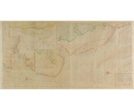
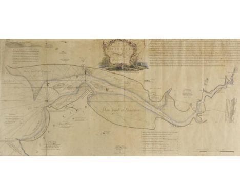
Los 253
*Sea chart. Mount (R. and Page T., publishers), Chart for the Newcastle Trade Describeing the Sea Coasts of England from the South Foreland to New-Castle with the Soundings, Sands, Shoals, Harbours, Buoys, Beacons and Seamarks upon ye said Coast, circa 1730, large hand coloured engraved chart orientated to the west on two conjoined sheets, inset maps of 'The River Tine and Coast from Sunderland to Blyth', 'Harwich and Hanford Water' and 'A Chart of Yarmouth Sands', compass rose and numerous rhumb lines, some creasing, toned overall, 505 x 1010 mm, framed and glazed (1)
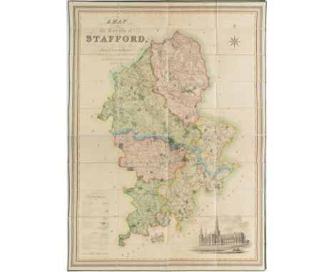
Los 258
Staffordshire. Phillips (J. & Hutchings W.F.), A Map of the County of Stafford, Divided into Hundreds & Parishes from an accurate Survey, made in the years 1831 and 1832, published Henry Teesdale, 1832, large scale engraved map with contemporary hand colouring, sectionalised and laid on linen, table of explanation, compass rose and an uncoloured vignette of Lichfield cathedral, slight offsetting and spotting, slight creasing to one section, 1320 x 975 mm, marbled endpapers, contained in a contemporary blind stamped mottled calf book box, a little worn at extremities (1)
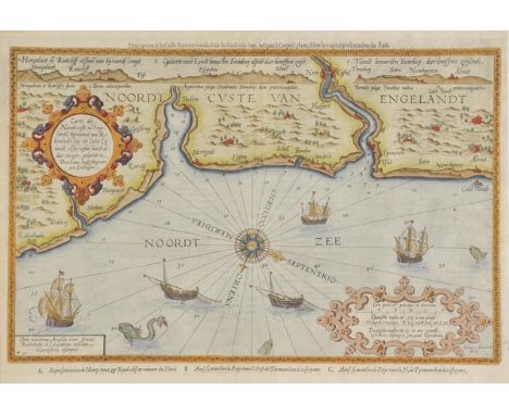
Los 262
Waghenaer (Lucas Janszoon). Carte der Noordt custe va Engelandt beginnende van Robibhodes bay tot Cocket Eijlandt alsoe Tzelve Landt aldaer in zyn gedaente is., circa 1596, hand coloured engraved sea chart of the north eastern coastline of England, engraved by Johannes von Deutecum, the map orientated to the West-south-west, decorated with a large compass rose, numerous rhumb lines, sailing ships and sea monsters, very slight creasing, slight text showthrough, 345 x 515 mm, French text on verso (1)
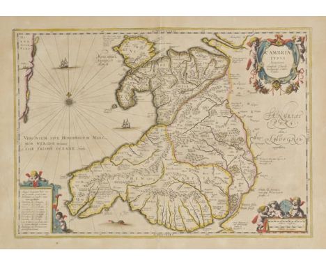
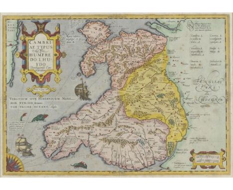
Los 266
Wales. Jansson (Jan & Mercator Gerard), Cambria Typus auctore, Humfredo Lhuydo Denbigiense Cambro Britanno, circa 1650, engraved map with contemporary outline colouring, decorative cartouche and mileage scale, compass rose and numerous rhumb lines, printers folds just affecting lower and upper left corners, slight overall toning, short split at base of central fold but not affecting image, 350 x 500 mm, Latin text on verso John Booth. Antique Map of Wales, no.5. (1)
Los 267
Wales. Jansson (Jan), Principatus Walliae pars Borealis vulgo North Wales, published Amsterdam, circa 1650, engraved map with contemporary hand colouring, decorative cartouche, and mileage scale, compass rose and numerous rhumb lines, some overall spotting, 410 x 520 mm, Latin text on verso, together with, Saxton (Christopher and Kip William), Penbrok comitatus olim pars Demetarum [and], Caermardi comitatus in quo Dimetae olim habitarunt, [1610], two hand coloured engraved maps, each approximately 275 x 325 mm, with Van den Keere (Pieter), Wales, circa 1637, hand coloured engraved map, 85 x 120 mm, English text on verso, plus Morden (Robert), A New and Correct Map of North-Wales, circa 1720, uncoloured engraved map, 360 x 425 mm, and Mallet (Alain Manesson), Principaut‚ de Galles, circa 1683, hand coloured engraved map, 155 x 100 mm, French text on verso, with eight other Welsh county maps by Hinton, Owen & Bowen, Morden, Kitchin and Archer and a hand coloured title page by Pieter Van den Keere, various sizes and condition (14)
Los 271
*Wales. Jones (William), A Plan or Directions for Ships to come in safe to Burry and to the several places of safety to lie within the same, 1757, engraved sea chart by Henry Gretton, sparse outline colouring, decorative cartouche, two inset tables of instructions and a table of reference, compass rose and numerous rhumb lines, old folds, some overall toning and slight spotting, some fraying with slight loss to upper margin just affecting image, 430 x 885 mm, mounted, framed and glazed Scarce. Only one copy recorded on Copac. (1)
Los 272
*Wales. Mercator (Gerard), Cambriae typus auctore Humfredo Lhuydo Denbigiense Cambobritanno, Petrus Kaerius caela, [1606 - 1633], hand coloured engraved map, elaborate strapwork cartouche and mileage scale, quarter compass rose and rhumb lines, slight spotting, 350 x 495 mm, mounted, framed and glazed (1)
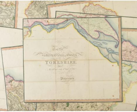
Los 289
Yorkshire. Greenwood (C.), Map of the County of York, made on the Basis of Triangles in the County, determined by Lieut. Col. Wm. Mudge, Royal Art. F.R.S. and Captn. Thos. Colby, Royal Eng. in the Trigonometrical Survey of England by order of the Honourable Board of Ordnance and Surveyed in the Years 1815, 1816 & 1817, published Robinson Son & Holdsworth, Leeds [and] John Hurst & C.Greenwood, Wakefield, June 4th 1817, large scale engraved map with bright contemporary hand colouring, sectionalised and laid on linen on nine sheets, calligraphic title and dedication, table of the altitudes of the principal mountains, compass rose and table of explanation, very slight dust soiling, each sheet approximately 615 x 720, all edged in green silk, contained in a modern calf book box with gilt decorated spine (1)
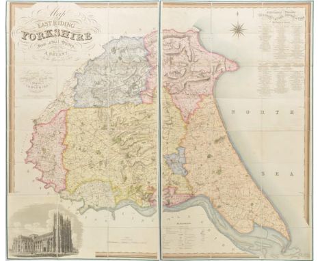
Los 291
Yorkshire. Bryant (A.), Map of the East Riding of Yorkshire from actual survey by A,Bryant in the Years 1827 & 1828, respectfully dedicated to the Nobility, Clergy & Gentry of Yorkshire, published A.Bryant, 1829, large engraved map sectionalised and laid on linen on two sheets, each sheet bordered in green silk, calligraphic title, compass rose, table of explanation and a table of the Ecclesiastical Divisions, uncoloured engraved vignette of Beverley Minster, slight offsetting, each sheet approximately 1350 x 760 mm, contained in a contemporary blind stamped calf book box with gilt decorated spine, some rubbing and wear (1)
Los 293
Yorkshire. Jefferys (Thomas), The County of York Survey'd in MDCCLXVII,VIII, IX and MDCCLXX, published Robert Sayer & John Bennett, 1775, large uncoloured engraved map on twenty sheets, decorative cartouche, large engraved vignette of Middleham Castle with dedication, table of references, compass rose and inset town plans of York, Scarborough, Leeds, Sheffield, Kingston-upon-Hull and Ripon, reduced index map of the County of York, slight dust soiling and offsetting, later endpapers, modern half calf with gilt decorated spine, contrasting red gilt morocco label to upper board, slim folio (1)
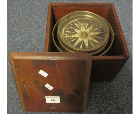
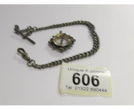
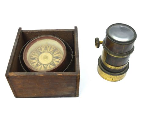
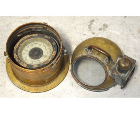
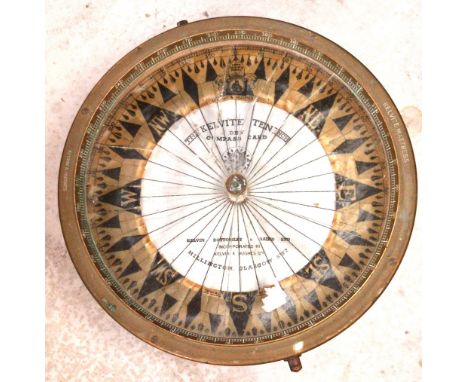
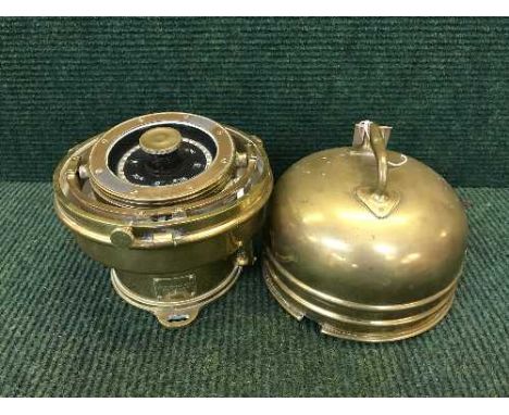
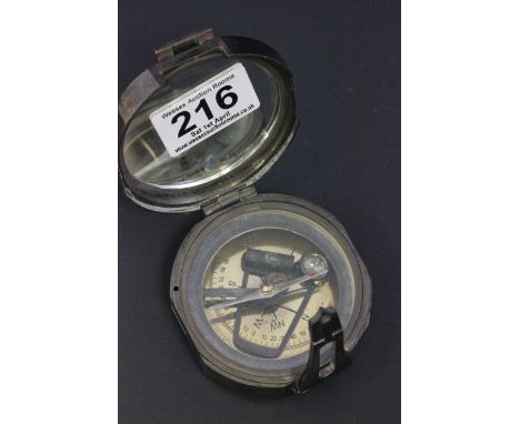
Los 56
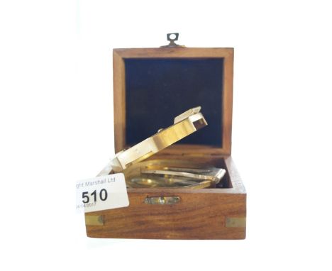
Brass gimballed card compass in original fitted wooden box with sliding cover.(B.P. 24% incl. VAT) CONDITION REPORT: Compass card very dirty/stained and also loose. Surface wear/scratches to brass, glass and box.Outside dimensions: 20.5cm x 20.5cm incl. boxName in middle - WHYTE & COMPANY GLASGOW
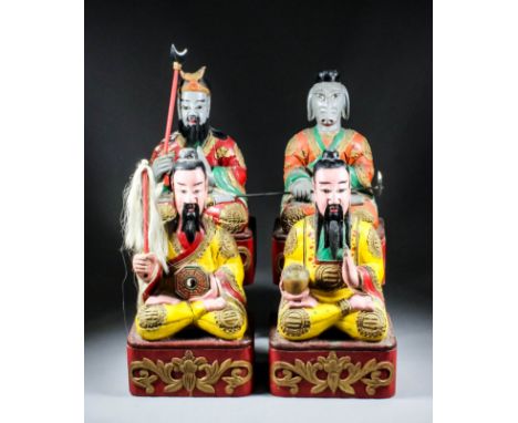
Los 884
A pair of Chinese carved polychrome seated figures of bearded Daoist gods, their yellow robes decorated with tri-grams, one holding a bowl and the other a fly whisk and compass, on red painted and stylised lotus bases, each 17ins (43cm) high, and a pair of figures of a seated Zhu Bajue, "Pigsy", the Chinese Spirit of Greed, and a deity, each with grey features, on similar red painted and stylised lotus bases, each 16.5ins (42cm) high Note : Zhu Bajue - Purchased in Hong Kong in 1976.
Los 962
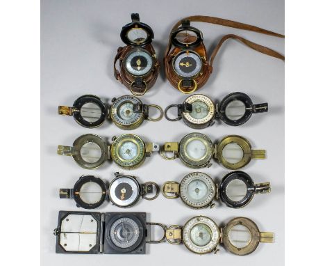
A George V World War I Verner's pattern brass cased prismatic compass by T.Cook & Sons Ltd", No.42195, dated 1916 and with broad arrow, contained in original leather case, stamped "Pulley & Powell 1916", another stamped with broad arrow and "F-L", No.79988, dated 1917, contained in original leather case stamped "T.French & Son, London 1917", and with broad arrow, together with a small collection of compasses of military and civilian interest, various (27)
Los 277
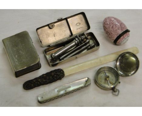
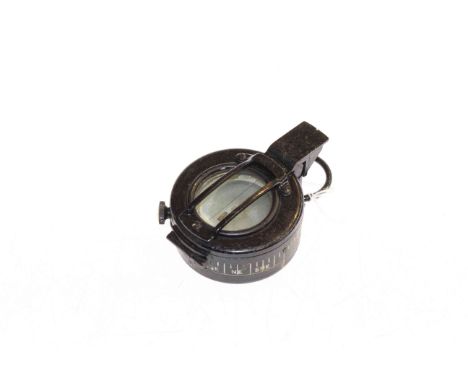
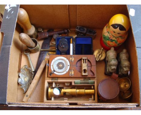
A mixed lot to include a cased WWI compass by F.Barker and sons, an Evercut Swiss cigar cutter, a cased brass students microscope, a six inch brass bound rule and level, a rosewood and brass wafer stamp along with various other objects including a made in the U.S.S.R labeled Matryoshka doll.
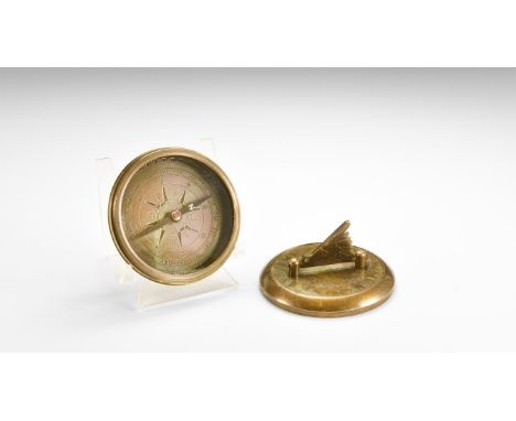
Los 180
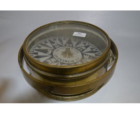
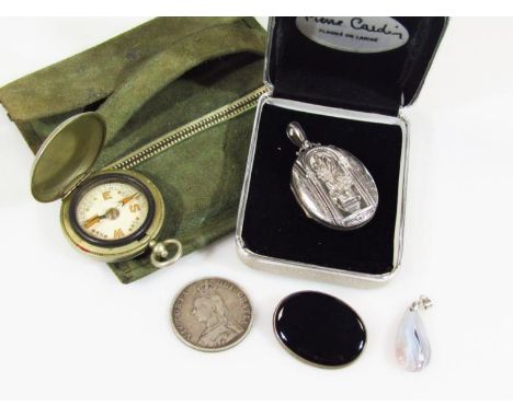
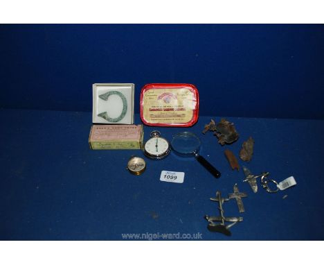
20th century AD. A discoid brass case with folding gnomon to the upper face, incised Roman numerals and 'Gilbert Sundial' legend; screw lid opening to reveal glass screen and compass; garbled instructions to the underside of the lid On a sunny day raise the vene, hold of lay your compass level with north end of pointer which marked lined up 12 o'clock (Roman Numeral XII) this also north. The shadow cost across the dial will give you the approximate time.; rising sun symbol and 'Gilbert Sundial' to the underside. 214 grams, 76mm (3"). From an old North Country collection; formed between 1970-2000. . Very fine condition.
-
36562 Los(e)/Seite