36562 Preisdatenbank Los(e) gefunden, die Ihrer Suche entsprechen
36562 Lose gefunden, die zu Ihrer Suche passen. Abonnieren Sie die Preisdatenbank, um sofortigen Zugriff auf alle Dienstleistungen der Preisdatenbank zu haben.
Preisdatenbank abonnieren- Liste
- Galerie
-
36562 Los(e)/Seite

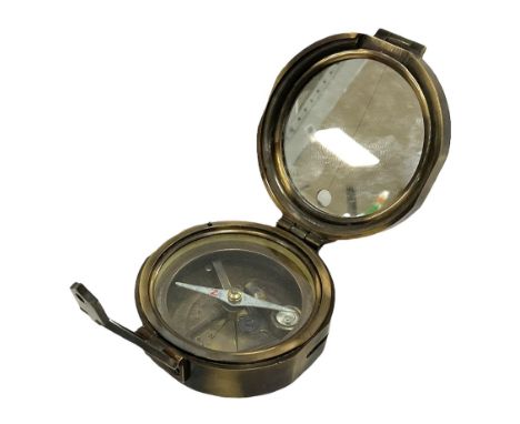
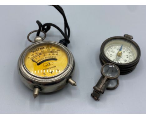
Los 267
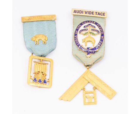
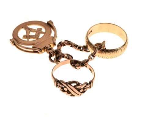
Two 9ct gold masonic medallions, to include on with enamelled central badge Lodge of the Golden Fleece, overlaid to ribbon with 9ct gold fitting, suspending a 9ct gold compass and square, along with another 9ct gold 'Founder' medallion ribbon suspending ship motif inset with blue enamel, 9ct gold fittings, combined total gross weight approx 45gms one casedFurther details: Good enamel intact, wear and tear commensurate with age
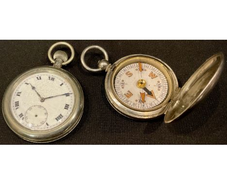
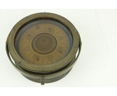
Los 189
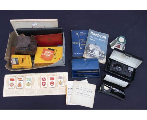
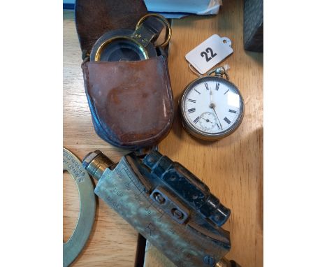
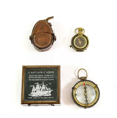
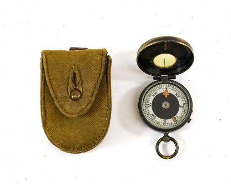
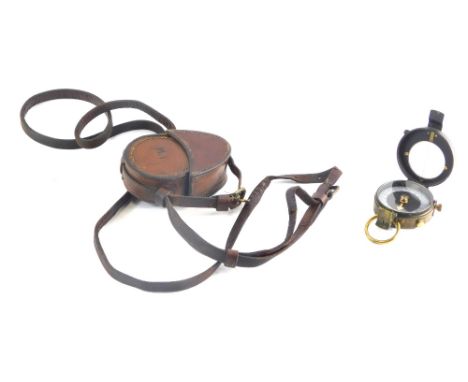
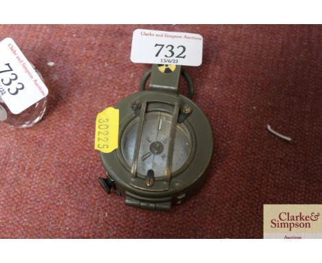
A First World War Non-Prismatic Marching Pocket Compass, the brass case with traces of the original black finish, the free spinning card compass dial with silvered bearing ring, the notched rotating top ring with black bearing line, the case with lenticular window, manual stop lever and finger brake, in a canvas case with leather belt loop, formerly the property of Major J.H.Smeddle, 8th Bn. Durham Light Infantry.
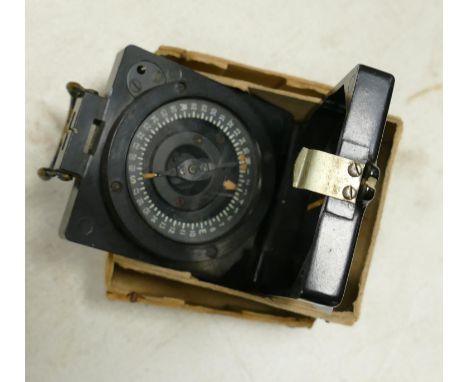
Los 224
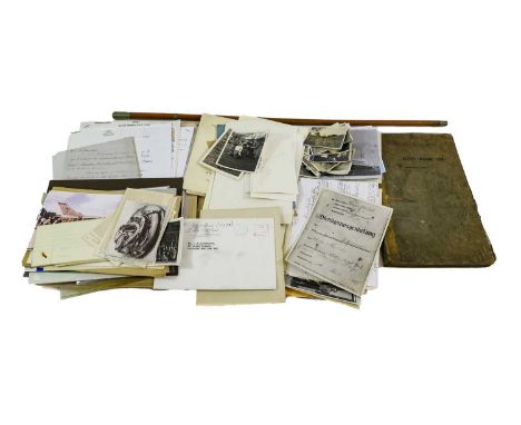
A Quantity of Militaria, including a King's Own swagger stick, a blackened brass compass with green card dial, mixed ephemera including two Regular Army Certificates of Service, a Royal Navy Certificate of Service, Soldier's Service and Paybook, Army Book 129, a booklet - The German Raid on Scarborough December 16th 1914, numerous photographs etc.
Los 383
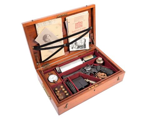
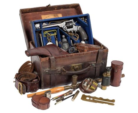
A Second World War Army Officer's Mahogany Cased Compendium, the interior fitted with a deactivated Webley Mark IV Service Revolver with War Finish, numbered 144259, with a deactivation certificate dated 18/04/2019 and a lanyard, eight .38 inert bullets, a CYMA top wind pocket watch in a chromium plated case stamped with broad arrow G.S.T.P. T 24208, with fob chain, an Adie Bros whistle marked WD 1940, an Army issue black gripped Jack knife WD marked and dated 1944, a Mark 1 magnetic marching compass, an oil bottle, hip flask, two cigarette lighters, a Gillette shaving set in tin, ephemera including War Office booklets - Hints on Map Reading, Small Arms Training, The Soldier's Welfare, maps etc.The revolver has been deactivated and has a current EU deactivation certificate. The barrel has been cut to the underside, it still breaks at the cylinder (which has been filled), for loading and the trigger operates the cylinder. There are some areas of pitting to the left side of the frame.The Cyma pocket watch has small dents to the back of the case. The movement will not wind, although the hands can be moved and the subsidiary seconds hand works for a while after the watch has been moved. There is a fine crack to the dial. The compass is in good working order. The clasp knife has some rust pitting to the metalwork, but no damage. The whistle is working. There is some dog earring to the paperwork, but nothing serious. The case has minor bruising but is generally in good condition. The set is nicely presented.
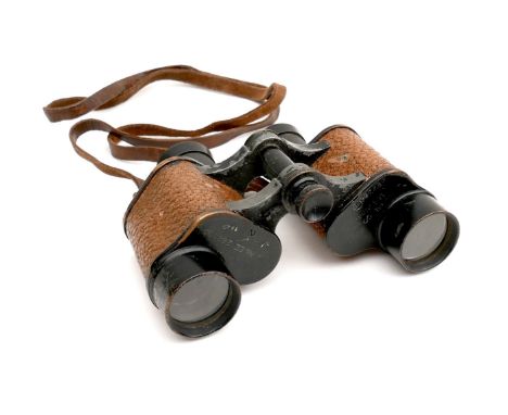
Los 385
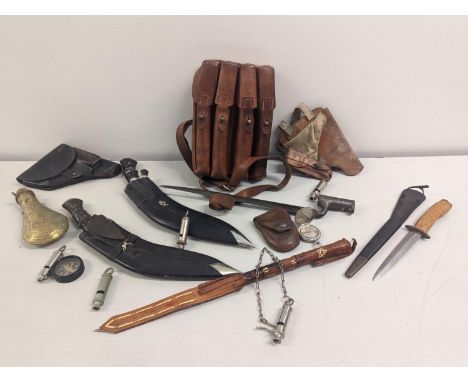
A First World War Army Officer's Leather Cased Compendium, with a fitted lift-out tray containing a deactivated Webley Mark VI Service Revolver, dated 1916 and with War Department markings, together with a deactivation certificate dated 18/04/2019, six inert .455 bullets and a lanyard, a white metal grease pot, a brass folding 'sit on map' magnifying glass, a steel cigarette lighter, a vesta case, a hip flask, a J Hudson & Co. whistle with WD arrow and lanyard, an army issue Encore folding knife with Marlin spike by T Turner & Co., an open faced pocket watch by E Elilaida, London, the plated case with WD arrow and numbered D69012 with chain link fob, a glass bottle and cover and a pair of spectacles, with a War Office Map of North West Europe sheet 4 1914, War Office Map of Abbeville, France, Nov.1915, an English/Flemish Phrase Book, an Active Service Testament 1917 and six postcards; the base of the case containing a leather Webley Mark VI pistol holster dated 1916, a leather Sam Browne with shoulder strap, a field spotting monocular in a leather case dated 1914, a pair of Brooks binoculars in leather case dated 1916, an R & J Becks Mk2 trench periscope with detachable wood handle dated 1918, a Verner's pattern prismatic marching compass in leather case dated 1915, a leather cased shaving set and other accessories, the inner cover of the case with paper label for Army & Navy Co-Operative Society Gun Department.

Los 22
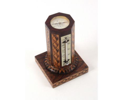
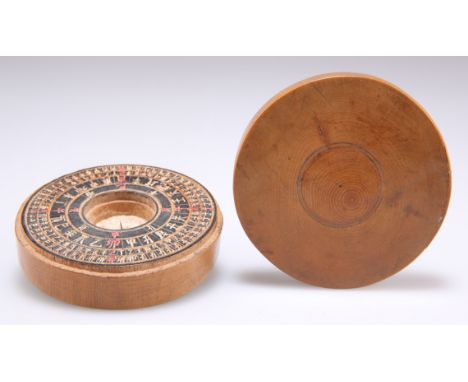
A Tunbridge ware combination desk thermometer/compass by Edmund Nye, the square rosewood base bordered by chain form mosaic and supporting a stick ware collar to an octagonal body mounted with a mercury thermometer the scale engraved 'E. Nye - Tunbridge Wells' within seven panels of floral mosaic, the top inset with a circular compass and lacking the original stick ware surround now veneered in rosewood. The base with printed label 'Edmund Nye, Manufacturer Mount Ephraim and Parade, Tunbridge Wells', 8.4cms sq. at base, 13cms high. From the collection of Enid Riley Part 3
Los 98
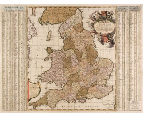
England & Wales. Visscher (Nicolas), A New Mapp of the Kingdome of England, Representing the Princedome of Wales and other Provinces, Cities, Market Towns, with the Roads from Town to Town and the Number of Reputed Miles between them, are given by Inspection without Scale or Compass. Printed and given out at Amsterdam by Nicolas Visscher upon the Dam at the signe of the Fisher, with priviledge of ye states generalls and are to be sould at London by John Overton at the White Horse without Newgate, circa 1694, large separately published engraved map with contemporary hand colouring, ornate cartouche and alphabetical tables of cities and towns to the vertical margins, the tables printed on separate sheets and conjoined to the map, old folds, slight creasing, some oxidization to old watercolour, the map (but not the tables) backed with archival tissue, 580 x 770 mm, together with Moll (Herman). The South Part of Great Britain called England and Wales..., J. & T. Bowles, Philip Overton and John King, 1710, [but circa 1732], engraved map on two conjoined sheets, contemporary outline colouring and some later enhancement, tables of towns to both vertical margins, slight staining, old folds split with very slight loss, strengthened and repaired on verso, some marginal closed tears, slight toning and staining to old folds, 610 x 970 mm, QTY: (2)NOTE:R. W. Shirley. Printed Maps of the British Isles, 1650 - 1750. The first described map. Visscher 2. state. 4. The second map. Moll 7. state 3.
Los 107
Herefordshire. Taylor (Isaac), To my Worthy Subscribers in general but more particularly to those Noblemen, Gentlemen etc; who honoured me with their Assistance, This New Map of the County of Hereford engraved from the Original Drawing made from an Accurate Survey proved by Trigonometry is most Humbly dedicated by their Obedient Humble Servt....., Ross-on-Wye, Jany. 1st. 1754, uncoloured large scale map, engraved by Thomas Kitchin, on four sheets, two conjoined, the margins decorated with 288 shields, but with only 77 allotted (indicating Taylor's struggle to attract subscribers), compass rose, mileage scale and decorative allegorical cartouche, an inset town plan of Hereford, occasional marginal repaired closed tears, each sheet approximately 610 x 560 mm, two conjoined and framed and glazed in 3 uniform framesQTY: (3)NOTE:The first and one of the rarest of Isaac Taylor's large-scale surveys probably failed on a purely financial basis because the lack of wealth and the sparse population of a largely rural county made it very difficult to raise sufficient support and sponsorship. With only 77 subscribers it is believed that probably less than 100 maps were eventually printed, with only a few surviving to the present day. Taylor's subsequent maps do not feature sponsor's coats of arms, probably indicating that he was disappointed with the funds which were raised.
Los 125
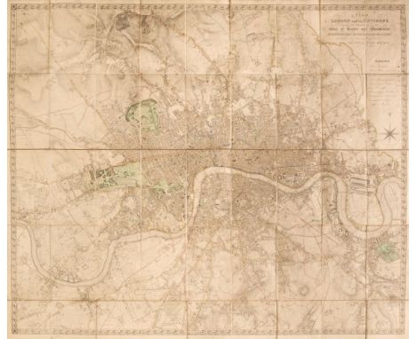
London. Lewis (Samuel). A Plan of London and its Environs Shewing the Boundaries of the Cities of London and Westminster, Metropolitan Boroughs and Parishes and Distances in Miles & Quarters of the Principal Roads from the General Post Office, circa 1850, engraved map by J.Dower, original outline colouring, sectionalised and laid on linen, calligraphic title, table of explanation and compass rose, a little dust-soiled, 940 x 1110 mm, contemporary morocco gilt board (lacking the upper board), frayed and worn QTY: (1)NOTE:James Howgego. Printed Maps of London 1553 - 1850, 373a, state 2.
Los 148
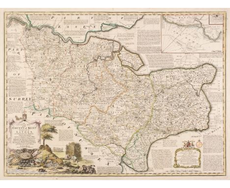
South-East England. A collection of 10 maps, 17th - 19th century, engraved maps of Kent, Essex, Buckinghamshire, Sussex and Suffolk, including Bowen (Emanuel). An Accurate Map of the County of Kent Divided into its Lathes, and Subdivided into Hundreds..., J. Tinney, 1753, engraved map with contemporary outline colouring and some later enhancement, originally published in 'The Large English Atlas', inset map of the Downs, old folds, one repaired closed tear affecting the printed image, 530 x 710 mm, together with An Accurate Map of the County of Essex, Divided into Hundreds; Drawn from Surveys..., Robert Wilkinson, Bowles & Carver and Laurie & Whittle, circa 1762, engraved map with contemporary outline colouring and some later enhancement, originally published in 'The Royal English Atlas', slight staining to the central fold, 410 x 495 mm, with Saxton (Christopher & Kip William). Sussexia sive Southsex olim pars Regnorum, circa 1637, hand-coloured engraved map, large strapwork cartouche, mileage scale and compass rose, 225 x 390 mm, plus Blome (Richard). A Mapp of Buckinghamshire with its Hundreds, circa 1673, hand-coloured engraved map, 320 x 260 mm, and Blaeu (Johannes). Regiones Inundatae in sinibus Comitatus Norfolciae, Suffolciae, Cantabrigiae, Huntingtoniae, Northamptoniae et Lincolniae, Amsterdam, circa 1648, engraved map with contemporary outline colouring, slight creasing, 440 x 540 mm, Latin text on verso, with Bowen (Thomas). Suffolk Divided into Hundreds, Exhibiting the County, Borough and Market Towns..., T. Kitchin [1765 - 77], engraved map with contemporary outline colouring, originally published in 'The Atlas Anglicanus', 225 x 330 mm, with another four maps similar, including examples by Greenwood, Kirby and Butters, various sizes and conditionQTY: (10)
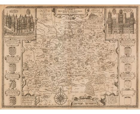
Los 150
Surrey. Speed (John), Surrey Described and Divided into Hundreds, John Sudbury & George Humble, circa 1627, uncoloured engraved map, inset views of Richmond and Nonsuch palaces, very slight spotting, light overall toning, upper right corner with repaired closed tear, central fold strengthened on verso, 385 x 515 mm, English text on verso, together with Morden (Robert). Surrey [1695 or later], hand-coloured engraved map, slight mount staining, one short repaired closed marginal tear, 355 x 420 mm. with Greenwood C. & J.). Map of the County of Surrey from an Actual Survey made in the years 1822 & 1823, Greenwood & Co. July 4th 1829, engraved map with contemporary hand-colouring, calligraphic cartouche, compass rose, tables of reference and explanation, uncoloured oval vignette of Lambeth Palace & Church, slight offsetting, 570 x 680 mmQTY: (3)
![Wales. Speed (John), Montgomery Shire, Thomas Bassett & Richard Chiswell [1676], hand-coloured engraved map, inset plan o](https://cdn.globalauctionplatform.com/21b22f34-a274-4e72-bd63-aea600d93d9e/db33dc23-ddf1-4678-a800-aea60102b2e6/468x382.jpg)
Los 154
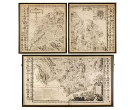
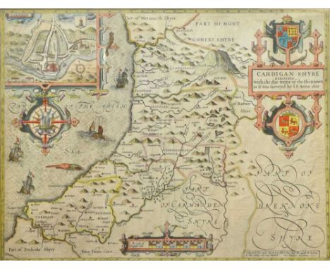
Wales. Speed (John), Montgomery Shire, Thomas Bassett & Richard Chiswell [1676], hand-coloured engraved map, inset plan of Montgomery, large strapwork cartouche and compass rose, slight overall toning, occasional marginal closed tears, 385 x 515 mm, English text on verso, together with Blaeu (Johannes). Glamorganensis Comitatus vulgo Glamorgan Shire, Amsterdam, circa 1658, engraved map with contemporary hand-colouring, toned overall, slight dust soiling, 385 x 510 mm, Latin text on verso, with Kitchin (Thomas). An Accurate Map of Cardigan Shire drawn from an Actual Survey..., An Accurate Map of Brecknockshire Drawn from an Actual Survey..., [and] An Accurate Map of Carmarthenshire Drawn from an Actual Survey..., circa 1765, together three engraved maps with contemporary outline colouring and some later enhancement to the cartouches, originally published in 'The Large English Atlas', one horizontal margin extended on each map (where separated), each approximately 355 x 530 mmQTY: (5)
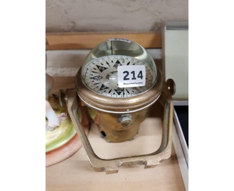
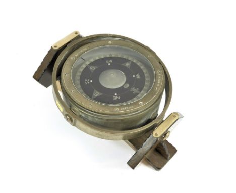
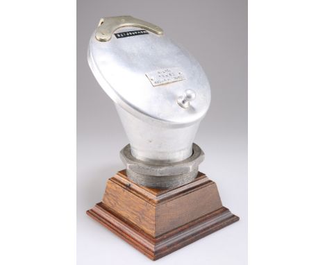
Los 70
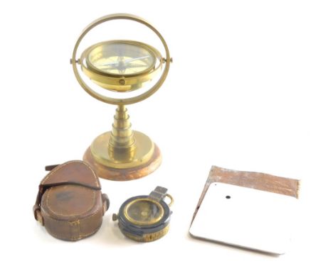
GIMBAL COMPASS. A naval brass gimbal compass with crows foot arrow & No. 3153.H.S. Now mounted on a wooden stand decorated with two naval uniform buttons. Diameter 21cm. Please note that all items in this auction are previously owned & are offered on behalf of a private vendor. If detail on condition is required on any lot(s) PLEASE ASK FOR A CONDITION REPORT BEFORE BIDDING. The absence of a condition report does not imply the lot is perfect.WE CANNOT SHIP THIS LOT due to fragility, size or weight. Our recommended carrier is MBE Plymouth on +44 (0) 1752 257224 or info@mbeplymouth.co.uk
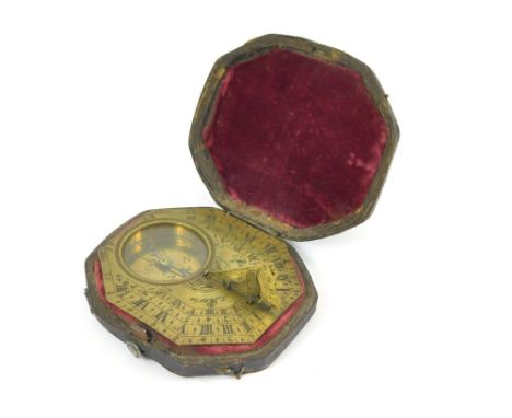
Los 71
PORTABLE SUNDIAL/COMPASS. An 18th century horizontal, portable sundial compass, the octagonal base plate signed Menant, Paris. The Butterfield-type instrument with hinged gnomon, featuring a bird. The reverse engraved with various cities & their latitudes. Original leather, velvet lined octagonal case with button & hooks. 7.3 x 6.5cm. Please note that all items in this auction are previously owned & are offered on behalf of a private vendor. If detail on condition is required on any lot(s) PLEASE ASK FOR A CONDITION REPORT BEFORE BIDDING. The absence of a condition report does not imply the lot is perfect.WE CAN SHIP THIS LOT, but NOT if part of a large, multiple lots purchase.
Los 516
TWO BOXES OF METALWARES, MILITARY BOX, BINOCULARS, ROTARY TELEPHONE AND SUNDRY ITEMS, to include a wooden military box for a compass or similar equipment, marked with the broad arrow and T-378, approximate measurements width 26cm x height 16cm x depth 21cm, Nikko Stirling 7 x 50 and Prinzlux 12 x 50 cased binoculars, a black rotary telephone, a modern brass candle lantern, a Fortnum and Mason wooden box with four inner compartments (possibly for tea bags), various candelabra and other candleholders, etc (sd) (2 BOXES)
Los 191
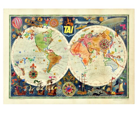
Original vintage travel advertising poster for TAI Transports Aeriens Intercontinentaux Map of the World by Luc-Marie Bayle (1914-2000) featuring a colourful planisphere map showing the airline's routes around the globe surrounded by fun images of explorers in different modes of transport from hot air balloons and an early Wright flyer to a modern TAI plane and rowing boats to a paddle steamer and sailing ships with fish and birds on both sides of a decorative compass point below, the bold yellow TAI coat of arms title text between the stars in the night sky above. In 1963, TAI merged with Union Aeromaritime de Transport to form UTA French Airlines (merged into Air France in 1992). Horizontal. Good condition, creasing, tears, staining. Country of issue: France, designer: Luc Marie Bayle, size (cm): 58x80, year of printing: 1950s.
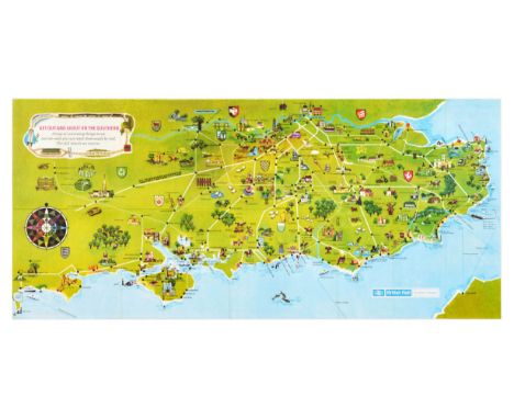
Los 216
Original vintage travel poster - A Pictorial Map of Southern England including over 200 places of interest to visit by rail with details of Southern Region facilities - by British Rail Southern Region - Get out and about on the Southern A map of interesting things to see and do-and you can reach them easily by rail. - featuring colourful illustration with a compass, marking places of interest and coats of arms. Horizontal. The Southern Region was a region of British Railways from 1948 until 1992 when railways were re-privatised. The Southern Region also inherited some independent light railways, namely the East Kent Light Railway, the Kent and East Sussex Railway and the North Devon and Cornwall Junction Light Railway. Richmond Railway Bridge spanning the Thames in Richmond upon Thames. The Southern Region served southern London, Brighton, Kent, Surrey, Sussex, Hampshire, the Isle of Wight, and some areas of Dorset, Wiltshire and Berkshire. Good condition, folds as issued, small tears, small paper loss on edge, minor staining, double sided. Country of issue: UK, designer: Unknown, size (cm): 39x86, year of printing: 1970s.

Los 57
Original vintage advertising poster by Air France for Postal Air Network featuring a map of the world marking connecting foreign lines, with a compass, an inset of Europe, seahorse (pegasus / hippocampe aile) logo, and title on a white ribbon, held together by a red frame. Printed by Perceval, Paris. Horizontal. Good condition, creasing, staining, tears on edges Country of issue: France, designer: Unknown, size (cm): 65x100, year of printing: 1940s.
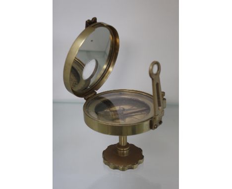

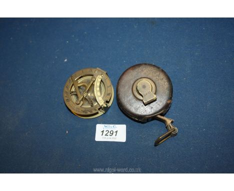
Los 1291
An unusual Brass Compass and Sundial combined with fold-down parts including an inclination scale and engraved ''F.L. West, 31 Lock Spur F.L., London'', 2 1/2'' diameter x 2 1/8'' high (glass to compass cracked), sold together with a leather cased 12 ft. Tape Measure by John Rabone, apparently marked in hands and fractions thereof (some wear and end tape repaired).
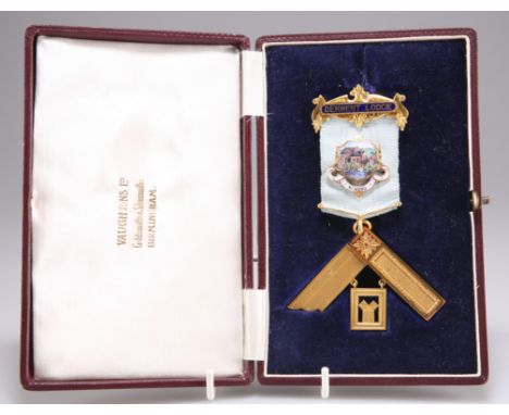
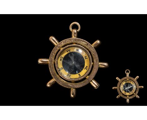
Los 384
A 9 CARAT GOLD MASONIC PAST MASTERS JEWEL, presented to W. Bro. John Cheeseman of Derwent Lodge, engraved presentation inscription verso, hallmarked Vaughton & Sons, Birmingham 1931, 35.1 grams gross, in a fitted presentation caseCONDITION REPORTGood overall condition. The compass is hallmarked and weighs 19.2 grams, the other elements believed to be gilt metal.
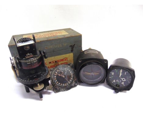
Los 652
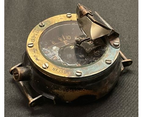
THREE BRITISH MILITARY AIRCRAFT INSTRUMENTS comprising an S. Smith & Sons, London clock, Mk IIIB, No.830/39, Ref. No.6A/839, the part luminous Arabic numeral 24-hour circular dial with subsidiary Time of Trip dial, the case impressed to the reverse '[crown] A.M.', and '830'; a Kelvin & Hughes Altimeter Mk 14A, Ref. 6A/3380, serial no.3769/59, the case marked to the reverse with an ordnance arrowhead; and an Artificial Horizon Mk II, Ref. No. 6A/711, serial no.5289/36, the case with 'AM' mark; together with an Astro Compass Mk II, Ref. 6A/11740, in original grey-painted fitted case, (4).
Los 144
John Speed, 17th Century hand-coloured engraved map of Cardiganshire: Cardigan Shyre Described with the due forme of the Shire Towne as it was surveyed by J. S. in 1610, John Sudbury & George Humble, (1611 - 27), , large strapwork cartouche and compass rose, an inset town plan of Cardigan, 38.5cm x 51cm, text verso, framed and glazed to both sides


-
36562 Los(e)/Seite