36562 Preisdatenbank Los(e) gefunden, die Ihrer Suche entsprechen
36562 Lose gefunden, die zu Ihrer Suche passen. Abonnieren Sie die Preisdatenbank, um sofortigen Zugriff auf alle Dienstleistungen der Preisdatenbank zu haben.
Preisdatenbank abonnieren- Liste
- Galerie
-
36562 Los(e)/Seite

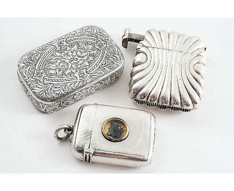
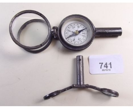
Los 628
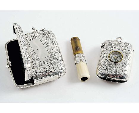
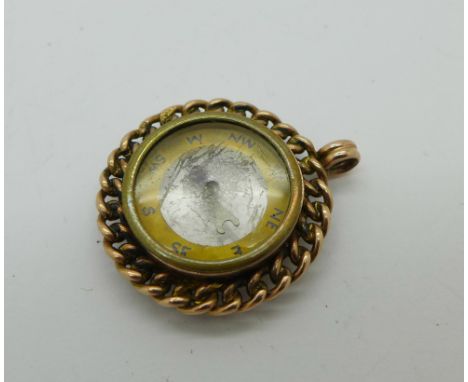
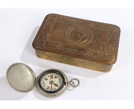
A LATE VICTORIAN SILVER PUZZLE-OPENING VESTA CASE with engraving, by Alfred Taylor, Birmingham 1870, silver "Unity Patent" vesta case and cigar cutter combined, by Horton & Allday, Birmingham 1890, and a silver vesta case with later-added compass, hallmarked Birmingham 1901; the "puzzle" vesta 2.45" (6.2 cms) long; 3.9 oz (3)
Los 529
A late 19th or early 20th century Dresden style coffee set, comprising five cups, five saucers, teapot and sucrier, the cups raised on three paw feet and each painted with figures and putti, pale pink and blue bodies, gilt detailing and gilt compass stars to saucers, apparently unmarked, 11cm and smaller. (12)

Los 42
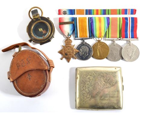
A First / Second World War Medal Group, to 69565 GNR. (later SJT.) A.J.POOK.R.A., comprising 1914 Star with Mons clasp, British War Medal, Victory Medal, Defence Medal and War Medal 1939-45, together with a ribbon bar with rosette, military issue marching compass by Mordan & Co., numbered 65736 and dated 1917, in pigskin case, and a plated presentation cigarette case First World War medals all with small dings, scratches and some wear. Compass with loose composition ring on back. General signs of wear commensurate with age and use. Cigarette case with dents and general wear to plating.

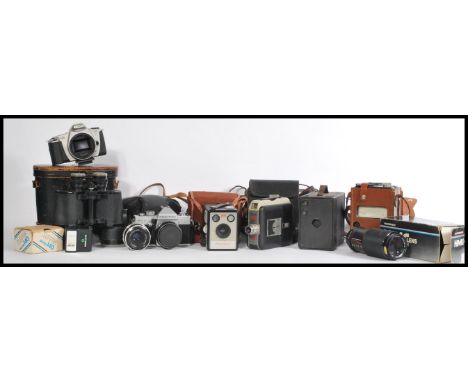
Los 367
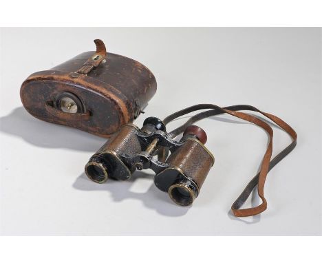
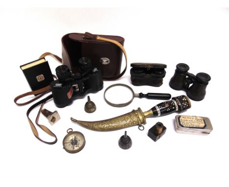
A collection of vintage cameras to include a Kodak Brownie Flash III, Praktica MTL3, a cine Kodak eight 55 film camera, a Canon EOS 300, a HMC hanimex objectif lens 80-200mm, a Carl Zeiss Jena Tessar 2.8/50 along with a leather cased pair on binoculars with a compass to the lid. Binoculars measure 19 cm high and 321 cm wide.
Los 322
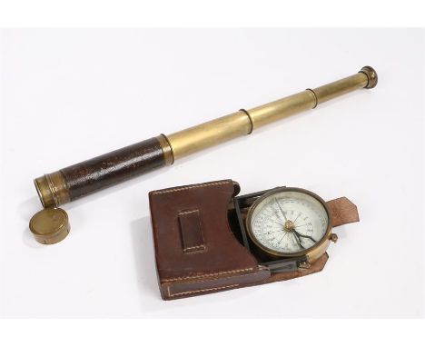
A quantity of metalware to include 'Retour de Chasse' after A Moreau, a patinated brass figure of blindfolded girl, table centrepiece with red glass bowl and four trumpets, three miniature miners' lamps, Stanley of London brass-cased compass, small chamber stick, two-division wine cooler, silver-plated bottle coaster etc.
![*Berkshire. Speed (John), Barkshire described, 1st edition, published John Sudbury & George Humble, [1611], hand coloured eng](https://cdn.globalauctionplatform.com/3690c511-8e71-437a-8bbb-a96100bdb491/b0ec8eff-ea3f-4804-b96d-2b1ac81fd29e/468x382.jpg)
Los 156
England & Wales. Mogg (Edward), Mogg's map of steam Navigation/Map of the United Kingdom of Great Britain & Ireland..., 1834, engraved map with contemporary hand colouring, sectionalised and laid on linen, first title printed above map, second title on map surface, inset map of the Shetland and Orkney islands, table of references, compass rose, slight spotting and staining, 760 x 595 mm, contained in a contemporary marbled card slipcase with printed label, heavily worn and frayed, together with Cary (John), Cary's reduction of his larger map of England and Wales and part of Scotland..., 1805, engraved map with contemporary outline colouring, sectionalised and laid on linen, slight spotting and staining, 760 x 615 mm, contained in a contemporary marbled card slipcase, frayed at extremities, with Cruchley G. F.), A Geographical companion through England & Wales including part of Scotland, 1822, engraved map with contemporary outline colouring sectionalised and laid on linen, slight spotting, 950 x 650 mm, contained in a contemporary card slipcase with printed label to upper board, stained and with slight wear, plus Bowles (Carington, publisher), Bowles's new travelling map of England and Wales exhibiting all the direct and principal cross roads with the distances in measured miles, 1789, engraved map with contemporary outline colouring, sectionalised and laid on linen, several splits along old linen folds,slight staining, 605 x 525 mm, contained in a near contemporary sheep wallet with printed label to upper cover, worn (4)
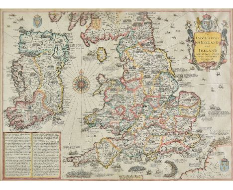
Los 159
*England, Wales & Ireland. Speed (John), The Invasions of England and Ireland with al their civill wars since the conquest, Thomas Bassett & Richard Chiswell, [1676], hand coloured engraved map by Cornelius Danckerts, decorative cartouche, compass rose and numerous rhumb lines, 385 x 520 mm, mounted, framed and double glazed, English text on verso R. W.Shirley. Early Printed Maps of the British Isles, 1477 - 1650, no.397. (1)
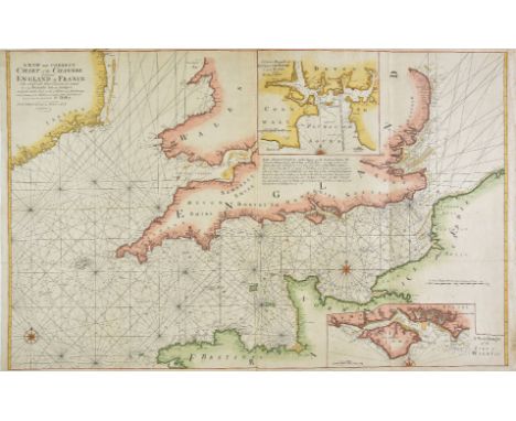
Los 160
English Channel. Mount (Richard & Page Thomas), A new and correct chart of the Channel between England & France with considerable improvements..., [1730 or later], large hand coloured engraved sea chart, inset maps of Plymouth Sound and The Isle of Wight, compass rose and numerous rhumb lines, old folds, one short split along old fold, 640 x 1015 mm (1)
Los 162
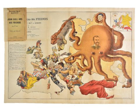
Europe. Rose (Fred W.), John Bull and his friends. A serio-comic map of Europe by Fred W. Rose. Author of "Angling in Troubled waters" &c. &c., G. W. Bacon & Co. Ltd., 1900, colour lithographic map, inset map of Europe, table of reference describing the state of each nation, old folds strengthened on verso, very slight browning to some folds, retaining original cardboard wrappers, 495 x 695 mm A highly pictorial political caricature map of the countries of Europe, dominated by the enormous octopus which is Russia; whose tentacles stretch out to all points of the compass and grasp hold of Persia, China, Poland, Scandanavia and the Balkans. France and Spain are are depicted as attractive women, while Germany, Italy and England are military commanders. 'Octopus maps' are a well used cartographic conceit but this is one of the boldest and most graphic of all of the allegorical maps showing Britain and her allies' determination to resist what were held to be Russia's overweening territorial ambitions. The map has an unnerving and striking prescience with the current unpredictability and reckless behaviour of the current embodiment of the Russian state. (1)
Los 177
*London. Cruchley (G. F.), Cruchley's new plan of London improved, circa 1850, engraved map with contemporary outline colouring, sectionalised and laid on linen, some worming affecting image, slight smudging to watercolour, 525 x 1395 mm, patterned endpapers, together with Greenwood (C. & J.), Map of the county of Somerset from an actual survey..., 1829, engraved map with contemporary outline colouring, calligraphic title, compass rose and engraved vignette of Wells cathedral, some overall toning, laid on card, slight spotting and dust soiling, 580 x 705 mm, framed and glazed, with Letts, Son & Co. (publishers), Untitled Ordnance Survey map of north east Kent, circa 1860, engraved map with contemporary outline colouring, sectionalised and laid on linen, some spotting, 635 x 940 mm, framed and glazed (3)
Los 184
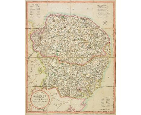
Norfolk and Suffolk. Ebden (William), Laurie & Whittle's new map of Norfolk and Suffolk divided into hundreds; exhibiting the whole of the mail, direct & principal cross roads, gentlemen's seats, rivers &c. &c. Robt. Laurie & Jas. Whittle, 5th November, 1811, engraved map with contemporary outline colouring, sectionalised and laid on linen, circular cartouche, table of explanation, two tables of reference to the hundreds and compass rose, 715 x 570 mm, contained in a contemporary marbled card slipcase, split and worn An uncommon map. (1)
Los 200
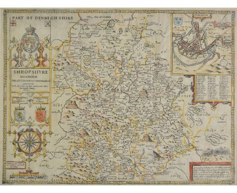
*Shropshire. Speed (John), Shropshyre described. The sittuation of Shrowesbury shewed with the armes of thos earles and other memorable things observed, George Humble, [1627], hand coloured engraved map, inset town plan of Shrewsbury, large strapwork cartouche and compass rose, 385 x 505 mm, English text on verso, mounted, framed and double glazed (1)
-
36562 Los(e)/Seite