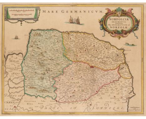

Norfolk & Suffolk. Jansson (Jan), Norfolciae Descriptio. The Description of Norfolk, published Amsterdam, circa 1638, engraved map with contemporary outline colouring, slight overall toning, printer's folds, 385 x 495 mm, no text on verso, together with Jansson (Jan). Nortfolcia vernacule Norfolke, published Amsterdam, circa 1648, engraved map with contemporary outline colouring, slight staining, 385 x 485 mm, French text on verso, with Greenwood (C & J). Map of the County of Norfolk from an Actual Survey made in the years 1832 and 1832..., published 1st April 1834, engraved map with contemporary wash colouring, calligraphic cartouche, compass rose, table of reference and an uncoloured vignette of Norwich cathedral, some spotting but largely confined to the margins, closed tears affecting the printed image, 580 x 705 mm, plus Walker (J & C). Norfolk, circa 1880, engraved map with contemporary outline colouring, originally published in 'Walker's Fox-Hunting Atlas', very slight spotting, 325 x 395 mm, and Morden (Robert). Suffolk [1695 or later], uncoloured engraved map, printer's folds, 355 x 420 mm, with an uncoloured example of Thomas Moule's map of Cambridgeshire QTY: (6)NOTE:The first described item is in the scarce 'pre-atlas' state printed before the addition of the seven coats of arms and a re-working of the title cartouche.
36562 Preisdatenbank Los(e) gefunden, die Ihrer Suche entsprechen
36562 Lose gefunden, die zu Ihrer Suche passen. Abonnieren Sie die Preisdatenbank, um sofortigen Zugriff auf alle Dienstleistungen der Preisdatenbank zu haben.
Preisdatenbank abonnieren- Liste
- Galerie
-
36562 Los(e)/Seite

British Isles. Ortelius (Abraham), Angliae, Scotiae et Hiberniae sive Britannicar: Insularum Descriptio, published Amsterdam, [1573], hand-coloured engraved map orientated to the west, 345 x 500 mm, Latin text on verso, together with, Mercator (Gerard), Southern Scotland, La Seconde Table D'Ecosse (title on verso), circa 1630, hand-coloured engraved map, large margins, 350 x 455 mm, French text on verso, with, De Vaugondy (Robert), Royaume D'Irlande divisé en ses quatre Provinces et Subdivisé en Comtés, published Paris, 1750, hand-coloured engraved map, old folds, slight creasing, short split at the base of the central fold, repaired on verso, 495 x 550 mm, plus Jansson (Jan). Provincia Ultoniae The Province of Ulster, published Amsterdam, circa 1650, engraved map with contemporary hand-colouring, some creasing, adhesion scaring causing loss to the printed surface of the cartouche, central fold strengthened on verso, 385 x 490 mm, French text on verso, and Saxton (Christopher & Hole G.). Universi Derbiensis Comitatus qui olim Coritanorum suit descriptio, [1607], hand-coloured engraved map, large strapwork cartouche, mileage scale and compass rose, slight text show through, 285 x 315 mm, Latin text on verso, mounted, framed and double-glazed, with another 28 regional and road maps, town plans and county maps, including examples by or after Moule, Archer, Lewis, Dawson, Ogilby (damaged), Rapin/Basire and Owen & Bowen, seven mounted, various sizes and conditionQTY: (32)NOTE:Marcel van den Broecke. Ortelius Atlas maps, number 16 for the first item.
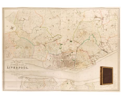
Liverpool. Bennison (Jonathan), A Map of the Town and Port of Liverpool with the Environs including Seacomb, Woodside, Birkenhead, Tranmere &c. from actual survey, Liverpool, Sept. 1835, large folding map, engraved by John Dower, contemporary outline colouring, sectionalised and laid on later linen, calligraphic cartouche, compass rose and table of reference, slight offsetting, blind stamped endpapers, 1280 x 1780 mm, contained in a contemporary morocco gilt book box with ornate gilt spineQTY: (1)
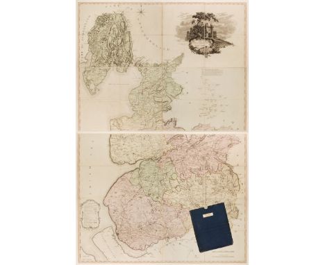
Lancashire. Yates (William), The County Palatine of Lancaster..., 1st edition, 1786, large scale map, engraved by Thomas Billinge, contemporary wash colouring, sectionalised with linen strips behind the joints, on two sheets, large uncoloured decorative cartouche, system of triangulation diagram, compass rose and table of explanation within a floriate cartouche, each sheet approximately 1040 x 1350 mm, contained within card slipcase (with a second edition label to the upper cover), worn and frayed and crudely repaired QTY: (1)NOTE:One of the rarest eighteenth-century county surveys; the first map of the county on a large scale and for which Yates received the Gold Medal from the Society of Arts. The second edition was published by William Faden in 1800 and is equally scarce.

A Late 19th/early 20th century boxwood and brass clinometer rule by Stanley with inset magnetic compass, screw action protractor hinge divided to one degree with rise in inches per yard scale under, spirit level to one edge, marked 'W.F. Stanley Great Turnstile Holborn' with tables of distances, angles and thickness, 16«cm. when closed, in original leather covered case with instructions.
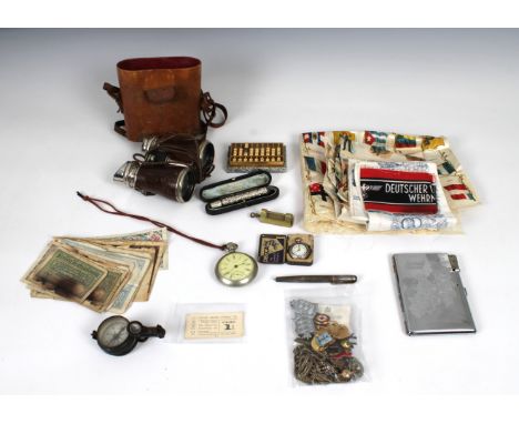
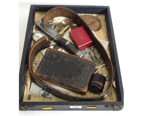
A rummage tray of Militaria and other collectables etc to include a WW2 German Deutscher Volkssturm Wehrmacht Armband; Germany British Zone cigarette case light combination; Waltham pocket watch; compass; pair of field glasses; collection of various pin badges etc, to include Guernsey, Red Cross, Ancient Order of Foresters, English Folk Dance Society; Guernsey Railway tickets; Worldwide banknotes; British Great War silk handkerchief with Regimental badges and others; silver retractable pen / knife, etc. (quantity)
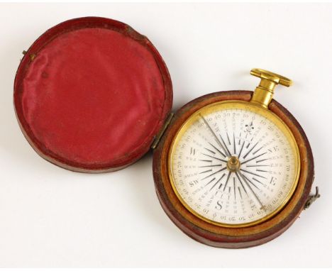
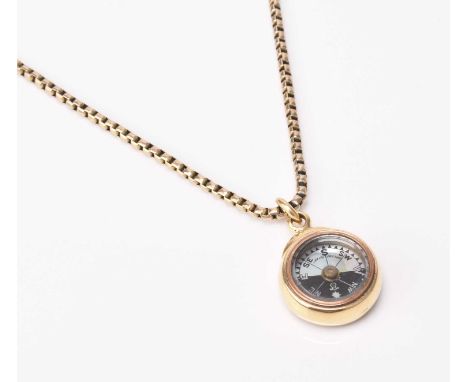
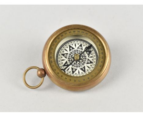
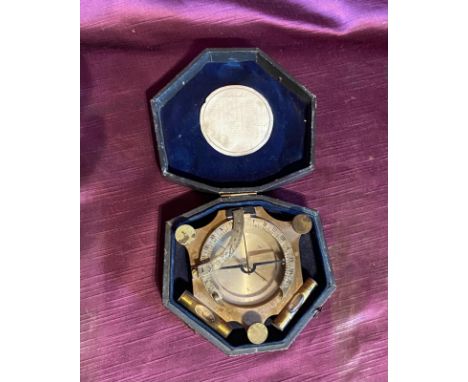
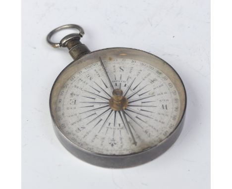
A Dollond of London gilt brass pocket compass, the signed enamel dial with thirty-two point rose, steel needle, suspension loop, 5.3cm diameter, within a Moroccan leather case CONDITION REPORT:The compass appears to be in working order, indicating north in line with google maps. The back of the case shows an indistinct incised inscription dated '1842'. The brass case shows wear and fine surface scratching commensurate with age and use. The case appears to be original to the compass and shows scuffs, wear and fading commensurate with age and use.
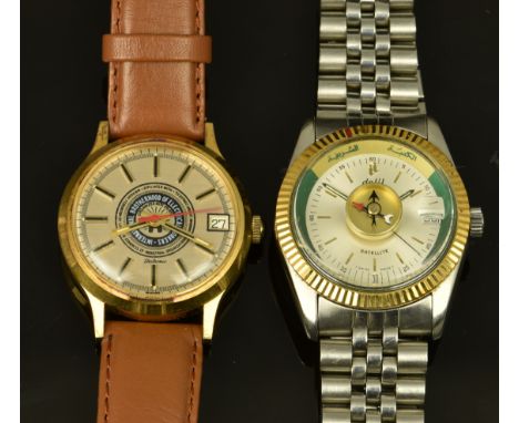
Two gentleman's wristwatches, one for the International Brotherhood of Electrical Workers with date aperture, two-tone hands and baton hour markers, silver dial and electronic movement, on brown leather strap, the other Dalil Satellite with compass, date aperture, luminous hands, gold hour markers, silver dial, gold bezel and stainless steel case, on stainless steel bracelet, case diameter 35mm.

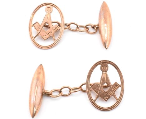
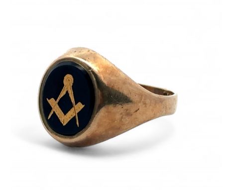
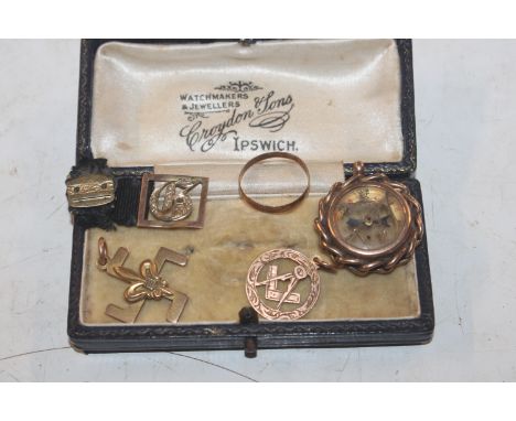
A pair of 9ct gold Masonic cufflinks. The chain style cufflinks having pierced oval heads with Masonic square and compass iconography to cable link chain and torpedo versos. Partially hallmarked 9ct to verso. Sponsor's mark EAP. Measures 1.4cm x 1.8cm x 3cm. Weighs 4.06g. All weights, measurements and sizes are approximate.
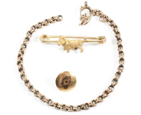
A collection of gold and rolled gold jewellery. The lot to include a safety pin brooch with a rolled gold terrier dog, unmarked. A rolled gold chain bracelet with replacement 9ct gold spring ring clasp, chain unmarked and tests as rolled gold and spring ring marked 9K. The lot to also include a rolled gold Masonic stud button with pierced square and compass, unmarked. Dog brooch pin measures 4cm x 1.2cm. Masonic stud button measures 1.2cm x 1.2cm. Bracelet measures 19cm. Total weight 9.34g. All weights, measurements and sizes are approximate.
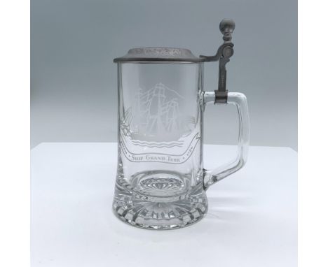
Clear glass beer mug featuring an etching of galleon and a banner marked: Salem, Ship Grand Turk, 1786. Compass embossed on the top of the pewter hinged lid. Alwe embossed on the bottom of the glass. Old Spice and W. Germany impressed on the side of the pewter shank. Dimensions: 5.25"L x 4"W x 7.25"HManufacturer: AlweCountry of Origin: GermanyCondition: Age related wear.
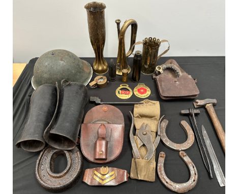
WW1 British Folding Saw in pouch dated 1918, no handles: Trench Art vase and jug: Brass Bugle, Horse shoes and horse shoeing kit: repro compass, leather riding gaiters, Cpl's leather rank brassard, shell case, No 4 Bayonet, Post War British steel helmet no liner, etc. Provenance: The private collection of Bradbury, deceased, and formerly contained in their private Museum at Clay Cross.


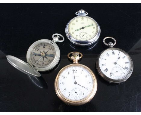
A BOX OF ASSORTED ITEMS, to include a fiddle pattern silver spoon, hallmarked London 1834, a silver medal, hallmarked Birmingham 1928, approximate gross weight 59.7 grams, a silver and mother of pearl fruit knife, hallmarked Sheffield, a single yellow metal hoop earring, a compass, a 'Sekonda' wristwatch, assorted clock faces and other assorted items (condition report: general moderate wear, watch case back is not secure, watches and clocks have not been tested for working condition, we cannot guarantee the working condition of the watch or clocks)
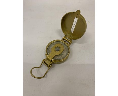
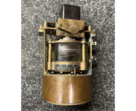
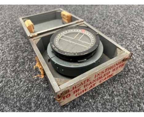
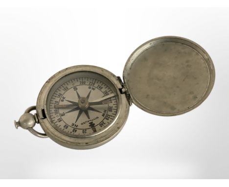
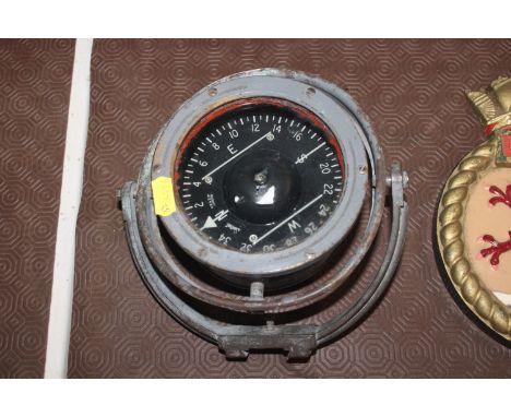
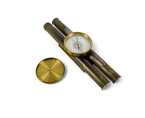
H.Hughes and Son London, gimball compass, 13cm (dia) / All lots are located at The Barn, Hampstead Farm, Nr Henley on Thames, Oxfordshire, RG9 4LG. Regretfully Wellers are unable to offer any type of shipping, please see our important information for courier recommendations and collections information.
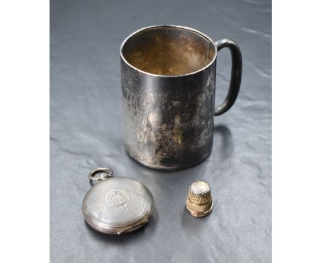
An Edwardian silver cup, of traditional form having engraved 'JCW May 21st 1910', marks for Birmingham 1908, maker Joseph Gloster Ltd, sold along with a Victorian silver cased compass, marks for London 1890, and a Elizabeth II silver commemorative thimble for the coronation of Elizabeth II, 183g gross
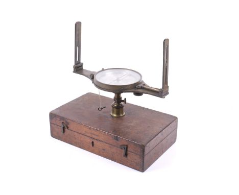
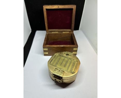
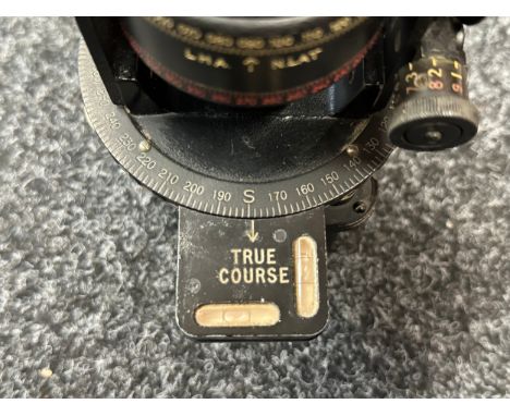
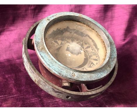
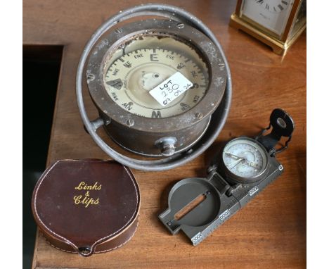
A 19th century T.B. Winter Surveyor's Compass. The engraved and silvered dial marked 'T.B. Winter, Newcastle upon Tyne', Diameter 14.5cm, the gimbal compass and single spirit level attached to a cast metal folding frame, within a fitted box with label, 38cm long Condition Report: Appears to be function as a compass, not tested for accuracy, the metal work is tarnished conducive with age, glass levels are undamaged, there are a few small dents and marks to the metal work frame. Its wooden box is very marked and worn, its interior is in poor condition.
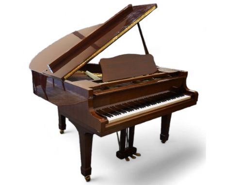
Yamaha - Baby Grand piano in mahogany polyester finish case, G1 model, serial No 4741647, cast overstrung frame with 88 keys and seven octave compass, original stringing, tuning pins, hammers, dampers and felts, sostenuto, una corda and sustain pedals, with a solid music desk and tapered legs on brass castors. Dimensions: Length/Width: 144cm Depth/Diameter: 156cm
-
36562 Los(e)/Seite