

Amerique Septentrionale Divisee en ses Principales Parties, ou sont Distingues les uns des Autres les Estats This beautiful map of the Americas shows California as an island in the style of the second Sanson model (1656) with the indented northern coastline. A small peninsula Agubela de Gato is the only part of the Pacific coastline shown north of California. A strip of Terre de Jesso is shown in the Pacific immediately west of northern California. Santa Fe is shown along the R. del Norte (Rio Grande River), but the river erroneously drains into the Gulf of California. The two western Great Lakes are open-ended, and Lake Erie is too far south, split by the 40th parallel. Politically the map shows the British colonies confined to the Eastern Seaboard and extending south only to a large Virginia. The Carolinas are labeled Floride Francoise and both New Sweden (N. Suede) and New Amsterdam are shown. The large Louisiana region is labeled Floride and is shown as a Spanish possession. Beautifully engraved by Cordier. This is a slightly reduced version of his map of 1674. It can be distinguished from the early version by the size and location of the distance scale. It is also dedicated to the French King rather than to the Dauphin. This is a rare variant of Burden`s second state with the imprint showing the number 168 (rather than 169, believed to be a partial date) in the distance scale cartouche. Original outline color (with later coloring in the cartouches) on watermarked paper with a professionally repaired centerfold separation that enters less than 1"" into map at bottom. 18.1 W x 25.5 H Sanson/Jaillot, 1698
629120 Preisdatenbank Los(e) gefunden, die Ihrer Suche entsprechen
629120 Lose gefunden, die zu Ihrer Suche passen. Abonnieren Sie die Preisdatenbank, um sofortigen Zugriff auf alle Dienstleistungen der Preisdatenbank zu haben.
Preisdatenbank abonnieren- Liste
- Galerie
-
629120 Los(e)/Seite

Amerique Septentrionale Dressee sur les Relations les Plus Modernes des Voyageurs et Navigateurs, ou se Remarquent les Etats Unis Handsome chart of North America that adds several new elements including I. Shelrock, the Bermudas, and most importantly delineates the new United States. It also improves the configuration of the Great Lakes after d`Anville (originally drawn on the Bellin model). The large inset ""Partie Nord-Quest de l`Amerique"" shows the northwest region with much of the mythical cartography of the day including Lake de Fonte (Sea of the West) and the River of the West flows to the Pacific from a large salt lake, Tahuglauks. The decorative title cartouche balances the inset in the opposite upper corner.This is an unrecorded state that is obviously later than State 6 as given by Pedley. In this example the line of text ""Publiee en 1750 et Corrigee en 1783"" which is directly above ""Par le S. Robert de Vaugondy, Geographe"" in State 6 has been completely removed. A nice example on thick hand laid paper with wide margins. There is a centerfold split at bottom that has been repaired on verso, as well as some foxing marks and soiling in the top and bottom blank margins. In the Atlantic are some minor physical score marks which are not distracting. 19 W x 23 H Robert de Vaugondy, Didier 1783
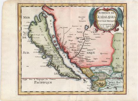
Audience de Guadalajara, Nouveau Mexique, Californie, &c. This map was first published in 1656 and introduced the so-called second Sanson model of California as an island. This depiction shows a small peninsula (Agubela de Cato) above the island, two bays along the island`s northern coast and two new place names, Tolaago and R. de Estiete. Sanson actually based this on information from the less well known map by Luke Foxe, but it was this map that influenced many other cartographers throughout the rest of the century. On the mainland there are new Indian tribes identified in the region of the R. del Norte, which flows southwest from a large inland lake. This example was published in Joannes Ribbius` very rare Dutch translation of Sanson`s L`Amerique en Plusieurs Cartes. The map was re-engraved for this edition, with only very minor differences from Sanson`s map of 1657. This is the first state of the Ribbius edition, prior to the addition of a grid of longitude and latitude. A nice impression on watermarked paper with attractive color. 7.9 W x 9.3 H Sanson, Nicolas 1683

New Mexico vel New Granata et Marata et California This copper-engraved map is on a full sheet (6.3 x 7.9"") with related English text below and on verso. It depicts California as an island on the second Sanson model with the addition of C de la Trinidad and P. California along the southern edge of the island. The Rio Grande is correctly shown flowing into the Gulf of Mexico while most maps of its time showed the river emptying into the Gulf of California. This is the first state of the map with page number 585 at upper right. Published in John Seller`s Geography Rectified. Watermarked paper with faint text show-through in the image, else fine. 4.4 W x 5.1 H Morden, Robert 1688

Africa A reduced version of Hondius` superb map of the continent. It is based on the Mercator model with revisions to the coastlines, particularly that of Madagascar. Hondius improved the Cape area by inserting C. Falco and discarding Cayneca. In western Africa, the Niger River flows in a fairly straight line to the Atlantic, and two large lakes south of the equator are shown as the source of the Nile River. The map is crisply engraved and decorated with strapwork title and distance scale cartouches. Latin title page on verso, published in the first edition. Light, overall toning. 3.8 W x 5.3 H Hondius/Bertius, 1616

Appendix Tab. III. Africae, Aegyptum Inferiorem Exhibens... Lovely map of the Nile delta based on the Ptolemaic model. Mercator originally published this map in his 1578 edition of Ptolemy`s great Geography. Although he is most renowned today for the projection he popularized and for first using the term Atlas for a collection of maps, he devoted much of his life to his Ptolemaic maps. The maps were beautifully engraved as nearly as possible to their original form and embellished with fine cartouches. This map includes two sailing ships in the stipple engraved sea. A nice impression on watermarked paper with wide, original margins. There are a few minor damp stains along sheet edges. 9.7 W x 14.4 H Ptolemy/Mercator, 1698
A stainless steel Tudor Oyster wristwatch, model 6420, serial no 53480, on a later expanding bracelet, together with a Rolex box and outer case Crown unscrews. Hands adjust. Winds and ticking but no guarantee given. Glass very scratched. Under 10x magnification dot/marks to the dial. Case scratched. Later bracelet very worn. Box and guarantee issued in 1984 when bought as a pre-owned watch.

Longines Christrobal Special Edition gentleman`s stainless steel wristwatch, ref. 5253, cal. 2892-2 with rhodium 21 jewel movement, circa 1992, 40mm, with box, papers and commemorative Santa Maria glass model ship in a bottle (as new) *Made in 1992 to commemorate the 500th anniversary of the discovery of America by Christopher Columbus in 1492


ROLEX - An Oyster Perpetual Datejust gentleman`s wrist watchchampagne dial, baton numerals, inscribed Superlative Chronometer Officially Certified, gold bezel, screw down winder, gold and stainless steel bracelet, model 1061, serial number 2638618, 1968 productionWidth of watch head: 33mm


An American Hamilton two day marine chronometer, signed Hamilton Watch Company Lancaster, PA. USA, model 22, in a mahogany case with plated fittings, the silver dial with subsidiaries for seconds and 48 hour up/down power reserve. The underside bearing the inscription TD Watch, Bureau of Ships, US Navy 9079-1943. Case 15cm wide


A 9ct gold gatelink bracelet with a heart shaped padlock clasp, a 9ct gold and cultured pearl pendant with a 9ct gold neckchain, a 9ct gold cased one pound note charm, a 9ct gold cased ten shillings note charm, a carved bone model of a Japanese sword, a group of silver and other jewellery, including an oval hinged bangle with engraved decoration on a snap clasp, a marcasite set circular brooch with a butterfly motif, a marcasite heart shaped pendant locket with a neckchain.

An English gilt brass chronometer carriage timepiece, circa 1970s, the four pillar eight day fusee movement with maintaining power, Earnshaw type detent escapement with freesprung helical balance spring and heavy bimetallic balance, the silvered dial signed `Thomas Mercer`, above black Roman numerals, framing subsidiary seconds and state of wind indicator, the tapering case with swing handle above bevelled glass panels to top, front and sides, the solid rear plate with start/stop lever, hand setting and inscribed `Thomas Mercer, St. Albans, England, Established 1858` above model No. `1172`, on bracket feet, height approx 19cm, with original tooled black leather case and winding key.


A Royal Copenhagen porcelain vase, circa 1954, of baluster form with crackle glazed decoration against a terracotta ground, a Royal Copenhagen model of a frolicking bear, a set of six Royal Copenhagen blue and white coffee cups and saucers, decorated with flowers (minor faults), together with a set of six Meissen Böttger ware coin medallions, early 20th Century, cased (one missing).


-
629120 Los(e)/Seite