628707 Preisdatenbank Los(e) gefunden, die Ihrer Suche entsprechen
628707 Lose gefunden, die zu Ihrer Suche passen. Abonnieren Sie die Preisdatenbank, um sofortigen Zugriff auf alle Dienstleistungen der Preisdatenbank zu haben.
Preisdatenbank abonnieren- Liste
- Galerie
-
628707 Los(e)/Seite


Los 615
†After the Antique: A lead model of the Warwick urn 2nd half 19th century on later composition stone base urn 86cm.; 34ins wide; 130cm.; 51ins high overall The marble original of this urn was discovered in 1771. It was purchased by Sir William Hamilton and sold after restoration to the Earl of Warwick, who for a long time forbade casts to be made of it. Eventually bronze and cast iron replica’s were made and it was copied on a reduced scale in silver, bronze and terracotta by artists using the prints by Piranese. It is perhaps the most famous antique vase after the Medici and Borghese urns. By repute, it headed a list of art treasures compiled by Napoleon Bonaparte, to be appropriated after the conquest of Great Britain.
![[Lot of 5] Nova Orbis Tabula, in Lucem Edita [and] Novissima et Accuratissima Septentrionalis ac Meridionalis Americae Descr](http://lot-images.atgmedia.com/SR/36385/2906594/9-201458131834_468x382.jpg)
Los 9
[Lot of 5] Nova Orbis Tabula, in Lucem Edita [and] Novissima et Accuratissima Septentrionalis ac Meridionalis Americae Descriptio... [and] Totius Africae... [and] Accuratissima Totius Asiae Tabula... [and] Nova et Accurate ... Europae Descriptio This is a matching set of maps of the world and continents by noted Dutch map publisher, Frederick de Wit. Size varies slightly. A. Nova Orbis Tabula, in Lucem Edita. This is one of the most attractive double-hemispherical world maps of the late seventeenth century. The corners are filled with images of the seasons, the zodiac, and the elements, all combined within four well-composed vignettes. At top left is a personification of Spring, who also represents Virgo, with the element of Air billowing her robes. The bull of Taurus and the ram of Aries are shown to the right. The top right vignette represents Autumn, with the shore in the background illustrating the element Water. A putti holds a crab representing Cancer, and another holds the lion of Leo. The twins of Gemini flank the inset of the North Pole at top. The lower left scene presents Summer and Earth with a wine-imbibing Bacchus and a scene of drunkenness The signs for Scorpio and Libra are held by two followers, while Sagittarius gallops in the background. Winter holds court in the final vignette, with the element of Fire shown to the left. Aquarius is represented by a child pouring water into a basin. A group of raucous children in the background hold a goat representing Capricorn and a fishing pole with the double fish of Pisces. In North America, the Great Lakes appear as one large semi-circle with an open western end, and the island of California is shown on the Briggs model with a flat northern coast, and a portion of Anian appears in the Pacific Northwest. South America has the mythical L. Parime astride the equator, with the imaginary golden city of Manoa on its shores. Asia displays a Japan with an oversized Iedso (Hokkaido) shown on the map of the Western Hemisphere. A partial coastline for Australia is shown, and both New Zealand and Tasmania are indicated by only one stretch of coastline. The inset of the North Pole shows Hudson Bay with two southern bays, and the inset of the South Pole is nearly blank save for the very tip of South America and Tierra del Fuego. This is the second plate with cherubs in the cusps and the appearance of Nova Guinea and Quiri Regio in the western hemisphere. Ref: Shirley #451. Condition: There are some stains in the southern hemisphere, a few minor creases, and a professionally repaired 1"" tear east of Brazil.B. Novissima et Accuratissima Septentrionalis ac Meridionalis Americae Descriptio, Multis Locis Recentibus Aucta et Correcte Divisa in Omnes Partes Hodiernas. This is the seventh state of this great map of the Americas, originally engraved circa 1675, and updated with the addition of New Guinea, the Solomon Islands, and Quiri Regio, Fretum Aniani and Terra Esonis. While the decorative features follow Visscher, the cartography is largely based on Sanson. California is an Island, the Great Lakes are open-ended in the west, and the R. del Norte flows from a large western lake and empties into the sea between the mainland and California, labeled Mare Vermio. In South America, the mythical lakes of Parime Lacus and Xarayes are shown, along with vignettes of a battle scene and a village in the Brazilian interior. The pictorial title cartouche contains scenes of gold panning, hunting and a native chief standing beneath an umbrella. The only change De Wit made was that the chief is standing on the left rather than on the right as in Visscher`s composition. The top cartouche depicts angels struggling with a devil for the soul of a Native American. Ref: Burden #465; McLaughlin #49, Tooley (America) p.120 #33. C. Totius Africae Accuratissima Tabula, Denuo Correcte Revisa, Multis Locis Aucta, in Partes tam Maiores quam Minores Divisa. The information contained in this beautiful map of the African continent is typical of the late 17th Century. The Nile appears according to the ancient pattern of Ptolemy, arising from the two lakes of Zaire and Zafflan. De Wit`s depiction of the southeastern coast includes numerous deep inlets and several rivers and lakes at the southern tip not seen on other maps of the period. The kingdom of Monomotapa extends as far south as the Rio de Infante and there are few names in the interior of the Cape. The fictitious N. I. de Sta. Helena appears in the South Atlantic. The interior is decorated with elephants, ostriches, monkeys, lions and rhinoceros, and seven small ships sail in the oceans. The well-engraved title cartouche features Moors and Africans with a child seated on an elephant and two lions perched atop the cartouche. This popular map was copied by several other cartographers including Danckerts and De Ram. This is the fifth state. Ref: Betz #114.5; Norwich #48. Condition: There is a professionally repaired tear that enters 2"" into cartouche at bottom, and a few tiny abrasions.D. Accuratissima Totius Asiae Tabula in Omnes Partes Divisa, de Novo Correcta, ac in Lucem Edita. This handsome, large map of the continent and East Indies shows the extent of European knowledge of the region. It is vividly rendered with good detail throughout the south and south east, due to the surveys of the Dutch East India Company, while northern and central Asia is filled mostly with mountains, deserts and forests. The work of the Jesuit missionaries is reflected in the well-documented region of China. The large title cartouche includes a busy scene including traders with their exotic cargo. Ref: Yeo #59. Condition: There is a professionally repaired tear that extends from the centerfold to the Black Sea, and a chip in the bottom left corner has been repaired, with image expertly replaced in facsimile.E. Nova et Accurate Divisa in Regna et Regiones Praecipuas Europae Descriptio. Finely engraved large map of Europe with the characteristic detail of this prominent Dutch cartographer. It is richly ornamented with a variety of ships sailing the seas, a compass rose, a sea monster, Europa shown riding Zeus in the form of a bull, and several putti holding the title banner aloft. Condition: Several tears adjacent to the centerfold (between 1"" and 2"" in length) have been archivally repaired. There are a few small abrasions, and some small chips and tears in blank margins have also been archivally repaired. There are some bluish shadows that appear throughout the map that are caused by our scanner, and do not appear on the map. All maps are in full original color on watermarked paper with light to moderate soiling, and professionally repaired centerfold separations at bottom. See description above for additional details. 19.2 W x 22.7 H Wit, Frederick de 1690

Los 64
Nouveau Continent avec Plusieurs Isles et Mers This is the second of three similar miniature maps of the Americas drawn in a hemispheric projection in Description de l`Univers. California is depicted as an island on the Briggs model, with a flat northern coast. The Solomon Islands dominate the Pacific, and part of the New Zealand coast is shown but not named. Two minutely engraved galleons decorate the map. Page number 235 in upper right corner and French text on verso. On watermarked paper with minor toning and soiling in the blank margins. 5.8 W x 4.1 H Mallet, Alain Manesson 1683

Los 66
Carte Tres Curieuse de la Mer du Sud, Contenant des Remarques Nouvelles et Tres Utiles Non Seulement sur les Ports et Iles de Cette Mer... This spectacular wall map is richly engraved in the tradition of Dutch cartography. Although the focus of the map is the Americas, it extends to include all of the Pacific with the East Indies and Japan, and all of the Atlantic with a good deal of western Europe and Africa. The map is based on De Fer`s map of 1713 and appeared in the sixth volume, devoted to the Americas, of Chatelain`s monumental work, Atlas Historique. California is shown as an island on the second Sanson model with an indented northern coast, numerous place names, and a notation alluding to the controversy provoked by Father Kino`s map of the peninsular form. As such, this was one of the first European maps to question the myth of the island of California.The Great Lakes are well defined in North America, which is devoid of geographic detail with the exception of major rivers and a few place names, including a few missions and forts. The unknown northern reaches of the continent are cleverly hidden with notes and decorative medallions, and the northeastern US and Quebec appear quite elongated. In the South Pacific are other newly discovered lands, including the Solomon Islands positioned south of California, several partially delineated islands labeled ""land seen but unknown,"" and the incomplete coastlines of Australia, New Zealand, and Tasmania.Above North America are 9 medallions depicting explorers notable for their voyages to the New World, including Columbus, Vespucci, Magellan, Le Maire, Drake and Dampier. The tracks of these explorers are traced throughout the oceans along with depictions of their ships. The map is filled with vignettes enclosed in rococo borders providing a panorama of the New World and illuminating key geographical locations, the native culture, and indigenous flora and fauna. The waters throughout the southern hemisphere feature inset maps and town plans, including the Mississippi Delta, the Isthmus of Panama, the Rio de la Plata, Acapulco Bay, Mexico City, Havana, and Veracruz. The vignettes include a spectacular view of Niagara Falls with the famous depiction of a beaver colony, a scene of the cod fisheries in Newfoundland, Native Americans hunting, and the rituals of the Aztecs and Incas including human sacrifice, mining and sugar operations in South America. The insets are surrounded by images of animals and plants native to the New World, such as an opossum, a muskrat, a tobacco plant, and a pineapple.On four sheets, joined. One of the most spectacular maps of the Americas ever published. An extremely fine, dark impression and superb color with folds, as issued. There are a few faint and unobtrusive spots and minor extraneous creases. This is an exceptional example. 32.1 W x 55 H Chatelain, Henry Abraham 1719

Los 76
Amerique Septentrionale Divisee en ses Principales Parties, ou sont Distingues les uns des Autres les Estats This beautiful map of the Americas shows California as an island in the style of the second Sanson model (1656) with the indented northern coastline. A small peninsula Agubela de Gato is the only part of the Pacific coastline shown north of California. A strip of Terre de Jesso is shown in the Pacific immediately west of northern California. Santa Fe is shown along the R. del Norte (Rio Grande River), but the river erroneously drains into the Gulf of California. The two western Great Lakes are open-ended, and Lake Erie is too far south, split by the 40th parallel. Politically the map shows the British colonies confined to the Eastern Seaboard and extending south only to a large Virginia. The Carolinas are labeled Floride Francoise and both New Sweden (N. Suede) and New Amsterdam are shown. The large Louisiana region is labeled Floride and is shown as a Spanish possession. Beautifully engraved by Cordier. This is a slightly reduced version of his map of 1674. It can be distinguished from the early version by the size and location of the distance scale. It is also dedicated to the French King rather than to the Dauphin. This is a rare variant of Burden`s second state with the imprint showing the number 168 (rather than 169, believed to be a partial date) in the distance scale cartouche. Original outline color (with later coloring in the cartouches) on watermarked paper with a professionally repaired centerfold separation that enters less than 1"" into map at bottom. 18.1 W x 25.5 H Sanson/Jaillot, 1698

Los 87
Amerique Septentrionale Dressee sur les Relations les Plus Modernes des Voyageurs et Navigateurs, ou se Remarquent les Etats Unis Handsome chart of North America that adds several new elements including I. Shelrock, the Bermudas, and most importantly delineates the new United States. It also improves the configuration of the Great Lakes after d`Anville (originally drawn on the Bellin model). The large inset ""Partie Nord-Quest de l`Amerique"" shows the northwest region with much of the mythical cartography of the day including Lake de Fonte (Sea of the West) and the River of the West flows to the Pacific from a large salt lake, Tahuglauks. The decorative title cartouche balances the inset in the opposite upper corner.This is an unrecorded state that is obviously later than State 6 as given by Pedley. In this example the line of text ""Publiee en 1750 et Corrigee en 1783"" which is directly above ""Par le S. Robert de Vaugondy, Geographe"" in State 6 has been completely removed. A nice example on thick hand laid paper with wide margins. There is a centerfold split at bottom that has been repaired on verso, as well as some foxing marks and soiling in the top and bottom blank margins. In the Atlantic are some minor physical score marks which are not distracting. 19 W x 23 H Robert de Vaugondy, Didier 1783
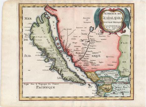
Los 310
Audience de Guadalajara, Nouveau Mexique, Californie, &c. This map was first published in 1656 and introduced the so-called second Sanson model of California as an island. This depiction shows a small peninsula (Agubela de Cato) above the island, two bays along the island`s northern coast and two new place names, Tolaago and R. de Estiete. Sanson actually based this on information from the less well known map by Luke Foxe, but it was this map that influenced many other cartographers throughout the rest of the century. On the mainland there are new Indian tribes identified in the region of the R. del Norte, which flows southwest from a large inland lake. This example was published in Joannes Ribbius` very rare Dutch translation of Sanson`s L`Amerique en Plusieurs Cartes. The map was re-engraved for this edition, with only very minor differences from Sanson`s map of 1657. This is the first state of the Ribbius edition, prior to the addition of a grid of longitude and latitude. A nice impression on watermarked paper with attractive color. 7.9 W x 9.3 H Sanson, Nicolas 1683

Los 311
New Mexico vel New Granata et Marata et California This copper-engraved map is on a full sheet (6.3 x 7.9"") with related English text below and on verso. It depicts California as an island on the second Sanson model with the addition of C de la Trinidad and P. California along the southern edge of the island. The Rio Grande is correctly shown flowing into the Gulf of Mexico while most maps of its time showed the river emptying into the Gulf of California. This is the first state of the map with page number 585 at upper right. Published in John Seller`s Geography Rectified. Watermarked paper with faint text show-through in the image, else fine. 4.4 W x 5.1 H Morden, Robert 1688

Los 670
Africa A reduced version of Hondius` superb map of the continent. It is based on the Mercator model with revisions to the coastlines, particularly that of Madagascar. Hondius improved the Cape area by inserting C. Falco and discarding Cayneca. In western Africa, the Niger River flows in a fairly straight line to the Atlantic, and two large lakes south of the equator are shown as the source of the Nile River. The map is crisply engraved and decorated with strapwork title and distance scale cartouches. Latin title page on verso, published in the first edition. Light, overall toning. 3.8 W x 5.3 H Hondius/Bertius, 1616

Los 687
Appendix Tab. III. Africae, Aegyptum Inferiorem Exhibens... Lovely map of the Nile delta based on the Ptolemaic model. Mercator originally published this map in his 1578 edition of Ptolemy`s great Geography. Although he is most renowned today for the projection he popularized and for first using the term Atlas for a collection of maps, he devoted much of his life to his Ptolemaic maps. The maps were beautifully engraved as nearly as possible to their original form and embellished with fine cartouches. This map includes two sailing ships in the stipple engraved sea. A nice impression on watermarked paper with wide, original margins. There are a few minor damp stains along sheet edges. 9.7 W x 14.4 H Ptolemy/Mercator, 1698
Los 1260
A stainless steel Tudor Oyster wristwatch, model 6420, serial no 53480, on a later expanding bracelet, together with a Rolex box and outer case Crown unscrews. Hands adjust. Winds and ticking but no guarantee given. Glass very scratched. Under 10x magnification dot/marks to the dial. Case scratched. Later bracelet very worn. Box and guarantee issued in 1984 when bought as a pre-owned watch.

Los 125
Longines Christrobal Special Edition gentleman`s stainless steel wristwatch, ref. 5253, cal. 2892-2 with rhodium 21 jewel movement, circa 1992, 40mm, with box, papers and commemorative Santa Maria glass model ship in a bottle (as new) *Made in 1992 to commemorate the 500th anniversary of the discovery of America by Christopher Columbus in 1492


Los 7
An American Hamilton two day marine chronometer, signed Hamilton Watch Company Lancaster, PA. USA, model 22, in a mahogany case with plated fittings, the silver dial with subsidiaries for seconds and 48 hour up/down power reserve. The underside bearing the inscription TD Watch, Bureau of Ships, US Navy 9079-1943. Case 15cm wide


Los 589
A 9ct gold gatelink bracelet with a heart shaped padlock clasp, a 9ct gold and cultured pearl pendant with a 9ct gold neckchain, a 9ct gold cased one pound note charm, a 9ct gold cased ten shillings note charm, a carved bone model of a Japanese sword, a group of silver and other jewellery, including an oval hinged bangle with engraved decoration on a snap clasp, a marcasite set circular brooch with a butterfly motif, a marcasite heart shaped pendant locket with a neckchain.

Los 1115
An English gilt brass chronometer carriage timepiece, circa 1970s, the four pillar eight day fusee movement with maintaining power, Earnshaw type detent escapement with freesprung helical balance spring and heavy bimetallic balance, the silvered dial signed `Thomas Mercer`, above black Roman numerals, framing subsidiary seconds and state of wind indicator, the tapering case with swing handle above bevelled glass panels to top, front and sides, the solid rear plate with start/stop lever, hand setting and inscribed `Thomas Mercer, St. Albans, England, Established 1858` above model No. `1172`, on bracket feet, height approx 19cm, with original tooled black leather case and winding key.


-
628707 Los(e)/Seite