We found 182975 price guide item(s) matching your search
There are 182975 lots that match your search criteria. Subscribe now to get instant access to the full price guide service.
Click here to subscribe- List
- Grid
-
182975 item(s)/page

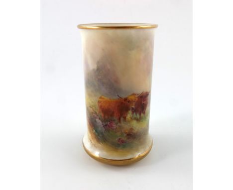
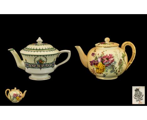
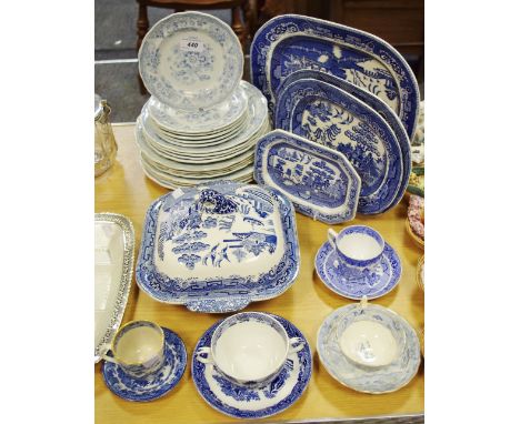
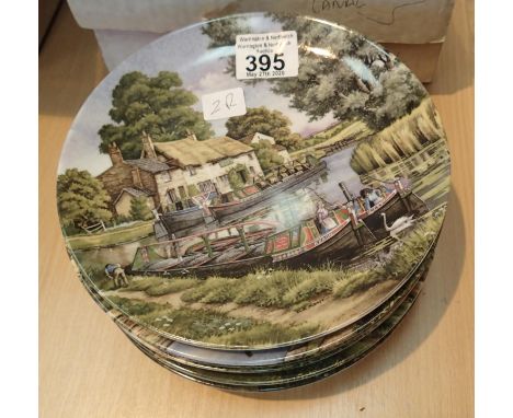
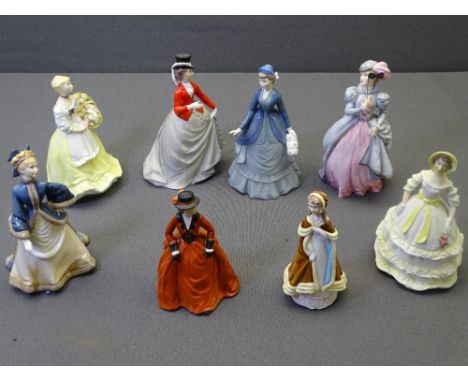
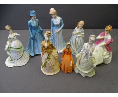
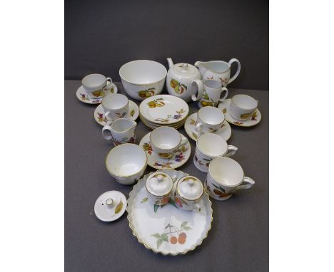
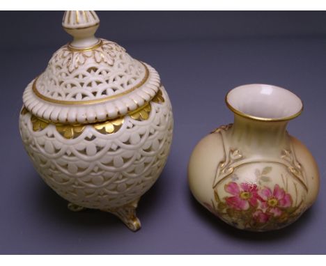
Lot 410
Royal Worcester Hand Painted Blush Ivory Lidded Teapot, Hand Painted Images of Spring Flowers to Body and Lid of Teapot on Ivory Ground. Date 1903. 5 Inches - 12.5 cm High. All Aspects of Condition Is Excellent + A Royal Worcester Nice Quality Hand Painted and Enamelled Lidded Teapot, Highlighted and Decorated in Enamel Fruits ' Apples and Berries ' ' Chalons ' Pattern. Date 1888. 5 Inches - 12.5 cm High. Some Slight Scuff Marks Doesn't Detract. Please See Image.


Lot 159
Bachmann and Replica 00 Gauge Diesel Locomotives, Bachmann 32-775DC EWS maroon Class 37114 'City of Worcester, 32-752 Great Western green Class 57/0 57602 'Restormel Castle', 31-076 BR blue Peak Class 46 045, 32-652DS BR blue Class 44 005 and Replica Railways 11501 BR blue class 45 128, all in original boxes, VG-E, boxes F-VG (5)


Lot 107
Ceramics - a pair of Goebel Artis Orbis Michelangelo vases, boxed; a Coalport Caughley Jug, boxed; a Royal Worcester Lea & Perrins 150th Anniversary collector plate no. 772 of 1000, boxed; a Ringtons Landmark Vase; a salt glaze owl; a Worthington & Green ale jug embossed in relief with cherubs; another larger marked WYE to base; crested ware including a miniature tea service and Billiken The God of Luck; etc. qty
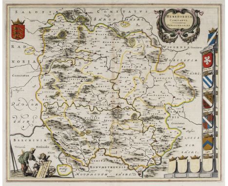
Lot 47
Herefordshire. Blaeu (Johannes), Herefordia Comitatus Hereford-Shire, circa 1650, engraved map with contemporary outline colouring, several repaired marginal closed tears but not affecting image, central fold repaired on verso, 410 x 505 mm, Latin text on verso, together with Saxton (Christopher & Hole W.). Frugiferi AC Ameni Herefordiae Comitatus qui olim pars suit Silurum delineatio, [1637], hand coloured engraved map, slight creasing, 295 x 310 mm, with Speed (John). Worcestershire described, Thomas Bassett & Richard Chiswell, [1676], hand coloured engraved map, inset town plan of Worcester, large strapwork cartouche and mileage scale, central fold strengthened and repaired on verso, slight mount staining and marginal spotting, 385 x 510 mm, English text on verso (Qty: 3)
Lot 494
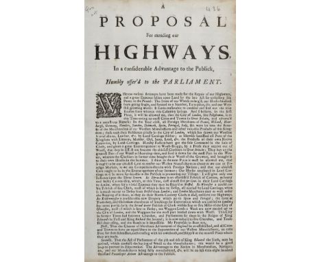
British Highways Broadside. A Proposal for mending our Highways, in a considerable Advantage to the Publick , circa 1710-20, single sheet printed to one side only, caption title, decorative woodcut initial, folio, together with: Broadsides & Tracts , The Case of the Mercers and Traders in the Silk and Woollen Manufactures of this Kingdom. Humbly offered to the Consideration of the Honourable House of Commons, circa 1710-20, single sheet printed to one side with caption title, docket title to verso, folio, The Case of the Woollen Manufacturers, and particularly those of the City of Worcester, with Relation to the Turkey Trade, circa 1710-20, 3,[1]pp., caption title and docket title to final page, folio, Observations on behalf of the Bill, for the better Employing the Poor, and Encouraging the Manufactures of this Kingdom, by preventing the clandestine importation of wrought Silks, mix'd with Gold, Silver, or other Materials, [1729], single sheet printed to one side only, caption title, decorative woodcut initial, lower 5cm of gutter margin excised, folio (Hanson 3960) (Qty: 4)NOTESNo institutional locations of the first title found. The first title refers to the Highway Law of 1692, which stated that parish rate payers could be charged up to six pence for every pound of yearly income from land and other real property. The six pence rate represented a 2.5% tax on property income, which was substantial considering there were also parish taxes for poor relief and constables. The broadside also describes the increasingly poor condition of the roads largely due to the transport of wool to London "the irons of our wheels enlarg'd, our horses hindred from growing single, and limited to a number, turn-pikes, etc. and our ways still growing worse: it seems reasonable to consider and find out the true reason from whence this calamity springs. And I believe, in the first place ... that the city of London, like Polyphemus, is at this time eating up most cities and towns in Great Britain" and considers the consequences of movement of goods within the country, "At Shrewsbury is an establish'd Fabrick of Cottens, as heavy and bulky Commodity, which, at this time, cost almost five per cent in their land carriage to London, when for a trivial expence they may be shipp'd at Bristol. At Worcester a considerable fabrick of fine cloth, most of which is sent to Turkey, all carried by land carriage, when it is much nearer to Turkey from Bristol than London; and London merchants may as well order the shipping of it there, as they do their North-Country Cloth at Hull, and save our highways. At Kidderminster a considerable new drapery which go to Spain and Portugal; the same at Tewkesbury, and Cheltenham abundance of stockings for exportation which are carried to London; but more particularly the Stroud water Fabrick of cloth within four or five miles of the city of Gloucester, most of which is sent to Turkey; ten waggon loads a week are now carried up to the city of London, and the waggons for the most part loaded down with wooll". The broadside calls for "all cities and towns to have an equal share in the exportation of our woollen manufactures". The second title concerns the smuggling of Indian silks & textiles into Britain which had a detrimental effect on the British silk & woollen manufacturers.
Lot 656
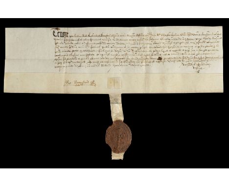
* Adultery: Certificate of Decree, Derby, 1614. Certificate of a decree of Robert Bamford, clerk, MA, official of Christopher Helme, LLD, Archdeacon of Derby; sealed at Derby 25 June 1614, confession before him of Sir John Bentley, knight, of The Priory [Breadsell Priory] near Morley [in Derbyshire], accused and defamed of adultery with a certain Katherine Leigh; the judge enjoined a deserved and salutary punishment on account of his excess of immorality, which he afterwards performed, as more fully appears by a trustworthy certificate enrolled in the Archdeacon’s register, by his penitent face, effusion of tears and other just and lawful causes and considerations; decree dismissing him from any further trouble or judicial process; signed by Robert Bamford and Richard Brandreth, registrar; vellum deed with the red wax seal (chipped with slight loss to edges) of the Archdeaconry of Derby appended, 10 x 32 cm (Qty: 1)NOTESSir John Bentley was the son of Humphrey Bentley of Derby and Clement’s Inn ( Derbyshire Visitation Pedigrees 1569 and 1611 (London, 1895) 7; Baker, The Men of Court 1440-1550 302). Sir John was described as a ‘counsellor at law’ in Glover’s History of Derbyshire (1833), which states that he bought Breadsell shortly after 1597. By that year he had married, as his second wife, Mary Leigh, daughter of Thomas Leigh of Adlington in Cheshire; it is possible that the Katherine Leigh mentioned in the document was his relative by marriage. A personal friend of Sir William Cavendish of Chatsworth, he was knighted in the Royal Garden at Whitehall before the coronation of James I on 23 July 1603 (Shaw’s Knights 1 124). His will of 24 August 1621, including a bequest of the profits of York Castle and its gaol, was proved in the Prerogative Court of Canterbury on 24 May 1622 (TNA PROB 11/139/469). Breadsell was originally a small Augustinian Priory and was later converted to a large Elizabethan house after 1573 by Sir John Bentley. Successive owners have all left their mark on the building, covering the older parts of the building. In 1967 it was bought by the Harper-Crewe family from Calke who sold it for development and it is now a hotel and leisure complex. The most famous resident of Breadsall Priory was the poet, physician and scientist Erasmus Darwin, who lived there for a short time until his death in 1802. Grandfather of Charles Darwin, Erasmus is one of the most remarkable and internationally important figures of the 18th century and is buried in Breadsall church. Christopher Helme of Wiltshire matriculated from Hart Hall, Oxford, aged 18, on 17 December 1576; he was of Merton College when awarded a BA on 23 February 1579, became a fellow in 1580, MA on 18 January 1585 and DCL on 9 July 1594; in 1607 he became rector of Bredon in Worcestershire and Chancellor of the diocese of Worcester; succeeded to the Archdeaconry of Derby in April 1609 and by 1617 had been succeeded by Samuel Clerke. He died in 1628. See Oxford Historical Society 4 273. For letters from Richard Brandreth to Francis Burton regarding search for records relating to lead ore in Dean and Chapter of Lichfield's registry, May 1614, see Derbyshire Record Office D258/7/13/54. A Richard Brandreth, born at Derby c1616, the son of Richard Brandreth, was educated at Repton, matriculated at Christ’s College Cambridge in 1632 and served as headmaster of Derby School, 1652-c1656. Robert Bamford was educated at Brasenose College, Oxofrd (BA 3 February 1574, MA 10 June 1580); see Oxford Historical Society 12 37; he was incorporated at Cambridge in 1600; he served as prebendary of Tachbrook in Lichfield Cathedral, 1597-1629.
Lot 662
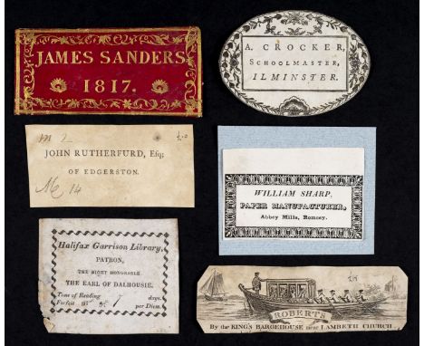
* Bookplates & labels. A collection of 30 bookplates, ownership labels & business cards, etc., 18th & 19th century, including bookplates for Hookham's Circulating Library, New Bond Street, [London]; Halifax Garrison Library, Patron, The Right Honorable the Earl of Dalhousie; A. Crocker, Schoolmaster, Ilminster; Worcester Library, Instituted, 1790; and a masonic bookplate for William Pearce of Birmingham; book ownership labels including: William Rhodes of Derby, 3rd April, 1730; Mr Bill's Library of Bath; Joseph Wood, Deanrow; John Rutherfurd of Edgerston; and a red morocco label for James Sanders, 1817; and business cards & advertising labels including: James Newby, Hat Manufacturer, Dorking, Surrey, c.1790; Peter White, Hat Maker of 81 Newgate Street, London; Academy for Boarding & Day Pupils, No. 1 New Meeting Street, Birmingham, conducted by Wm. Tolley Junr.; Mackay's best Viginia, No. 7. Wych Street, Drury Lane, [London], c.1800; Ruled by T. Pearson's Ruling Machine, c.1790; William Sharp, Paper Manufacturer, Abbey Mills, Romsey; R. Collinson, Printer, Bookseller, Bookbinder & Stationer, Market Place, Mansfield, all contained together in modern ring binder folder (Qty: a folder)
![* British Islands. Mercator (Gerard & Hondius J.). Anglesey, Garnesay, Wight olim vectis [and] Jarsay, [1636], four hand](https://cdn.globalauctionplatform.com/0450faa8-8d79-4719-b091-abb300cb473d/fe0f034c-cac5-4f19-bca4-abb400f7fb28/468x382.jpg)
Lot 7
* British Islands. Mercator (Gerard & Hondius J.). Anglesey, Garnesay, Wight olim vectis [and] Jarsay, [1636], four hand coloured engraved maps on one sheet (as published), overall size 325 x 435 mm, English text on verso, framed and double glazed, together with Drayton (Michael). Title page from the Poly-Olbion, [1612 or later], hand coloured engraved allegorical title page, tipped on to later card, 250 x 160 mm, with Lodge (J.). A Plan of the Navigable Canal from Birmingham in the County of Warwick to the Canal at Aldersley near Wolverhampton..., [and] A Plan of the River Salwarp and of the Navigable Canal from Droitwich to the River Severn in the County of Worcester, published in 'The Gentlemen's Magazine', 1771, two uncoloured engraved canal maps, old folds, 175 x 295 mm and 165 x 350 mm respectively, plus Bowen (Emanuel & Owen John). A Map of Hereford Shire [1720 or later], hand coloured engraved map with an uncoloured strip road map to verso, 185 x 115 mm, mounted (Qty: 5)
Lot 71
Ogilby (John). The Road from London to Aberistwith on the Sea Coast com. Cardigan Wherein are Included the Roads to Oxford and Worcester..., [1675 or later], hand coloured engraved strip road map, ornate decorative cartouche showing a surveyor using a waywiser, central fold partially strengthened on verso, 315 x 445 mm, mounted (Qty: 1)NOTESThe map is sheet no.1 and commences at London and passes through Uxbridge, Beaconsfield, High Wycombe, Stokenchurch and ends at Islip, with an inset road to Oxford.
![Ogilby (John). The Road from the City of Salisbury Com Wilts. to Campden com Gloc. circa 1698 [and] The Continuation of ye Ro](https://cdn.globalauctionplatform.com/0450faa8-8d79-4719-b091-abb300cb473d/4eaf6441-8f93-4309-82e5-abb400fad9bf/468x382.jpg)
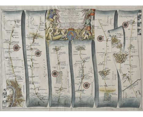
Lot 75
Ogilby (John). The Road from the City of Salisbury Com Wilts. to Campden com Gloc. circa 1698 [and] The Continuation of ye Road from London to Aberistwith, Plate ye Second commencing at Islip com Oxford & Extending to Bramyard com Hereford, two hand coloured engraved strip road maps, both with central folds strengthened on verso, each approximately 325 x 445 mm (Qty: 2)NOTESThe first map is sheet 85 and starts at Salisbury and runs through Everley, Marlborough, Highworth, Lechlade, Burford and Stow-on-the-Wold and ends at Chipping Campden. The second map, sheet 2, starts at Islip and runs through Enstone, Chipping Norton, Moreton-in-Marsh, Pershore and Worcester and ends at Bromyard
Lot 750
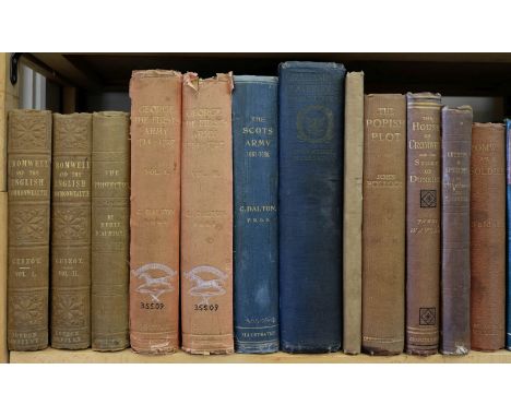
Guizot (François). History of Oliver Cromwell and the English Commonwealth, from the execution of Charles the First to the death of Cromwell, translated by Andrew R. Scoble, 2 volumes, 2nd edition, Richard Bentley, 1854, original blind-stamped cloth gilt, spines lightly faded (otherwise generally in clean condition), 8vo, together with: Dalton (Charles) , George the First's Army 1714-1727, 2 volumes, Eyre and Spottiswoode, 1910, monochrome plates, occasional minor spotting, ex-library copy with ink stamps to both titles, top edge gilt, original red cloth gilt, rubbed and some fraying to joints and head and foot of spine, classification number in black ink and gold ink to foot of spine of each volume, large 8vo, Broadley (A.M.) , The Royal Miracle, A Collection of Rare Tracts, Broadsides, Letters, Prints, & Ballads concerning the wanderings of Charles II after the Battle of Worcester, 1st edition, 1912, monochrome plates, top edge gilt, original red cloth gilt, large 8vo, plus other English Civil War, Restoration, and Scottish Rebellion history and related, mostly 19th and early 20th-century publications, mainly bound in original cloth, 8vo (Qty: 70)
Lot 77
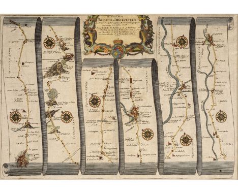
Ogilby (John). The Road from Bristoll to Worcester, The Continuation of the Road from London to Holyhead..., Plate 2 Commencing at Towcester in com. Northton & extending to the City of Lichfield [and] The Continuation of the Road from London to Aberistwith..., plate 3rd and last commencing at Bramyard com Heref. & extending to Aberistwith, circa 1680, together three hand coloured engraved strip road maps, each approximately 315 x 455 mm (Qty: 3)NOTESThe first map commences at Bristol and runs through Dursley, Gloucester and Tewkesbury and ends at Worcester. The second map commences at Towcester and runs through Daventry, Dunchurch, Coventry and Coleshall and ends at Lichfield. The third map commences at Bromyard and runs through Leominster, Prestatyn and Rhayader and ends at Aberystwyth.
-
182975 item(s)/page