Early 19th Century Chinese Famille Rose `European Subject` hunting bowl having typical painted reserve panels depicting hunting and other figures on a foliate ground, 28.5cm diameter At least five vertical hairline cracks coming from the rim and into the well, a further star shaped crack to the well - its points extending across the entire diameter of the well, the interior with a large degree of rubbing to the enamel decoration and all gilding rubbed - ** General condition consistent with age
We found 74924 price guide item(s) matching your search
There are 74924 lots that match your search criteria. Subscribe now to get instant access to the full price guide service.
Click here to subscribe- List
- Grid
-
74924 item(s)/page
THE MEDALS & DIARIES OF BRIG L M BIGGS CVO. DSO. MC & BAR. C.GDS A cased Commander of the Victorian Order (1937). Distinguished Service Order GV. (1919). Military Cross (1917) and Bar 1919. 1914 Star & Bar named to Lt L M Gibbs C.Gds. British War & Victory medal with MID emblem, named to Lt Col L M Gibbs. India General Service Medal 1908 bar Waziristan 1921-24, named to Major L M Gibbs C.Gds. Defence & War medals, 1911 Coronation & 1935 Jubilee medals. 1937 Coronation medal and a 1953 Coronation medal, court mounted for wear . Born at Tyntesfield Bristol in December 1889, the son of Antony and Janet Gibbs of Tyntesfield one of their ten children. Educated at Eton College Lancelot Merival (mothers maiden name) Gibbs was commissioned into the Coldstream Guards in 1910. He served in the European War being wounded, four times mentioned in despatches, and awarded first the Military Cross 1st January 1917. His bar was awarded on the 11th January 1919. His DSO was awarded 3rd June 1919. MID 17/2/15. 1/1/1916. 20/12/1918. 3/6/1919. Citation for his Bar to the Military Cross. Cpt L M Gibbs C Gds att 104th Inf Bgde HQ. For conspicuous gallantry and devotion to duty. When the position on the left flank was very obscure owing to the next division failing to reach its objective he made a daring reconnaissance to gain information and get touch. He collected troops and organised the situation and brought most valuable information to the Brigade. He was under intense fire from machine guns and minenwerfer at close range. MC 1/1/17. Having served in the 3rd Militia Battalion of the Somerset Light Infantry prior to his commission into the C Guards, between 1908-1910. Promoted to Lt in 1913, Captain in 1915, he rose to Lt Colonel (T) before the war ended. A member of the Supreme War Council 1919. He then served on the North West Frontier as ADC to Lord Rawlinson, Commander in Chief India between 1921-25. Commanded the 1st Battalion Coldstream Guards 1930-34. Then A A G The War Office 1934-38. Having retired as a Brigadier in 1938, he became one of His Majesties Hon Corps of Gentlemen at Arms from 1939 onwards. Recalled to serve in WW11 as Brigadier in charge of Administration. London. District until retiring again in 1945. Recalled to the War Office in connection with the Victory March January-July 1946. To enjoy his hobbies of Shooting, Fishing Hunting etc. He resided at Broomham, Catsfield, Battle. Sussex C1950. His original diaries of the Gt War on some 115 sheets of paper, relating to his War Experiences, they amke fascinating reading. Photographs and framed MID Certificates, Commission Documents etc, are with the medals. See Illustration.
A GERMAN HUNTSMANS SIDEARM. A Huntsmans sidearm made by F Horster of Solingen complete with scabbard. White grip with acorns inset, shell guard and acorn quillion, etched hunting scene on both sides of the 13"" blade. Gilt mounts to the hilt, traces of gilt to the brass and leather mounted scabbard.. See Illustration
A PINFIRE 19thC SHOTGUN. A well preserved Pinfire 12B shotgun by the maker C Wagner A Berne in gold letters on the top rib. 29.1/2"" browntwist barrels and high-spur ornate hammers. The action and backplate heavily decorated with hunting scenes and chequered arabesque style designs overall. Underlever break action, steel furniture and sling mounts. See Illustration
GEORGE BIRD GRINNELL AND CHARLES SHELDON (eds): HUNTING AND CONSERVATION ? THE BOOK OF THE BOONE AND CROCKETT CLUB, New Haven Yale University Press, 1925, 31 full page plts compl, (including one fdg), orig cl silvered, spine worn, inner joints split, top bd and spine detached from text block + D JOBSON-SCOTT; BEAGLING, 1934, 2nd impression, orig cl, gt, (2)
A London Underground Map dated June 1973, designed by Paul E Garbutt produced by The Cartographic Department of Hunting Surveys Ltd, approx size 40? x 50? plus a map VISITOR?S LONDON depicting London streets, underground and railway stations, etc, dated 1974 (number 12) printed by Cook Hammond & Kell Ltd, Mitcham & Westminster, approx size 40? x 50?, each, vgc (2)
A collection of assorted hunting prints, comprising 'The Biggest Walls in the Country was in it', 'If there is Paradise on Earth, it was this, it was this, it was this!', together with a print by Hick Cauigton depicting dogs, another depicting horses, one captioned 'Enjoying yourself, Aren't you' depicting a man ploughing a field with two horses in front and planes above, one depicting dogs besides the river and one entitled 'The Albrighton Woodland' from a fine at the Dales, plus one by Pollyana Pickering and many others, mostly mounted and framed, (1 box)
Tabula Magellanica qua Tierrae del Fuego, cum Celeberrimis Fretis a F. Magellano et I. Le Maire Detectis Novissima et Accuratissima Descriptio Exhibetur This is one of the most elaborately decorated maps to focus on the tip of South America with the Strait of Magellan and Le Maire Strait. The coastlines are depicted as very mountainous, while the interior is completely without detail. Instead the region is filled with a hunting scene, exotic birds including rheas and penguins, and a quaint scene of village life. The map is further adorned with a pair of compass roses, three sailing ships, and four beautiful cartouches. The key to the map is in a strapwork cartouche held aloft by putti, while another cartouche at right dedicates the map to Gualtherus de Raet. The cartouches arrayed across the bottom of the map present a unique distance scale in checkerboard format and the title with a tribe of Fuegian natives, penguins and shells. This is the second state with a blank verso. Fine impression and color with minor soiling and a few archivally repaired tears confined to blank margins. 16"" W x 20.5"" H Jansson, Jan 1658
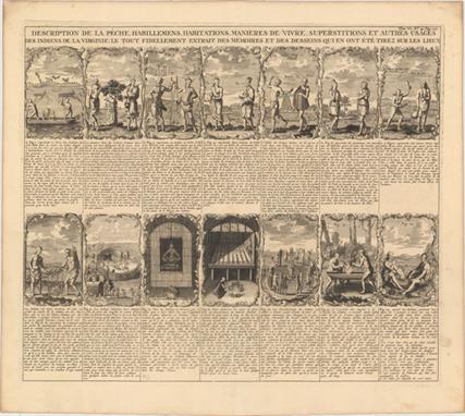
Description de la Peche, Habillemens, Habitations, Manieres de Vivre, Superstitions et Autres Usages des Indiens de la Virginie... An interesting sheet composed of 14 vignettes showing the native Virginians that the first European explorers encountered in the New World, taken from Theodore de Bry`s influential work. Included are ceremonial dances, burial practices, farming, hunting, villages, costumes, etc. Each engraving is accompanied by an explanation in French text. A fine, crisp impression on watermarked paper with minor marginal soiling. 14.5"" W x 17.1"" H Chatelain, Henry Abraham 1719
[On 2 Sheets] Typus Cosmographicus Universalis [with book] Novus Orbis Regionum ac Insularum Veteribus Incognitarum... This striking oval woodcut map of the world was first published in the 1532 edition of Novus Orbis Regionum, an anthology of travel reports published by Simon Grynaeus and Johann Huttich. The work includes a commentary by Sebastian Munster, to whom the map is often attributed due to a statement within his commentary: ""We have found it impossible to indicate the position of all of the regions and all of the islands, because the narrowness of our map did not allow it, and that was not our object."" However, the map bears little resemblance to Munster`s maps of the world and western hemisphere published in 1540. The nomenclature, distribution of land, and geographical depictions are starkly different between this world map and Munster`s other work. It is more likely that Munster`s commentary used the terms ""we"" and ""our"" to reference the collaborative effort of putting together Typus Cosmographicus Universalis, rather than admission of his own efforts related to it. The highly decorative nature of this map is quite unusual for the early 16th century. The masterful engraving of the embellishments has led scholars to believe that the map was designed by Hans Holbein the Younger, who engraved vignettes for Munster and others in Basel between 1528-32.Although the authorship of this map is debatable, its rich artistry is undeniable. The oval projection is surrounded by vignettes depicting various people and fauna from around the world, both real and mythical. At bottom left are the cannibals of South America, with body parts roasting on a spit and hanging from a teepee-like structure. At top left are the Ubangi people of Africa displaying lip plates, a hunted elephant who appears to have captured a human of his own, and winged dragons devouring a horned sheep. At top right is an additional hunting scene along with depictions of several plants. And at bottom right is Lodovico de Varthema, an Italian adventurer, returning to a European seaport to tell of his travels in the Middle East and Asia.However the most fascinating, and revolutionary, decorative elements are the two angels hovering at the north and south poles, turning crank handles to rotate the world on its axis. This concept of keeping the world in motion was innovative in the early 16th century, when it was still believed that the universe revolved around the earth. In fact, Copernicus` ground-breaking and controversial theory of heliocentrism wasn`t published until 1543 in his De Revolutionibus Coelestium. It is possible that the map`s author was aware of Copernicus` principles either by word of mouth or from a brief manuscript edition of Copernicus` Commentariolus, which began circulating around 1529.Within the oval itself are additional embellishments, including a galleon, several dolphin-like sea monsters, and a siren off the eastern coast of Asia.Geographically, the map is antiquated. There are no signs of a southern continent, despite reports from the first circumnavigation of the globe in 1522, led by Magellan. The map generally follows the models of Waldseemuller`s world map of 1507 and Apianus` world map of 1520, showing America as a separate continent between two distinct oceans. However, the map`s author tries to reconcile between Waldseemuller`s map and Columbus` claim that Cuba was not an island by depicting North America with an elongated shape and named Terra de Cuba, and showing only one (rather than two) large islands to the east, yet labeled as both Isabella (Cuba) and Spagnolla (Hispaniola). To the north is Terra Cortesia, a representation of Newfoundland. Another interesting aspect is the representation of Japan, Zipangri, which is shown closer to North America than to Asia.The map is accompanied by the 1537 edition of the Novus Orbis Regionum, in which the map was originally published but has since been removed. The work includes accounts of the expeditions of Columbus, Vespuccio, Marco Polo, and Varthema, among others. Small folio, 598 pp. Bound in full vellum (not original) with title stamped on spine and new endpapers. The map is clean and bright with wide, original margins. The left-hand sheet has professional repairs to one small and three tiny worm holes along the centerfold, with a minute amount of image replaced in facsimile. The right-hand sheet has a centerfold separation that enters 1/2"" into image at left and has been professionally repaired. The text is also clean and bright with very minor soiling. Sebastian Munster`s name has been blacked out in old manuscript ink in the table of contents and his commentary section, causing a hole in the title page at top. The title page has several old ink notations. The hinges are starting and the covers are heavily worn, with the vellum beginning to detach from the covers. Please note that the image of the map as a whole is a composite image - the two sheets are not joined. 14.5"" W x 22.5"" H Munster, Sebastian 1537
-
74924 item(s)/page


![[On 2 Sheets] Typus Cosmographicus Universalis [with book] Novus Orbis Regionum ac Insularum Veteribus Incognitarum... This](http://lot-images.atgmedia.com/SR/36385/2916721/7-2014116145130_468x382.jpg)


