

Atlas Novus sive Tabulae Geographicae Totius Orbis Faciem, Partes, Imperia, Regna et Provincias... This bold title page centers on a large globe positioned on the eastern hemisphere that supports the allegorical figure of Europa, with Asia, Africa and America seated beside the globe. Surrounding the title are the mythical figures of Mercury, Minerva and Mars, each holding a map. In the background, Neptune floats in the sea, while putti fly overhead holding a torch and a dove, symbolizing the conflicting nature of war and peace. Original color with several light damp stains and a small abrasion on Mars` arm. Two chips in the right blank margin have been repaired with old paper, with a minor amount of the neatline replaced in facsimile. 19.6"" W x 11.4"" H Seutter, Matthias 1728
We found 45705 price guide item(s) matching your search
There are 45705 lots that match your search criteria. Subscribe now to get instant access to the full price guide service.
Click here to subscribe- List
- Grid
-
45705 item(s)/page
![[Lot of 4] Amerique [and] Afrique [and] Asie [and] Europe Each map from this matching set of continents is flanked by panels](http://lot-images.atgmedia.com/SR/36385/2916721/6-2014116144830_468x382.jpg)
[Lot of 4] Amerique [and] Afrique [and] Asie [and] Europe Each map from this matching set of continents is flanked by panels of French text describing the continent. The maps and text are surrounded in beautifully engraved rococo borders, printed from a separate plate. Overall dimensions given; maps each measure approximately 9.5 x 11"". Louis Charles Desnos (1725-1805) was an important instrument, globe and map maker in Paris during the eighteenth century. In addition to his publishing work aimed at the French market, Desnos also held the position of Royal Globe maker to the King of Denmark. He worked with several other publishers including Zannoni and Louis Brion de la Tour and produced a great many cartographic works including numerous atlases and a series of decorative wall maps.A. Amerique. Interesting map of the Americas with the northwest coast of North America extremely truncated. The British colonies are confined to the eastern seaboard, France controls most of the interior, and Spain possesses Mexico and the West Coast. South America shows Portugal in possession of Brazil, France controlling Guiana and Spain in possession of the rest of the continent. Sparse interior details.B. Afrique. This map of Africa gives minimal interior detail, with the exception of a few rivers, lakes and mountain ranges. The source of the Nile is shown as twin lakes in the Mts. De la Lune (Mountains of the Moon), well north of the Equator.C. Asie. Numerous areas within the Asian continent are still misshapen, including a very narrow Kamchatka, an oversized Hokkaido, and a large bay depicted in the Indochina Peninsula. New Guinea is depicted attached to an oddly shaped Australia, which is simply labeled as Partie du Continent Inconnu.D. Europe. Although only a few rivers, mountains and place names are shown in the interior of the continent, the boundaries highlight the political situation in Europe during the late 18th century. The German Empire encompasses most of central Europe, extending south to the Adriatic Sea and east nearly to the Black Sea. Poland includes much of the Baltic states and extends south through much of the Ukraine. Finland is divided between Russia and Sweden, and the Turkish Empire includes the majority of the Balkans and wraps to the northern shore of the Black Sea. Original color on watermarked paper with light soiling. 14.3"" W x 20.8"" H Desnos, Louis Charles 1770
![[On 2 Sheets] Typus Cosmographicus Universalis [with book] Novus Orbis Regionum ac Insularum Veteribus Incognitarum... This](http://lot-images.atgmedia.com/SR/36385/2916721/7-2014116145130_468x382.jpg)
[On 2 Sheets] Typus Cosmographicus Universalis [with book] Novus Orbis Regionum ac Insularum Veteribus Incognitarum... This striking oval woodcut map of the world was first published in the 1532 edition of Novus Orbis Regionum, an anthology of travel reports published by Simon Grynaeus and Johann Huttich. The work includes a commentary by Sebastian Munster, to whom the map is often attributed due to a statement within his commentary: ""We have found it impossible to indicate the position of all of the regions and all of the islands, because the narrowness of our map did not allow it, and that was not our object."" However, the map bears little resemblance to Munster`s maps of the world and western hemisphere published in 1540. The nomenclature, distribution of land, and geographical depictions are starkly different between this world map and Munster`s other work. It is more likely that Munster`s commentary used the terms ""we"" and ""our"" to reference the collaborative effort of putting together Typus Cosmographicus Universalis, rather than admission of his own efforts related to it. The highly decorative nature of this map is quite unusual for the early 16th century. The masterful engraving of the embellishments has led scholars to believe that the map was designed by Hans Holbein the Younger, who engraved vignettes for Munster and others in Basel between 1528-32.Although the authorship of this map is debatable, its rich artistry is undeniable. The oval projection is surrounded by vignettes depicting various people and fauna from around the world, both real and mythical. At bottom left are the cannibals of South America, with body parts roasting on a spit and hanging from a teepee-like structure. At top left are the Ubangi people of Africa displaying lip plates, a hunted elephant who appears to have captured a human of his own, and winged dragons devouring a horned sheep. At top right is an additional hunting scene along with depictions of several plants. And at bottom right is Lodovico de Varthema, an Italian adventurer, returning to a European seaport to tell of his travels in the Middle East and Asia.However the most fascinating, and revolutionary, decorative elements are the two angels hovering at the north and south poles, turning crank handles to rotate the world on its axis. This concept of keeping the world in motion was innovative in the early 16th century, when it was still believed that the universe revolved around the earth. In fact, Copernicus` ground-breaking and controversial theory of heliocentrism wasn`t published until 1543 in his De Revolutionibus Coelestium. It is possible that the map`s author was aware of Copernicus` principles either by word of mouth or from a brief manuscript edition of Copernicus` Commentariolus, which began circulating around 1529.Within the oval itself are additional embellishments, including a galleon, several dolphin-like sea monsters, and a siren off the eastern coast of Asia.Geographically, the map is antiquated. There are no signs of a southern continent, despite reports from the first circumnavigation of the globe in 1522, led by Magellan. The map generally follows the models of Waldseemuller`s world map of 1507 and Apianus` world map of 1520, showing America as a separate continent between two distinct oceans. However, the map`s author tries to reconcile between Waldseemuller`s map and Columbus` claim that Cuba was not an island by depicting North America with an elongated shape and named Terra de Cuba, and showing only one (rather than two) large islands to the east, yet labeled as both Isabella (Cuba) and Spagnolla (Hispaniola). To the north is Terra Cortesia, a representation of Newfoundland. Another interesting aspect is the representation of Japan, Zipangri, which is shown closer to North America than to Asia.The map is accompanied by the 1537 edition of the Novus Orbis Regionum, in which the map was originally published but has since been removed. The work includes accounts of the expeditions of Columbus, Vespuccio, Marco Polo, and Varthema, among others. Small folio, 598 pp. Bound in full vellum (not original) with title stamped on spine and new endpapers. The map is clean and bright with wide, original margins. The left-hand sheet has professional repairs to one small and three tiny worm holes along the centerfold, with a minute amount of image replaced in facsimile. The right-hand sheet has a centerfold separation that enters 1/2"" into image at left and has been professionally repaired. The text is also clean and bright with very minor soiling. Sebastian Munster`s name has been blacked out in old manuscript ink in the table of contents and his commentary section, causing a hole in the title page at top. The title page has several old ink notations. The hinges are starting and the covers are heavily worn, with the vellum beginning to detach from the covers. Please note that the image of the map as a whole is a composite image - the two sheets are not joined. 14.5"" W x 22.5"" H Munster, Sebastian 1537
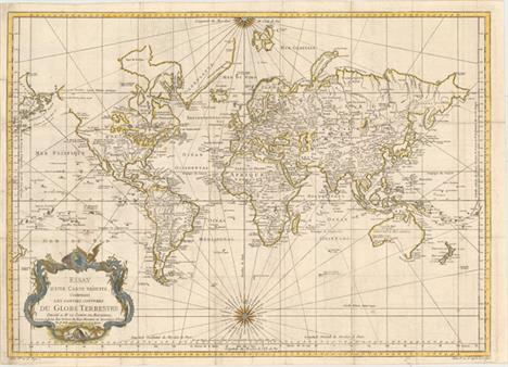
Essay d`une Carte Reduite, Contenant les Parties Connuees du Globe Terrestre... This very large and attractive world chart is drawn on Mercator`s projection. North America is shown with a prominent River of the West connecting through a series of rivers and lakes from Lake Superior to the Pacific - representing the elusive search for a Northwest Passage. The Russian discoveries in the North Pacific are shown with Alaska depicted as an island named I. Unamak. Australia is labeled Nouvelle Hollande with Terre de Diemen still linked to the mainland. New Zealand is fully formed showing both islands and there are numerous islands in the Pacific. The large, decorative title cartouche and two fine compass roses with rhumb lines make this a very attractive chart. Australia and New Zealand reflect the discoveries of Capt. Cook, but Tasmania is still attached to Australia, suggesting a publish date after 1770. Issued folding on watermarked paper with light offsetting, a few small spots, and some short fold separations and edge tears that have been archivally repaired. The sheet has been remargined with old paper at left. 20"" W x 27.9"" H Bellin, Jacques Nicolas 1748
![[6"" Lunar Globe] La Lune This attractive steel globe depicts the surface of the moon in good detail. Several unm](http://lot-images.atgmedia.com/SR/36385/2916721/45-2014116144350_468x382.jpg)
[6"" Lunar Globe] La Lune This attractive steel globe depicts the surface of the moon in good detail. Several unmanned, robotic landings from both the United States and former Soviet Union are depicted included landings from the Surveyor, Ranger and Luna programs. A 60-degree wide area on the far side of the moon is left blank, as these features were unknown at the time. The globe sits on a plastic base shaped to mimic the surface of the moon. A clean and bright example. 8"" W x 5.5"" H Replogle Globes, 1966


An early 19th century mahogany longcase clock, the caddy hood with brass globe finials and stop fluted columns above a long arched trunk door, enclosed between 1/4 column stop fluted pilasters, on a box base and bracket feet, the 33cm silvered dial with Roman numerals, a seconds subsidiary dial and a calendar dial, the eight day movement striking on a bell, 244cm high
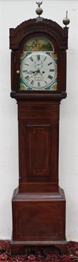
A 19th century mahogany longcase clock, the arched hood with brass globe finials and reeded columns and a short trunk door on a box base and bracket feet, the 33cm dial painted with a church on a river, with floral painted spandrels, the dial with Roman numerals, a seconds subsidiary dial and calendar aperture, inscribed R.E. Moseley, Swansea, 225cm high

A 19th century mahogany longcase clock, the arched hood with globe finials and rope twist columns short trunk door, box base and bracket feet, the 36cm dial with moonphase to the arch, Roman numerals, seconds subsidiary dial and calendar dial, the eight day movement striking on a bell, 217cm high


Der Weltumsegler wider Willen. Spielkarten. - Le navigateur malgré lui. Jack the circumnavigator of the globe. Kartenspiel mit 11 kolor. lithogr. Karten. O. O. u. J. [um 1850]. Deckeltitel auf Holz montiert und lose Tafeln. 16mo.Die Spielkarten zeigen in leicht humorvoller Weise die Reise des Weltumseglers Funkerl, beginnend beim Mutantrinken, im Reiseaufbruch, wie er am Mast gefesselt wird, seine Taufe, in Verkleidung als Dame, wie er als Frau verkleidet am japanischen Hof vorstellig wird, Herr Funkerl als Kaiser von Japan, Gitarre spielend, vor einer Sänfte, als Matrose und auf der Rückreise mit dem Dampfer. - Die kleinen Spielkarten jeweils unterh. der Darstellung mit 2 Zeilen Text und 1 Zeile Spielanweisung versehen. - Die Tafeln (knapp entlang der Einfassungslinie beschnitten) ca. 7,8 : 10 cm. - Deckel ca. 10 : 11,5 cm. - Karten angeschmutzt und mit kl. Knickspuren, Deckel (vermutl. von einer Spielschatulle) beschädigt.


A Geographia 8" terrestrial desk globe. Raised on a mythological figural bronzed spelter base formed as Atlas supporting the globe knelt over a reeded circular plinth. 47cm high. Condition Report. To be used as a guide only. Overall wear and some scratches to the metalwork. Phillips oval logo applied over the surface of the map unsure if this is original or not.


A Geographia 8" terrestrial desk globe. Raised on a mythological figural bronzed spelter base formed as Atlas supporting the globe knelt over a reeded circular plinth. 47cm high. Condition Report. To be used as a guide only. Overall wear and some scratches to the metalwork. Phillips oval logo applied over the surface of the map unsure if this is original or not.


An Ormolu and Porcelain Striking Mantel Clock, signed Hry Marc, A Paris, circa 1880, case depicting a winged cherub holding a scroll, globe and drawing instruments, scroll base with a floral porcelain panel, 3-1/2-inch enamel dial with Roman numerals signed, twin barrel movement with outside countwheel striking on a bell, raised upon an ebonised base and beneath a glass dome, 24cm by 35cm 07.10.14, Ormolu slightly faded in parts, dial and movement are clean, in going order and striking, glass dome is complete.

-
45705 item(s)/page