We found 45703 price guide item(s) matching your search
There are 45703 lots that match your search criteria. Subscribe now to get instant access to the full price guide service.
Click here to subscribe- List
- Grid
-
45703 item(s)/page


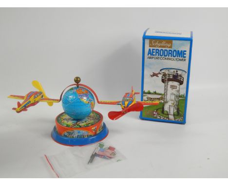

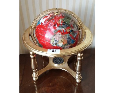
Lot 1543
A collection of clockwork, battery operated, tinplate and other toys including a Nomura 'Antique Car' in original box, Johan Models car, Lehmann cable car, Codeg Porsche Car-a-van in original box, ELM racing car, Religable Series globe, Quercetti Mach - X in original box, remote control bulldozer, remote control car etc

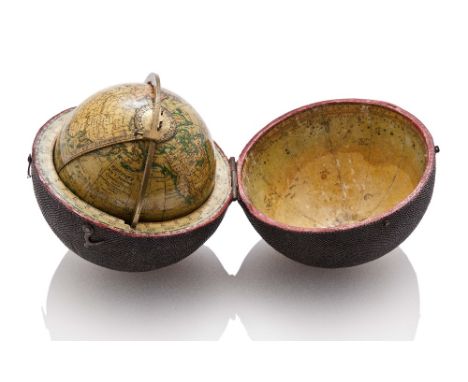
Lot 192
A FINE 3IN. POCKET GLOBE BY NEWTON SON & BERRY, LONDON, CIRCA 1835, with well-preserved hand-painted gores signed NEWTON'S New & Improved TERRESTRIAL GLOBE Published by Newton Son & Berry, 66 Chancery Lane, LONDON, mounted within calibrated brass meridian with indicator and contained in fishskin-covered wooden case with horizon ring and celestial gores in lid -- 4in. (10cm.) diameter
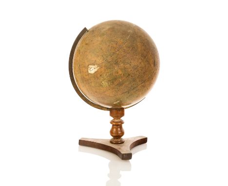
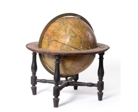
Lot 194
A 12IN. CELESTIAL GLOBE PUBLISHED BY G.F. CRUTCHLEY, LONDON CIRCA 1850, hand-painted gores signed as per title and inscribed Crutchley's Late Cary's New Celestial Globe ..., mounted through the Colurus Aequinoctium line with calibrated brass meridian on turned wood stand with tripod foot -- 18in. (45.5cm.) high; together with late 19th-century 12in. terrestrial globe by John Haywood, Manchester, London, mounted on turned stand with inset compass to base, (2),
![A FINELY DETAILED 1/8IN. TO 1FT SCALE MODEL OF THE STEAM YACHT NAHLIN, DESIGNED BY G.L WATSON AND BUILT BY JOHN BROWN [1930],](https://cdn.globalauctionplatform.com/1549e2bc-0f33-4c48-96b6-a5e10115989c/5bc7103a-2423-488c-e224-143be16fe08c/468x382.jpg)
Lot 315
A FINELY DETAILED 1/8IN. TO 1FT SCALE MODEL OF THE STEAM YACHT NAHLIN, DESIGNED BY G.L WATSON AND BUILT BY JOHN BROWN [1930], with bespoke moulded hull, planked deck with silvered fittings, painted and varnished superstructure, seven assorted and detailed boats swung out on davits and much other fine detailing, mounted on cradles within a glazed wooden display case -- 18½ x 47in. (47 x 119.5cm.), Undoubtedly the most famous pleasure yacht of her day, the Nahlin also achieved a degree of celebrity, some would say notoriety, after she was chartered for a summer cruise in 1936 by King Edward VIII, amongst whose guests was his companion, Mrs Wallis Simpson., Designed by G.L. Watson & Co. and built by John Brown at Glasgow in 1930, Nahlin had been ordered the previous year by Lady Henrietta Yule, the immensely wealthy widow of the business tycoon Sir David Yule who had died in 1928 leaving a fortune estimated at £20 million. Registered at 1,392 tons gross (556 net & 1,574 Thames), Nahlin measured 296 feet in length with a 36 foot beam and was powered by four of John Brown's own steam turbines to give her a cruising speed of 17½ knots. Described as "the most beautiful yacht in the world and the most seaworthy", Watson's brief had been to design a yacht to enable Lady Yule to "visit every part of the globe she desired" and the finished vessel fulfilled every expectation. Indeed, her appointments were so lavish that it was rumoured she cost £250,000 and her dimensions have rarely been surpassed, even by the most ultra-modern of luxury craft., After four years of extensive cruising, Lady Yule felt she had seen everything she wished to and, rather surprisingly, placed the yacht out to charter. In the late summer of 1936, the new -- though as yet uncrowned -- King Edward VIII decided to hire her for a cruise around the eastern Mediterranean with a party of special friends, including the American divorcee Mrs Wallis Simpson, who was already occupying a prominent place in the King's life. The resulting photographic coverage of the carefree couple on holiday was inevitably published in the British press and it has been said that the 'Abdication Crisis' of December 1936 probably started to gather momentum as a result of this public exposure of the King's liaison. The notoriety of this cruise brought Nahlin to the attention of King Carol II of Roumania who, in the summer of 1937, purchased her for £120,000. Renamed Lucearful ("Morning Star"), she was modified to suit the King's taste and acted as the Roumanian royal yacht until he was forced into exile in Spain when his country was occupied by German troops soon after the start of World War II., The subsequent history of Nahlin is tortuous in the extreme yet somehow she survived not only the War and its Communist aftermath but also obsolescence and decay. Once again bearing her original name, after numerous changes over the past fifty years, she completed a reputed £25 million restoration in 2010 which saw her steam turbines replaced with diesel, but otherwise retaining her fine lines, and she is now one of just three surviving large steam yachts from this elegant age. This lot will be available for viewing at Imperial Road
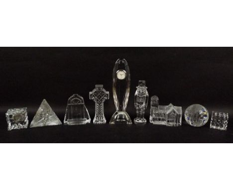
Lot 535A
A collection of Waterford glass figurines, 20th century, comprising John Rocha designed clock, 23cm, toy soldier, 1st edition, 15cm, Celtic cross, 14cm, Lismore Village church, 10cm, doorway, 10.5cm, globe, 7cm, faceted cube, 5cm, faceted cube clock, 6cm, and pyramid clock, Times Square 2000, 9cm. (9)
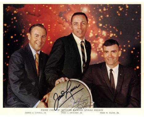
Lot 37
APOLLO XIII: A good signed colour 10 x 8 photograph by all three crew members of the ill-fated Apollo XIII mission individually, comprising James Lovell (1928- , Commander), Jack Swigert (1931-1982, Command Module Pilot) and Fred Haise (1933- , Lunar Module Pilot). The official NASA image depicts the three astronauts standing and seated together in a row, with a globe of the moon in the forefront. Signed by each in black inks with their names alone to a light area at the base of the image. Rare. About EX
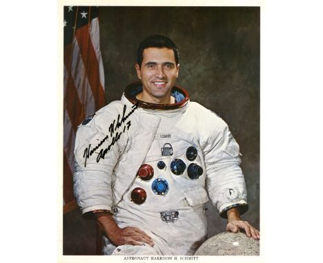
Lot 87
SCHMITT HARRISON: (1935- ) American Astronaut, Lunar Module Pilot of the Apollo XVII mission. The twelfth man to walk on the Moon. Signed colour 8 x 10 photograph of Schmitt standing in a three quarter length pose wearing his white spacesuit and with one hand resting on a globe of the Moon. Signed ('Harrison H Schmitt') in bold black ink to a clear area of the image, adding Apollo 17 in his hand beneath his signature. Together with a signed and inscribed 10 x 8 photograph by Schmitt, the official NASA image depicting Schmitt and the two other Apollo XVII crew members, Gene Cernan and Ron Evans, in an outdoors group pose together with the Moon Rover. All three wear their white spacesuits and in the background the Saturn Rocket of the Apollo XVII mission can be seen being rolled out in preparation for launch. The Apollo XVII mission emblem appears in the upper left corner. Signed by Schmitt in bold black ink to a clear area of the image, 'To George, Many thanks! Harrison H Schmitt, Apollo 17'. Some light traces of former mounting to the verso of the second photograph, VG to EX, 2
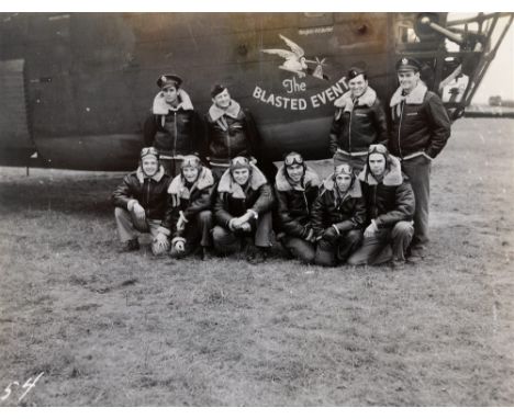
Lot 779
SECOND WORLD WAR AVIATION - CAPTAIN DONALD WHITED U.S. 8TH AIR FORCE - 93RD BOMBARDMENT GROUP HEAVY B-24 LIBERATORS BASED AT ALCONBURY, CAMBRIDGESHIRE - A VERY RARE PERSONAL PHOTOGRAPH COLLECTION, ONE HUNDRED BLACK & WHITE IMAGES IN TWO OFFICIAL US ARMY ALBUMS forty eight captioned to their reverse in ink, including twenty group photographs of named combat crews many wearing A-2 jackets with insignia, in front of their their Liberator aircraft, showing nose-art paintings 329th Combat Crew - 'The Blasted Event'; 329th Combat Crew - 'Hellsadroppin'; '330th Combat Crew - 'Big Dealer' (S.Daks killed over the desert 1943); 328th Combat Crew - 'Jerk's Natural' (Hudspeth, Prisoner of War, Germany); 328th Combat Crew -'Ball of Fire No.1'; 328th Combat Crew - 'Ball of Fire No.2' (Flubber Hawkins, Prisoner of War, Germany), (Joe Tate, Killed in Action over Germany); 409th Combat Crew 'Wham Bam' (Japanese Gunner); 329th Combat Crew - 'Globe Trotter' (I pulled gun turrets out of this ship, after it crashed up at Oxford Dec. 1942); 329th Combat Crew - (Dinks killed while doing night flying spring 1943); 329th Combat Crew (Jo Jo Jarvis killed over Ploesti, Romania - Ellison, killed over Ploesti) Operation Tidal Wave was an air attack by bombers of the USAAF based in Libya and Southern Italy on nine oil refineries around Ploesti, Romania on the 1st of August 1943. The mission was one of the costliest for the USAAF in the European Theatre with 53 aircraft and 660 aircrew lost. It was the worst loss ever suffered by the USAAF on a single mission, and its date was later referred to as 'Black Sunday' The first American Eighth Air Force unit to take residence at RAF Alconbury was the 93rd Bombardment Group known as the 'Travelling Circus' from Fort Meyers Florida on the 7th of September 1942. It was assigned to the 20th Combat Bombardment Wing at RAF Horsham, St. Faith near Norwich, the group flew Consolidated B-24 Liberator aircraft with a tail code of 'Circle B'. Its operational squadrons were: 328th Bombardment Squadron (GO); 329th Bombardment Squadron (RE); 330th Bombardment Squadron (AG); 409th Bombardment Squadron (YM). The 93d was the first Liberator-equipped bomber group to reach the Eighth Air Force. The group became operational with the B-24 on 9 October 1942 by attacking steel and engineering works at Lille in France. Until December, the group operated primarily against submarine pens along the French coast. On the 6th of December 1942, most of the group was transferred to Twelfth Air Force in North Africa to support the Operation Torch landings. The balance of the 93d BG was moved to RAF Hardwick (Station 104), near Bungay in Suffolk where B-24 groups were being concentrated.
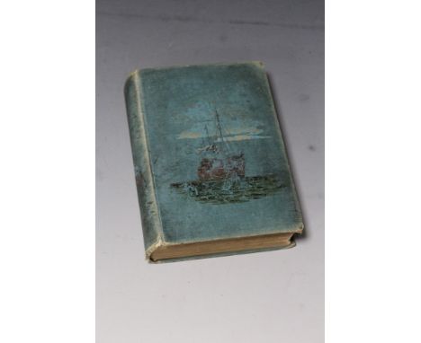
Lot 168
THOMAS R. DEWAR - 'A RAMBLE ROUND THE GLOBE', Chatto and Windus, 1894, 'Tommy' ist Baron Dewar was the son of James Dewar founder of the famous whisky companyCondition Report:Boards quite worn, spine detached, some foxing on initial pagesPlease note: every page of every book is not checked, if you are unable to view yourself please ask for detailed information
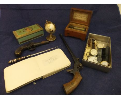
Lot 197
A Swiss two air musical box with lithograph decorated top, by Paillard Vaucher Fils, a 19th Century pocket pistol, a Belgian long barrelled pistol (action missing), an autograph album including Fred Astair, Jack Train, Olive Blakeney etc , a Corona globe table lighter, a collection of various watches, etc
-
45703 item(s)/page