We found 41221 price guide item(s) matching your search
There are 41221 lots that match your search criteria. Subscribe now to get instant access to the full price guide service.
Click here to subscribe- List
- Grid
-
41221 item(s)/page


Lot 72
Karl Lagerfeld. "My great luxury is not having to justify to justify myself to anyone. Snow globe adorned with gold representing Karl Karl Lagerfeld. Height: 8 cm. Note: trace of melting on the base - Weight: 310 g - Shipping available - Region: Allemagne - Sizes: h 100 mm d 80 mm - At first glance: good condition


Lot 57
Two cut-glass decanters - comprising a late 20th century square decanter with diamond, printie and prismatic cutting, star-cut base and diamond and star-cut globe stopper, 26.5cm. high; and Bohemian shaft and globe decanter with blaze, cross, sunburst and panel-cut body below a panel cut neck, star-cut base, with panel-cut stopper, 38cm. high.


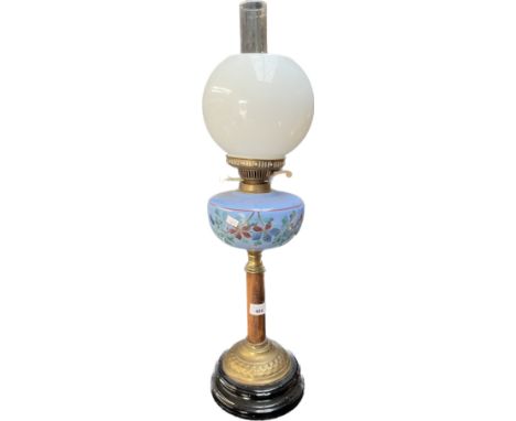
![Antique glass and brass base paraffin lamp, Glass funnel and globe present. [69cm high]](https://cdn.globalauctionplatform.com/70fcd7fb-a797-4b74-aba4-b0b600a8fc48/ee59777e-16ff-4e4e-8d2f-b0b800bcbcb4/468x382.jpg)
![1920s Globe-Wernicke oak 2 section barristers bookcase [84x87x30.5]](https://cdn.globalauctionplatform.com/70fcd7fb-a797-4b74-aba4-b0b600a8fc48/7cbae4f9-e9aa-481a-8d0b-b0b800c02b94/468x382.jpg)
Lot 151
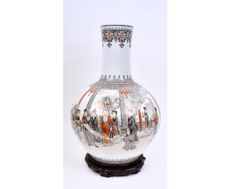
A large 20th century Chinese Oriental Qianlong four-character mark hand painted ceramic vase on stand. The vase having a tall neck over a globe shaped body. Hand painted decorations throughout in red & black colourways. Depicting a sale of a scroll to a wealthy gentleman, all characters in Ming style garments. Raised on traditional wooden plinth base. Measures approx. 60cm tall x 35cm in diameter.

Lot 55
Globe Wernicke - a vintage early 20th century oak five-tier sectioned barristers bookcase / library stacking cabinet. The bookcase having five glazed sliding in door sections. All raised on shaped plinth base with twin handled drawer. Inner label to bottom section. Measures approx. 184cm x 87cm x 27cm.
Lot 201
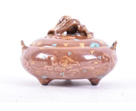
A late 19th century Chinese Oriental ceramic lidded censer. The censer having a lid with dragon holding the universe globe as handle. Squatted round body with twin handles to sides. Brown glaze finish with gold & turquoise detailing. Four character Qianlong mark to base. Measures approx. 6cm x 9cm x 9cm.


![Four West Country Friendly Society brass staff heads, comprising Puddletown [Dorset] 19cm high cast with a blade head over sh](https://cdn.globalauctionplatform.com/9609e91c-1ea8-4379-8b16-b0ab009b886e/c1af49be-f14e-403d-826c-b0b5012c952e/468x382.jpg)
Lot 365
Four West Country Friendly Society brass staff heads, comprising Puddletown [Dorset] 19cm high cast with a blade head over shaft and globe, 19cm high; another of sword form for Long Burton [Dorset] 11cm high; Sherborne Old Friendly Society, pierced with initials and '1761' 18cm high; and an unidentified example of globe and shaft form, 15cm high (4)


Lot 222
An Art Deco cast metal figural table lamp. Modelled as a standing female dancer holding a large glass globe on a stepped plinth base, height 56cm, together with two other Art Deco figural table lamps. (3)The glass globes are not original to the lamps but two are period, general wear and dirt no major condition issues.

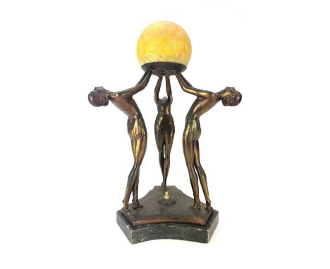
Lot 279
An Art Deco gilt spelter figural table lamp. Modelled with a trio of female dancers lifting a glass globe on a triform marble base, height 46cm.The group is detached from the base, which has a few scratches and marks. The finish is spotted and pitted generally, with some wear.The electrics will need to be rewired, the shade is not the original.


Lot 433
Antique wooden tabletop globe or sphere with a wooden travelling case. The sphere with a stand with three legs - missing one leg.(Globe) diameter: 9 in. (Stand) height: 6 1/2 in x width: 7 1/4 in x depth: 7 1/4 in. (Case) height: 8 1/2 in x width: 8 1/4 in x depth: 8 in. />Condition: Please contact us for a detailed condition report. Please note that the lack of a condition statement does not imply perfect condition. Email condition@revereauctions.com with any condition questions.

Lot 128
Deux statuettes en porcelaine de Meissen représentant Atlas portant le monde, circa 1750Two Meissen figures of Atlas holding a globe, circa 1750Holding a celestial and an earthly globe, respectively, the bearded figure with a seated on rocks on a base moulded with gilt-edged scrollwork, 16cm high, crossed swords marks in underglaze-blue (figure with earthly globe with chips to fingers on right hand and to tip of finger on left hand) (2)For further information on this lot please visit Bonhams.com

Lot 121
Thomson (John). A New General Atlas, consisting of a series of geographical designs on various projections, exhibiting the form and component parts of the Globe; and a collection of maps and charts, delineating the natural and political divisions of the empires, kingdoms, and states in the World. Constructed from the best systematic works, and the most authentic voyages and travels. With a memoir of the progress of geography, a summary of physical geography, and a consulting index to facilitate the finding out of places, Edinburgh: Printed by George Ramsay and Company, for John Thomson and Company, Edinburgh; Baldwin, Cradock, and Joy, London; and John Cumming, Dublin, 1817, printed title with some spotting, dedication to Alexander Keith of Dunottar and Ravelston, a 'Memoir of the Progress of Geography', uncoloured engraved double-page comparison plate with two small holes and some marginal closed tears, list of maps and charts, 23 pages of introductory text and 22 pages of a consulting index, several preliminary leaves frayed. torn and detached, 65 (only of 74) double-page and folding maps, all with contemporary outline colouring, some off-setting and slight spotting, some staining throughout, a few maps frayed at the margins, map of the Western hemisphere torn in half, maps of Europe and the British Isles with long closed tear, map of England split in half with frayed margins, Africa with small area of juvenile scribbling, Southern Provinces of the United States split and frayed along old fold, map of Caraccas and Guiana heavily stained and spotted, frayed with slight loss and laid on later stiff paper, hinges broken, contemporary half calf, lacking spine, boards near detached, heavily worn and frayed, folioQTY: (1)NOTE:Lacking the maps of:- The World on Mercator's projection, The North Horizontal Hemisphere, Ireland, Remote British Islands, sheets 3 & 4 the four sheet map of Europe, General Map of Asia, Hindostan, Atlantic Islands and South America. Sold as a collection of maps, not subject to return.
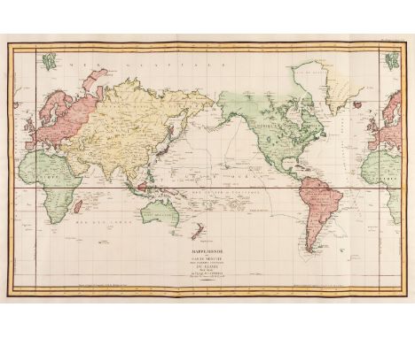
Lot 128
World. Perouse (Jean Francois Galaup, Comte de la), Mappe Monde ou Carte Reduite des Parties Connues du Globe pour Servir au Voyage de la Perouse, Paris [1797], large hand-coloured engraved map on a hemispheral projection, centred on the Pacific, old folds, 590 x 910 mm, together with Collins (Rear Admiral K. St B. OBE, DSC, Hydrographer). The World, published by the Admiralty, 1966, colour printed map of the world, slight staining to the margins, 680 x 1000 mmQTY: (2)NOTE:The first described item shows the Voyage of Captain La Perouse, a French naval officer and explorer and illustrates his voyages between 1785 - 88. La Perouse and his expeditionary force vanished in Oceania in 1788, his final fate unknown.

Lot 152
* Gillray (James). Fighting for the Dunghill - or - Jack Tar settling Buonaparte, H. Humphrey, Novr. 20th 1798, etching with aquatint on wove, contemporary hand-colouring, one small area of paper weakness, strengthened with later paper on verso, 260 x 360 mmQTY: (1)NOTE:BM Satires number 9268.From the Royal Museum Greenwich catalogue entry for the Edinburgh edition (PAD4792):This is the earliest of Gillray’s portrayals of Bonaparte as the symbolic personification of France. Here he is caricatured in a manner deriving from earlier 18th-century lampoons against the French, particularly by Hogarth, in being shown semi-naked and emaciated. Gillray also plays upon Bonaparte’s Corsican roots, notably in the Italian spelling of his name in the title. Seated atop a globe, he is being knocked down and has his nose bloodied by a stout British tar with the profile features of George III. It is a simple but effective piece of propaganda, casting France with the dark, benighted side of the globe, and Britain with the bringing of light. At the same time, the fusion of the King with Jack Tar is a brilliant means of suggesting a national unity between the upper and lower orders that was, at this time, far from being the case.
Lot 34
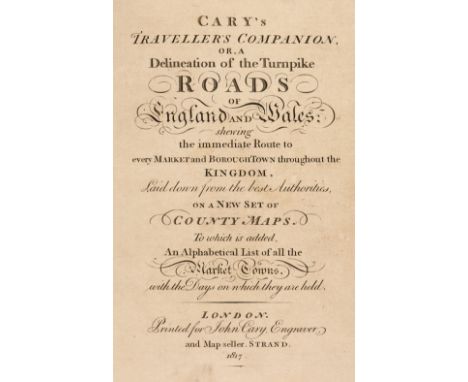
Cary (John). Cary's Traveller's Companion or a Delineation of the Turnpike Roads of England and Wales; shewing the immediate Route to every Market and Borough Town throughout the Kingdom..., 1817, calligraphic title, advertisement and contents leaf, 43 (complete) engraved maps with contemporary outline colouring (complete), including folding map of Yorkshire (Yorkshire with long closed tear), index of market towns bound at rear, bound with Cary's New Itinerary: or an Accurate Delineation of the Great Roads, Both Direct and Cross throughout England and Wales: with many of the Principal Roads in Scotland..., J. Cary, 1817, calligraphic title and dedication, folding engraved map of England and Wales with long closed tear, six engraved folding regional maps with contemporary outline colouring, further tables and indices, endpapers with later pencil annotations and notes, contemporary 'envelope style' black morocco binding, 8vo, together with Cary's New Map of England and Wales with part of Scotland. with Part of Scotland, on which are carefully laid down all the Direct and Principal Cross Roads, the Course of the Rivers and the Navigable Canals, Cities, Market and Borough Towns, Parishes and most considerable Hamlets, Parks, Forests &c &c, 1st edition, June 11th 1794, title and dedication, general map of England & Wales and table of explanation, and 76 (complete) engraved map sheets (numbered 1 - 81 and omitting 62/63, 71/72 & 80 as intended), all with contemporary outline colouring, index bound at rear, some offsetting, text block cracked and partially split, contemporary sheep in an 'envelope style' heavily worn and frayed, 4to, with Fordham (Sir Herbert George). John Cary. Engraver, Map, Chart, Print-Seller and Globe Maker 1754 to 1835, Wm. Dawson & Sons Ltd, 1976, additional half-title, publisher's gilt cloth, 8vo, plus Barber (Peter, editor). The Map Book, Weidenfeld & Nicholson, 2005, additional decorative half-title, numerous colour plates throughout, publisher's gilt cloth, dust jacket torn with slight loss to the spine, folioQTY: (4)
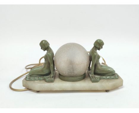
Lot 166
Art Deco verdigris bronze table lamp modelled as opposing seated nude females with glass shade to the centre, raised on alabaster style plinth base.16cm high, 32cm wide.Condition report:Fitted for electricity, electrical rewiring required.Two large cracks to foot of glass globe. On figure is quite loose.

Lot 158
A William Moorcroft pottery Leaf and Berry Pattern globe vase c.1935tube line decorated with leaves and pendant berries on a streaky dark blue ground, script WM and impressed W Moorcroft Potter To H.M. The Queen and facsimile signature in blue height 21cm.Condition: Good condition. Free from chips damage or restoration. Slight very feint crazing

Lot 246
Lead crystal with gold accents. Includes Globe, Tropical Island, Treasure Chest, and Anchor. Part of the Crystal Memories Collection. Swarovski backstamp on most pieces. Comes in original boxes with dimensions: 3.5"L x 1.5"W x 2.25"H. Largest piece measures 1"L x 0.75"W x 1.5"H. Issued: 20th centuryManufacturer: SwarovskiCountry of Origin: AustriaCondition: Age related wear.


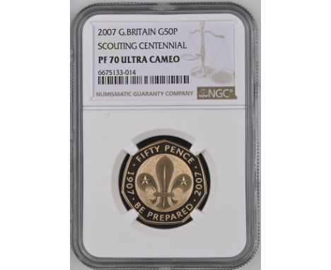
Lot 133
UNITED KINGDOM. Elizabeth II, 1952-2022. Gold 50 pence, 2007. Royal Mint. Proof. Commemorating the Centenary of the Foundation of the Scouting Movement. Robert Baden-Powell's book Scouting for Boys was published in January 2008 but his first Scouting camp on Brownsea Island, England in mid-1907 is regarded as the starting point for the movement.Fourth crowned head of HM Elizabeth II facing right; IRB below; ELIZABETH · II · D · G REG · F · D · 2007. Design by Ian Rank-Broadley. / Fleur-de-lis with two stars superimposed over a globe, 'FIFTY PENCE' above, 'BE PREPARED' below, anniversary dates 1907 and 2007 on either side. Design by Kerry Jones. Edge plain.In secure plastic holder, graded NGC PF 70 ULTRA CAMEO, certification number 6675133-014. NGC Census in this grade: 14, equal-finest graded.Total NGC Census: 24Reference: S-H17 (was 4619)Mintage: 1,250.Diameter: 27.3 mm.Thickness: 1.78 mm.Weight: 15.5 g. (AGW=0.4570 oz.)Composition: 917.0/1000 Gold.PLEASE NOTE: 6% Buyer Premium + VAT on this lot. Additional 6% fee charged on the Saleroom. Delivery cost will be added to your order.This lot is exempt from VAT. Payment can be made in EUR, CHF, or USD for an exchange fee. Please contact us to find out more.
-
41221 item(s)/page