

Colonial New England and Canada (Partie Orientale de la Nouvelle France ou du Canada), Bellin, Paris, 1755. 21.3 x 17”. (HC) This is the final state of Bellin`s definitive map of eastern Canada and New England showing the mouth of the St. Lawrence, the length of the river, the Maritime provinces and French claims in the region. There are some very interesting details of the coastal towns, showing Havre de Baston for Boston Harbor, up the coast to Portsmouth in New Hampshire, Wells, York and Cape Elizabeth in Maine. There is considerable information shown on the extent of French exploration in the region. In this state, Bellin updated the plate with changes to the Saint Lawrence River, Lake Ontario and Cape Code. A large decorative cartouche incorporates two distance scales. Ref: Kershaw no.689; McCorkle no.745.1, Sellers and Van Ee no.273. Watermarked paper with a couple of minor spots, few miniscule worm holes at top right, and a light damp stain with a couple of tiny tears along centerfold at bottom. Remnants of paper tape on verso. (+B)
We found 63909 price guide item(s) matching your search
There are 63909 lots that match your search criteria. Subscribe now to get instant access to the full price guide service.
Click here to subscribe- List
- Grid
-
63909 item(s)/page

Colonial United States and Canada (Partie du Nord de l`Amerique Septentrionale pour Servir a l`Histoire Philosophique et Politique…), Bonne, Raynal`s Histoire Philosphique et Politique, Geneva, ca. 1774. 9.3 x 12.6”. (HC) This attractive map of the eastern part of North America shows the British colonies confined along the eastern seaboard with French Louisianne and Canada taking up the interior. In the upper left is a series of rivers and lakes purportedly connecting Hudson Bay with "la Mer de l`Ouest" (Sea of the West). Features include the notation of the Natchitoches tribe in Louisiana Territory, along with numerous additional native tribes. Three distance scales and a fine shield-style cartouche embellish the composition. No engraver`s imprint on this edition. Ref: McCorkle no.774.1. Watermarked paper with some minor extraneous creasing and a few small spots. (+B)

Southeast United States (Carte de la Partie Sud des Etats Unis de l`Amerique Septentrionale), Bonne, Paris, ca. 1778. 12.5 x 8.3”. (HC) Attractive and concise copper-engraved map that covers the states of Virginia, North and South Carolina, and Georgia in the new United States. All settlement is confined east of the Appalachians with les Cherokees the only note in the otherwise blank region west of the mountains. There are four distance scales located on the left side of the map. Engraved by Andre. Ref: Sellers & Van Ee no.1406. Faint offsetting. (A)
![Florida, Georgia ([Lot of 2] Florida. Nach den besten Quellen bearbeitet [and] Neueste Karte von Georgia mit seinen Strassen,](http://lot-images.atgmedia.com/SR/36385/2862480/176-2012510161833_468x382.jpg)
Florida, Georgia ([Lot of 2] Florida. Nach den besten Quellen bearbeitet [and] Neueste Karte von Georgia mit seinen Strassen, Eisenbahnen und Entsernungen), Meyer, Hand Atlas, 1845. 11.5 x 14.5”. (HC) A. Florida. Nach den besten Quellen bearbeitet. This is an interesting map of the state of Florida based on the important Mitchell series showing towns, forts, roads, canals, major rivers and lakes. There are references to forts, battlefields, and routes used by the Army during the Seminole War. There are also three inset maps detailing Pensacola, Tallahassee, and St. Augustine. Water routes from St. Augustine and Pensacola to various ports are described along the upper and lower margins. B. Neueste Karte von Georgia mit seimen Strassen, Eisenbahnen und Entsernungen. This is the German edition of the Tanner/Mitchell Georgia map from the New Universal Atlas, with a German title but using English place names. Along the bottom of the map are the steamboat routes from Savannah to Augusta and Charleston (here spelled Carleston). The map shows early county development along with gold mines, canals, trails, roads and railroads. It has a remarkable twelve distance scales. Florida has a few faint spots with light toning along sheet edges Georgia is lightly toned with a few edge tears confined to the blank margins that are closed on verso with archival tape. (+B)

Central South America, Paraguay (Paraguay, o Prov. de Rio de la Plata cum Regionibus Adiacentibus Tucuman et Sta. Cruz de la Sierra), Blaeu, Amsterdam, ca. 1640. 19 x 14.8”. (HC) Superb map of the region including the Paraguay River basin and the Peru-Chilean coast with Lake Titicaca. The Rio de la Plata is boldly shown with many large islands in the broad river. The mythical Lago de los Xarayes is featured on the map, which was believed to connect the Rio de la Plata and Amazon River systems. Several towns are named including R. Ianeiro, S. Paulo, Buenos Ayres, Corduba, Medoca, Arica, Potosi and Cusco. A large decorative title cartouche incorporates the distance scales, while a smaller cartouche features an armillary sphere. A fine, large compass rose with fleur-de-lys also adorns the sheet. Dutch text on verso. Old color and wide margins with light damp stains that just enter map border at bottom & a couple tiny tears in wide original margins, none affecting the map. (+B)

Bedford, England (Bedford Shire), Morden, Britannia, London, ca. 1722. 15.8 x 12.5”. (BW) This county map of Bedfordshire shows the early road system with the city of Bedford located at center along the Great Ouse river. The map is divided into Hundreds and displays interesting detail including the locations of buildings, rivers, bridges and parks. There is an attractive drape-style cartouche and three distance scales. Sold by Abel Swale, Awnsham & John Churchil. Morden was one of the first English cartographers to show longitudes measured from the meridian of St. Paul`s Cathedral (shown in degrees at the bottom of the map) and time in minutes measure locally from the sun (shown at the top in Roman numerals). The roads on his maps are based on Ogilby`s earlier survey. The Britannia was first published by historian William Camden (1551-1623) in 1586. After the publication of the final edition of Britannia in 1637, the work was not published again until 1695 when Gibson revised and translated the text from the original Latin and included fifty maps, mostly of the English counties, prepared by Robert Morden, replacing the outdated maps of Christopher Saxton. This map is from the subsequent edition of 1722. Watermarked paper with some light printer`s ink residue, else very good. (+B)

Huntington, England (Huntington Shire), Morden, Britannia, London, ca. 1722. 17 x 14”. (BW) This county map of Huntingtonshire shows the early road system. The map is divided into Hundreds and displays interesting detail including the locations of buildings, rivers, bridges and parks. The city of Cambridge in Cambridgeshire is located at right. There is an attractive drape-style cartouche and three distance scales. Sold by Abel Swale, Awnsham & John Churchil. Morden was one of the first English cartographers to show longitudes measured from the meridian of St. Paul`s Cathedral (shown in degrees at the bottom of the map) and time in minutes measure locally from the sun (shown at the top in Roman numerals). The roads on his maps are based on Ogilby`s earlier survey. The Britannia was first published by historian William Camden (1551-1623) in 1586. After the publication of the final edition of Britannia in 1637, the work was not published again until 1695 when Gibson revised and translated the text from the original Latin and included fifty maps, mostly of the English counties, prepared by Robert Morden, replacing the outdated maps of Christopher Saxton. This map is from the subsequent edition of 1722. There is a hint of offsetting in the image and faint toning along centerfold. Watermarked paper. (+B)
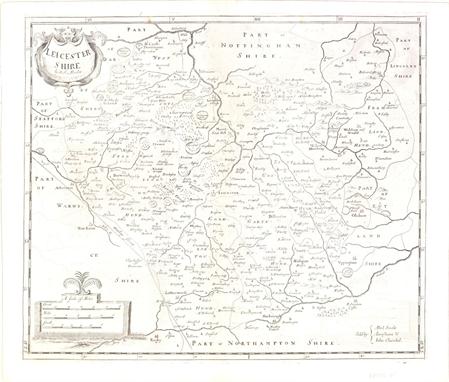
Leicester, England (Leicester Shire), Morden, Britannia, London, ca. 1722. 17 x 14”. (BW) This county map of Leicester shows the early road system. The town of Leicester is located near the center of the map along the Soar River. The map is divided into Hundreds and displays interesting detail including the locations of buildings, rivers, bridges and parks. There is a decorative title cartouche and three distance scales. Sold by Abel Swale, Awnsham & John Churchil. Morden was one of the first English cartographers to show longitudes measured from the meridian of St. Paul`s Cathedral (shown in degrees at the bottom of the map) and time in minutes measure locally from the sun (shown at the top in Roman numerals). The roads on his maps are based on Ogilby`s earlier survey. The Britannia was first published by historian William Camden (1551-1623) in 1586. After the publication of the final edition of Britannia in 1637, the work was not published again until 1695 when Gibson revised and translated the text from the original Latin and included fifty maps, mostly of the English counties, prepared by Robert Morden, replacing the outdated maps of Christopher Saxton. This map is from the subsequent edition of 1722. There is some light offsetting, else very good. Watermarked paper. (+B)

Northampton, England (Northampton Shire), Morden, Britannia, London, ca. 1722. 16 x 14”. (BW) This county map of Northamptonshire shows the early road system, with Northampton located at the center of the sheet. The map is divided into Hundreds and displays interesting detail including the locations of buildings, rivers, bridges and parks. There is an attractive drape-style cartouche and three distance scales. North is oriented to the right. Sold by Abel Swale, Awnsham & John Churchil. Morden was one of the first English cartographers to show longitudes measured from the meridian of St. Paul`s Cathedral (shown in degrees at the bottom of the map) and time in minutes measure locally from the sun (shown at the top in Roman numerals). The roads on his maps are based on Ogilby`s earlier survey. The Britannia was first published by historian William Camden (1551-1623) in 1586. After the publication of the final edition of Britannia in 1637, the work was not published again until 1695 when Gibson revised and translated the text from the original Latin and included fifty maps, mostly of the English counties, prepared by Robert Morden, replacing the outdated maps of Christopher Saxton. This map is from the subsequent edition of 1722. There is a hint of toning along the centerfold, with a portion of the centerfold reinforced with old paper. Watermarked paper. (+B)

Cheshire, England (The County Palatine of Chester), Morden, Britannia, London, ca. 1722. 16 x 14”. (BW) This county map of Cheshire shows the early road system with the town of Chester located on the left side of the sheet next to the River Dee. The map is divided into Hundreds and displays interesting detail including the locations of buildings, rivers, bridges and parks. There is a decorative title cartouche and three distance scales. Sold by Abel Swale, Awnsham & John Churchil. Morden was one of the first English cartographers to show longitudes measured from the meridian of St. Paul`s Cathedral (shown in degrees at the bottom of the map) and time in minutes measure locally from the sun (shown at the top in Roman numerals). The roads on his maps are based on Ogilby`s earlier survey. The Britannia was first published by historian William Camden (1551-1623) in 1586. After the publication of the final edition of Britannia in 1637, the work was not published again until 1695 when Gibson revised and translated the text from the original Latin and included fifty maps, mostly of the English counties, prepared by Robert Morden, replacing the outdated maps of Christopher Saxton. This map is from the subsequent edition of 1722. There is light toning along the centerfold, faint offsetting and a few tiny spots in the image. There is one minute pinhole at left and a printer`s crease along the lower neatline. Watermarked paper. (+B)

Wilts, England (Wilt Shire), Morden, Britannia, London, ca. 1722. 16.3 x 13.5”. (BW) This county map of Wiltshire shows the early road system. The map is divided into Hundreds and displays interesting detail including the locations of buildings, rivers, bridges parks and mountains in profile. There is an attractive drape-style cartouche and three distance scales. Sold by Abel Swale, Awnsham & John Churchil. Morden was one of the first English cartographers to show longitudes measured from the meridian of St. Paul`s Cathedral (shown in degrees at the bottom of the map) and time in minutes measure locally from the sun (shown at the top in Roman numerals). The roads on his maps are based on Ogilby`s earlier survey. The Britannia was first published by historian William Camden (1551-1623) in 1586. After the publication of the final edition of Britannia in 1637, the work was not published again until 1695 when Gibson revised and translated the text from the original Latin and included fifty maps, mostly of the English counties, prepared by Robert Morden, replacing the outdated maps of Christopher Saxton. This map is from the subsequent edition of 1722. Watermarked paper with some offsetting, light printer`s ink residue, and a 0.5" hole near the centerfold repaired with old paper on verso, with minor loss of image. (B)

Stafford, England (Stafford Shire), Morden, Britannia, London, ca. 1722. 14.5 x 17”. (BW) This county map of Staffordshire shows the early road system, with the town of Stafford located at the center of the sheet. The map displays interesting detail including the locations of buildings, rivers, bridges and parks. There is a decorative title cartouche and three distance scales. Engraved by Sutton Nicholls and sold by Abel Swale, Awnsham & John Churchil. Morden was one of the first English cartographers to show longitudes measured from the meridian of St. Paul`s Cathedral (shown in degrees at the bottom of the map) and time in minutes measure locally from the sun (shown at the top in Roman numerals). The roads on his maps are based on Ogilby`s earlier survey. The Britannia was first published by historian William Camden (1551-1623) in 1586. After the publication of the final edition of Britannia in 1637, the work was not published again until 1695 when Gibson revised and translated the text from the original Latin and included fifty maps, mostly of the English counties, prepared by Robert Morden, replacing the outdated maps of Christopher Saxton. This map is from the subsequent edition of 1722. There is some faint offsetting, a hint of toning along the fold, and a printer`s crease above the centerfold. Watermarked paper. (+B)

Lincoln, England (Lincoln Shire), Morden, Britannia, London, ca. 1722. 16.5 x 14.3”. (BW) This county map of Lincolnshire shows the early road system, with the town of Lincoln located near the center of the sheet. The map displays interesting detail including the locations of buildings, rivers, bridges and parks. There is a decorative title cartouche and three distance scales. Sold by Abel Swale, Awnsham & John Churchil. Morden was one of the first English cartographers to show longitudes measured from the meridian of St. Paul`s Cathedral (shown in degrees at the bottom of the map) and time in minutes measure locally from the sun (shown at the top in Roman numerals). The roads on his maps are based on Ogilby`s earlier survey. The Britannia was first published by historian William Camden (1551-1623) in 1586. After the publication of the final edition of Britannia in 1637, the work was not published again until 1695 when Gibson revised and translated the text from the original Latin and included fifty maps, mostly of the English counties, prepared by Robert Morden, replacing the outdated maps of Christopher Saxton. This map is from the subsequent edition of 1722. There are a few minor spots in the image and a small printer`s crease in the upper portion of the image near the neatline. Watermarked paper. (+B)

Berkshire, England (Bark Shire), Morden, Britannia, London, ca. 1722. 16.5 x 14”. (BW) This county map of Berkshire shows the early road system and Windsor Castle at lower right. The map is divided into Hundreds and displays interesting detail including the locations of buildings, rivers, bridges and parks. There is an attractive drape-style cartouche and three distance scales. Sold by Abel Swale, Awnsham & John Churchil. Morden was one of the first English cartographers to show longitudes measured from the meridian of St. Paul`s Cathedral (shown in degrees at the bottom of the map) and time in minutes measure locally from the sun (shown at the top in Roman numerals). The roads on his maps are based on Ogilby`s earlier survey. The Britannia was first published by historian William Camden (1551-1623) in 1586. After the publication of the final edition of Britannia in 1637, the work was not published again until 1695 when Gibson revised and translated the text from the original Latin and included fifty maps, mostly of the English counties, prepared by Robert Morden, replacing the outdated maps of Christopher Saxton. This map is from the subsequent edition of 1722. There is some light offsetting and printer`s ink residue in the image, else very good. A tiny tear in bottom blank margin has been closed on verso with old paper. Watermarked paper. (+B)

Nottingham, England (Nottingham Shire), Morden, Britannia, London, ca. 1722. 16 x 14”. (BW) This county map of Nottinghamshire shows the early road system, with the town of Nottingham located in the lower portion of the sheet. The map displays interesting detail including the locations of buildings, rivers, bridges and parks. There is a decorative title cartouche and three distance scales. Sold by Abel Swale, Awnsham & John Churchil. Morden was one of the first English cartographers to show longitudes measured from the meridian of St. Paul`s Cathedral (shown in degrees at the bottom of the map) and time in minutes measure locally from the sun (shown at the top in Roman numerals). The roads on his maps are based on Ogilby`s earlier survey. The Britannia was first published by historian William Camden (1551-1623) in 1586. After the publication of the final edition of Britannia in 1637, the work was not published again until 1695 when Gibson revised and translated the text from the original Latin and included fifty maps, mostly of the English counties, prepared by Robert Morden, replacing the outdated maps of Christopher Saxton. This map is from the subsequent edition of 1722. Watermarked paper with some light offsetting and a few small spots in the image, else very good. (+B)

England & Wales (England), Morden, Camden`s Britannia, London, ca. 1695. 16.5 x 14.3”. (HC) Robert Morden was commissioned by Dr. Edmund Gibson to prepare new maps for Camden`s Britannia, which was last published early in the century with maps by Hole and Kip. However, no additional survey work was done by Morden, so this map draws largely upon the work of Saxton and Speed. The map itself is relatively straightforward and depicts counties, cities and roads. The title is enclosed in an elegant cartouche along with three distance scales. Ref: Shirley (BI to 1750) Morden 10. There is a 0.25" loss near Gloucester that has been covered with old paper on verso and light toning in blank margins. (+B)
![France ([Lot of 2] Typus Galliae Veteris [and] Aurelianensis Praefectura Generalis…), Amsterdam, ca. 1635-1700. x ̶](http://lot-images.atgmedia.com/SR/36385/2862480/522-201251016455_468x382.jpg)
France ([Lot of 2] Typus Galliae Veteris [and] Aurelianensis Praefectura Generalis…), Amsterdam, ca. 1635-1700. x ”. (HC) A. Typus Galliae Veteris, by Willem Blaeu, circa 1635 (20 x 15.5"). Handsome map of ancient France, based on the cartography of Abraham Ortelius, who is credited in the cartouche. Fully engraved with mountains, forests and ancient place names and decorated with a strapwork title cartouche. German text on verso. Condition: Wide margins, with a stain in border at left that does not distract. (A) B. Aurelianensis Praefectura Generalis…, Gerard and Leonard Valck, circa 1700 (23.5 x 19.2"). Very strongly engraved map centered on Orleans and Tours. The map extends to the Atlantic at the Bay of Biscay and east to Burgundy. Fortified towns are identified and hundreds of small villages are named. Locates Thiers, Uzerche, Niort, Nantes, Rennes, Seez, Auxerre, and many more. Two distance scales at upper right and legend opposite. Condition: Very dark impression and original outline color. On thick, sound paper that was previously framed leaving behind mounting paper on verso at edges and overall toning from framing. The centerfold backstrap protected this region from toning resulting in a lighter area. (B) See description. ()

Germany (Saxoniae, Misniae, Thuringiae, Nova Exactissimaq Descriptio), Ortelius, Theatrum Orbis Terrarum, Antwerp, ca. 1573. 19.8 x 13.5”. (HC) This handsome map covers Saxony and the surrounding region with great detail. It is embellished with a decorative title cartouche, a legend in scroll-style cartouche, distance scales and a decorative border. The map is filled with place names, each symbolized by a tiny castle. Dutch text on verso. Ref: Van den Broecke no.93. Attractive old color on watermarked paper with light damp stains in blank margins. French manuscript writing on verso opposing the Dutch text. (A)

Czech Republic (Bohemiae Nova Descriptio Tabula XVII), Munster, Geographia, Basel, ca. 1552. 14.8 x 11.8”. (BW) This is a Ptolemaic-style woodcut map of Bohemia oriented with north to the bottom. Prague is shown near the center of the map. The exaggerated mountains and forests are typical of the early woodblock maps. This is an early map to show the encroachment of the Ottoman Empire into Europe. A table describing map symbols, including Christian and Moslem villages, is at the lower right. Latin text on verso marked page 46. The right and left hand coordinate scales are partially trimmed with a small repair at the upper centerfold. Minor creasing along the centerfold. (B)

Austria (Austriae Archiducatus Inferioris et Superioris…), Danckerts, Amsterdam, ca. 1680. 22.8 x 19.5”. (HC) This boldly engraved map details Lower Austria, along the course of the Danube River, and features numerous place names, towns, cities, villages, churches and topography. Wienn (Vienna), Baden and many other fortified cities are located in this very striking example. The map extends west to Enns and Rottenmann. At bottom right is a small inset of Upper Austria, roughly centered on Lintz (Linz). The inset is surrounded by a river god and two putti holding the coat of arms for Lower Austria. The title is flanked by a legend and two distance scales. Old color with light toning along centerfold, a printer`s crease at lower right, and some spots. There is a centerfold separation that enters 1.5" into image that has been closed on verso with old paper, and some minor damp stains in blank margins that just enter map border. (B)

Crete (Candia met de Omleggende Eylanden), Doncker, Nieuw Groot Stuurmans Straets-Boeck, Amsterdam, ca. 1664. 20.2 x 15.5”. (HC) This very rare sea chart features Crete and surrounding islands. It is decorated with a strapwork and garland style title cartouche, three different scales of miles, two compass roses with north oriented to the right, and is filled with rhumb lines. There is a tiny hole to the right of Crete, a few faint spots, and some very light marginal soiling. (+B)

Corsica, Sardinia (Isles de Corse et de Sardaigne), Bonne, Paris, ca. 1780. 9 x 13.5”. (HC) This is an attractive, small map of Corsica and Sardinia, with a small portion of the mainland at upper right. There is good detail of topography, rivers and villages and five different distance scales. Good impression on thick, watermarked paper. There is a hint of offsetting and two short tears at right that have been archivally repaired. (+B)

Southeast Asia (Archipel des Indes Orientales, qui Comprend les Isles de la Sonde, Moluques et Philippines), Robert de Vaugondy, Atlas Universel, Paris, 1750. 23.5 x 19”. (HC) A detailed depiction of the region centered on Borneo, showing Sumatra, Java, the Malay Peninsula, the Philippines, and the tips of New Guinea and Northern Australia (Nouvelle Hollande). An inset at upper right depicts the Marianas. The map names Sincapoura (Singapore) and Batavia (Jakarta) and locates the important Spice Islands. A decorative rococo-style title cartouche and three distance scales are also featured. Engraved by Guillaume Delahaye. Ref: Pedley no.413. Wide margins and original outline color with an unobtrusive paper flaw in blank area of map image along bottom centerfold. (A)

*A scarlet tunic of the Coldstream Guards c1900, with a single line of 10 brass buttons (one replacement), 3 further to each of the cuffs, and 1 on either of the straps, white facings, blue collar, cuffs and shoulder straps, embroidered with regimental insignia, inner breast printed with regimental number `2655089`, together with a bear skin with plume and brass chin scales (2)


*An 1880 Pattern Belgium Terssen sawback bayonet, the 46.5cm blade stamped `A.C` with scales (Alexander Coppel), `G.B.` and lion above G, the reverse side dated `1887` and crown above `E.D.`, the curved quillon stamped with V above `3807`, brass grip with conforming stamps, 59.5cm overall (lacking scabbard) (1)


Selection of miscellaneous items, including Chinese metal tobacco canister, box fishing hooks, etc, two sets of pocket scales, apprentice piece box with three drawers, pair chopsticks and a box in the form of a book containing a quantity of sundries (qty) Further images and condition reports are available at www.reemandansie.com

A 19th century set of apothecary`s hanging scales in a mahogany case with 14 brass drachm weights, the brass pans suspended from a cut steel balance arm, to the underside of the case lid is attached a table of weights and measures handwritten in contemporary script, initialled and dated 1834, 6½ x 3¼in. (16.5 x 8cm.).


-
63909 item(s)/page