We found 63836 price guide item(s) matching your search
There are 63836 lots that match your search criteria. Subscribe now to get instant access to the full price guide service.
Click here to subscribe- List
- Grid
-
63836 item(s)/page


Lot 83
Bonne, Rigobert 1781 Carte Generale de l`Amerique Septentrionale Great map of North America displaying some of the most intriguing cartographic mis-mapping of the late eighteenth century. The most apparent deviation is the huge Mer de l` Ouest, complete with several fictitious islands and the fabled wealthy city of Quivira on its southern shore. This sea is connected to the Pacific by the Entre of Jean de Fuca and the Entre de Martin d` Aguilar. In the middle of Canada is a gigantic Grande Eau from which flows the mythical R. de los Reyes (a remnant of the Northwest Passage theories). Also striking is the treatment of Alaska, shown as a vast group of islands, the most prominent of which is named Alaschka. Longitude is measured from Paris on lower scale and from I`Isle de Fer on upper. With seven distance scales. 12.5"" W x 8.3"" H There are a few minor spots in the image, else very good.
![Schraembl, Franz Anton 1788 [On 4 Sheets] Generalkarte von Nordamerica samt den Westindischen Inseln This large-scale map of](http://lot-images.atgmedia.com/SR/36385/2901770/85-201425155953_468x382.jpg)
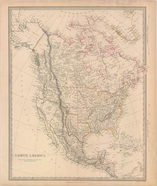
Lot 85
Schraembl, Franz Anton 1788 [On 4 Sheets] Generalkarte von Nordamerica samt den Westindischen Inseln This large-scale map of North America includes excellent detail of towns, political boundaries, roads, rivers, mines, Indian villages, and tribal territories. The map is a German-language edition of Emmanuel Bowen and John Gibson`s An Accurate Map of North America Describing and Distinguishing the British, Spanish and French Dominions on this Great Continent , which was first published in 1763 to illustrate the seat of the French and Indian War. Hundreds of settlements and Indian villages are located, with interesting notations referring to native tribes and historical events. A number of roads are shown on the map stretching all the way to New Mexico and Neu Navarra. There are two interesting inset maps. One shows the discoveries of Father Eusebius Kino in the Southwest that proved that California was not an island. The other illustrates the ongoing search for a Northwest Passage, showing Baffin and Hudson Bays with the fictional Lake de Fonte (See de Fonte) reaching nearly to Baffin Bay. The title cartouche also credits Thomas Pownall`s map of the Middle British Colonies, updated from Lewis Evans` map, with valuable geographic knowledge of the Ohio River Valley. The routes of the Spanish treasure galleons are shown throughout the Caribbean and Gulf of Mexico. The map is adorned with a rococo cartouche containing distance scales and a legend, and a decorative title cartouche featuring a female figure representing America and two cherubs. Engraved by Johann Stenger. Printed on four sheets, as issued without centerfolds; size varies slightly. Full sheets measure 36 x 25.3"" (bottom two sheets) and 38.5 x 25.3"" (top two sheets). 23"" W x 19.9"" H Nice impressions with slightly faded original outline color and a couple of small, unobtrusive spots. Printed on heavy, watermarked paper with the most generous margins we`ve ever seen.
Lot 95
SDUK Society for the Diffusion of Useful Knowledge, 1843 North America Detailed and finely engraved map that portrays an Independent Texas, with Mexico controlling Nueva California. The boundary between Canada and the United States is left unengraved, leaving the ownership of Oregon Territory (here labeled Columbia) unknown, which is unusual for a British map. Filled with well-developed topography, the map names numerous forts, trading posts, Indian tribes and locates L. Youla roughly near the Great Salt Lake with the American Fur Depot on its eastern shore. The R. Buenaventura extends to the Pacific from two branches, one originating from a large swamp in the Great Basin. The course of the Snake River is fairly accurate, but the Colorado River originates too far north and rushes to the Sea of Cortez in a straight line. Locates the 3 buttes in present-day Idaho -- important landmarks on the Oregon Trail. Lake Michigan retains its erroneous elongated shape. Distance scales outside of border give English Miles and Spanish Leagues. Engraved by J. & C. Walker and published by Chapman & Hall. 12"" W x 15"" H Original outline color with pleasant even-age toning.

Lot 109
Bellin, Jacques Nicolas 1744 Karte von dem Eylande Terre-Neuve... Fine copper engraved chart of Newfoundland, with the coast of the mainland at upper left. Blank interior, but there is good detail along the coastlines with scores of place names. The Strasse von Bell` Isle and part of the Gulf of St. Lawrence are noted. Shoals and fishing banks are indicated through full stippling in the sea, with soundings marked. There are two scales of miles at lower left. Dated 1744, but published in 1756 in the German edition of Bellin`s Histoire et Description Generale de la Nouvelle France by Arkstee & Merkus. 14.1"" W x 11.3"" H Issued folding, now pressed on watermarked paper with a few light stains and offsetting with a binding trim at left that has been replaced with old paper.

Lot 128
Bonne, Rigobert 1774 Partie du Nord de l`Amerique Septentrionale, pour Servir a l`Histoire Philosophique et Politique This attractive map of the eastern part of North America shows the British colonies confined along the eastern seaboard with French Louisianne and Canada taking up the interior. In the upper left is a series of rivers and lakes purportedly connecting Hudson Bay with la Mer de l`Ouest (Sea of the West). Features include the notation of the Natchitoches tribe in Louisiana Territory, along with numerous additional native tribes. Three distance scales and a fine shield-style cartouche embellish the composition. Engraved by Andre. 9.3"" W x 12.6"" H Issued folding on watermarked paper with faint offsetting. There is a binding trim at right and an associated 5"" binding tear that has been closed on verso with old paper.

Lot 145
Duvotenay, Thunot 1846 Etats-Unis This interesting map of the United States shows Mexico encompassing the majority of the Southwest and California. Texas is shown as an independent Republic. Most of the states east of the Mississippi River are named and outlined, except for Wisconsin, which is called District Huron. Besides Missouri, Arkansas, Louisiana, and Texas, land west of the Mississippi River is separated into regions, including District of the Mandines, District of the Osages, District of the Ozark, District of the Sioux, and District of the Oregon. Canada is called Nouvelle Bretagne. The map includes decorative borders with graphic elements in the corners and four distance scales. 12"" W x 8.8"" H A nice impression with light scattered foxing.

Lot 195
Bonne, Rigobert 1780 Carte de la Partie Sud des Etats Unis de l`Amerique Septentrionale Attractive and concise copper-engraved map that covers the states of Virginia, North and South Carolina, and Georgia in the new United States. All settlement is confined east of the Appalachians with les Cherokees the only note in the otherwise blank region west of the mountains. There are four distance scales located on the left side of the map. 12.3"" W x 8.3"" H There is faint offsetting and a few small stains in the image. To the right of the title are a small hole and 0.5"" tear that have been closed on verso with archival tape.
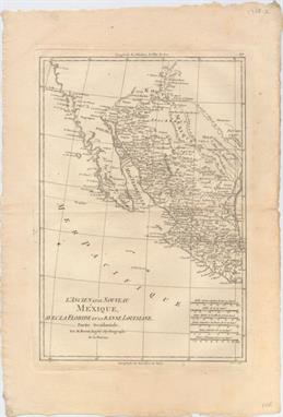
Lot 339
Bonne, Rigobert 1780 L`Ancien et le Nouveau Mexique, avec la Floride et la Basse Louisiane, Partie Occidentale This handsome map covers the region of present day southern California, Arizona, New Mexico, Texas and Mexico. Excellent detail, particularly of the Jesuit missions in Mexico and the Southwest, and of the numerous Indian tribes. The map locates San Diego, Santa Fe, Taos, Acapulco, Cabo St. Lucas and many towns along the Sea of Cortez and Baja Peninsula. Six distance scales at lower right. 9.3"" W x 13.5"" H On watermarked paper with faint offsetting and one small rust spot.

Lot 365
Robert de Vaugondy/Delamarche, 1785 Nouvelle Espagne, Nouvelle Mexique, Isles Antilles This attractive, small map was reissued by Delamarche, who was the successor to the Robert de Vaugondy family of mapmakers. It details the southern portion of North America, Central America, the West Indies and the northern tip of South America. The Azores are represented in an inset at the top right, and below the scales of miles is an additional title: ""les Audiences de Guadalahara, de Mexico, et de Guatimala, forment Le Mexique ou Nouvelle Espagne."" Engraved by E. Dussy. 12"" W x 9.5"" H Watermarked paper with some extraneous creases in left blank margin.

Lot 414
Hondius/Blaeu, 1635 Peru Beautifully engraved map based on the cartography of Hessel Gerritsz. The map covers the Pacific coast of South America from Ecuador as far south as the Atacama Desert in the northern reaches of Chile. It includes the Potosi silver mines, Titicaca, Cusco, Quito and numerous other towns and villages. The dramatic strapwork cartouche incorporates both the title and the distance scales. A large compass rose orients the map with north to the left. It is further decorated with four Spanish galleons and three sea monsters. This is one of the plates that Blaeu acquired from the widow of Jodocus Hondius in 1629. French text on verso. 19.4"" W x 14.9"" H Nice impression and color on watermarked paper with a faint extraneous crease adjacent to the centerfold and two small worm tracks near center of map that have been professionally repaired.

Lot 434
Bonne, Rigobert 1780 Carte des Isles Canaries, avec l`Isle de Madere, et Celle de Porto Santo This copper engraved map of the Canary Islands includes the islands of Porto Santo, de Madere, Tenerife, Palme, de Fer, de Canarie and Fortaventure. There are three distance scales including French leagues, marine leagues and Spanish leagues. 8.4"" W x 12.7"" H On watermarked paper with faint toning along the centerfold, two tiny worm holes, and a hint of offsetting.

Lot 457
Delisle/Buache, 1772 Les Isles Britanniques ou sont le Rme. d`Angleterre Tire de Sped Celuy d`Ecosse... This is Buache`s reissue of Delisle`s influential map of the British Isles that was first published in 1702. It is based on the foremost authorities: Speed for England and Wales, Pont for Scotland, and Petty for Ireland. The bottom right shows the coasts of the Netherlands, Belgium, and northern France and at the upper right is the southern tip of Norway. The important fishing banks in the North Sea are prominently illustrated and De Kimmen ou le Borneur traces what is now known to the edge of the European continental shelf. The note at lower left explains that Delisle doubts the existence of the islands of Brasil and Assmanda, which appeared on earlier maps. The large title cartouche incorporates mermen, fishing nets, sea birds and sea monsters and is surmounted by Neptune. Another decorative cartouche contains five distance scales flanked by hunting dogs. This is the seventh state, issued just before Buache`s death. 24.1"" W x 18.5"" H On watermarked paper with printer`s ink residue concentrated at the top of the centerfold.

Lot 467
Morden, Robert 1695 Norfolk ""This map of Norfolk is an early county map to show the local roads. The county is divided into """"Hundreds"""" (sometimes abbreviated as Hund on the map), an old English term for an area that would support a hundred families. It locates towns, buildings, forests, rivers, bridges and parks, which are noted by fenced areas. There is a decorative cartouche and three different distance scales. Sold by Abel Swale, Awnsham & John Churchil. Engraved by John Sturt. Morden was one of the first English cartographers to show longitudes measured from the meridian of St. Paul`s Cathedral (shown in degrees at the bottom of the map) and time in minutes measure locally from the sun (shown at the top). The roads on his maps are based on Ogilby`s earlier survey. The Britannia was first published by historian William Camden (1551-1623) in 1586. After the publication of the final edition of Britannia in 1637, the work was not published again until 1695 when Gibson revised and translated the text from the original Latin and included fifty maps, mostly of the English counties, prepared by Robert Morden, replacing the outdated maps of Christopher Saxton."" 23"" W x 14.7"" H A clean, bright example with a tiny tear entering the top border that has been professionally repaired. Issued folding, now pressed and partially trimmed to neatlines at left, top and right.

Lot 510
Ottens, Reiner and Joshua 1730 Carte Nouvelle du Royaume de France Divise en toutes ses Provinces et ses Acquistions... A handsome map of France showing the country divided into provinces. The map is boldly engraved with good detail throughout. The title cartouche incorporates the royal coat of arms and several distance scales. A panel at right displays the twelve coats of arms of the ancient governments, and includes the subdivided regions within each. An alternate Latin title, ""Galliae Regnum in Omnes suas Provincias Accurate Divisum"", can be found in the upper margin. This map was originally published by Pieter Husson in 1708. 23.3"" W x 19.1"" H Original color with a few light stains and an archivally repaired centerfold separation that enters 2"" into map at bottom.

Lot 533
Chanlaire & Mentelle, 1797 Carte de la Hongrie, de la Transilvanie et des Pays Adjacents Appartenants a la Maison d`Autriche Nicely detailed map centered on present day Hungary and Romania. There is good detail of rivers and mountains, and hundreds of towns and cities are identified, including Vienna, Graz, Belgrade, Krakow, and Budapest, here still split across the banks of the Danube as Bude and Pest. Includes five distance scales. 16.7"" W x 13"" H On bluish paper.

Lot 543
Blaeu, (Family) 1643 Zurichgow et Basiliensis Provincia This fine map of the northern part of Switzerland includes Zurich, Schaffhausen, Basel, and Solothurn. Decorated with a strapwork title cartouche and distance scales. French text on verso. 19.6"" W x 15"" H A nice impression on watermarked paper with old color that has been partially refreshed. There are some faint damp stains in bottom blank margin that enter map border in a few spots.

Lot 660
Blaeu, Johannes 1655 Suchuen, Imperii Sinarum Provincia Sexta The second landmark in the European mapping of China was the appearance of the Novus Atlas Sinensis in 1655. It was compiled by Father Martino Martini, an Italian Jesuit and produced by the most prominent Dutch cartographer of the time, Johannes Blaeu. Father Martini compiled the work based on Chinese sources between 1643 and 1650, and it greatly advanced European knowledge of the region including the astronomical positions of many cities and topographical features. It remained the standard geographical work on that country until the publication in 1737 of D`Anville`s Atlas de la Chine. This map of the Suchen province is decorated with two particularly graphic cartouches. The scales are flanked by mythical woodwose who represent the mighty Yangtze River, and a warlord and his guard stand behind the title cartouche. 19"" W x 15.7"" H Dark impression and wide margins with a few tiny centerfold separations and some light, uneven toning.

Lot 672
Bellin/Van Schley, 1752 Carte de l`Empire du Japon This is a reduced Dutch version of Bellin`s influential map made for Jesuit Father Pierre-Francois-Xavier de Charlevoix`s Histoire du Japon, published in 1758. Japan is presented on the Kaempfer/Scheuchzer model with several corrections to the coastlines, and individual provinces are delineated via engraved line. The Mer de Coree is shown to the west. The decorative rococo-style title cartouche includes two distance scales. Dutch title below the map image. Engraved by J. van Schley. 12.3"" W x 8.4"" H A crisp impression, issued folding and now pressed flat.

Lot 710
Bellin, Jacques Nicolas 1752 Carte de l`Inde en Deca du Gange Comprenant l`Indoustan &c. Suivant les Cartes les Plus Recentes... This map depicts the northern section of the Indian subcontinent and includes present-day Pakistan, Afghanistan, Nepal, and Tibet, in addition to northern India. It features regions, towns and cities, rivers, topographical detail, and a few geographical notes, and is adorned with two cartouches, containing the title and distance scales, respectively. 13.5"" W x 9.1"" H Issued folding with light scattered foxing and a hint of toning.

Lot 722
Sanson/Jaillot, 1685 L`Afrique Divisee Suivant l`Estendue de Ses Principales Parties, ou sont Distingues les uns des Autres les Empires, Monarchies, Royaumes, Estats, et Peuples... This striking map is Jaillot`s map of the continent and is a larger version of Sanson`s maps of 1650 and 1668. Engraved by Cordier, it is one of the early works in the collaboration between Sanson and Jaillot. The source of the Nile is shown emanating from two lakes below the equator. This map introduces a new depiction of the rivers south of these Ptolemaic lakes. The Zambeze River appears above the Zambere and Rio de Spiritu Santo, all of which flow into the Indian Ocean. A large section of South America is shown and two St. Helena islands appear - a common error in maps from this period. Six distance scales are presented on a drape-style cartouche. The very large and decorative title cartouche includes a tumult of figures, cornucopias, an elephant, a crocodile, a lion and an ostrich under the coat of arms of the Dauphin. Two sheets joined, as issued. This important map of the continent was copied by several other cartographers including Pieter Mortier and Marc Huguetan, who published their own edition of Jaillot`s Atlas Nouveau in 1692, with Jaillot`s imprint instead of their own. This is the second state, dated 1685. On two sheets, joined. 34.9"" W x 21.8"" H A fine impression on watermarked paper with a crease adjacent to joint and another crease in the Indian Ocean that has been professionally pressed and reinforced.


Lot 882
Revell, Matchbox and others, assorted plastic construction models, various scales: includes Sopwith Triplane, Camel, Nieuport 17, DH2, Spad XIII, S.E.5.A, Spitfire, Buffalo, Nieuport 28, Phantom, Fishing trawler, USS Flasher, and several others, all boxed. $$ TO BE INCLUDED IN OUR SALE ON THE 19TH FEBRUARY


Lot 167
BRITISH COMEDY: Selection of signed cards and postcard photographs by various British television comedy actors including Beryl Reid, Richard Briers, June Whitfield, Geoffrey Palmer, Anton Rodgers, Richard Wilson, Bill Owen, Melvyn Hayes, Nigel Hawthorne, Felicity Kendal, Bob Monkhouse, Ernie Wise, Kathy Staff, Maureen Lipman, Ian Carmichael, Ronnie Corbett, Leslie Phillips, Spike Milligan, James Bolam, Thora Hird, Rodney Bewes, Harry Secombe, Peter Sallis, Penelope Wilton, Dilys Laye, Geraldine McNulty, Prunella Scales, Julie Walters, Norman Wisdom, George Cole, Mollie Sugden, Eric Sykes etc. A little duplication. VG, 75


Lot 1181
19th Century mahogany apothecary cabinet, the plain hinged lid opening to reveal, green velvet lined and wooden compartmentalised interior, the sixteen compartments with contents of fifteen glass bottles and porcelain tile, the ivory escutcheon above single drawer with sunken brass loop handle, opening to reveal, compartmentalised interior and contents of glass mortar and pestle, scales, ten glass bottles, two sections with sliding lids, carrying handle either side, 29.5cm wide x 25cm high x 21cm deep


Lot 768
A multiple-scale slide-rule designed by Major Gen. Hannington, with nine fixed boxwood scales and a five-scale slide, set in a mahogany box with hinged lid; 68 cm wide, maker Aston & Mander Ltd. of London Condition Report Case badly stained with water damage to rear polish. Internally sound with some tarnish to brasswork
-
63836 item(s)/page