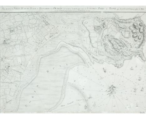

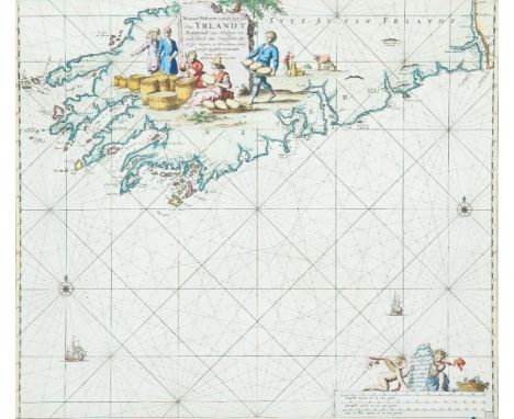
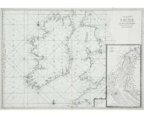
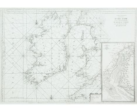
John Rocque (1705-1762)Chart of Dublin Bay and Plan of Dublin and Environs This is on four sheets, the bottom left sheet of which can be regarded as a town-plan of Dublin and the remainder as a map of the surroundings and a chart of Dublin Bay. The town-plan is a later state of No. 2 described in the Introduction, with the addition of river depths and the outer administrative boundary of the city.It shows the coast from Scotchman's Bay, Dalkey, northwards to include all of Howth Head, and inland to the centre of Phoenix Park and Finglas. The title is printed above the top of the two northern sheets and reads A Survey of the City Harbour Bay and Environs of Dublin on the same scale as those of London Paris & Rome By John Rocque Chorographer to his Royal Highness the Prince of Wales. Plan de la Ville, Havre, Baye & Environs de Dublin sur la meme Echelle que ceux de Londres, Paris & Rome par Jean Rocque chorographer du Roi avec des additions jusq a l'année 1773 par Mr Bernard Scalé. In the top left, in an irregular frame with the royal arms, is the dedication To His Royal Highness Prince Edward This Plan is most humbly inscribed by His Most Obedient Humble Servt. John Rocque. Below the left half of the frame are four scales: A Scale of an Irish Mile 320 Perches [= 168 mm.] A Scale of Yards 1000 [= 83 mm.] Echelle de Toises 500 [= 93 mm.] A Scale of an English Mile 320 Perches [= 132 mm.]. Alongside the scales is Published according to Act of Parliament and J.J. Perret Sculpt. Below the right half of the frame is an Explanation of the many symbols of boundaries and types of land use on the map. The bay has an indication of sand-banks and coastline with many soundings and 75 ships extending up the river Liffey. There is a decorative compass indicator of fish, nets and cornucopia showing true and magnetic north to the top left.There are three insets in the top left corner:1. Kildare House (120 x 210 mm.) showing the house and frontage on to Kildare Street, with various types of carriages arriving.2. The Barracks (120 x 208 mm.) with ladies and gentlemen strolling in front.3. The Royal Hospital (105 x 133 mm.) at Kilmainham, viewed from across the river.There is also an inset in the bay (195 x 197 mm.), depicted as if on a sheet, showing Dublin Anno 1610 Dublin comme il etait en 1610. The plan is flanked by two notes The Figures of the surroundings are Dotted thus . to distinguish them from those of the References. this Plan is Copyed from that Taken in 1610 and the Spelling the Same as at that Time. There are 69 numbers and a key for streets and buildings. Four sheets when joined. 1,395 x 1,010 mm. (4) For a full description see Abl Printed maps of Dublin R2. 1-4
We found 63909 price guide item(s) matching your search
There are 63909 lots that match your search criteria. Subscribe now to get instant access to the full price guide service.
Click here to subscribe- List
- Grid
-
63909 item(s)/page
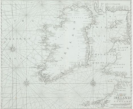
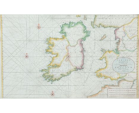
John Seller (1634-1697)Chart of Ireland and the Irish Sea This chart does not appear in the 1690 edition of The English Pilot, Southern Navigation, and is first seen in the 1701 edition. Three different plates were made, each occurring in two distinct states. The chart was replaced in an edition of c. 1769. It also occurs on its own in the Atlas Maritimus Novus or New Sea-Atlas by Mount and Page and in later editions of The English Pilot, Third Book.It shows all Ireland and the Irish Sea, with the British coast from Cornwall to the Mull of Galloway. The Ards peninsula and Island Magee are shown as separated from the mainland. The title (unframed) in the lower right corner reads A Chart of the Coasts of Ireland and Part of England. Below this is a scale of English and French Leagues 20 [= 80 mm.]. There is one compass rose showing north to the top and there are scales of latitude at each side. This edition from 1743. 555 x 445 mm.
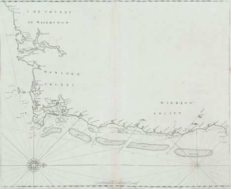
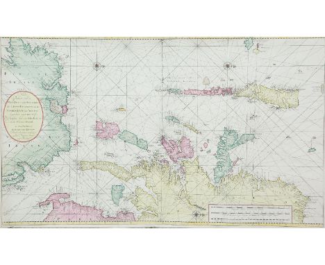
John Seller (1634-1697)Chart of the South-East Coast of Ireland This chart appears first in Seller's The English Pilot, Southern Navigation of 1690, and it was unchanged in editions up to 1715. Later editions used new plates.It shows the coast from Waterford to Dalkey and has no title. The scale in the lower centre reads A Scale of English and French Leagues 20 in a Degre 5 [= 102 mm.]. There is one compass rose, with 16 points, showing north to the right, and there are a scales of latitude at top and bottom. This edition from the first English plate without title or insert. 535 x 440 mm.
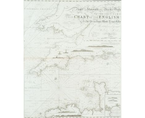
William HeatherChart of the St. George's and English Channels The dedication is unframed in the top centre and reads To the Right Honorable the Master, Wardens and Elder Brethren of the Trinity House this Chart of the English Channel Is most humbly dedicated by their obedient Servant William Heather. This was first produced as a separate chart in 1794 on three sheets which may be joined together. A new edition was printed in 1805.It shows the Irish coast from county Clare to Wexford, the British coast from Barmouth to Yarmouth and Europe from Britany to Haarlem in the Netherlands. There are detailed soundings round the coast and in the open sea, as well as tide and current marks and notes on the sea bottom. Below the frame is the imprint Published as the Act directs, July 12th 1794 by W. Heather, at the Navigation Warehouse, No. 157 Leadenhall Street, London. The navigational route through the English Channel is marked by a hand and two ships on the left sheet and two further ships on the middle sheet. There are scales of latitude and longitude east and west from London on all four sides, as well as three coastal profiles in the top centre. Magnetic variation on the left sheet is dated 1794 and there are four compass arrows showing north to the top as well as four ships. (1,890 x 775 mm.).There are six insets in the right sheet, each with one compass arrow showing north to the top:1. (142 x 345 mm.) entitled Portsmouth, with a Scale of Miles 5 [= 30 mm.].2. (100 x 120 mm.) entitled Sketch of the Situation of The Owner's Light by order of the Trinity House, 1794.3. (235 x 125 mm.) entitled Dartmouth, with a Scale of half a Mile 1/2 [= 45 mm.].4. (175 x 175 mm.) entitled Falmouth, with a scale of One Mile [= 30 mm.].5. (175 x 165 mm.) entitled Plymouth, with a scale of One Mile [= 30 mm.].6. (315 x 192 mm.) entitled Downs and Margate, with a Scale of Miles 3 [= 41 mm].1,890 x 775mm
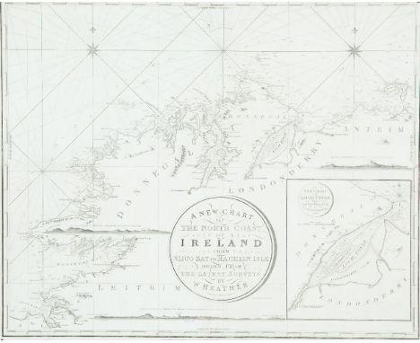
William HeatherChart of the North Coast of Ireland The title is in a circular frame in the centre and reads A New Chart Of The North Coast of Ireland From Sligo Bay to Rachlin Isle Drawn From The Latest Surveys for W. Heather. 1807. Below the title is J. Stephenson Engraver. Below the frame is the imprint London. Published as the Act directs, January 1st 1807, by William Heather, at the Navigation Warehouse, No. 157 Leadenhall Street. This is part of a series of three charts covering the north, west and south coast of Ireland, first produced in 1807. It overlaps chart V to include Sligo town.It shows the coast from Ballycastle and Rathlin Island, county Antrim, to Achris Head, county Sligo. There are scattered coastal profiles, notes on the sea bottom, numerous soundings and tide and current marks. There are also two compass roses showing north to the top and scales of latitude and longitude west from Greenwich, on all four sides. Magnetic variation is dated 1807.In the lower right corner is an inset (265 x 230 mm.) entitled A New Chart of Loch Foyle, being the Entrance to Londonderry with a Scale of Miles 6 [= 70 mm.] and one compass rose showing north to the top. 780 x 645mm.
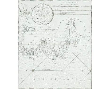
William HeatherChart of the West Coast of IrelandThis is part of a series of three charts covering the north, west and south coast of Ireland, first published in 1807. It overlaps chart IV to include Sligo town and butts on the chart VI to the south.It shows the coast from Sligo town to Mutton Island in Galway Bay.The title is in a circular frame in the centre and reads A New Chart Of The West Coast of Ireland. Drawn from The Latest Surveys by William Heather. 1807. This is part of a series of three charts covering the north, west and south coast of Ireland, first published in 1807. It overlaps chart IV to include Sligo town and butts on the chart VI to the south.It shows the coast from Sligo town to Mutton Island in Galway Bay. The title is in a circular frame in the centre and reads A New Chart of the West Coast of Ireland. Drawn from The Latest Surveys by William Heather. 1807 Below the title is Stephenson Engraver and below the frame is the imprint London. Published as the Act directs. January 1st 1807, by William Heather, at the Navigation Warehouse, No. 157 Leadenhall Street. There are scattered coastal profiles, notes on the sea bottom, tide and current marks and numerous soundings. There are also one and a half compass roses showing north to the left and scales of latitude and longitude west from Greenwich on all four sides. Magnetic variation is dated 1807. 625 x 785 mm.
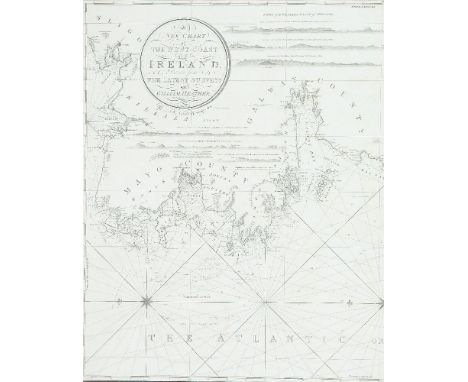
William Heather VChart of the West Coast of Ireland The title is in a circular frame in the centre and reads A New Chart Of The West Coast of Ireland. Drawn from The Latest Surveys by William Heather. 1807. This is part of a series of three charts covering the north, west and south coast of Ireland, first published in 1807. It overlaps chart IV to include Sligo town and butts on the chart VI to the south.It shows the coast from Sligo town to Mutton Island in Galway Bay. Below the title is Stephenson Engraver and below the frame is the imprint London. Published as the Act directs. January 1st 1807, by William Heather, at the Navigation Warehouse, No. 157 Leadenhall Stret. There are scattered coastal profiles, notes on the sea bottom, tide and current marks and numerous soundings. There are also one and a half compass roses showing north to the left and scales of latitude and longitude west from Greenwich on all four sides. Magnetic variation is dated 1807.State 3 (1833). There is no date in the title but the date in the title frame now reads Additions to 1833. The Norrie and Stephenson references in the frame are as before. The magnetic variation is undated. (625 x 785 mm.).
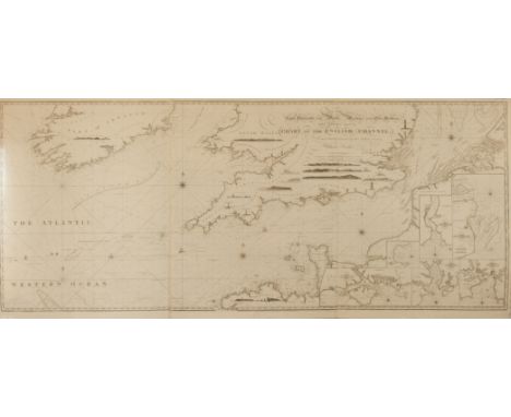
William Heather IChart of the St. George's and English Channels (1,890 x 775 mm.)This was first produced as a separate chart in 1794 on three sheets which may be joined together. A new edition was printed in 1805.It shows the Irish coast from county Clare to Wexford, the British coast from Barmouth to Yarmouth and Europe from Britany to Haarlem in the Netherlands. The dedication is unframed in the top centre and reads To the Right Honorable the Master, Wardens and Elder Brethren of the Trinity House this Chart of the English Channel Is most humbly dedicated by their obedient Servant William Heather. There are detailed soundings round the coast and in the open sea, as well as tide and current marks and notes on the sea bottom. Below the bottom border is the imprint Published as the Act directs, July 12th 1794 by W. Heather, at the Navigation Warehouse, No. 157 Leadenhall Street, London. The navigational route through the English Channel is marked by a hand and two ships on the left sheet and two further ships on the middle sheet. There are scales of latitude and longitude east and west from London on all four sides, as well as three coastal profiles in the top centre. Magnetic variation on the left sheet is dated 1794 and there are four compass arrows showing north to the top as well as four ships.There are six insets in the right sheet, each with one compass arrow showing north to the top:1. (142 x 345 mm.) entitled Portsmouth, with a Scale of Miles 5 [= 30 mm.].2. (100 x 120 mm.) entitled Sketch of the Situation of The Owner's Light by order of the Trinity House, 1794.3. (235 x 125 mm.) entitled Dartmouth, with a Scale of half a Mile 1/2 [= 45 mm.].4. (175 x 175 mm.) entitled Falmouth, with a scale of One Mile [= 30 mm.].5. (175 x 165 mm.) entitled Plymouth, with a scale of One Mile [= 30 mm.].6. (315 x 192 mm.) entitled Downs and Margate, with a Scale of Miles 3 [= 41 mm]. (3 sheets joined)1,890 x 775mm.
William Heather VIIIChart of the St. George`s and English Channels (1,910 x 790 mm.)There an unframed dedication to the top centre which reads To the Right Honorable the Master, Wardens and Elder Brethren of the Trinity House this Chart of the English Channel Is by Permission Most Respectfully Dedicated by Their Most Obliged and Grateful Servant William Heather. A New Edition 1815. Stephenson sculpsit. Church Street, Bethnal Green. This is another new version of the 1794 chart on three sheets, published in 1815.It shows the Irish coast from the river Shannon to Glasscarrick (that is, slightly less than before), and the Welsh coast from Barmouth as before, but rather more of the coast north of Yarmouth. Again the European coast is shown from Brittany to Haarlem. To the left is Drawn, Revised & Corrected by J.W. Norie, Hydrographer. Below the frame is the imprint London. Published as the Act directs, January 1st 1815 by Norie & Co. at the Navigation Warehouse, No. 157 Leadenhall Street. The navigational route through the English Channel is marked as before and there are scales of latitude and longitude on all sides. There are scattered coastal profiles, but lighthouses are confined to Devon. There are five compass roses with arrows showing north to the top. There are three scales as follows English and French Miles 60 to a Degree 60 miles [= 182 mm.], Duytche en Danish Mylen 15 in een Graadt 15 [= 78 mm.]2 and Swedish Miles 10 to a Degree 10 [= 80 mm.].There are 7 insets, each with a compass rose showing north to the top, as follows:1. (130 x 180 mm.), over Ireland, entitled A New Plan of Cork Harbour, Surveyed by M. Mackenzie, with a Scale of Nautical Miles 5[= 56 mm.].2. (145 x 380), grouped with the other insets in the lower right, entitled A New Chart of Portsmouth by Capt. Mackenzie, with a Scale of Miles 10 [= 70 mm.].3. (135 x 153 mm.), entitled A New Chart of Torbay by Lieut J. Wilson, with an scale of One Mile [= 25 mm.].3 sheets
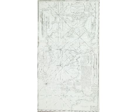
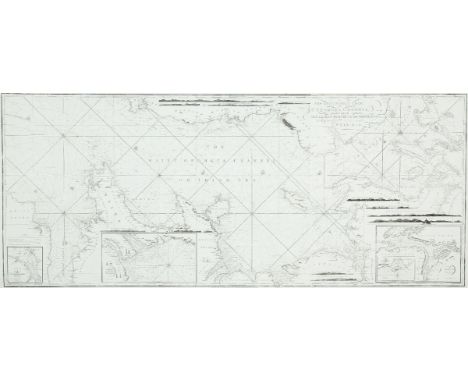
HuddartChart of the East Coast of Ireland and the Irish SeaThe title is in a scalloped frame with a cannon, flags, nets and an anchor, and reads A New and Original Hydrographical Survey of the North and St. George's Channel Extending from Arran to Caldy Island on the British Coast and from Skerries Port Rush to Bannow on the Irish Coast By Capt. Joseph Huddart London Published 12th May 1794 by Laurie & Whittle No. 53 Fleet Street.This is a reduced version of Huddart's chart of the area which was first published in 1779 by Sayer and Bennett. This version was published in 1794 by Laurie and Whittle on two sheets and was included in their Irish Coasting Pilot (1795). It was enlarged southwards by a small third sheet, to measure 1200 x 665 mm., and this form is the first chart in The North-about Navigator, published by Laurie and Whittle in 1818.It shows the whole Irish coast from Baginbun Head, county Wexford, to Portrush, county Antrim, and the British coast from Caldy Island in Pembrokeshire, to the Mull of Kintyre in Scotland, with detailed soundings round the coast and across the Irish Sea. In the lower right there is a Scale of Nautic Leagues 20 to a Degree 10 [= 120 mm.]. There are also, as in the larger-scale version of the chart, A Table of the Stream of Tide for every 1/2 Hour in the bottom centre, A Table of Time to be added to the end of the Stream in the bottom right corner, an Explanation of symbols in the centre, and a long passage of Remarks on the Chart of St. George's Channel .... Royal Admiral, Mother Bank, 31 March 1778, Joseph Huddart. There are scales of latitude along each side and of longitude, east and west from Dublin, along the upper and lower borders. There are two compass roses showing north to the top, and many coastal profiles on all sides.In the top right corner is an inset (120 x 110 mm.) entitled The Harbour of Lamblash in the Isle of Arran, with a scale of One Mile 3 [= 26 mm.]. (665 x 980 mm.).
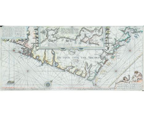
Janssonius, Johannes (1588-1664)Bookseller and publisher, produced his version of Blaeu`s Het Licht der Zeevaert in 1620. He also, with others, produced the Atlas Novus in 1650, in many languages, the fifth volume of which contains his chart of Ireland and the Irish Sea.A Chart of the South-east Coast of Ireland (1650)“Beschrijvinge der Zeecusten vande Suijd-sijde van Ierlant …..” and “Description des costes marines meridionales et Orientales d`Irlande ….”; long title in Dutch and French for this chart based on Blaeu`s chart of south-east Ireland. There is a large meridian bar above the scales and map number “16” in the lower right corner. From Het Licht der Zeevaert (1620). Verso blank. 540 x 250.
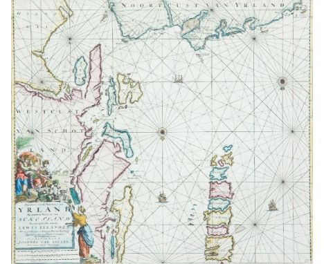
Johannes van Keulan (c. 1654-1715)Chart of the North Coast of Ireland and S-W Scotland Koeman No. 77. There is a boxed 17 in the lower right corner. It occurs in van Keulen's Zee-Fakkel from the first edition (1681) and in some of the editions of the Zee-Atlas from the English edition of 1682. It does not occur in the Zee-Fakkel of 1728 or later, one of the larger charts (VI or VII) being inserted instead.The chart shows the north Irish coast from Larne to Aran Island, and the Scottish coast from the Mull of Galloway to Skye and North Uist. The title in the lower left corner is loosely framed, surmounted by Flora and two hand-maidens, and at their feet is a horned satyr with sheep and goats. There is another female figure alongside the frame. The title reads Pascaart van de Noortcust van Yrland Als meede de Westcust van Schotland En een gedeelte van de Lewys Eylanden. Met al syn Diepten en Droogten Dus van Naukeurig Opgestelt en van Veel Fauten verbeetert, Met Priviligie voor 15 Iaar. T'Amsterdam By Joannes Van Keulen, Boekverkooper aan de Nieuwenbrugh. The scales are below the title and read Duytsche Mylen 15 voor een Graat 9 [= 115 mm.] Engelsche en Fransche Mylen 20 voor een Graat 12 [= 116 mm.] Spaansche Mylen 17 1/2 voor een Graat 11 [= 121 mm.]. There are soundings near Dunluce and in Lough Foyle, but more round the Scottish coast. There are two compass roses showing north at the bottom, and three ships, also scales of latitude along each side of the chart. (585 x 510).
Johannes van Keulan (c. 1654-1715)Chart of the South-West Coast of Ireland Koeman No. 80. There is a boxed 20 in the lower right corner. It occurs in van Keulen's Zee-Fakkel from the first edition (1681) to the last (1802), and in some of the editions of the Zee-Atlas from the English edition of 1682.The chart shows the south-west coast of Ireland, from the mouth of the river Shannon to Waterford. The title is in the top centre in a loose frame, surrounded by a milkmaid milking, one churning, and others carying and packing butter. Two fashionably-dressed men are standing nearby. The title reads Nieuwe Pascaert, van de suyt syde van Yrlandt Beginnende van Blasques tot ande Hoeck van Waterfoort, Met al syn diepten en Droochten Naeu keurigh opgestelt, en van veel fouten verbetert. Met Priviligie voor 15 Iaar. The publisher's imprint is separate, on a tablet held up by cherubs in the lower right corner of the chart, reading 't Amsterdam by Iohannus van Keulen boeck en Zee kaert verkoper an de Nieubrug Inde gekroonde Lootsman. Below this are the scales Duytsche mylen 15 in een graet 13 {= 172 mm.] Spaensche mylen 17 1/2 in een graet 15 [= 172 mm.] Eng. en Fra. mylen 20 in een graet 17 [= 170 mm.]. There are coastal soundings round Kenmare, Bantry, Kinsale and Cork. There are two compass roses showing north at the top, and two ships, also scales of latitude on either side of the chart.
Johannes van Keulen (c. 1654-1715)Chart of Ireland and the Irish Sea Koeman No. 298. It occurs first in van Keulen's Zee-Atlas of 1718 and then in De Nieuwe Groote Lichtende Zee-Fakkel of 1734 and in some subsequent editions.The chart shows all of Ireland and the coast of Great Britain from Land's End to Ayr. In Ireland the Ards peninsula, Island Magee, the tip of Innishowen and Mullet are all shown as islands. The title, in a plain oval frame over Wales, reads Nieuwe Paskaart van Ierland en de West kust van Engeland Vervattende in sig St. Joris en het Verkeerde Kanaal, Gelegt naer de Nieuwste ondervinding van ervaren Zeelieden. The New sea Map of Ireland and the West Coast of England containing St. George and the Channel of Bristol made according the newest experience of Expert Mariners. The publisher's imprint is in a rectangular frame with scroll-like ends, in the top right corner, and reads te Amsterdam by Joannes Van Keulen Boek en Zeekaart verkooper aan de Nieuwen Brug met Privilegie. The scales are in the lower right corner reading Duytsche Mylen van 15 in een Graad 25 [= 184 mm.] Fransche Mylen van 20 in een Graad 33 1/3 [= 184 mm.] Engelsche Mylem van 60 in een Graad 100 [= 184 mm.] Schotse Mylen van 50 in een Graad 40 [= 91 mm.] Ierse Mylen van 48 in een Graad 40 [= 91 mm.]. There are soundings scattered round all the coasts as well as four compass roses showing north at the top and scales of latitude on either side of the chart. (977 x 595 mm.).
Johannes van Keulen (c. 1654-1715)Chart of the North Coast of Ireland and W. Scotland Koeman No. 244. It occurs first in van Keulen's Zee-Fakkel, Part 2, of 1728 (Dutch edition) as a replacement for chart III, but not in the late editions where chart VI was used instead.The chart shows the north coast of Ireland from the middle of the Ards peninsula to north Sligo and the west coast of Scotland, including the Hebrides and St. Kilda. The Ards peninsula, Island Magee and the tip of Innishowen are all shown as islands. The title, in a plain oval frame over Ireland, reads Nieuwe Paskaart van de West Kust van Schotland, de Lewys Eylanden en de Noord Kust van Yrland, beginnende van C Wrath of de Noordelykste hoek van Schotland tot in het St. Ioris Kanaal. te Amsterdam by Gerard van Keulen Boek en Zeekaart verkooper aan de Nieuwen brugh met Previlegie. The scales are in the lower right corner in a plain rectangular frame and read Duytsche Mylen 15 in een Graad 15 [= 243 mm.] Englisch Leagues 20 for Degree. Lieues de France 20 par Degrez 20 [= 243 mm.] Schotse Mylen van 50 in een Graad 24 1/2 [= 120 mm.] Ierse Mylen van 48 in een Graad 24 [= 122 mm.]. There are scattered soundings round the Irish and Scottish coasts, three compass roses showing north to the right, and scales of latitude along the upper and lower borders. (1010 x 605 mm.).
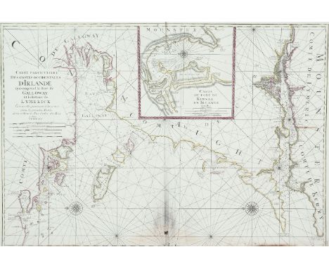
Mortier, Pieter IIIChart of Galway Bay and the Shannon Estuary (865 x 595mm)This chart is from Le Neptune Francois, published by Pieter Mortier and Hubert Jaillot in Amsterdam in 1693. Carte Particuliere Des Costes Occidentales D'Irlande Qui comprend la Baye de Galloway Et la Riviere de Lymerick. Comme elles paroissent a basse mer dans les grands Marees. Levee et Gravee Par Ordre du Roy. A Paris. 1693. Below this are the scales Echelles Lieues de France et d'Angleterre a 20 par degre 4 [= 146 mm.] Lieues d'Allemagne a 15 par degre 3 [= 146 mm.] Lieues d'Espagne a 17 1/2 par degre 3 [= 127 mm.] Milles d'Irlande 8 [= 122 mm.] Toises 1000 [= 128 mm.]. Echelles Mille d'Irlande 1 [= 134 mm.] Mille d'Angleterre 1 [= 108 mm.] Toises 1000 [= 104 mm.] Quart de Lieue de France a 20 par degre 1 [= 82 mm.].

Depot de la Marine VII. Chart of the West Coast of Ireland (530 x 765mm)This chart is in the volume of Le Neptune Francois of 1803, covering the British Isles, based on an earlier chart of Captain Joseph Huddart (chart V).It shows the west coast of Ireland from Mullaghmore, county Sligo, to Kerry Head, county Kerry. The title is in an oval frame in the centre right and reads Carte Particuliere de la Cote Ouest d'Irlande depuis Sligo jusqu'a L'Embouchure du Shannon Tiree des Cartes du Cape. Joseph Huddart et Publiee Par Ordre du Contre-Amiral Decres Ministre de la Marine et des Colonies au Depot General de la Marine en l'An XII. Below this is a note on the soundings. In the lower right corner is a scale of Lieues Marines 10 Lieues [= 171 mm.] and beside this is the circular mark of the Depot Gal. de la Marine R.F. and below both, outside the frame, is Prix Deux Francs. There is one compass indicator with an arrow showing north to the top, and scales of latitude on each side.
Charles PeneA Chart of Northern Ireland and Scotland (1753)“Carte de la Mer d`Ecosse Contenant les Isles et Costes Septentrionales et Occidentales d`Ecosse et les Costes Septentrionales d`Irlande.” From Bellin`s Le Neptune Francois. No watermark but addition of various scales (1753). 870 x 605.

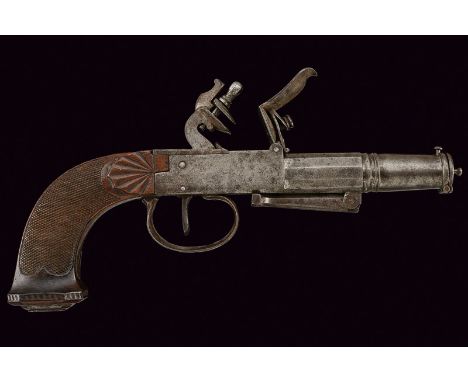
A flintlock lighter dating: first quarter of the 19th Century provenance: Europe With tubular, two-stage magazine for the tinders, faceted and round, with ring at the girdle and another ring by the mouthpiece similar to a moulded muzzle, provided with a cover which can be opened by pressing the small button on the back, with handle. Box-lock type mechanism with rear hammer (detachable upper jaw) and batterie, trigger with trigger guard; checkered, wooden grip, chiselled with shell on the sides and hollow scales on the back, iron butt-plate. Provided with a folding pedestal in the lower part. Interesting lighter with magazine for the tinders shaped as a barrel which makes it look like a pocket pistol. dimensions: length 22 cm.
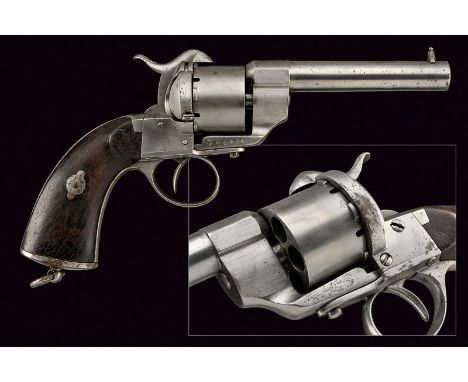
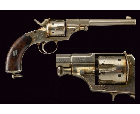
A 1861 model pin-fire revolver dating: third quarter of the 19th Century provenance: Kingdom of Italy Round, rifled, 11 mm cal. barrel with foresight; smooth, six-shot cylinder, frame with Lefaucheux mark (slightly visible), serial number "LF 64XXX"; pin-fire mechanic (to be checked). Grip with smooth, wooden grip scales and a ring for the strap. dimensions: length 28 cm.
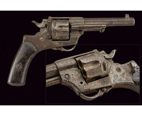
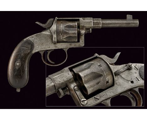
A very rare modified 1874 model revolver dating: 1875-1890 provenance: Kingdom of Italy Octagonal, rifled, 11 mm cal. barrel with foresight. Grooved, six-shot cylinder (functioning mechanic, to be cleaned), frame featuring remains of the mark "GLISENTI BRESCIA" on the left and remains of a stamp, on the right side remains of a stamp and the serial number "2xxx". Folding trigger, loading gate, extractor. The ring for the strap is missing. Wooden grip scales with remains of checkering. Modified version of model 1874 revolver adapted to the mechanic structure of Bodeo. Created in a small number of pieces. See "Pistole Militari Italiane 1814-1890" by Luciano Salvatici, Editoriale Olimpia, 1985; page 131 with picture. dimensions: length 25,5 cm.
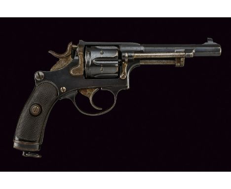
A 1879 model Reichsrevolver dating: 1875-1890 provenance: Germany Round, rifled barrel with foresight, octagonal base, mark of the caliber "10,55"; six-shot cylinder with fuller; frame dated "1881", serial number "8xxx" and safety lock; smooth, wooden grip scales, a ring for the strap. Functioning mechanic. Nickel-plated. dimensions: length 33,5 cm.
A 1883 model Reichsrevolver dating: 1875-1890 provenance: Germany Round, 10 mm cal. barrel with foresight, octagonal at the base. Grooved, six-shot cylinder; frame with remains of marks and stamps, safety lock and loading gate. Pitting on the surface. Grip without the ring for the strap; smooth, wooden grip scales. dimensions: length 25 cm.

A rare 1887 model Husquarna revolver dating: 1875-1890 provenance: Sweden Octagonal, rifled, 7.5 mm cal. barrel with foresight; grooved, six-shot cylinder, frame marked "HUSQUARNA", all parts featuring the serial number "44xx", keeping most of the finishing, small areas of pitting. Checkered, wooden grip scales. dimensions: length 26 cm.
A 1882 model Schmidt revolver dating: 1875-1890 provenance: Swiss Octagonal, 7.5 mm cal. barrel with foresight, serial number "P1xxxx" and stamp depicting a cross. Six-shot cylinder with fuller, frame with serial number and coeval stamps, the hammer and the trigger en suite. Grip with grip scales of hard rubber, a ring for the strap. First type. dimensions: length 23 cm.
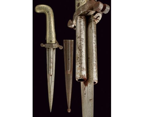
Dumonthier type double barrelled percussion knife-pistol dating: mid-19th Century provenance: France Straight, double-edged blade, a fuller at the centre, featuring fine engravings on the entire length; on the sides of the blade two smooth, round, 9 mm cal. barrels; steel hilt, the parry quillons consisting in the hammers, the quillon-block with the pistons; provided with two foldaway triggers; curved, iron grip (pistol-shaped) enclosing the springs and the mechanism; German silver grip scales engraved with floral motifs. Iron scabbard featuring remains of engravings. dimensions: length 35 cm.
-
63909 item(s)/page