We found 63833 price guide item(s) matching your search
There are 63833 lots that match your search criteria. Subscribe now to get instant access to the full price guide service.
Click here to subscribe- List
- Grid
-
63833 item(s)/page


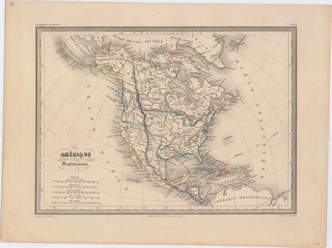
Lot 92
Amerique Septentrionale This attractive map features the Independent Republic of Texas. In Texas, the named towns include San Antonio, Franklin, Austin and Natchitoches. This French map portrays the United States extending well into British Columbia, cartographically taking the side of the United States as the French normally did at this time in history. Alaska is Amerique Russe and all of Canada is Nouvelle Bretagne. Mexico is in control of the entire Southwest. The map presents some basic detail of Indian tribes, the river systems and some place names along the eastern and southern coastline. Fancy titling and five distance scales. A hint of toning and just a few tiny spots. 8.6 W x 12 H Fremin, A. R. 1840

Lot 93
North America Detailed and finely engraved map that portrays an Independent Texas, with Mexico controlling Nueva California. The boundary between Canada and the United States is left unengraved, leaving the ownership of Oregon Territory (here labeled Columbia) unknown, which is unusual for a British map. Filled with well-developed topography, the map names numerous forts, trading posts, Indian tribes and locates L. Youla roughly near the Great Salt Lake with the American Fur Depot on its eastern shore. The R. Buenaventura extends to the Pacific from two branches, one originating from a large swamp in the Great Basin. The course of the Snake River is fairly accurate, but the Colorado River originates too far north and rushes to the Sea of Cortez in a straight line. Locates the 3 buttes in present-day Idaho -- important landmarks on the Oregon Trail. Lake Michigan retains its erroneous elongated shape. Distance scales outside of border give English Miles and Spanish Leagues. Engraved by J. & C. Walker and published by Chapman & Hall. Light toning and with some minor soiling confined to the blank margins. 15 W x 12 H SDUK Society for the Diffusion of Useful Knowledge, 1843

Lot 159
Carte de la Partie Sud des Etats Unis de l`Amerique Septentrionale Attractive and concise copper-engraved map that covers the states of Virginia, North and South Carolina, and Georgia in the new United States. All settlement is confined east of the Appalachians with les Cherokees the only note in the otherwise blank region west of the mountains. There are four distance scales located on the left side of the map. On watermarked paper with light offsetting and a printer`s crease at bottom left. 8.4 W x 12.4 H Bonne, Rigobert 1780

Lot 168
Carte de la Louisiane, et de la Floride This handsome map of the American Southeast and the Mississippi River Valley extends from Charleston, South Carolina west to include New Orleans and north into southern Illinois. In this French-produced map Louisiana extends to the Appalachian Mountains bordering the southern colonies. The Mississippi and Ohio Rivers are well delineated. Florida is shown with its panhandle extending west to include Mobile and Biloxi. Locates Charles Town, Savannah, St. Augustine, Mobile, Pensacola and several far western settlements and forts in the frontier. A small inset provides details of the Missouri River. Six distance scales fill the Gulf of Mexico. Engraved by Andre. Minor soiling with a bit of offsetting along the centerfold and a closed edge tear confined to the left blank margin. 12.7 W x 8.4 H Bonne, Rigobert 1780

Lot 250
Preliminary Chart of Gloucester Harbor Massachusetts from a Trigonometrical Survey... A very attractive chart produced by the Coast Survey, fully and beautifully engraved with excellent coastal detail and the city of Gloucester shown in a grid plan. The water is filled with hundreds of soundings, hazards, sea-bottom type identifiers, and buoys. Sailing directions, information about the tides, and a key for the abbreviations used for seafloor type classification appear beneath the title. A chart with the location of two lighthouses, a note on various hazards, and two distance scales run along the chart`s bottom. Drawn by L. Daser and W.T. Martin and engraved by G.B. Metzeroth and J.L. Hazzard. Produced under the direction of A.D. Bache. Issued folding, now flat, with a tiny hole at a fold intersection and some faint toning along the folds. The map has been remargined at bottom left with border replaced in facsimile. 17.5 W x 13.9 H U.S. Coast Survey, 1854

Lot 312
L`Ancien et le Nouveau Mexique, avec la Floride et la Basse Louisiane, Partie Occidentale This handsome map covers the region of present day southern California, Arizona, New Mexico, Texas and Mexico. Excellent detail, particularly of the Jesuit missions in Mexico and the Southwest, and of the numerous Indian tribes. The map locates San Diego, Santa Fe, Taos, Acapulco, Cabo St. Lucas and many towns along the Sea of Cortez and Baja Peninsula. Six distance scales at lower right. On watermarked paper with light offsetting. 13.5 W x 9.3 H Bonne, Rigobert 1780

Lot 342
Carte Generale des Iles Antilles, d`une Partie du Mexique, des Etats-Unis & de l`Amerique Meridionale... This attractive chart covers the far southern United States, Mexico, Central America, the West Indies and the northern coastline of South America. The map is highly detailed along the coastlines with mainly rivers and topography noted inland. A key in the bottom corner identifies the possessions of the Spanish, French, English, Danish, Dutch and Swedish. Decorated by fancy tilting, four distance scales, and a keyboard style border. The embossed publisher`s stamp appears below the title. Dissected and backed on linen with just a few tiny, insignificant spots in the image. 14.7 W x 20.4 H Brue, Adrien Hubert 1821
![Cuba Insula [on sheet with] Hispaniola Insula [and] Ins. Iamaica [and] Ins. S. Ioannis [and] I.S. Margareta This is a reduce](http://lot-images.atgmedia.com/SR/36385/2906594/348-20145813436_468x382.jpg)
Lot 348
Cuba Insula [on sheet with] Hispaniola Insula [and] Ins. Iamaica [and] Ins. S. Ioannis [and] I.S. Margareta This is a reduced version of the Mercator/Hondius folio map of important islands in the West Indies. This later re-issue of the Cloppenburgh plate omits the moiré pattern in the sea, and features several additions, including cartouches added to the distance scales and several sailing ships decorating the map. There is a small amount of printer`s ink residue mostly concentrated at the top of the sheet and a few insignificant spots. 7.4 W x 10 H Mercator/Cloppenburgh, 1676

Lot 400
Carte des Isles Canaries, avec l`Isle de Madere, et Celle de Porto Santo This copper engraved map of the Canary Islands includes the islands of Porto Santo, de Madere, Tenerife, Palme, de Fer, de Canarie and Fortaventure. There are three distance scales including French leagues, marine leagues, and Spanish leagues. Issued folding on sturdy paper with a few faint spots. 12.6 W x 8.3 H Bonne, Rigobert 1787

Lot 449
L`Irlande Divisee par Provinces Civiles et Ecclesiastiques Decorative map with rococo-style cartouche and two distance scales. Good detail throughout the island particularly with towns, rivers and coastlines. Enclosed with an ornate picture-frame border. A strong impression with original color, some faint color offsetting, and a small rust stain confined to the lower blank margin. 10.8 W x 12.3 H Brion de la Tour/Desnos, 1766

Lot 458
Scandinavia Complectens Sueciae Daniae & Norvegiae Regna ex Tabulis Beautiful folio map of Scandinavia, including the Baltic States with a portion of northeastern Russia, locates Moscow, S. Michael Archangel, Konigsberg, and more. Elaborate figurative cartouche features a herald, putti, angels, a lion, and royal coat-of-arms. Four distance scales at upper right. A nice impression with moderate toning along the centerfold, faint offsetting, and several small damp stains confined to the blank margins. 19 W x 22 H Homann, Johann Baptist 1720

Lot 464
Gothia This map of the southern part of Sweden depicts the forested topography, lakes and numerous place names. The large cartouches have a military theme with Mars and his fierce hounds atop the title. The map is further embellished with several sailing ships and coats of arms. This is the first state with a scales cartouche at lower left. French text on verso, published between 1643-50. A fine impression on watermarked paper with original color that has been partially refreshed. There is very light toning and faint damp stains in bottom blank margin that just enter map border in a few spots. 16.4 W x 20.8 H Blaeu, (Family) 1643

Lot 478
Carte de la Hollande Prise en General Contenant les Sept Provinces Unies des Pays Bas This handsome map of Holland shows the area from the islands off the coast of Friesland and Embden in the north to Ostende and Dusseldorf in the south. Provinces, rivers, and towns are identified, including major cities such as Amsterdam, Rotterdam, the Hague, and Haarlem. Includes three distance scales. Engraved by Andre. A crisp impression with two tiny wormholes and a hint of offsetting. 9 W x 12.8 H Bonne/Raynal, 1780

Lot 504
L`Andalousie avec les Royaumes de Grenade et de Murcie This handsome map of Andalusia spans from the Strait of Gibraltar up to the border of the now-defunct New Castile region of Spain. It shows the area`s many mountains in addition to several towns and cities in the region, such as Seville, Granada, Malaga, Murcia, Cordoba, and Ciudad Real. Includes six distance scales. Engraved by Andre. There are a few faint damp stains in the image and minor offsetting especially evident along the centerfold. 9.2 W x 14 H Bonne, Rigobert 1780

Lot 512
Alsatia Landgraviatus, cum Suntgoia et Brisgoia Large map of Alsace based on the work of Gerard Mercator. It covers the region surrounding the Rhine River from Basel in the south to Strasbourg in the north, and extends as far west as Granville and St. Die. Decorated with an elaborate title cartouche and two distance scales. French text on verso, published between 1643-50. Two sheets joined, as issued. Watermarked paper with original color that has been partially refreshed and very light printer`s ink residue. There are some chips in the left blank margin that have been professionally repaired, with a small amount of neatline replaced in facsimile. 15.8 W x 31.7 H Blaeu, Willem 1643

Lot 532
A New Mapp of the Estates of the Crown of Poland. Containing: the Kingdom of Poland the Dutchies & Provinces of Prussia. Cuiavia. Mazovia. Russia Nigra. Lithuania. Podolia. Volhinia the Ukraine &c. This uncommon map covers the region from the Baltic Sea and the eastern edge of Germany to portions of Belarus, Ukraine, and Russia, extending south to the Black Sea. There is excellent topographical detail, and major cities such as Krakow, Warsaw, Vienna, Kiev, and Minsk are named. The striking title cartouche features the Polish coat-of-arms, putti, soldiers, and a farmer. Another cartouche at top right contains information about where the map was sold and a key indicating the symbols used for towns, universities, towns of note, etc. The distance scales are flanked by putti. Engraved by Francis Lamb. A dark impression with original color, light soiling, and minor offsetting. There are damp stains along the edges, some of which enter the image at top, and some chips and short edge tears in the blank margins, most of which have been closed with archival tape. A centerfold separation that enters 1"" into map at bottom has been archivally repaired. 17.3 W x 21.9 H Morden, Robert 1690

Lot 556
Italie Moderne This intricate map of Italy shows political divisions, roads, cities, towns, and topography. The map covers the area from eastern France and southern Switzerland, across the Adriatic Sea (here called Golfe de Venise) to present-day Croatia, and south to the tip of Africa. Corsica, Sardinia, and Sicily are shown, and Mt. Etna is identified. There are four distance scales flanking the title above the map. Engraved by Andre. On a sturdy sheet with faint scattered foxing and a centerfold separation entering approximately 0.5"" into neatline at left that has been closed on verso with archival tape. 12.7 W x 8.6 H Bonne, Rigobert 1779

Lot 594
Constantinople. Stambool This detailed steel engraved plan includes the city and the region north to above San Dimitri. Several ports, cemeteries, barracks, embassies, and mosques are identified. Three distance scales are included. Engraved by B.R. Davies. Original color with some light foxing concentrated in the left portion of the image and minor toning along the sheet`s edges. A chip outside the neatline in the top left corner has been replaced. 12.5 W x 15.5 H SDUK Society for the Diffusion of Useful Knowledge, 1840

Lot 628
Tartariae Maioris sive Asiaticae Tabula, quae Praesertim Complectit Tartariam Russicam, Tartariam Sinensem, et Tartariam Independentem sive Reliquam... This detailed chart of northern Asia extends from the Baltic, Black, and Caspian seas to include all of Russia and Siberia, and south to include Korea, Japan, China, and Taiwan. Political divisions, cities, and excellent topographical detail are shown. A misshapen and partially delineated Nova Zemlya appears with Spitsbergen visible to the north. The islands north of Japan in the Sea of Okhotsk are ambiguously rendered. A dedicatory cartouche in the top left corner honors Anna of Russia, who was empress at the time of the map`s publication. Two hunters, one armed with a bow and arrow and the other with a rifle, take aim at a bear around the title cartouche. A third decorative cartouche at bottom right encloses three distance scales. Despite the 1730 date in the cartouche, this map was published after 1739, as indicated by a note beneath the lower neatline that notes the up-to-date boundary between Russia and Little Tartary. There are a couple of printer`s creases and an extraneous crease running parallel to the centerfold on the map`s lower half. 18.8 W x 21.6 H Haas/Homann Heirs, 1739
![[Lot of 2] Empire of Japan [and] Empire of Japan A. Empire of Japan, by Abraham Rees, from Cyclopaedia of Arts Sciences and](http://lot-images.atgmedia.com/SR/36385/2906594/649-201458131419_468x382.jpg)
Lot 649
[Lot of 2] Empire of Japan [and] Empire of Japan A. Empire of Japan, by Abraham Rees, from Cyclopaedia of Arts Sciences and Literature, circa 1820, black & white (15.8 x 9.6""). Finely engraved and detailed map showing numerous place names, topography, gold mines and more. The peninsula of Corea is left entirely blank, and an island in the Pacific is called Fatsisio, or Unhappy I. The Place of Exile for the Japanese Grandees. Oceans are fully ruled, and two distance scales appear in Korea. Engraved by Henry Schenck Tanner. Condition: Issued folding with faint scattered foxing and a narrow margin at top right. B. Empire of Japan, by SDUK Society for the Diffusion of Useful Knowledge, dated 1835, hand color (12.6 x 15.3""). A handsome map of Japan with insets of Nagasaki Harbor and the eastern point of Yeso. Below the title are notes concerning both the homes of the Koubo (Secular Emperor ), at Yedo, and the Dairi (Spiritual Emperor ), at Meaco. Japan was in the midst of several years of turmoil and political upheaval regarding foreign trade. The Koubo regarded open trade as a economic necessity, whilst a growing anti-foreign movement supported an Imperial restoration. Engraved by J & C Walker and published by Baldwin & Cradock. Keyboard style border. Condition: Light toning along sheet edges with a handful of miniscule worm holes only visible when held up to light. There is a chip out of the bottom right corner of the sheet that does not affect the map image. See description above. 1820-35


Lot 926
A Victorian ebony and brass Naval octant by T & H. Doublet of London, with ivory scales, inscribed with the owner's name, W. Hornby, 30 cm, in fitted case. Provenance: Sir William Henry Hornby (1st Baronet) served as Midshipman on HMS Cossack in the Crimean War. Later Mayor of Blackburn 1876 and then MP until 1910. (His brother captained the losing England team in Australia which led to the Ashes)


-
63833 item(s)/page