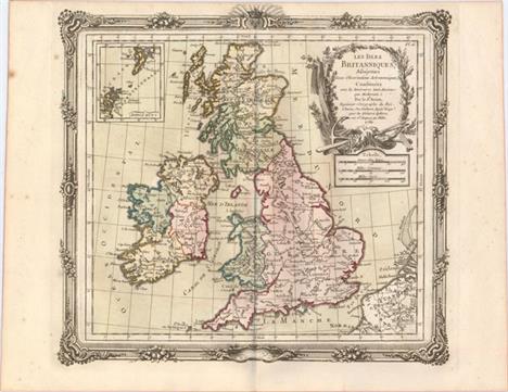
Les Isles Britanniques, Assujetties aux Observations Astronomiques A decorative and simply detailed map depicting topography with major place names noted. An inset of the Shetland and Orkney islands and three distance scales are also featured. The cartouche is decorated with garland and an anchor with two oars. The beautifully engraved picture-frame border was printed from a separate plate, and was designed in a rococo-style. A nice impression with original color, just a hint of color offsetting, and a few minor spots of foxing confined to the blank margins. 11"" W x 12.25"" H Brion de la Tour/Desnos, 1766
We found 63909 price guide item(s) matching your search
There are 63909 lots that match your search criteria. Subscribe now to get instant access to the full price guide service.
Click here to subscribe- List
- Grid
-
63909 item(s)/page
[On 2 Sheets] Carte de Moscovie Dressee par Guillaume de l`Isle de l`Academie Royale des Sciences a son Excellence Monseigneur Andre Artemonides de Matueof Matched pair of the northern and southern sheets of Delisle`s important map of the Russian Empire. Both sheets provide great detail of the towns, roads, forests and topography. The northern map is decorated with a nice title cartouche featuring a sleigh, coat of arms, animals and a hunter. The southern sheet includes Moscow and features three distance scales. Size given is approximate for each sheet. A very attractive example of this map in its original unjoined state. If joined the map would measure approximately 24.3 x 39"". Fine impressions with original color on watermarked paper and a soft crease adjacent to centerfold on northern sheet. There are some shadows that appear in the images that are caused by our scanner, and do not appear on the maps themselves. 19"" W x 24.3"" H Delisle/Covens & Mortier, 1730
St. Petersbourg Exceptional plan of the city centered on the fortress on the Neva River. The Neva is often called the Main Street of St. Petersburg, a reference to its importance to commerce and transportation. An extensive list at right identifies over 75 buildings including the palace, academy of science, gardens, mansions, and much more. The plan itself is remarkably detailed with individual streets and buildings shown. Decorative title cartouche with two distance scales below. Large compass rose with fleur-de-lys at lower left. This plan was originally made at the direction of the Academy of Sciences and Arts in 1753. Drawn by Dubuisson and engraved by Tardieu. Folding as issued with some soft folds and soil along centerfold. Glue remnants on verso along centerfold with a little show through. Small hole at fold intersection and an old repaired tear entering 1"" into legend at right. 17.1"" W x 28.4"" H Tardieu, Pierre Francois 1790
Tavola Esatta dell` Antico Latio e Nova Campagna di Roma Situata Sotto il Quinto Clima... This very attractive Italian map is centered on Rome and filled with details including villages and towns, farmland, forests, rivers, lakes and aqueducts. The map is surrounded by decorative elements including a coat of arms, scroll index of locations within the fortified city of Rome, a large divider containing three distance scales, and a title cartouche drawn on an animal pelt. Originally drawn by Innocenzo Mattaei circa 1666 and later engraved by Giorgio Widman and published by Giamcomo Rossi. A dark impression on watermarked paper with light soiling mostly in the blank margins and a worm track in right blank margin. 15.4"" W x 20.4"" H Rossi, Giamcomo Giovanni 1684
[Lot of 3] Egypten oder Misir [and] Karte des Arabischen Meerbusens oder des Rothen Meeres [and] Karte von dem Groessten Theil des Landes Jemen Imame, Kaukeban &. &.... This lot includes three large maps that cover the region from Egypt south to Somalia as well as the western Arabian peninsula showing portions of Yemen and Saudi Arabia. The first two maps of Africa show very good detail along the Nile River and the coastline of the Red Sea and display the location of emerald mines, ancient ruins, and caravan routes. The map of Arabia shows excellent inland detail with very dense hachuring and is filled with place names. Each map is adorned by a decorative title cartouche and several distance scales. The maps are based upon DAnville, Niebuhr, Irwin and Wussin. A. Egypten oder Misir, dated 1787, black & white (16.1 x 26.1""). Condition: There are a few small rust stains and a light damp stain along the upper left border. (B+)B. Karte des Arabischen Meerbusens oder des Rothen Meeres, dated 1787, hand color (18.7 x 26.5""). Condition: Scattered foxing. (B) C. Karte von dem Groessten Theil des Landes Jemen Imame, Kaukeban &. &. Nach Astronomischen Beobacht Ungen, und Reisemaassen, dated 1789, hand color (14.6 x 22.4""). Condition: A few minor spots in the image, else very good. (B+) Printed on heavy sheets with wide margins. See description for additional details. See description Schraembl, Franz Anton 1787-89
North America Detailed and finely engraved map that portrays an Independent Texas, with Mexico controlling Nueva California. The boundary between Canada and the United States is left unengraved, leaving the ownership of Oregon Territory (here labeled Columbia) unknown, which is unusual for a British map. Filled with well-developed topography, the map names numerous forts, trading posts, Indian tribes and locates L. Youla roughly near the Great Salt Lake with the American Fur Depot on its eastern shore. The R. Buenaventura extends to the Pacific from two branches, one originating from a large swamp in the Great Basin. The course of the Snake River is fairly accurate, but the Colorado River originates too far north and rushes to the Sea of Cortez in a straight line. Locates the 3 buttes in present-day Idaho -- important landmarks on the Oregon Trail. Lake Michigan retains its erroneous elongated shape. Distance scales outside of border give English Miles and Spanish Leagues. Engraved by J. & C. Walker and published by Chapman & Hall. Original outline color with just a hint of toning along edges of sheet. 15"" W x 12"" H SDUK Society for the Diffusion of Useful Knowledge, 1843
A Chart of Delaware Bay and River, from the Original by Mr. Fisher of Philadelphia. 1776. This Revolutionary War map was based on the chart Joshua Fisher made of Delaware Bay in 1756 and expanded upon in 1776. The Fisher map was the most important map of the bay and river in the eighteenth century. This map was derived from the 1776 edition, and was published with an article updating the British public on the war in the colonies. It shows the bay and beyond to Philadelphia and is filled with place names and the location of many hazards to navigation along the waterway. Locates Cape May, Turtle Gut Inlet, Cape James, Egg Island, Salem, and much more. Two distance scales and the direction rose with fleur-de-lis orients north to the right. Published in the July, 1779 issue of the Gentleman`s Magazine. Issued folding with faint offsetting. 7.2"" W x 9.2"" H Anon., 1779
-
63909 item(s)/page


![[On 2 Sheets] Carte de Moscovie Dressee par Guillaume de l`Isle de l`Academie Royale des Sciences a son Excellence Monseigne](http://lot-images.atgmedia.com/SR/36385/2916721/540-2014116144641_468x382.jpg)


![[Lot of 3] Egypten oder Misir [and] Karte des Arabischen Meerbusens oder des Rothen Meeres [and] Karte von dem Groessten The](http://lot-images.atgmedia.com/SR/36385/2916721/689-2014116145111_468x382.jpg)


