We found 63833 price guide item(s) matching your search
There are 63833 lots that match your search criteria. Subscribe now to get instant access to the full price guide service.
Click here to subscribe- List
- Grid
-
63833 item(s)/page


Lot 473
AN IRISH GEORGE IV TEA SERVICE AND A SIMILAR IRISH GEORGE III COFFEE POTof compressed circular shape with eagle spout or mask lip and richly chased with flowers, foliage and scales, on bearded mask and claw and ball feet, the service with caryatid handles, uniformly crested, coffee pot 23cm h, both Dublin, the service by Edward Power, 1824 and 25, the coffee pot by James Le Bass, 1819, 111ozs gross (4)++A particularly impressive Irish tea service with highly ornate decoration and in fine condition free from noticeable wear, no repairs, the feet on the sugar bowl slightly pushed in, the marks good, several pieces also struck for the retailer William Law. Long in the present local private vendor`s ownership


Lot 169
AN ANTIQUE ( PROBABLY MING ) CHINESE JADE CARVED FIGURE OF A FISH, THE MOTTLED CELADON AND BROWN PIECE WITH SCALES TO CENTRAL BODY AND FAN SHAPED TAIL WITH SUSPENSION HOLE TO MOUTH 6 CM`S X 3 CM`S. THIS ITEM WAS COLLECTED IN CHINA IN THE 1950`S BY AN ENGLISHMAN WHO WORKED UNDER LORD TREVELYAN BETWEEN 1952 - 1955.

Lot 47
Colin Middleton RHA RUA (1910-1983) Abstract with Toy Train Oil on board, 90 x 90cm (35.5 x 35.5") Signed with monogram Provenance: : Commissioned by Noel Campbell for Morelli's icecream parlour on the Promenade, Portstewart, Co. Derry, circa early 1970s. Literature: Dickon Hall, Colin Middleton: A Study, Joga Press, 2001, full page illustration, page 79 The variety and range of Colin Middleton's work is often commented on as its most notable aspect. Closer acquaintance with it reveals a unity that carries between styles and periods, both in technique and imagery. In each painting Middleton seems to be looking forward and back. Throughout the six decades that he painted, Middleton never left his initial training as a damask designer far behind, although at times this influence is almost submerged within paintings. Middleton's move to the north coast of Northern Ireland in the late 1950s marked a sharp break in his work; he found a landscape and, through this, a manner of painting that coalesced to express the point at which he found himself as a man and as an artist. During this period, Middleton seems to have been ready to re-introduce elements of his design background into his painting. This work demonstrates the complexity of design and visual inventiveness of which Middleton was capable. The series was painted for Morelli's café, famous as an ice cream parlour, on the seafront in Portstewart. This was arranged by Noel Campbell, a local architect who had been instrumental in a number of commissions for murals Middleton received in the late 1960s and 1970s. It was as rare then as it is now in Northern Ireland for an artist to be thus involved in architectural projects, so this panel has an historical resonance as well as occupying a very particular place within Middleton's career. The planned location, an ice cream parlour in a holiday town, might well have influenced their bright colours and energetic exuberance, as well as a choice of imagery likely to appeal to children. There are no known photographs of the panels installed in Morelli's, or any record of how the paintings were intended to be arranged. The diverse formats suggest that the location imposed certain demands upon the artist; the square format of two of the paintings was almost ubiquitous in Middleton's work at this time, but the elongated panels are unusual. The cross-fertilisation of ideas does suggest that they were closely hung to be viewed together. One panel (lot 27) dominates by virtue of the multitude of ideas with which it seems to vibrate. A simplified rendering of what appears to be a llama or alpaca is repeated on various scales, overlapping and creating a dizzying and confused sense of spatial recession. Small panels are placed within these with simplified and angular depictions of fish, a cockerel, a dog and a cat. The latter two recall the notation of Ancient Egypt and the dog is highly reminiscent of depictions of Anubis, the Egyptian jackal headed god (the alpaca might also be read as an image of a Pharaoh dog). In fact these panels carry some overtones of the Egyptian Book of the Dead. The alpaca shape is subtly repeated in the forms of the little house, the train and the girl, all reminders of the holiday spirit. A similar fish image was used by Middleton for the sign of a fish and chip shop in an early painting of Belfast, presumably here another reminder of summer in Portstewart. Middleton's vocabulary is derived from the shapes of objects in the visible world which over decades he has pared into the most visually effective and communicative signifier capable of carrying its meaning. These panels are more than just narrative, although they seem to contain so much. It is up to the viewer to find a personal interpretation or just to enjoy their stimulating presence. Dickon Hall Killinchy, Co. Down


Lot 4
Good quantity of plastic and metal wargaming miniatures and models, mostly WW2 or post-war era: consists of 50+ 1:72 scale plastic tank kits (mostly built and painted); 100+ 5mm scale modern warfare tanks and other vehicles; various aircraft WWI to modern; large quantity of infantry models in various scales; artillery pieces; etc. Overall G, many painted to a good standard.


Lot 737
Mixed lot of diecast models by various manufacturers in various scales: includes 2x Pixar `Cars` movie 2-model packs; 3x Teamsters Emergency Gift Set (Police, Ambulance, Fire Service); Cararama military Land Rover 3-pack; Hongwell and Oxford 1:76/OO scale cars; 5x Motorbikes, etc. Overall G/VG, boxed. (44).

Lot 216
5 Kitchen Scales, c. 1920 Art Nouveau and Art Deco, cast-iron faces, manufactured by: "Salter", "Wagner", "Lachmann" and "Alexanderwerk". - Add-on: 11-part weight set. 5 Küchenwaagen, um 1920 Jugendstil oder Art deco, gußeiserne Fronten, Hersteller: "Salter", "Wagner", "Lachmann" und "Alexanderwerk". - Dabei: 11-teiliger Gewichtesatz. Condition: (3/2) Starting Price: €80

Lot 292
English Pocket Sextant "Stanley", 1941 Box sextant, marked "Stanley, London", serial no. 4369, brass, silver scales, good condition. Englischer Taschen-Sextant "Stanley", 1941 Büchsen-Sextant, bezeichnet "Stanley, London", Serien-Nr. 4369, Messing, Silber-Skalen, guter Zustand. Condition: (3+/3+) Starting Price: €80

Lot 293
English Sextant "Berry & Son" Marked: "Berry & Son, West Hartlepool", bone scales, 6 filters, with dealer`s label in mahogany box. Englischer Sextant "Berry & Son" Gemarkt: "Berry & Son, West Hartlepool", Skalen aus Bein, 6 Filter, mit Händlerschild in Holzkasten. Condition: (3/-) Starting Price: €140

Lot 307
Artillery Compass, End of the 19th Century Germany or Austria, possibly by Voigtländer, lacquered brass, silvered compass scales, size 4 3/4 x 4 3/4 x 4 in. Artillerie-Kompaß, Ende 19. Jh. Deutschland oder Österreich, eventuell Voigtländer, zaponiertes Messing, Skalen im Kompaß versilbert, Maße 12 x 12 x 10 cm. Condition: (2-3/2) Starting Price: €180

Lot 325
English Theodolite "Cooke, Troughton & Simms", c. 1925 Serial no. 18213, polished brass, silver scales, 2 magnifying glasses, 2 bar levels, height 11 2/5 in., with accessories in mahogany box. Englischer Theodolit "Cooke, Troughton & Simms", um 1925 Serien-Nr. 18213, poliertes Messing, Silber-Skalen, 2 Ableselupen, 2 Stablibellen, Höhe 29 cm, mit Zubehör in Mahagonikasten. Condition: (3/3) Starting Price: €120

Lot 412
4 Pharmacy Scales, c. 1880 1) 2 herb scales, probably England, brass and iron. - 2) Hand scale, brass, length of the beam 8 3/4 in. - And: 3) Small German hand scales, brass with porcelain pans, length of the beam 4 3/4 in. 4 Apothekerwaagen, um 1880 1) 2 Kräuterwaagen, vermutlich England, Messing und Eisen. - 2) Handwaage, Messing, Balkenlänge 22 cm. - Und: 3) Kleine deutsche Handwaage, Messing mit Schalen aus Porzellan, bis 15 g, Balkenlänge 12 cm. Condition: (2-/-) Starting Price: €80

Lot 413
8 Small Scales 1) English pharmacy scale by "Provost & Crook, Eastborne", 18th century, oak case. - 2) English pharmacy scale, c. 1800, mahogany case. - 3) English diamond scale, nickel-silver scale, mahogany case, weight set not complete, c. 1850. - 4) 3 small pharmacy scales, brass with iron beams. - 5) Near Eastern scale in case, 19th century. - And: 6) Contemporary pharmacy scale in box. 8 kleine Waagen 1) Englische Apothekerwaage, 18. Jh., Eichenkasten, von "Provost & Crook, Eastborne". - 2) Englische Apothekerwaage, um 1800, Mahagonikasten. - 3) Englische Diamantenwaage, um 1850, Mahagonikasten, Waage aus Neusilber, Gewichtsatz unvollständig. - 4) 3 kleine Apothekerwaagen, Messing mit teilweise schön geschnittenem Eisen. - 5) Vorderasiatische Waage in Holzkasten, 19. Jh. - Und: 6) Moderne Apothekerwaage in Holzkasten. Condition: (3+/-) Starting Price: €100


Lot 111
Colonial New England and Canada (Partie Orientale de la Nouvelle France ou du Canada), Bellin, Paris, 1755. 21.3 x 17”. (HC) This is the final state of Bellin`s definitive map of eastern Canada and New England showing the mouth of the St. Lawrence, the length of the river, the Maritime provinces and French claims in the region. There are some very interesting details of the coastal towns, showing Havre de Baston for Boston Harbor, up the coast to Portsmouth in New Hampshire, Wells, York and Cape Elizabeth in Maine. There is considerable information shown on the extent of French exploration in the region. In this state, Bellin updated the plate with changes to the Saint Lawrence River, Lake Ontario and Cape Code. A large decorative cartouche incorporates two distance scales. Ref: Kershaw no.689; McCorkle no.745.1, Sellers and Van Ee no.273. Watermarked paper with a couple of minor spots, few miniscule worm holes at top right, and a light damp stain with a couple of tiny tears along centerfold at bottom. Remnants of paper tape on verso. (+B)

Lot 113
Colonial United States and Canada (Partie du Nord de l`Amerique Septentrionale pour Servir a l`Histoire Philosophique et Politique…), Bonne, Raynal`s Histoire Philosphique et Politique, Geneva, ca. 1774. 9.3 x 12.6”. (HC) This attractive map of the eastern part of North America shows the British colonies confined along the eastern seaboard with French Louisianne and Canada taking up the interior. In the upper left is a series of rivers and lakes purportedly connecting Hudson Bay with "la Mer de l`Ouest" (Sea of the West). Features include the notation of the Natchitoches tribe in Louisiana Territory, along with numerous additional native tribes. Three distance scales and a fine shield-style cartouche embellish the composition. No engraver`s imprint on this edition. Ref: McCorkle no.774.1. Watermarked paper with some minor extraneous creasing and a few small spots. (+B)

Lot 173
Southeast United States (Carte de la Partie Sud des Etats Unis de l`Amerique Septentrionale), Bonne, Paris, ca. 1778. 12.5 x 8.3”. (HC) Attractive and concise copper-engraved map that covers the states of Virginia, North and South Carolina, and Georgia in the new United States. All settlement is confined east of the Appalachians with les Cherokees the only note in the otherwise blank region west of the mountains. There are four distance scales located on the left side of the map. Engraved by Andre. Ref: Sellers & Van Ee no.1406. Faint offsetting. (A)
![Florida, Georgia ([Lot of 2] Florida. Nach den besten Quellen bearbeitet [and] Neueste Karte von Georgia mit seinen Strassen,](http://lot-images.atgmedia.com/SR/36385/2862480/176-2012510161833_468x382.jpg)
Lot 176
Florida, Georgia ([Lot of 2] Florida. Nach den besten Quellen bearbeitet [and] Neueste Karte von Georgia mit seinen Strassen, Eisenbahnen und Entsernungen), Meyer, Hand Atlas, 1845. 11.5 x 14.5”. (HC) A. Florida. Nach den besten Quellen bearbeitet. This is an interesting map of the state of Florida based on the important Mitchell series showing towns, forts, roads, canals, major rivers and lakes. There are references to forts, battlefields, and routes used by the Army during the Seminole War. There are also three inset maps detailing Pensacola, Tallahassee, and St. Augustine. Water routes from St. Augustine and Pensacola to various ports are described along the upper and lower margins. B. Neueste Karte von Georgia mit seimen Strassen, Eisenbahnen und Entsernungen. This is the German edition of the Tanner/Mitchell Georgia map from the New Universal Atlas, with a German title but using English place names. Along the bottom of the map are the steamboat routes from Savannah to Augusta and Charleston (here spelled Carleston). The map shows early county development along with gold mines, canals, trails, roads and railroads. It has a remarkable twelve distance scales. Florida has a few faint spots with light toning along sheet edges Georgia is lightly toned with a few edge tears confined to the blank margins that are closed on verso with archival tape. (+B)

Lot 399
Central South America, Paraguay (Paraguay, o Prov. de Rio de la Plata cum Regionibus Adiacentibus Tucuman et Sta. Cruz de la Sierra), Blaeu, Amsterdam, ca. 1640. 19 x 14.8”. (HC) Superb map of the region including the Paraguay River basin and the Peru-Chilean coast with Lake Titicaca. The Rio de la Plata is boldly shown with many large islands in the broad river. The mythical Lago de los Xarayes is featured on the map, which was believed to connect the Rio de la Plata and Amazon River systems. Several towns are named including R. Ianeiro, S. Paulo, Buenos Ayres, Corduba, Medoca, Arica, Potosi and Cusco. A large decorative title cartouche incorporates the distance scales, while a smaller cartouche features an armillary sphere. A fine, large compass rose with fleur-de-lys also adorns the sheet. Dutch text on verso. Old color and wide margins with light damp stains that just enter map border at bottom & a couple tiny tears in wide original margins, none affecting the map. (+B)

Lot 456
Bedford, England (Bedford Shire), Morden, Britannia, London, ca. 1722. 15.8 x 12.5”. (BW) This county map of Bedfordshire shows the early road system with the city of Bedford located at center along the Great Ouse river. The map is divided into Hundreds and displays interesting detail including the locations of buildings, rivers, bridges and parks. There is an attractive drape-style cartouche and three distance scales. Sold by Abel Swale, Awnsham & John Churchil. Morden was one of the first English cartographers to show longitudes measured from the meridian of St. Paul`s Cathedral (shown in degrees at the bottom of the map) and time in minutes measure locally from the sun (shown at the top in Roman numerals). The roads on his maps are based on Ogilby`s earlier survey. The Britannia was first published by historian William Camden (1551-1623) in 1586. After the publication of the final edition of Britannia in 1637, the work was not published again until 1695 when Gibson revised and translated the text from the original Latin and included fifty maps, mostly of the English counties, prepared by Robert Morden, replacing the outdated maps of Christopher Saxton. This map is from the subsequent edition of 1722. Watermarked paper with some light printer`s ink residue, else very good. (+B)

Lot 457
Huntington, England (Huntington Shire), Morden, Britannia, London, ca. 1722. 17 x 14”. (BW) This county map of Huntingtonshire shows the early road system. The map is divided into Hundreds and displays interesting detail including the locations of buildings, rivers, bridges and parks. The city of Cambridge in Cambridgeshire is located at right. There is an attractive drape-style cartouche and three distance scales. Sold by Abel Swale, Awnsham & John Churchil. Morden was one of the first English cartographers to show longitudes measured from the meridian of St. Paul`s Cathedral (shown in degrees at the bottom of the map) and time in minutes measure locally from the sun (shown at the top in Roman numerals). The roads on his maps are based on Ogilby`s earlier survey. The Britannia was first published by historian William Camden (1551-1623) in 1586. After the publication of the final edition of Britannia in 1637, the work was not published again until 1695 when Gibson revised and translated the text from the original Latin and included fifty maps, mostly of the English counties, prepared by Robert Morden, replacing the outdated maps of Christopher Saxton. This map is from the subsequent edition of 1722. There is a hint of offsetting in the image and faint toning along centerfold. Watermarked paper. (+B)
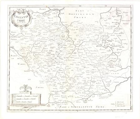
Lot 458
Leicester, England (Leicester Shire), Morden, Britannia, London, ca. 1722. 17 x 14”. (BW) This county map of Leicester shows the early road system. The town of Leicester is located near the center of the map along the Soar River. The map is divided into Hundreds and displays interesting detail including the locations of buildings, rivers, bridges and parks. There is a decorative title cartouche and three distance scales. Sold by Abel Swale, Awnsham & John Churchil. Morden was one of the first English cartographers to show longitudes measured from the meridian of St. Paul`s Cathedral (shown in degrees at the bottom of the map) and time in minutes measure locally from the sun (shown at the top in Roman numerals). The roads on his maps are based on Ogilby`s earlier survey. The Britannia was first published by historian William Camden (1551-1623) in 1586. After the publication of the final edition of Britannia in 1637, the work was not published again until 1695 when Gibson revised and translated the text from the original Latin and included fifty maps, mostly of the English counties, prepared by Robert Morden, replacing the outdated maps of Christopher Saxton. This map is from the subsequent edition of 1722. There is some light offsetting, else very good. Watermarked paper. (+B)

Lot 459
Northampton, England (Northampton Shire), Morden, Britannia, London, ca. 1722. 16 x 14”. (BW) This county map of Northamptonshire shows the early road system, with Northampton located at the center of the sheet. The map is divided into Hundreds and displays interesting detail including the locations of buildings, rivers, bridges and parks. There is an attractive drape-style cartouche and three distance scales. North is oriented to the right. Sold by Abel Swale, Awnsham & John Churchil. Morden was one of the first English cartographers to show longitudes measured from the meridian of St. Paul`s Cathedral (shown in degrees at the bottom of the map) and time in minutes measure locally from the sun (shown at the top in Roman numerals). The roads on his maps are based on Ogilby`s earlier survey. The Britannia was first published by historian William Camden (1551-1623) in 1586. After the publication of the final edition of Britannia in 1637, the work was not published again until 1695 when Gibson revised and translated the text from the original Latin and included fifty maps, mostly of the English counties, prepared by Robert Morden, replacing the outdated maps of Christopher Saxton. This map is from the subsequent edition of 1722. There is a hint of toning along the centerfold, with a portion of the centerfold reinforced with old paper. Watermarked paper. (+B)

Lot 460
Cheshire, England (The County Palatine of Chester), Morden, Britannia, London, ca. 1722. 16 x 14”. (BW) This county map of Cheshire shows the early road system with the town of Chester located on the left side of the sheet next to the River Dee. The map is divided into Hundreds and displays interesting detail including the locations of buildings, rivers, bridges and parks. There is a decorative title cartouche and three distance scales. Sold by Abel Swale, Awnsham & John Churchil. Morden was one of the first English cartographers to show longitudes measured from the meridian of St. Paul`s Cathedral (shown in degrees at the bottom of the map) and time in minutes measure locally from the sun (shown at the top in Roman numerals). The roads on his maps are based on Ogilby`s earlier survey. The Britannia was first published by historian William Camden (1551-1623) in 1586. After the publication of the final edition of Britannia in 1637, the work was not published again until 1695 when Gibson revised and translated the text from the original Latin and included fifty maps, mostly of the English counties, prepared by Robert Morden, replacing the outdated maps of Christopher Saxton. This map is from the subsequent edition of 1722. There is light toning along the centerfold, faint offsetting and a few tiny spots in the image. There is one minute pinhole at left and a printer`s crease along the lower neatline. Watermarked paper. (+B)

Lot 461
Wilts, England (Wilt Shire), Morden, Britannia, London, ca. 1722. 16.3 x 13.5”. (BW) This county map of Wiltshire shows the early road system. The map is divided into Hundreds and displays interesting detail including the locations of buildings, rivers, bridges parks and mountains in profile. There is an attractive drape-style cartouche and three distance scales. Sold by Abel Swale, Awnsham & John Churchil. Morden was one of the first English cartographers to show longitudes measured from the meridian of St. Paul`s Cathedral (shown in degrees at the bottom of the map) and time in minutes measure locally from the sun (shown at the top in Roman numerals). The roads on his maps are based on Ogilby`s earlier survey. The Britannia was first published by historian William Camden (1551-1623) in 1586. After the publication of the final edition of Britannia in 1637, the work was not published again until 1695 when Gibson revised and translated the text from the original Latin and included fifty maps, mostly of the English counties, prepared by Robert Morden, replacing the outdated maps of Christopher Saxton. This map is from the subsequent edition of 1722. Watermarked paper with some offsetting, light printer`s ink residue, and a 0.5" hole near the centerfold repaired with old paper on verso, with minor loss of image. (B)

Lot 462
Stafford, England (Stafford Shire), Morden, Britannia, London, ca. 1722. 14.5 x 17”. (BW) This county map of Staffordshire shows the early road system, with the town of Stafford located at the center of the sheet. The map displays interesting detail including the locations of buildings, rivers, bridges and parks. There is a decorative title cartouche and three distance scales. Engraved by Sutton Nicholls and sold by Abel Swale, Awnsham & John Churchil. Morden was one of the first English cartographers to show longitudes measured from the meridian of St. Paul`s Cathedral (shown in degrees at the bottom of the map) and time in minutes measure locally from the sun (shown at the top in Roman numerals). The roads on his maps are based on Ogilby`s earlier survey. The Britannia was first published by historian William Camden (1551-1623) in 1586. After the publication of the final edition of Britannia in 1637, the work was not published again until 1695 when Gibson revised and translated the text from the original Latin and included fifty maps, mostly of the English counties, prepared by Robert Morden, replacing the outdated maps of Christopher Saxton. This map is from the subsequent edition of 1722. There is some faint offsetting, a hint of toning along the fold, and a printer`s crease above the centerfold. Watermarked paper. (+B)

Lot 463
Lincoln, England (Lincoln Shire), Morden, Britannia, London, ca. 1722. 16.5 x 14.3”. (BW) This county map of Lincolnshire shows the early road system, with the town of Lincoln located near the center of the sheet. The map displays interesting detail including the locations of buildings, rivers, bridges and parks. There is a decorative title cartouche and three distance scales. Sold by Abel Swale, Awnsham & John Churchil. Morden was one of the first English cartographers to show longitudes measured from the meridian of St. Paul`s Cathedral (shown in degrees at the bottom of the map) and time in minutes measure locally from the sun (shown at the top in Roman numerals). The roads on his maps are based on Ogilby`s earlier survey. The Britannia was first published by historian William Camden (1551-1623) in 1586. After the publication of the final edition of Britannia in 1637, the work was not published again until 1695 when Gibson revised and translated the text from the original Latin and included fifty maps, mostly of the English counties, prepared by Robert Morden, replacing the outdated maps of Christopher Saxton. This map is from the subsequent edition of 1722. There are a few minor spots in the image and a small printer`s crease in the upper portion of the image near the neatline. Watermarked paper. (+B)

Lot 464
Berkshire, England (Bark Shire), Morden, Britannia, London, ca. 1722. 16.5 x 14”. (BW) This county map of Berkshire shows the early road system and Windsor Castle at lower right. The map is divided into Hundreds and displays interesting detail including the locations of buildings, rivers, bridges and parks. There is an attractive drape-style cartouche and three distance scales. Sold by Abel Swale, Awnsham & John Churchil. Morden was one of the first English cartographers to show longitudes measured from the meridian of St. Paul`s Cathedral (shown in degrees at the bottom of the map) and time in minutes measure locally from the sun (shown at the top in Roman numerals). The roads on his maps are based on Ogilby`s earlier survey. The Britannia was first published by historian William Camden (1551-1623) in 1586. After the publication of the final edition of Britannia in 1637, the work was not published again until 1695 when Gibson revised and translated the text from the original Latin and included fifty maps, mostly of the English counties, prepared by Robert Morden, replacing the outdated maps of Christopher Saxton. This map is from the subsequent edition of 1722. There is some light offsetting and printer`s ink residue in the image, else very good. A tiny tear in bottom blank margin has been closed on verso with old paper. Watermarked paper. (+B)

Lot 465
Nottingham, England (Nottingham Shire), Morden, Britannia, London, ca. 1722. 16 x 14”. (BW) This county map of Nottinghamshire shows the early road system, with the town of Nottingham located in the lower portion of the sheet. The map displays interesting detail including the locations of buildings, rivers, bridges and parks. There is a decorative title cartouche and three distance scales. Sold by Abel Swale, Awnsham & John Churchil. Morden was one of the first English cartographers to show longitudes measured from the meridian of St. Paul`s Cathedral (shown in degrees at the bottom of the map) and time in minutes measure locally from the sun (shown at the top in Roman numerals). The roads on his maps are based on Ogilby`s earlier survey. The Britannia was first published by historian William Camden (1551-1623) in 1586. After the publication of the final edition of Britannia in 1637, the work was not published again until 1695 when Gibson revised and translated the text from the original Latin and included fifty maps, mostly of the English counties, prepared by Robert Morden, replacing the outdated maps of Christopher Saxton. This map is from the subsequent edition of 1722. Watermarked paper with some light offsetting and a few small spots in the image, else very good. (+B)

Lot 466
England & Wales (England), Morden, Camden`s Britannia, London, ca. 1695. 16.5 x 14.3”. (HC) Robert Morden was commissioned by Dr. Edmund Gibson to prepare new maps for Camden`s Britannia, which was last published early in the century with maps by Hole and Kip. However, no additional survey work was done by Morden, so this map draws largely upon the work of Saxton and Speed. The map itself is relatively straightforward and depicts counties, cities and roads. The title is enclosed in an elegant cartouche along with three distance scales. Ref: Shirley (BI to 1750) Morden 10. There is a 0.25" loss near Gloucester that has been covered with old paper on verso and light toning in blank margins. (+B)
-
63833 item(s)/page