We found 12130 price guide item(s) matching your search
There are 12130 lots that match your search criteria. Subscribe now to get instant access to the full price guide service.
Click here to subscribe- List
- Grid
-
12130 item(s)/page

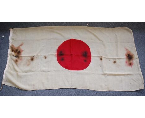
Lot 282
A WW II period Japanese flag of cotton construction with central red "meatball" disc, 89 x 175cm, together with a Union Flag, 89 x 136cm, a Blue Ensign, 86 x 150cm, an Australian Red Ensign, 39 x 76cm, a Panama flag, 85 x 175cm, a string of bunting and a kit bag marked 14485442 E. Collins 63 Coy. Records show that 14485442 Private E.J. Collins served in the Royal Army Ordnance Corps.
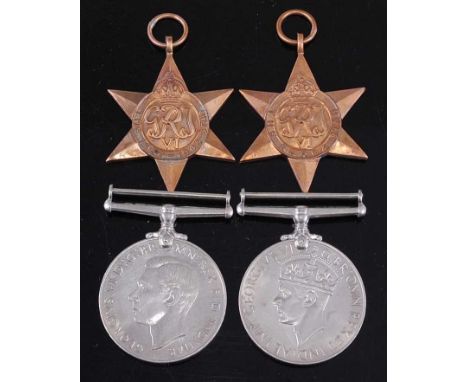
Lot 68
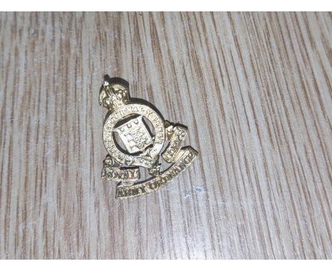
A group of four WW II medals, to include 1939-1945 Star, Burma Star, Defence and War in OHMS box (no address), together with a Soldier's Service and Pay Book, naming 10875836 Kenneth Alexander McColl, an Observers wing badge a Royal Army Ordnance Corps cap badge and one other collar badge. (7)

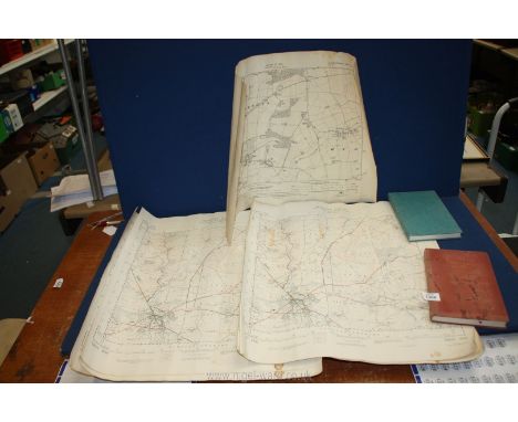
Lot 23
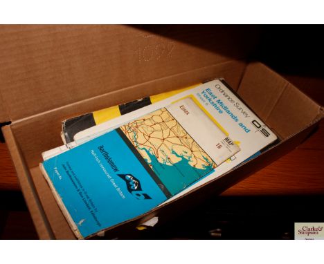
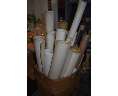
COLLECTION OF MAPS,including early 20th century Ordnance Survey, facsimile antiquarian maps, modern geological maps, two framed relief maps, a large world map by Aprim Graphic, France, approximately 2m x 4m, and four publications on maps including Maps of Yorkshire (Whitaker H. Ed.) and re-issue of Bartholemew's Motorist's Road Maps pub. Sandpiper Books 2013Deacon's Chart poor, torn, browned and heavily worn
Lot 265
NO RESERVE London.- Whitbread's Reduced Ordnance Map of London, large folding map, some tears to foldlines, one large tear with tape repair, Index detached and loosely inserted, light browning, original cloth, printed paper label to upper cover, a little rubbed, [1880] § Extracts from the Court Rolls of the Manor of Wimbledon, scattered spotting, cracked hinges, previous owner's ink signature, original cloth, a little rubbed, 1866 § Geographers' A to Z Atlas of London, maps, original paper wrappers, faded, light spotting, [c.1947] § D'Elboux (R. H.) and Winifride Ward. The Registers of St. Dunstan in the Eaast London, scattered spotting, original cloth, slight bumping to corners and extremities, The Harleian Society, 1958; and others London, v.s. (c.25)
Lot 164
A Collection of Approximately Thirty British Cap and Glengarry Badges, including First World War Royal Ordnance Factories, 25th County of London Cyclists, RAF, Royal Marines, cloth insignia etc; a Small Quantity of Militaria, including a postcard album containing approximately two hundred postcards, mainly related to the First World War, including some real photographic, mainly colour printed by Tucks, Valentines etc, three framed chromolithographic cut-outs, a book - The Worcestershire Regiment by Richard Gale, an ARP handbook and whistle etc
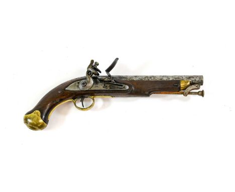
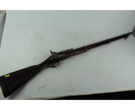
Lot 381
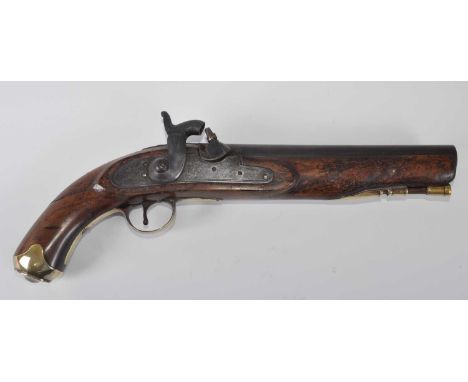
A British New Land Pattern Flintlock Service Pistol, the 22.5cm round steel barrel with Board of Ordnance marks, the lock plate faintly marked with crown over GR and crowned arrow, the walnut stock with brass fore-end tip, trigger guard, butt cap and side plate engraved P+A+PHILLIPS May 1825, with swivel steel ramrod, 40cmAction works, holds at full and half cock, rust pitting to barrel, hammer and with cleaned off lock plate. The ramrod is rusty and needs freeing with oil. The stock with a repair under the ramrod and to the grip, with bruising and signs of cleaning.
Lot 91
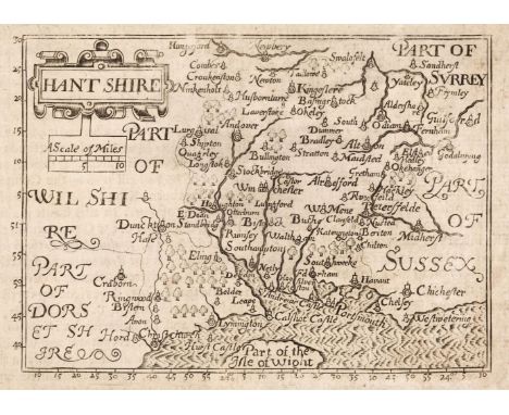
Dorset & Hampshire. A collection of 21 maps, 17th - 19th century, engraved and lithographic county maps and town plans including Bill (John). Hant Shire, circa 1626, uncoloured engraved map, torn with loss to margins but not affecting the printed image, dust-soiled and stained, 90 x 125 mm, English text on verso, together with Blome (Richard). A Mapp of Hantshire circa 1673, hand-coloured engraved map. toned overall, slight mount staining, margins professionally restored, 300 x 260 mm, with Moll (Herman). Hamp Shire, circa 1724, hand-coloured engraved map with the vertical margins decorated with antiquities, 195 x 310 mm, with another copy similar, plus Morden (Robert). Dorsetshire [and] Hampshire [1695 or later], two hand-coloured engraved maps, each approximately 365 x 420 mm, with others similar including examples by or after Moule, Ordnance Survey, J & C Walker, Taylor, Cary, Harrison, Bacon and Smith, various sizes and condition, together with 3 uncoloured engraved topographical views by S. & N. Buck from their 'Antiquities' series, each approximately 195 x 370 mmQTY: (24)
Lot 100
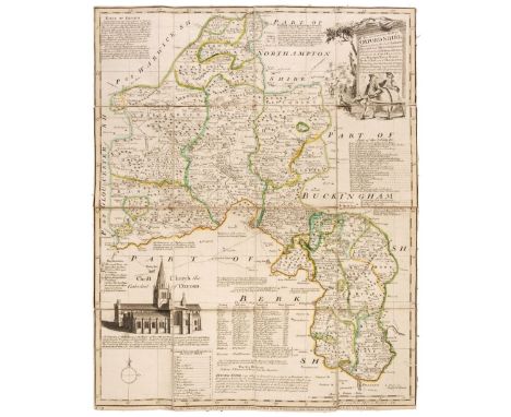
Folding Maps. A mixed collection of approximately 60 maps, 18th - 20th century, including Stanford (Edward, publisher). Bartholomew's "Half-Inch to Mile" Map of England & Wales, 37 parts (complete), circa 1905, 37 colour lithographic maps, sectionalised and laid on linen, each with publisher's printed paper endpapers, one map with frayed and torn endpapers, each approximately 520 x 640 mm, together with Bowen (Emanuel). An Accurate Map of Oxfordshire Drawn from the Best Authorities, Divided into Hundreds and Illustrated with Historical Extracts..., printed for Bakewell & Parker, J. Bowles & Son, T. Bowles, T. Kitchin, R. Sayer and J. Ryal, circa 1765, engraved map with contemporary outline colouring, sectionalised and laid on linen, 505 x 400 mm, contained in a contemporary marbled card slipcase with a manuscript title to the upper cover, slipcase faded and worn, with Hasted (Edward). A Compleat Map of the County of Kent taken from a late actual survey and accurately corrected to the present year, 1801, engraved map with contemporary outline colouring, sectionalised and laid on linen, slight staining, old rust holes to each corner (possibly caused by drawing pins), near-contemporary manuscript ownership signature (Captain Packe First Guards) to verso, 495 x 695 mm, plus Bowen (Emanuel). An Accurate Map of Northampton Shire Divided into its Hundreds...., J. Tinney, 1753, engraved map with contemporary outline colouring, some staining and dust soiling, 705 x 540 mm, contained in a contemporary marbled card slipcase, with publisher's printed title label to the upper cover, slipcase worn and frayed, and Cary (John). Cary's Reduction of his large Map of England and Wales, with part of Scotland..., 1832, engraved map with contemporary outline colouring, sectionalised and laid on linen, some staining and dust soiling, some damp staining to the verso, marbled endpapers, 755 x 625 mm, contained in a contemporary green marbled slipcase with a publisher's circular title label to the upper cover, slipcase frayed and worn, with another 23 folding British and foreign maps, including examples by or after Ordnance Survey, Hall, Macaulay, Brown & Sons, Bartholomew, Stanford, Waddington & Son, Burrows and Lizars, various sizes and condition, with Tallis (John & Co.). Ten pictorial maps (West India Islands, North America, Nova Scotia and Newfoundland, Falkland Islands & Patagonia, South America, East Canada and New Brunswick, West Canada (2 copies), Central America, New South Wales) circa 1860, engraved maps with contemporary outline colouring, each map decorated with uncoloured vignettes, some staining and spotting and short splits along the central fold, each approximately 265 x 330 mm, and Sutherland (T. & Havell D.). Fifteen engravings after C. G. Shutz, originally published in 'Views on the Rhine' R. Ackermann, 1819, aquatints with contemporary hand-colouring (Mentz, Cologne, The Castle of Furstenberg, Bacharach, Pfalz Castle and the Town of Laub, Thurnberg, Liebenstein, Braubach, Bornhofen, Boppard, Engers and Sayn, Andernach and Neuwied, Hammerstein, The Castles of Drachenfels & Rolandseck [and] Bodesberg and the Severn Hills, some spotting, staining and dust soiling, each approximately 240 x 290 mmQTY: (approx. 86 )
Lot 103
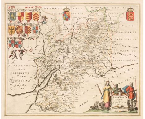
Gloucestershire. Blaeu (Johannes), Glocestria Ducatus vulgo Glocestershire, Amsterdam, circa 1648, engraved map with contemporary outline colouring, large decorative cartouche and mileage scale, 410 x 495 mm, Latin text on verso, together with Blome (Richard). Gloucestershire. T. Taylor, circa 1717, engraved map with contemporary outline colouring, torn with slight loss along the central fold, tipped on to later thin card, 255 x 195 mm, with Ramble (Reuben). Glocestersh. [1821 - 1844], hand-coloured engraved map surrounded by lithographic vignettes, 195 x 160 mm, mounted, plus Van der Aa (Pieter). Glocester Glovernia Claudio Cestria, Leiden, circa 1730, uncoloured engraved city plan, set within an engraved 'picture frame' border alongside three topographical views, overall size 235 x 410 mm, and Whittaker (G. & W. B. publishers). Glocestersh. 1821, map with contemporary outline colouring, engraved by Neele & Son, 180 x 145 mm, with another 9 regional & historical maps and town and city plans, including examples by or after Dawson, Ordnance Survey, Tovey/Griffith, Wall, Taylor, Miller and Lysons, various sizes and condition, together with 9 topographical engravings of Gloucestershire, including examples by S & N Buck, Wickes, and Kirk, various sizes, good condition QTY: (23)
Lot 124
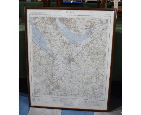
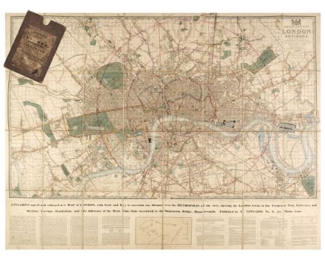
London. Laurie (Richard Holmes, publisher), Laurie's New Plan of London and its Environs, with an Improved Scale for Ascertaining Distances..., by John Lingard No. 3 Maria Lane, London, being an Original Survey by John Outhett, with all the recent Improvements, 1846, engraved map with contemporary outline colouring, sectionalised and laid on linen, new title pasted over old printing, additional title - "Lingard's Superb and Enlarged New Map of London with Scale and Key to ascertain any Distance over the Metropolis...," and explanatory text below the map, very slight staining, cloth endpapers, 820 x 1090 mm, contained in a contemporary cloth slipcase with a printed label to upper cover, worn and a little bumped, together with three mid-19th century Ordnance Survey maps of Staffordshire, Nottinghamshire and South Yorkshire, two with contemporary outline colouring, all contained in contemporary morocco slipcases and bindings, various sizes, good conditionQTY: (4)NOTE:The first described item. James Howgego. Printed Maps of London, no. 361, state 7.
Lot 180
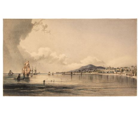
Jamaica. Kidd (Joseph Bartholomew). Morant Bay, circa 1837, hand-coloured lithograph. trimmed to the image with the title tipped onto the verso, 250 x 435 mm, together with Duperly (Adolphe). A View of the Ordnance Yard (taken from the Wharf) & Methodist Chapel, circa 1840, two uncoloured tinted lithographs originally published in 'Daguerian Excursions in Jamaica', the Methodist Chapel with thread margins and the title excised and tipped onto the verso, mount stained, laid on later card, 170 x 245 mm, 'A View of the Ordnance Yard', trimmed to image but retaining the title, mount stained, 195 x 250 mmQTY: (3)NOTE:Between 1835 and 1843, Kidd visited Jamaica three times. In 1837, he published Part I of his West Indian Scenery: Illustrations of Jamaica, in a series of views comprising the Principal Towns, Public Buildings, Estates and most picturesque scenery of the Island...., The success of the five plates in this series, led to a total of fifty drawings and paintings over the following four years.
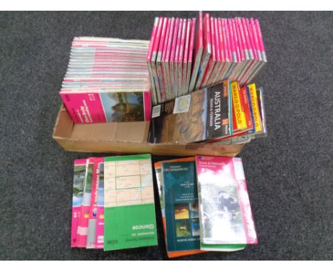
Lot 17
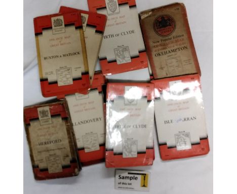
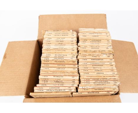
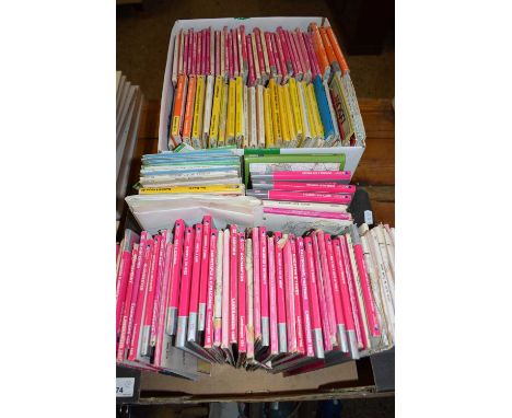
65+ Ordnance Survey Maps. One Inch Editions sheets mainly England & Wales issues published in the 1940s. Including; Preston, Snowdon, Norwich, Cambridge & Ely, LLandovery, Aldershot, Chatham & Maidstone, East Kent, Okehampton, The Solent, Hastings, Land's End, etc. Mainly QGC-VGC, some wear to most. £40-60
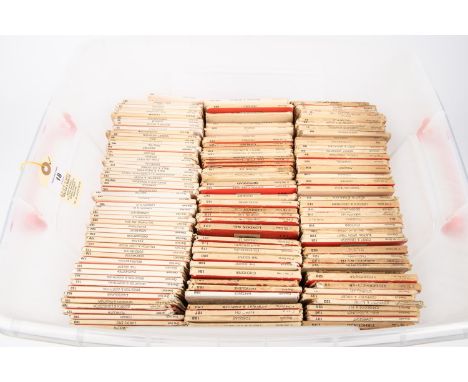
Lot 18
150+ Ordnance Survey Maps. One Inch Editions sheets mainly England & Wales issues published in the 1950s and 1960s. Including; Ayr, Selkirk, Jeburgh, Bala & Welshpool, Fishguard & Pembroke, The Solent, Land's End, Truro & Falmouth, Hereford, Swansea, London SW, London, Torquay, Glasgow, Market Weighton, Chester, Aberystwyth, etc. Mainly QGC-VGC, some wear to most. £50-70
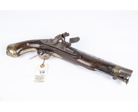
Lot 318
A .65" New Land Pattern flintlock holster pistol, 15" overall, barrel 9" with worn ordnance proofs; the lock bearing crown over "GR" and "TOWER"; fullstocked with regulation pattern brass mounts and swivel ramrod. GWO & Generally GC (worn overall, some pitting, barrel cleaned, fore end chipped). £250-300
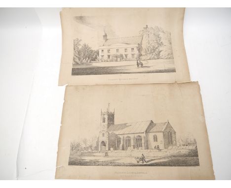
Lot 4054A
A pair of local interest 19th Century lithographs of Palgrave Rectory, and Palgrave Church, both W. Browne lith, Norwich, both approx 39 x 56cm, both with closed tears and chips; together with four early 20th Century Suffolk Ordnance Survey map sheets including Eye, Aspall, Southolt etc (6)
Lot 355
Collection of ephemera, to include Little Langford plan, Ordnance Survey of Wiltshire, 1901 map of South America, 1935 letter to the Owner of Ashley Cottage asking to be the agents to sell the home, early 20th Century Christmas cards, an Oriental style print, Victorian magazine, an 1863 copy of the Telegraph, 1806 Copy of the Times, Vamping Chart, Wightman's etc, (qty)
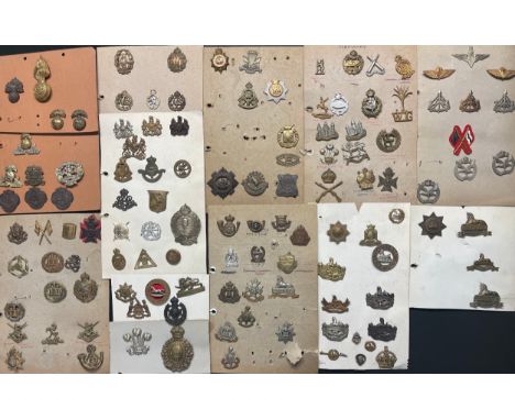
Lot 2194
A collection of approx. 100 British & Commonwealth Cap badges plus some collar dogs and WW1 War Service badges to include: Northumberland Fusiliers, Lancashire Fusiliers, South Lancs Regt, WAAC, Queen Mary's AAC, ATS, WRAC, General Service Corps inc plastic, RAOC, 2nd battl Duke of Wellington's, East Surrys, KRRC, PTI, Northants, Kings Own Malta Regt, Essex Regt, Coventry Ordnance Works Special War Service, East Yorks, West Yorks, Kings Own, CCG, RTR, Welsh Guards, Lincolnshire Regt, Gloucestershire Regt, etc.
Lot 1189
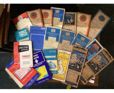
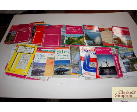
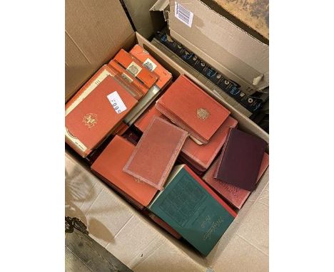
FIVE BOXES OF BOOKS, ROAD ATLASES, ORDNANCE SURVEY MAPS AND TOPOGRAPHICAL EPHEMERA ETC, books' subjects include topographical, fishing, travel, autobiographies, social history etc, maps include Ireland North, South, East and West, Anglesey, Derby and Burton Upon Trent, Nuneaton & Tamworth, etc, road atlases include London, Leicestershire and Rutland, Cheshire, Derbyshire, Notts, Northamptonshire, Birmingham etc
Lot 225
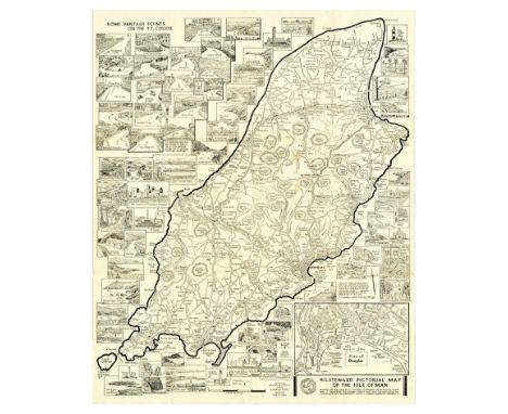
Original vintage motor racing poster H.G. Steward Large Scale Pictorial Map of the Isle of Man showing T.T. Course & Vantage Points, roads, railways, villages and street plan of Douglas including 70 illustrations of some of the many places of interest throughout the island. Designed and published by H.G. Steward. Based upon the Ordnance Survey Map with the sanction of the Controller of H.M. Stationery Office. Printed by Bridson & Horrox Limited. Good condition, folds as issued, creasing, staining, folds down into booklet. Country of issue: UK, designer: HG Steward, size (cm): 57x45, year of printing: 1960s.
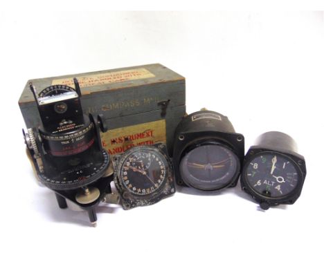
Lot 652
THREE BRITISH MILITARY AIRCRAFT INSTRUMENTS comprising an S. Smith & Sons, London clock, Mk IIIB, No.830/39, Ref. No.6A/839, the part luminous Arabic numeral 24-hour circular dial with subsidiary Time of Trip dial, the case impressed to the reverse '[crown] A.M.', and '830'; a Kelvin & Hughes Altimeter Mk 14A, Ref. 6A/3380, serial no.3769/59, the case marked to the reverse with an ordnance arrowhead; and an Artificial Horizon Mk II, Ref. No. 6A/711, serial no.5289/36, the case with 'AM' mark; together with an Astro Compass Mk II, Ref. 6A/11740, in original grey-painted fitted case, (4).

Lot 60
Assorted volumes to include:-"Hertfordshire Illustrated Review", vol 1, 1893, marbled ep, half-calf over boardsKnight, C & Smith P "The History of England", A Fullarton 1879, marbled ep, marbled edges, half-leather with gilt titles and assorted volumes on gardens, topography, Observer books, collecting, etc and an Ordnance Survey map on linen 'Ruislip Parish' (1 box) Condition ReportPlease see additional imageMap folds into covers
Lot 217
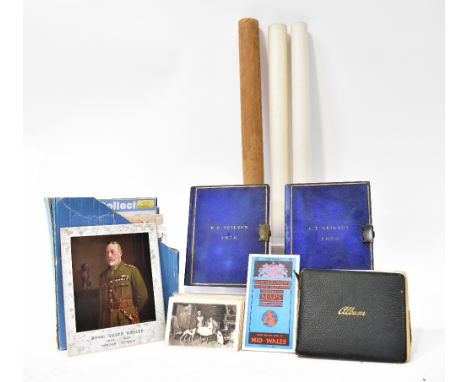
A quantity of vintage ephemera from the collection of a family, to include two locked diaries from 1876, with blue covers stamped A P Neilson and R B Neilson, various ordnance surveys of Great Britain and vintage Girl Guide brochures, needlework and sewing patterns, blank estate books, a Lloyds Shipping Register book (1962-1963) Vol I, in a brown paper cover, a scrapbook without cover with various vintage cartoons pasted in, the majority of which by Matt, dating from 1913 to 1917, various blank printed menu booklets with monogram engravings, a visitors' sketchbook depicting various watercolours, poems, sketches and cartoons, together with a pair of watercolours by R B Wright, each depicting a castle looking over a lake, both signed and dated 1911, 20 x 54cm, one framed and glazed, the other out of frame and without glass (af).
Lot 743
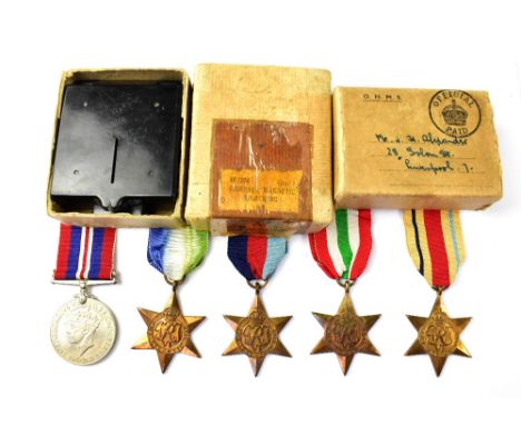
Five WWII medals to include the Campaign Medal, the Africa Star, the Italy Star, the Atlantic Star and a War Medal, with Admiralty certificates, in original box addressed to Mr J H Alexander, also a T. G. Co Ltd Bakelite 'Compass. Magnetic Marching, Mark.1.' folding compass, stamped with the Board of Ordnance broad arrow and further inscribed with serial no. B82904, in original box.

-
12130 item(s)/page