We found 12130 price guide item(s) matching your search
There are 12130 lots that match your search criteria. Subscribe now to get instant access to the full price guide service.
Click here to subscribe- List
- Grid
-
12130 item(s)/page


Lot 101
LEWIS (SAMUEL), A TOPOGRAPHICAL DICTIONARY OF ENGLAND.... with Historical and Statistical Descriptions, 2nd edition, 1833, cloth; together with Bartholomew (John). The Imperial Map of England & Wales, according to the Ordnance Survey, London & Edinburgh (c.1860), Series of black and white double page maps, folio, half calf gilt (5)
Lot 705
Royal Army Ordnance Corps Officer’s Coloured Field Service Side Cap A good example of Corps pattern, blue body, crown, peak and curtain. The crown edged with scarlet piping; gold braid piping to top of curtain. Complete with gilt and enamel KC cap badge and gilt RAOC buttons. GC ... Accompanied by a field service side cap of an Officer of the Duke of Cornwall’s Light Infantry. Complete with buttons badge absent. GC ... Also a similar example worn by an Officer of the 1/19th Hyderabad Regiment. Dark green cloth with plain gilt buttons. Badge absent GC. (3 items)

Lot 494
1950s Ordnance Survey Maps: To include 46 Loch Linnhe, 47 Glen Coe, 111 Buxton & Matlock, 112 Nottingham, 113 Lincoln & Grantham, 121 Derby and Leicester (x2) ,, 122 Melton Mowbray, 123 Spalding, 124 King`s Lynn, 125 Fakenham, 126 Norwich, 132 Coventry and Rugby, 133 Northampton, 134 Huntingdon & Peterborough, 135 Cambridge & Ely, 136 Bury St. Edmunds, 137 Lowestoft, 145 Banbury (19)


Lot 556
A fine cased pair of flintlock overcoat pistols by Lacy & Witton, London, early 19th Century, with browned twist barrels each signed along the top flat `Lacy & Co.`, and similarly to the border engraved locks with a starburst behind the pan, engraved safety catches, figured full stocks with rounded butts, blued trigger-guards each with pineapple finial, in mahogany case with bullet mould and powder flask, paper trade label to lid. Lacy & Witton also known as Lacy & Co. are recorded as Hardwaremen, Gunmakers & Sword Cutlers. They were appointed Contractors to Ordnance in 1832
Lot 68
Bacon (George W., pub.). New Ordnance Atlas of the British Isles with large Scale Plans of Towns....., 1883, title page and index, thirty-three double page colour litho. regional and town plan maps (correct as list) including the two sheet map of London, all backed with linen, slight dust and finger soiling, f.e.p. with closed tear, hinges broken with text block near detached, contemp. half morocco gilt, frayed and worn with slight loss at foot of spine, folio (1).
Lot 123
Devon. Cary (John), A Topographical Map of Devonshire, Including Parts of the Adjacent Counties, Reduced from a Survey made by the Order of the Board of Ordnance under the Direction of Col. Mudge, 1813, uncoloured engraved map, sectionalised and laid on later linen, calligraphic title, some staining and scuffing, toned overall, marbled end papers, 1250 x 930mm, contained in contemp. red gilt morocco slip case, rubbed and worn at extrems., together with Faden (William, pubs.),Map of the County of Devon drawn from the Topographical Survey taken by Order of the Honourable Board of Ordnance under the Direction of Lt. Col. Mudge, F.R.S....., 1816, engraved map with sparse near contemp. outline colouring, sectionalised and laid on linen on two sheets, calligraphic title, inset map of Plymouth, slight off setting and light toning, each sheet approx. 615 x 915mm, contained in contemp. red morocco slip case with printers label to upper board, with another later copy similar, dated 1844, marbled end papers and contained in contemp. cloth slip case with printers label to upper board (3).


Lot 116
Collection of small folding maps relating to London, including:- "Walkers, Middlesex", "Ludgate Hill", "W.H. Smith and Sons Plan of London", "W.H. Smith and Sons Reduced ordnance map of the River Thames", "The Picture of London for 1818", with various folding and other plates, "Map of the Country around London", published by W. Faden, "Blacks Guidebook to London" with folding map frontis, other folding plates and maps etc, green cloth, and a large folding map of London, published by J. Cross, linen backed (8)
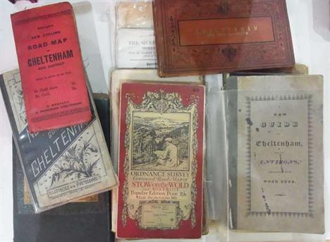
Lot 117
Quantity of ordnance survey maps, maps, guidebooks etc relating to Cheltenham and Gloucestershire, including:- Bath, Bristol, Swindon, Cirencester, Chipping Norton, Stow on the Wold, "Westley's New Cycling Road Map of Cheltenham", "Norman May's Guide to Cheltenham", folding map, "A New Guide to Cheltenham and its Environs", published by John Lee, linen back folding map frontis, original front boards, backstrip missing, front board detached, Williams, J.G.A. "A New Guide to Cheltenham...", printed for G.A. Williams, folding map frontis, folding plates, another map of Cheltenham, foxed, contemporary marbled boards, half leather with gilt titles, a folding map of the Great Western Railway and five other guides and maps, including:- Brighton, Isle of Wight and Oxford etc (27)


Lot 13
A fine William IV mahogany bowfronted mercury stick barometer Troughton and Simms, London, circa 1835. With convex moulded surmount and silvered vernier scale calibrated in barometeric inches and annotated FAIR, Change, RAIN beneath signature Troughton & Simms, London to upper margin, behind bowed glass within moulded surround above trunk with the same bowed profile and ebony strung edges applied with conforming mercury tube Fahrenheit and Reaumur scale thermometer with convex moulded pediment and apron to surround, the base with turned ebony half vase cistern cover flanked by lozenge inlaid canted angles with cavetto moulded underside, 95cm (37.5ins) high. The partnership between Edward Troughton (junior) and William Simms is recorded in Banfield, Edwin BAROMETER MAKERS AND RETAILERS 1660-1900 as formed 1826 and continuing after Edward TroughtonÕs death in 1831, initially trading form the Orrery at 136 Fleet Street the firm moved to 138 Fleet Street from circa 1840. In 1922 the firm was sold and became Cooke, Troughton & Simms Ltd. According to Banfield Edward Troughton was quite a character choosing to live a semi reclusive life and was characterised by his snuff-stained wig and ear trumpet. Edward TroughtonÕs skill both in the manufacture and design of fine Instruments led him to be awarded lucrative contracts from The East India Company, The Board of Ordnance, The Royal Observatory and The Board of Longitude. TroughtonÕs reputation and client list no doubt secured the prosperity of the business for a significant period after his death.


Lot 78
Selection of Canadian Badges and Titles cap badges include bi metal Princess Louise Fusiliers ... KC brass P.P.C.L.I. ... KC darkened Perth Regiment Canada ... White metal Toronto Scottish ... Vic crown blackened and brass Queens Own Rifles of Canada ... QC white metal Queens Own Rifles of Canada ... KC brass RCOC ... QC chrome RCASC ... Pair bullion embroidery and silvered Princess Louise Fusiliers collar badges. Embroidery titles include Princess Louise Fusiliers ... Toronto Scottish ... Perth Regiment Canada ... P.P.C.L.I. ... Royal Canadian Ordnance Corps. 19 items.
Lot 198
Small Selection of WW1 Army Ordnance Corps Medals consisting 1914/15 Star named to Ò01372 Pte C W Bigsby AOCÓ ... 2 x silver War medals named to Ò011182 Pte E Dean AOCÓ ... Ò028193 Pte A Davinson AOCÓ ... 2 x Victory medals named to Ò018385 Pte F Gardiner AOCÓ ÒS5149 A Cpl J R Cromie AOCÓ. 5 items.
Lot 200
Army Ordnance Corps and Officer Single Medals consisting WW1 Victory medal to Ò035795 Pte T Henaughan AOCÓ ... 2 x WW1 Victory medals to ÒLieut N H PullenÓ ÒLieut W C GoslingÓ ... 1914/15 Star named to ÒLieut G Hyde AODÓ. 4 items.Lt later Major Hyde also entitled to Belgium Croix de Guerre LG 23 Apr 1915

Lot 322
WW2 Complete Royal Artillery OfficerÕs Uniform Set consisting khaki green woollen single breasted closed collar battle dress jacket. Pleated chest pockets with buttoned flaps. Embroidery CaptainÕs rank stars. Royal Artillery arm of service. WW2 medal ribbons. Internal Canadian Ordnance stamps ... Matching battle dress trousers with large left leg front pocket. Right hip first aid pocket. Internal Canadian stamps and 1943 date ... OfficerÕs double breasted greatcoat. KC brass RA buttons. RA arm of service. Rank absent ... Khaki single breasted open collar service dress tunic. Bronzed flaming grenade collars. MajorÕs gilt rank. KC brass RA buttons. WW2 medal ribbons ... Matching khaki service dress trousers. All contained in a large ammo transit box. Minor mothing. Quantity.

Lot 685
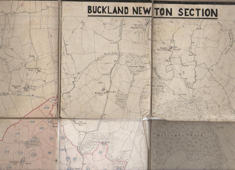
Ordnance Survey Maps. Collection of 22 large scale maps featuring areas of Bedfordshire and Hertfordshire. Early 20th.C. Folding, linen-backed panelled sheets with cloth end-covers. Some annotations and colouring. Together with four other folding maps. CONDITION REPORT: Condition : Some annotations and small sections coloured o/w vg.

Lot 686
Ordnance Survey Map : S. Derby & Notts. Folding, linen-backed map with marbled paper at folded ends. Engraved physical features. Latest date indicated at the lower margin - " Railways inserted to May 1884 ". Part of embossed Ordnance Survey stamp with 'OCT 90' on upper margin. Engraved heraldic bookplate of Edward Matthey on one end. Maroon cloth slip case with Edward Stanford label. CONDITION REPORT: Condition; Vg


Lot 169
Devon. Ordnance Survey,The Second part of the General Survey of England and Wales Containing the whole of Devon and a Portion of the adjoining Counties, done by the Surveyors of His Majesties Ordnance under the Direction of Lt. Col. Mudge of the Royal Artillery, F.R.S., c.1809, eight uncoloured engraved map sheets and an additional calligraphic title sheet, each sectionalised and laid on linen, each sheet with contemp. printed labels to verso of maps, each sheet approx. 610 x 930mm, contained in contemp. red gilt morocco book box with gilt crest of the Ordnance Board to front panel, rubbed and frayed, bumped at extrems. (1)

Lot 736
Assorted militaria - World War I pair, British War Medal and Victory medal to 4998 Pte A. Cox S Lond R; World War II Defense medal; Ordnance Corp cap badge; assorted buttons and a mother of pearl formed icon relating to the Royal Artillery at Dunkirk, all contained in a World War I Christmas tin centred wooden box

Lot 382
Railway interest; GWR Signal Engineers Office, Reading - a diagram of the track and points layout Blue Anchor Station, amended 1934, and a diagram of track and points of Bishops Lydeard, both framed, together with a North British Railway plan for siding at Castlecary Station, dated 1884, Ordnance Survey maps etc. (a lot).


Lot 132
An 1882 Short Pattern Cavalry Trooper's Sword, 83.5cm blade, overall length 101cm, by Robert Mole and Sons, the blade etched with cartouche Robt Mole & Son Maker's Birmingham, regulation steel hilt with Maltese Cross piercing, stamped with various ordnance marks at the forte and 'H.F.B.3' (possibly Hamilton Field Battery) to the hilt, two piece chequered riveted leather grips, in its sheet steel and wood lined scabbard with fixed opposed suspension rings.

Lot 355
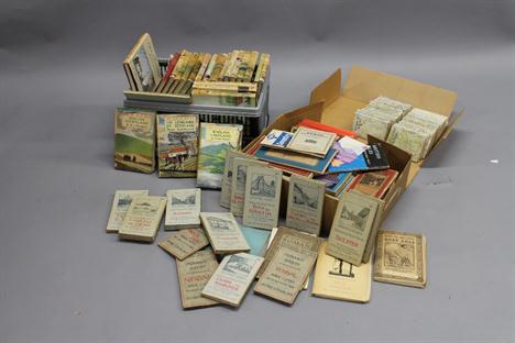
A collection of Maps and Ordnance Survey Maps of Great Britain, late 18th century and later, including Maps of British Counties engraved by John Cary (1754-1835) and published by John Stockdale, from 1798 and later, including Suffolk, Hartfordshire, Surrey, Hampshire, Worcestershire, Wiltshire, Norfolk, South Wales, Nottinghamshire, Somersetshire, Lincolnshire, Warwickshire, Leicestershire, Rutlandshire, Gloucestershire, together with other maps engraved at the Ordnance Map Office in the Tower of London, and other 19th century and later county maps, some with hand colouring, (a lot), (a/f), (unframed)
-
12130 item(s)/page