We found 12129 price guide item(s) matching your search
There are 12129 lots that match your search criteria. Subscribe now to get instant access to the full price guide service.
Click here to subscribe- List
- Grid
-
12129 item(s)/page


Lot 33
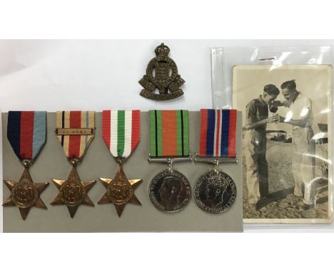
Spannender Nachlass von Auszeichnungen aus dem Deutsch-Französischen Krieg und dem Ersten Weltkrieg. Darunter: Deutsches Kaiserreich: 4 Auszeichnungen auf einer Ordensspange, dabei: 1 x Preußen - Roter Adler Orden Kreuz 4. Klasse (1846-1885), mit Schleife; 1 x Medaille in Kupfer, Avers: 'Landwehr Dienstauszeichnung II. Klasse', Revers: 'Treue Dienste - Reserve Landwehr', von der Spange gelöst, mit blauer Schleife; 1 x Preußen - Kriegsgedenkmedaille für die Feldzüge 1870/71 'Dem siegreichen Heere', umlaufend 'Gott war mit uns - Ihm sei die Ehre', Rand: 'Aus erobertem Geschütz', mit 5 Gefechtsspangen, mit Schleife; 1 x Preußen - Gedenkmedaille 'Zum Andenken an den hundersten Geburtstag des großen Kaisers Wilhelm I. 1797 - 22 März 1897', mit Schleife. Im schwarzen Lederetui, beschrieben mit dem Namen 'C. Th. MENKE.' Dabei in kleinerer Ausführung an einer Nadelkette die oben beschr. Auszeichnungen in Kupfer-Zink vergoldet, sowie die dazugehörigen Schleifenfarben zusammengeführt zu einer kleinen Schleifennadel. Des Weiteren 2 x Auszeichnungen aus dem Ersten Weltkrieg, gewidmet PTE. F. MENKE: 1 x Vereinigtes Königreich - Interalliierte Siegesmedaille 1914-1919, Bronze, Avers: Ganzfigur der geflügelten Siegesgöttin Victoria mit Palmzweig, Revers: 'The Great War for Civilisation 1914-1919', am Rand: Dienstnummer: 59638, Dienstgrad: Private (PTE), Name: F. Menke und Militärseinheit: Devon. R., mit Schleife, in Originalbox; 1 x Vereinigtes Königreich - Kriegsmedaille 'The British War Medal' 1914-1918, Avers: Büste seitlich nach links von George V., Revers: Krieger auf Pferd nach rechts schreitend, Silber, Raugewicht ca. 33.27 g, in Originalbox. Anbei zu diesen britischen Auszeichnungen im originalen Briefumschlag ein maschinell erstelltes Schreiben über die Verleihung einer unbenannten Medaille sowie das Zertifikat nach der Demobilisierung oder nach aktivem Dienst 'Protection certificate and certificate of identity' (Army Form Z.11) des Soldaten Frederick William Menke, Alters- und Gebrauchspuren. Erhaltungen aller Auszeichnungen verschieden. Bitte unbedingt besichtigen!| Exciting legacy of awards from the Franco-Prussian War and World War I. - Including: German Empire: 4 awards on a medal clasp, including: 1 x Prussia - Red Eagle Order Cross 4th Class (1846-1885), with ribbon; 1 x medal in copper, obverse: 'Landwehr Dienstauszeichnung II. Klasse', Revers: 'Treue Dienste - Reserve Landwehr', detached from clasp, with blue ribbon; 1 x Prussia - War Memorial Medal for the campaigns 1870/71 'Dem siegreichen Heere', circumferential 'Gott war mit uns - Ihm sei die Ehre', Rand: 'From Conquered Ordnance', with 5 battle clasps, with ribbon; 1 x Prussia - Commemorative Medal 'In memory of the hundredth birthday of the great Emperor Wilhelm I. 1797 - 22 March 1897', with ribbon. In black leather case, inscribed with the name 'C. Th. MENKE.' With it in smaller version on a pin chain the above described awards in copper-zinc gilt, and the associated ribbon colors brought together to form a small ribbon pin. Furthermore 2 x awards from the First World War, dedicated to PTE. F. MENKE: 1 x United Kingdom - Interallied Victory Medal 1914-1919, bronze, obverse: full-length figure of the winged goddess of victory Victoria with palm branch, reverse: 'The Great War for Civilisation 1914-1919', on the border: service number: 59638, rank: Private (PTE), name: F. Menke and military unit: Devon. R., with ribbon, in original box; 1 x United Kingdom - War Medal 'The British War Medal' 1914-1918, obverse: bust sideways to the left of George V., reverse: warrior on horseback striding to the right, silver, gross weight approx. 33.27 g, in original box. Enclosed with these British awards in original envelope a typed letter of award of an unnamed medal and the certificate after demobilization or active service 'Protection certificate and certificate of identity' (Army Form Z.11) of soldier Frederick William Menke, signs of age and use. Condition of all awards varies. Please be sure to visit!
Lot 478
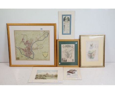
Robert Hancock (1730 - 1817), A New and Accurate Plan of the City of Bath to the Present Year 1793, published by W. Taylor and W. Meyler, 1793, hand-coloured engraving, 47 x 53cm, framed and glazed, Bath from the Ordnance Survey, engraved by J. Henshall, coloured engraving, label verso from The Antique Map Shop, Bath, 'Guaranteed to be a genuine antique map, by Henshall, Date c1837', 31.5 x 19cm, framed and glazed, City of Bath, engraving, label verso from Antique Maps, Earley Maps c.1540 - 1900, Certificate of Authenticity, 'Earley Maps guaranteed this to be a genuine Antique Map as dated, by T. Moule, printed in c.1840', 27 x 20cm, framed and glazed, J. Newman, A view from the Railway Arch over Pulteney Road, coloured lithograph, 22 x 31cm, unframed, General Motors Limited advert, colour print, 26 x 9cm, unframed and The Rover Co. Ltd 1948 advert, colour print, 20.5 x 15.5cm, unframed

![H L Blackmore, "The Armouries of the Tower of London. 1. The Ordnance", HMSO, 1976, 28 cm x 23 cm. [ cannon / artillery ]](https://cdn.globalauctionplatform.com/52a8dfb7-6f19-447e-a5c0-b09f00bcbbd5/48bb70ac-5bc7-45b0-9358-b0a100c6e4ad/468x382.jpg)
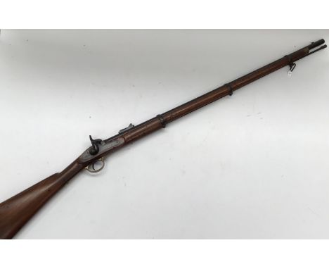
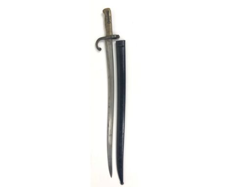
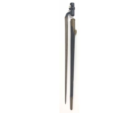
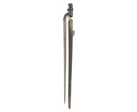
Lot 150
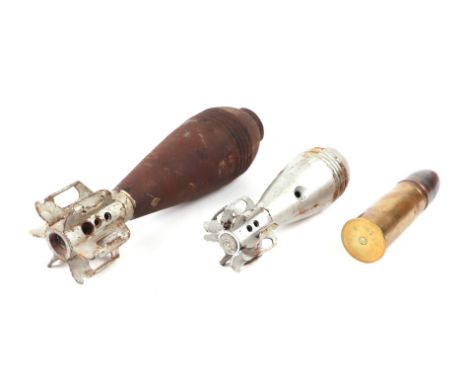
A .577” pattern 1853 Enfield Percussion Commercial Rifle. Made to the regulation pattern, but without ordnance marks. Birmingham proofs, lock with Tower cypher 1859 and stamped ‘Williams & Powell’ into woodwork on opposite side to lock. Williams & Powell were well known Liverpool gun makers in business there from 1840 until very early 1900’s when the business was sold to W.Richards. A typical trade pattern P53 made for commercial sale, of a type referred to as medium quality, as supplied to Colonial Governments, Volunteers, and private individuals. Slight split to woodwork at breech. Proof marks to barrel, missing percussion cap nipple. With ramrod (stuck in housing), barrel length 100cm, Overall length 140cm.
Lot 755
A framed watercolour "The Slipway" by Karen Charman along with two local interest items. An unframed limited edition 132/250 reproduction print of an antiquarian engraving of the "North View of Lyme Cobb" engraved for the history of Lyme Regis and a framed Ordnance Survey map of Whitford 1887 - 1903 featuring Whitford, Maidenhayne, Hampton, Seaton Branch Line and Seaton Junction etc

Lot 315
England and Wales.- Laurie & Whittle (publishers) Laurie and Whittle's New Traveller's Companion: Exhibiting a Complete and Correct Survey of all the Direct and Principal Cross Roads in England, Wales and Scotland: As far North as Edinburgh and Glasgow, fourth edition, title, advertisement page, index, explanation, key map and 25 double-page engraved maps with fine hand-colouring, presented in original wallet-style red morocco with flap, sympathetically rebacked, slightly worn, 4to, 1806 corrected to 1810; together with John Rocque's 'The Traveller's Companion, or the Post Roads of England and Wales', in original slipcase, 1771, and four Ordnance Survey maps, all held together in book-style slipcase, covering Essex, Kent, and Surrey, 8vo, c. 1820 (3)
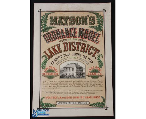
Lot 547
Mayson's Ordnance Model of The Lake District c1870s-80- The scarce poster advertises a three dimensional model of the Lake District - a plaster relief model using the ordnance survey 6" to the mile maps [hence the name] - the model showed the actual physical lay of the land so visitors could plan excursions- An attractive lithograph poster with fern details to the borders [quite the fashion in the 19th century] also partially highlighted with metallic gold ink- Printed in Edinburgh McFarlane & Erskine Lithog-rs, size 11.5" x 15.25"


Lot 305
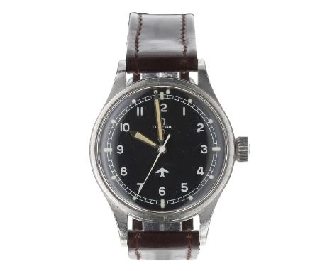
Omega British Military RAF issue pilot's stainless steel gentleman's wristwatch, reference no. 2777-1 SC, serial no. 13058xxx, circa 1951-53, the black dial with Military 'fat' broad arrow and circled 'T' indicating use of Tritium, Arabic numerals, minute track with luminous dot and baton markers and white centre seconds, cal. 283 17 jewel movement, movement dust cover, case with fixed bars and screw back with broad Military arrow and ordnance numbering '6645 101000', air crew issue '6B/542', store number and year '2745/53', modern brown leather strap, 37mm-Box and Papers - no.Movement - currently functioning.Dial - good.Glass - light surface marks.Hands - small crack to the hour hand infill otherwise good.Case - minor light surface marks.Crown - adjusting correctly.Strap - modern, good.-Condition reports are provided for general guidance only. Please view images and further information can be obtained upon request. Gardiner Houlgate do not guarantee the working order or time accuracy of any lots. Due to the opening of the wristwatch case backs, it is recommended watches are re-sealed by professional technicians to ensure any stated water resistance is retained
Lot 234
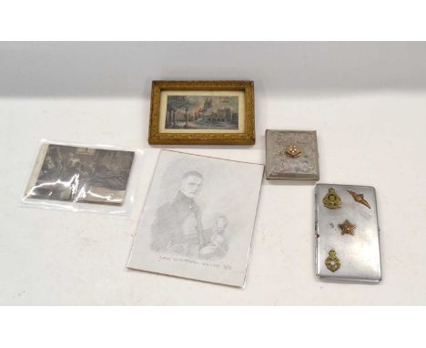
Silver plate cigarette case with SS Duchess of Athol emblem/cartouche to front together with modern sketch, small framed arras 1915 scene souvenir on silk and plate cigarette case of Royal Army Ordnance Corp and Soviet cap badge together with First World War French set of six postcards depicting First World War German soldiers put together resembles a portrait of a gentleman
Lot 64
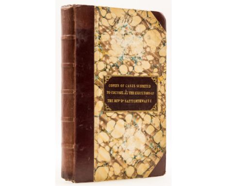
Cumberland.- Satterthwaite (Rev James, son of Lieutenant-Colonel James Clarke, of Papcastle, Cockermouth, Cumberland, educated at Eton, St John's College, Trinity College and Jesus College, Cambridge, Fellow of Jesus College, 1795-1806, Chaplain to George III in 1814, Rector of Bootle, later Rector of Lowther, Westmorland, friend of Christopher Wordsworth, 1773-1827) Copies of Cases Submit[t]ed to Counsel by the Executors of the Rev Dr Satterthwaite, manuscript documents, legal opinions and letters, c. 280pp. (31pp. printed Act of Parliament), in various hands, many items folding, original half morocco, gilt morocco label on upper cover, corners bumped, folio, 1828-30.⁂ Documents concerning various transactions relating to Cockermouth and other areas in Cumberland made by James Clarke Satterthwaite and his son James Satterthwaite.(1). In the Exchequer. Hamilton and another v Blendall and others. Bill and Answers. "The Borough of Cockermouth... All these four Messuages... situate in Cockermouth... adjoining to Derwent Bridge...", 1828.(2). Copy of James Satterthwaite's Will, 1830.(3). To the Commissioners appointed in & by an Act of Parliament... intitled "An Act for inclosing Lands in the Borough and Township of Cockermouth in the County of Cumbd", 1813.(4). J.C. Satterthwaite Esqre to John Dalyell... To the Grassing of one Mare and foal..., n.d.(5). Cockermouth Inclosure, 1822.James Satterthwaite was educated at Eton and Jesus College, Cambridge, where he became a Fellow. He became a rector successively, of Whicham, 1804-14, Bootle, 1807-13, Lowther, 1813-27, and Aikton, 1814-27, all in Cumberland and Westmorland. In 1811 Wordsworth visited Black Combe Fell and wrote the poem, Written with a Slate Pencil, on a Stone, on the Side of the Mountain of Black Comb, while William Mudge and a party of surveyors used the mountain as a triangulation point. It has been suggested that Satterthwaite "had the particulars" about the Ordnance Survey's project "from one of the engineers who was employed in making trigonometrical surveys of the region". Wordsworth and Satterthwaite met during the Bootle holiday in 1811 and, Wyatt suggests, the latter was likely to have been Wordsworth's source of contextual information for the Black Combe inscription. Satterthwaite also corresponded with William Henry Fox Talbot over his method of drying plants. Satterthwaite, through his father had a close connection with the Earl of Lonsdale and the Lowther family who presented him to several livings including Lowther Rectory.

Lot 1281
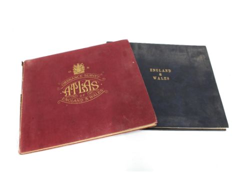
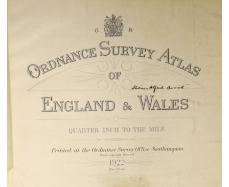
° ° Ordnance Survey Atlas of England and Wales: quarter inch to the mile. engraved title and 24 d-page coloured maps (on linen), errata slip, (2)pp. index map and scales /key, (21)pp. index of places, and extra illustrated with some 21 maps from a contemp. London large scale atlas, mounted on versos of the Ordnance sequence. unlettered cloth, oblong 4to. Southampton: printed at the Ordnance Survey Office, 1922


Lot 473
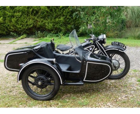
Property of Peter Ardronc.1938 BMW R12 750cc Motorcycle CombinationRegistration no. EOR 189Frame no. 11187Engine no. 36067• Imported into the UK in 1944• Ex-German Army• Present ownership since 2014• Expertly restored with no expense spared (completed 2017)This wonderful R12 motorcycle combination belongs to Peter Ardon, a well-known and highly respected enthusiast within the BMW community (Peter helped restore/commission the 1941 BMW R12 that was sold by Bonhams in 2022). Restoring these older BMWs has always been his passion and he probably has more experience of working on them than anyone else in the UK. Indeed, he founded and ran for several years an international vintage BMW club.'EOR 189' was first registered in the UK in 1944, but BMW have confirmed the October 1938 date of manufacture for the frame and its delivery as part of an R12 to the Army Ordnance Office in Munich. The engine came from another R12 delivered in September 1941 to the Luftzeugamt Küpper (Luftzeugamt = civilian Air Office). BMW's dating letter is on file. It is quite likely that the R12 was a war trophy brought back by a British officer during WW2. The BMW has had six previous owners, the last of whom owned it for over 50 years. He confirmed he had not painted the machine and did not believe it had been repainted since importation. It was covered in a thick, oil based black paint. The story passed down with the machine is that the importer painted over the German Army colours with household black to make it less objectionable in wartime Britain. The original Army colour was still visible underneath the black but was beyond restoration. Peter decided that as the bike had been painted black since (probably) 1944, then restoring it in civilian colours better reflected its history than a return to German Army Grey. Dream Machine of Nottingham were entrusted with most of the repaint. Peter bought this R12 nine years ago and restored it with no expense spared purely for his own use. It has had everything done that it could possibly need, including sending the frame to RRC Tuning in Germany, R12 specialists and the only company in Europe with the experience and tooling necessary to straighten it to as-new tolerances. RRC were also entrusted with the electrical rebuilds, etc and they and Mark Huggett supplied most of the spares. None of the cheap, poorer-quality spares which are available from Poland and elsewhere have been used.One minor gearbox component (which does not in any way affect reliability or how it runs) was not available during the rebuild but comes with the bike should the next owner wish to fit it. Only Peter's ill health has prevented it from fitting it himself. No expense was spared in the rebuild, and Peter says that the machine runs even better than it looks. Purists will spot some reproduction parts but these are all minor, and it is doubtful there is a more practical R12 in the country. The sidecar is brand new and is a quality reproduction of an original Steib. With practicality and stopping-power in mind, Peter has fitted a brake (easily removed) to the sidecar. Poor health has meant that Peter has been unable to use the BMW as intended (he has only managed some 3,500 kilometres) and that is the only reason he is selling it now. The R12 last ran in August 2023. Accompanying documentation consists of Peter's purchase receipt; a photocopy of an old-style continuation logbook (issued 1952); a current V5C Registration Certificate; and numerous receipts for new spares.Footnotes:All lots are sold 'as is/where is' and Bidders must satisfy themselves as to the provenance, condition, age, completeness and originality prior to bidding.For further information on this lot please visit Bonhams.com
Lot 85
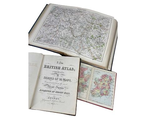
THREE ATLASES, including CHAPMAN & HALL (publ) A New British Atlas, comprising a Series of 54 Maps, 183 and Wales, reduced from the Ordnance Survey,4, half green morocco, gilt tooled spine, marbled boards, 4to, BARTHOLOMEW (J.G.) The Royal Atlas of England containing colour printed maps, George Newnes Ltd.to, and JOHNSTONE (W. & A.K.) (publ.) The Half Crown Historical Atlas, containing colour printed maps, 8vo (3)Provenance: private collection Pembrokeshire
Lot 56
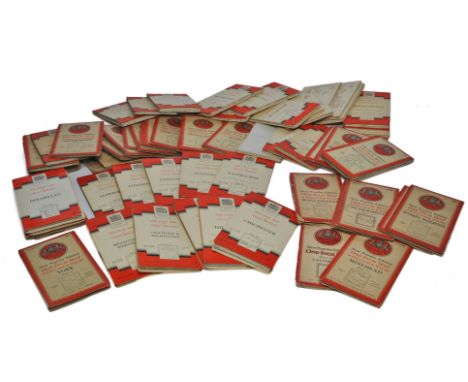
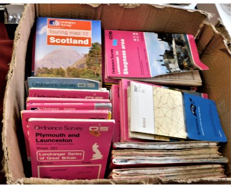
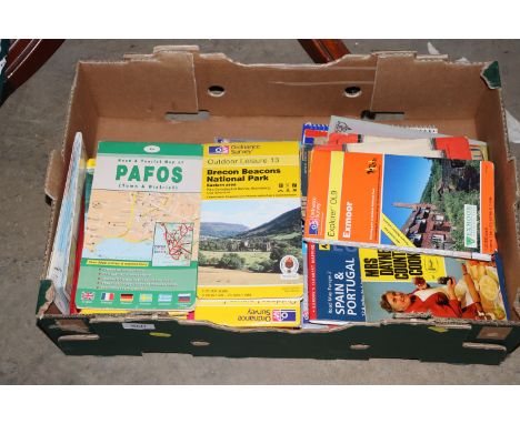
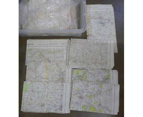
A collection of folding touring maps, 20th century mainly Great Britain from circa 1920s, including Bartholomew, Burrow's RAC, Ordnance Survey, and others; also to include Philip's Large Scale Military Map of the Seat of War on the Natal Frontier, 66 x 52cm, and G W Bacon two-section linen backed folding map of England Wales, for The Chart Publishing Co, Oxford; and - Taschen (publisher) Cities Of The World, complete edition of the colour plates of George Braun & Franz Hogenburg, 2008, dust jacket, in card case

Lot 290
Grouping of Military and Police Badges, including Royal Army Ordnance Corps officers gilt and enamel cap badge, Royal Marines Bandsman cap badge, 2x Worcestershire regiment valise badge, Royal Marines valise badge, Worcestershire Police white metal headdress badge, plus other items. (45 items)
Lot 407
Silver Hong Kong Army Ordnance Rifle Club Regimental Spoon, fine quality example with Hong Kong silver hallmarks to the reverse. Two Army Ordnance and Royal Army Ordnance Corps hallmarked silver spoons; 4x hallmarked silver and plated spoons for the Royal Artillery, hallmarked silver spoon of the Duke of York’s Royal Military School Dover, hallmarked silver and enamel Camberly Staff College and plated Royal Military College spoon. (10 items)
Lot 331
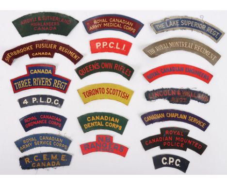
20x WW2 Canadian Printed Regimental Shoulder Titles, including Argyll & Sutherland Highlanders Canada, Canada Three Rivers Regiment, Sherbrooke Fusilier Regiment, 4. P.L.D.G, Royal Canadian Ordnance Corps, RCEME, Royal Canadian Army Service Corps, Royal Canadian Army Medical Corps, P.P.C.L.I, Queen’s Own Rifles, Toronto Scottish, Royal Canadian Engineers, Canadian Dental Corps, N.B. Rangers Canada, C.P.C (Canadian pioneer Corps), Royal Canadian Mounted Police, Canadian Chaplain Service, The Lake Superior Regiment, Lincoln & Welland regiment and The Royal Montreal regiment. Various conditions. (20 items)

Lot 327
12x WW2 British Printed Regimental Shoulder Titles, consisting of Inniskilling Fusiliers, Wiltshire regiment, Pioneer Corps, Royal Army Ordnance Corps, Royal Welch Fusiliers, Auxiliary Territorial Service (A.T.S), RAF Regiment, KRRC, Royal Army Medical Corps, Royal Engineers, Royal Norfolk regiment and Royal Warwickshire regiment. All uniform removed. Various conditions. (12 items)
Lot 218
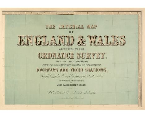
England & Wales. Lewis (Samuel), A Map of England & Wales Divided into Counties, Parliamentary Divisions and Dioceses, Shewing the Principal Roads, Railways, Rivers & Canals and the Seats of the Nobility and Gentry, with the distance of each town from the General Post Office London..., published S. Lewis & Co., 1841, large map engraved by J. Dower with contemporary outline colouring, sectionalised and laid on linen, in four parts (as published), inset map of the Scilly Isles, calligraphic cartouche, compass rose, table of explanation and large uncoloured engraved vignette of the Post Office in London, slight spotting and offsetting, each sheet approx. 1050 x 850 mm, each section bound in contemporary morocco gilt, worn and frayed, size when folded 225 x 145 mm, together with Cary (John). [Cary's New Map of England and Wales with part of Scotland on which are carefully laid down all the Direct and Principal Cross Roads, the Course of the Rivers and Navigable Canals..., 1794], lacking title, but retaining dedication and the general map of England & Wales with contemporary hand colouring, table of explanation, 77 engraved maps with contemporary outline colouring (numbered to 81), tipped in printed addendum of the 'Measured Distances in the Neighbourhood of Plumpton', slight offsetting and dust soiling, 'list of places' and subscriber's list bound at rear, first few leaves detached, some splitting and cracking along the gutter, slight dust soiling and spotting throughout, contemporary half calf, spine partially lacking, upper board detached, heavily rubbed and worn, 4to, with Bartholomew (John). The Imperial Map of England & Wales According to the Ordnance Survey, with the Latest Additions; Shewing clearly every Feature of the Country, Railways and their Stations, Roads, Canals, Rivers, Gentlemen's Seats &c. &c., On a Scale of 4 Miles to an Inch, A. Fullarton & Co., [1866], index and a double-page calligraphic title, sixteen double-page colour lithographic maps, sheet 16 divided into three separate maps, text block detached, contemporary half calf gilt, boards detached, lacking spine, slim folio, plus Bell (James). A New and Comprehensive Gazetteer of England and Wales..., 8 volumes, A. Fullarton & Co. 1837, frontispiece of an 'Extracts of Reviews', title pages with dated contemporary ownership signature to each volume, folding engraved map of England & Wales with contemporary wash colouring and 44 uncoloured engraved county maps by Archibald Fullarton, some spotting throughout, some hinges and joints partially split, publishers green cloth with contrasting paper labels to the spines, bumped, faded and worn, 8vo, together with Cox [Thomas]. Magna Britannia et Hibernia Antiqua & Nova..., volume 3 only, 1724, title page and 3 only (Middlesex, Northamptonshire & Northumberland, lacking Norfolk)) uncoloured engraved folding maps by Robert Morden, each with a triangular mileage table, bookplates of John Basil Tolhurst to the front pastedown and of Prinknash Abbey to the front blank, contemporary vellum with manuscript title to the spine, 8vo, with Capper (Benjamin Pitts). A Topographical Dictionary of the United Kingdom..., Sir Richard Phillips and Co. 1829, frontispiece of an uncoloured engraved folding map of the British Isles, title page, introduction and index, 43 uncoloured engraved maps, preliminaries detached, contemporary quarter sheep, lacking spine, upper board detached rear board near detached, heavily rubbed and worn, 8voQTY: (16)
Lot 244
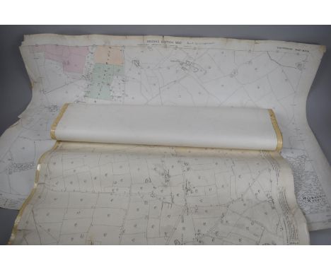
South East England. Ordnance Survey (publishers), on a scale of 1 inch to the mile, 1885, including East Sussex and West Sussex. Two untitled maps, Edward Stanford, 1885, engraved maps with contemporary outline colouring, sectionalised and laid on linen, on two sheets, each sheet approximately 920 x 1360 mm, marbled endpapers, together with Isle of Wight. Edward Stanford, 1885, engraved map with contemporary outline colouring, sectionalised and laid on linen, slight offsetting, 695 x 970 mm, marbled endpapers, with East Kent & West Kent. Two untitled maps, Edward Stanford, 1885, engraved maps with contemporary outline colouring, sectionalised and laid on linen, on two sheets, each sheet approximately 1045 mm, all contained within a contemporary morocco gilt book box, the box heavily worn and frayed, plus Environs of Tunbridge Wells. Ordnance Survey (publishers), on a scale of 25 inches to the mile, Edward Stanford, 1883, seven zincographic maps, coloured in outline, sectionalised and laid on linen, each sheet approximately 690 x 1000 mm, marbled endpapers, all contained within a contemporary morocco gilt book box, the box heavily worn and frayed (the two book boxes are uniform), and Kent. Ordnance Survey (publishers) on a scale of 25 inches to the mile, Thomas Letts, circa 1870, seventeen zincographic maps, coloured in outline, sectionalised and laid on linen, each sheet approximately 680 x 1020 mm, contained in three red half morocco gilt book boxes with marbled sidings and edges, each with 'hook & eye' clasps, one box with the upper board broken with loss QTY: (5)
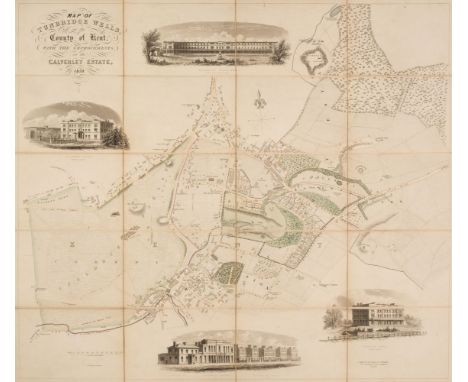
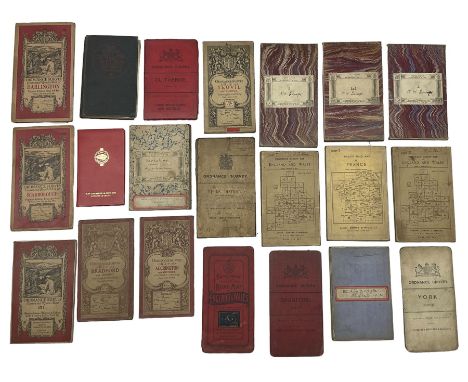
Lot 221
Folding Maps. A collection of twenty-one British & foreign maps, 18th & 19th century, British county maps, regions and foreign countries, including examples by or after Henshall, Smith, Dix, Ordnance Survey, Wallis, Faden, Cruchley, Cary, Bowles and Stanford, various sizes and conditionQTY: (21)
-
12129 item(s)/page