We found 12129 price guide item(s) matching your search
There are 12129 lots that match your search criteria. Subscribe now to get instant access to the full price guide service.
Click here to subscribe- List
- Grid
-
12129 item(s)/page


Lot 1029
A collection of WWII memorabilia comprising a Princess Mary brass box dated Christmas 1914, a quantity of buttons for regiments including Bedfordshires, Royal Armoured Corps, Royal Army Ordnance Corps, ARP etc, also two inert bullets, a brass oil canister, button polishing aid together with a 1941 helmet liner etc.


Lot 397
Edinburgh & Scotland A civic survey & plan for the City & Royal Burgh of Edinburgh. Edinburgh, 1949. First edition, 4to, original cloth, dustwrapper, some marking to wrappers; Geddie, John The water of Leith. Edinburgh, 1896. 4to, illustrated by Joseph Brown, original green cloth gilt, some rubbing to edges; Baird, William Annals of Duddingston and Portobello. Edinburgh, 1900. 8vo, 2 volumes, original green cloth gilt, inner hinges weak; Arnot, Hugo The history of Edinburgh. Edinburgh, 1779. 4to, frontispiece, lacking folding map, modern cloth gilt, browning and foxing; Ewing, Major John The Royal Scots 1914-1919. Edinburgh, 1925. 8vo, 2 volumes, frontispiece, plates, original blue cloth gilt; Turner, A. Logan History of the University of Edinburgh 1883-1933. Edinburgh, 1933. 8vo, original blue cloth gilt; RCAHMS Counties of Fife, Kinross and Clackmannan. Edinburgh, 1933. 4to, original blue cloth, rubbed, ex-library copy; Watson, C. B. & Cowan, W. The maps of Edinburgh 1544-1929. Edinburgh, 1932. 8vo, presentation copy from editor Boog Watson, cloth backed boards; Groome, Francis H. Ordnance gazetteer of Scotland. Edinburgh, 1886. 8vo, 6 volumes, original cloth gilt, water staining to boards and some interior pages; and 39 others (55)

Lot 945
Aviation - A mahogany planter, made from the propeller of a Fairey IIID, marked to base `Made From The Propellor of a Fairey IIID 1929` 37cm high A Mounted Indirect Ordnance Fuse, marked No.199 IV FL 10/38 & RL 12/38 537., 10.5cm high. The Fairey IIID seaplane was built by the Fairey Aviation Co. Ltd. as a development of their 1917 F127 reconnaissance seaplane design for the Royal Naval Air Service, the IIID had a more powerful Rolls Royce Eagle VIII engine and entered service in 1924.

Lot 730
* S.O.E. Suitcase Radio Type 3 Mk II, Serial No. 90367. A rare example of the 1943 pattern “suitcase radio”, supplied to and used by agents of the Special Operations Executive created by Winston Churchill shortly after the outbreak of WWII, and charged with the mission of “setting Europe on fire”, this set complete in its fitted suitcase covers 3-15.5 mc, and uses EL32 and 6L6 tubes in the transmitter providing a power output of 30 watts, various controls include a Meter Selector, Aerial Matching, Anode Tuning, P A Grid Tuning, Waveband and Crystal selectors, also with B.F.O. and volume controls, embossed brass label giving instructions, plugs, sockets, with LT 10 amp and AC 1/2 amp fuses and “on/off” switch, all neatly packed within four units and arranged in the original leatherette suitcase with twin locks and carrying handle, 18in (45.7cm) wide, some old damage to back of suitcase lid and scuffing. Ref. The William L. Howard Ordnance Technical Intelligence Museum, 219 Harborview Lane, Largo, Florida 33770. (1)

Lot 310
Kent. Faden (William, pubs.), General Survey of England and Wales. An Entirely New and Accurate Survey of the County of Kent with part of the County of Essex, done by the Surveying Draftsmen of His Majesty’s Honourable Board of Ordnance, ........ under the direction of Capt. W. Mudge of the Royal Artillery, 1801, uncoloured engraved map sectionalised and laid on linen, on four sheets, calligraphic title and dedication, very slight off-setting, each sheet approx. 610 x 890mm, with contemp. waxed card chemise, contained in contemp. sheep gilt solander box with contrasting morocco label to spine, rubbed and worn. A fine example of the detail, accuracy and cartographic skill deployed on the early Ordnance survey maps.. (1)
Lot 335
Ordnance Survey. Country Around Faringdon, 1887, engraved map with original outline colouring, sectionalised and laid on linen, from Charlbury in the North to Swindon in the South and from Oxford in the East to Cirencester in the West, slight marginal staining, 680 x 980mm, contemp. red morocco gilt boards with gilt title and later label to upper board, together with Dorset, 1811, uncoloured engraved map of the country around Sherbourne, 630 x 795mm, with, Smith (C.), A New Map of the County of Devon Divided into its Hundreds, Jan. 6th. 1804, engraved map sectionalised and laid on linen, original hand colouring, 450 x 495mm, contemp. printers label to end paper, contained in near contemp. card slip case with printed label at foot, with, Hickman and Kinch (pubs.), A Guide to Henley-on-Thames and its Vicinity, 1850, contemp. manuscript ownership inscriptions to front paste down and first free end paper, hinges weak, contemp. cloth gilt, worn and faded, 8vo, with, Rocque (John), A Topographical Map of the County of Berks, by John Rocque, Topographer to his Majesty, 1761, facsimile ed. pub. Harry Margary, Lympne Castle, 1973, dec. folding title page, half title, general map of Berkshire with inset town plan of Oxford & eighteen folding map sheets, pubs. cloth boards with printed label to upper board, folio (5)
Lot 336
Ordnance Survey. West London, Middlesex & Berkshire, 1st. August 1822 uncoloured engraved map, sectionalised and laid on linen, stretching from London in the East to Maidenhead in the West, Berkhamstead in the North and Staines in the South, 630 x 935mm, cloth end papers, contained in contemp. cloth slip case, rubbed and stained, together with, Pembrokeshire, 1818 & 1819, two uncoloured engraved maps, sectionalised and laid on linen, each approx. 630 x 935mm, contained in two contemp. green `envelope style’ green morocco slip cases, (one flap detached), one with gilt title to spine, rubbed and worn (3)
Lot 21
Farnham (George F.) Leicestershire Medieval contemporary half morocco rubbed Leicester 1925; Leicestershire Medieval Village Notes introduction by A. Hamilton Thompson 6 vol. bookplates of Franck Greenhill contemporary cloth little rubbed Leicester [1929-] 1933 § Domesday Book. Facsimile of the Part Relating to Leicestershire [Rutlandshire] 2 parts in 1 titles and facsimiles in red and black with transcripts and translations some spotting original morocco-backed blind-stamped cloth front cover gilt Southampton Ordnance Survey 1862 folio(8)
Lot 78
Seymour (W.A.) A history of the ordnance survey 1980 § Robinson (A.) Marine cartography in Britain Leicester 1962 § Scenery of Great Britain and Ireland (Life in England)...the library of J.R.Abbey 2 vol. limited to 500 & 400 copies 1952-53 plates original cloth dust jackets (last 2 a bit worn); and others bibliography v.s.(c. 40)
![Wallis.Outline or Skeleton Maps..Cornwall [all published] 13 lithographed maps occasional foxing or soiling unbound small hol](http://lot-images.atgmedia.com/SR/1574/2792474/109-201041615643_468x382.jpg)

Lot 165
An interesting collection of local interest comprising six photograph albums of road and building work undertaken around the Congleton, Timperley areas by `Ashley construction` of Hartford, Northwich during the 1950s also an early 20th century fold out ordnance survey map with classification of roads in various colours, also in this lot are three cardboard boxes containing glass negatives dated 1895 of local interest including a farmyard scene with a horse and cart bearing the time trustees of the late Earl of Stanford and Warrington Ashton under Lyne, also scenes from Anglesey including the Menai Bridge and Amlwch


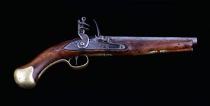
Lot 41
RARE INDIAN FLINTLOCK TURN ABOUT REPEATING FOWLING PIECE CIRCA 1770 with engraved back action lock, the cock with strengthening piece to the back and front with engraved decoration of scrolls and foliage on the lock plate and cock, the pan with five spheres inset into the pierced side, the gilt metal action (Lorinzoni system) with a short lever forward of the gilt trigger guard (when depressed operates the barrel catch to enable the barrel to be rotated, this then cocks the action, loads the chamber from the two cylinders below the single barrel and closes the pan cover in readiness to fire) the two stage single barrel, octagonal at the breech with a gilt metal mask of an Indian woman with her shoulders forming the fore end cap (for the powder and ball barrels), walnut short stock inlaid with scrolls of silver wire, shaped gilt metal butt plate with three shaped scallops each side, triple teardrops at the hand, long scrolled gilt metal trigger guard and long engraved strap below the barrel 54in. (137cm) overall Provenance: Ex armoury of the Nizam of Hyderabad. Note: The stock had rat damage, which was restored by Holland and Holland. The fine quality of this firearm and its distinct Indo French design suggest that it was built under the supervision of General Raymond, who was Controller of Ordnance for Nizam Ali Khan, circa 1780. Two similar weapons are in the Royal Collection at Windsor Castle: RCIN 90672 (Charlton House 3011, Laking 413) Flintlock repeating gun, French circa 1785, barrel inlaid in gold Chalembrom, lock engraved APONDICHERY; RCIN 90673 (Charlton House 540, Laking 430) dated A.H 1212? (AD 1802), marked with initials HIDR. Published in Laking, G F., Windsor Castle Armoury, Badbury & Agnew & Co, London 1904, and Blackmore, H L., Royal Sporting Guns at Windsor, HMSO, London 1968.
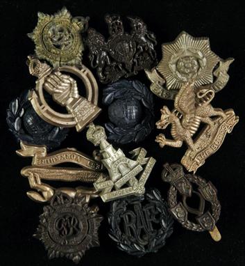
Lot 205
* Military badges and insignia. A group of twelve plastic cap badges comprising:- West Yorkshire Regiment, RAC, RASC (2), Royal Marines(2), Green Howards, East Yorkshire, General List, RAF, REME & The Buffs, together with approx. 20 overseas cap badges including Cape Breton Highlanders, Canadian Provost Corps, NZ Hauraki, RNZ Signals, Royal Winnipeg Rifles, 48th Canadian Highlanders, Indian Army Ordnance Corps, Royal Australian Army Ordnance Corps, South Africa and unidentified (possibly Indian?) etc., plus approx. 40 metal shoulder titles including APTS, ACC, RM (large), RM (small), Green Howards, Royal Norfolk, NGH, R. Warwickshire, Cheshire, Stafford, Kings Own Border, Devon & Dorset, QO. Highlanders, HAC (small), HAC (large), Hants, Gordons, Royal Sussex, R. Signals, KSLI, R. Hampshire, N Grenade F, NR, R.W. Kent, Kings Own, Devon & Dorset, King’s, RAPC, RASC, Northampton, Cheshire, United Services, Worcestershire, Buffs, PWV, Royal Berks, East Anglia, Yorkshire, OTC Dover College and OTC Dulwich College, plus 40 metal collar badges , Victorian and later, and 25 x Aluminium Staybright anodized cap badges (12)
Lot 268
Forbes (A.). A History of the Army Ordnance Services, 3 vols., pub. Medici Society, 1929, folding maps, illustrations, endpapers lightly browned, original blue cloth gilt, chipped and rubbed d.j. to vol. III only, 8vo, together with A History of the Army Medical Department, by Lt.-Gen. Sir Neil Cantlie, 2 vols., 1974, b & w illustrations, original cloth d.j.s, 8vo, plus The Suffolk Regiment 1928 to 1946, by Col. W.N. Nicholson, [1948], portrait frontispiece, maps and plates, previous owner inscription, original red cloth, a little rubbed, front panel of d.j. only, 8vo, with others related including The 10th Royal Hussars in the Second World War 1939-1945, 1948, Loyal Volunteers of London and Environs, Infantry and Cavalry in their Respective Uniforms, 1972 and Bryn Owen’s Welsh Militia and Volunteer Corps 1757-1908, 2 vols., 1989-90 (30)
Lot 203
Ordnance Survey. A mixed collection of approx. seventy-five early Ordnance survey maps, c. 1830-50, engraved b & w maps, sectionalised and laid on linen, some dust soiling throughout, including maps of Devon, Cornwall, Cheshire, Derbyshire, Hampshire, Lancashire, Lincolnshire, Sussex, Dorset, Somerset, Isle of Wight, Gloucestershire, Staffordshire and parts of Wales, each sheet approx. 300 x 350mm (approx.75)
Lot 30
Yorkshire. Cruchley (G.F.), Cruchley’s Railway & Telegraph Map of Yorkshire Showing all the Railways & Names of Stations, also the Telegraph Lines & Stations Improved from the Ordnance Surveys, n.d. c.1865, folding lithographic map with original outline colouring, calligraphic title, some near contemp. ink annotations,485 x 545mm, orig. printed paper wrappers, contemp. ink ownership inscription, slight fraying, together with Collins (H.G.),Yorkshire, n.d. c.1858,folding lithographic map with original outline colouring, sectionalised and laid on linen, slight staining, 700 x 870mm, orig. cloth with printed label to upper board, with,Harding (J.W. & Co. pubs.),Map of Huddersfield District, 1922,decorative folding colour printed map, margins with colour printed advertisements for local businesses, 745 x 550mm, orig. printed paper wrappers, with Sampson (John pubs.),Map of the York and Ainsty Hunt Dedicated by Permission to Captn. Slingsby, Scriven Park, and Members of the Hunt, York, 1881,colour printed lithographic map, sectionalised and laid on linen, compass rose, list of meets and explanation table, 860 x 960mm, comtemp. gilt and blind embossed cloth boards, together with another thirteen folding maps, various sizes and condition (15)


Lot 708
A Guide to Cockermouth, by John Askew, second corrected edition and enlarged, printed and published by Isaac Evening, 22 Station Street, together with a Daily Herald road map of Great Britain and Esso road map of Northern England and an ordnance survey map "Irish Sea" including Cumbria. NOTE - this lot is being sold on behalf of Cumbria Community Foundation for the benefit of flood victims.

Lot 57
A 25-Bore Arsenal Shortened Flintlock Long Sea Service Pistol, “H.M.S. VictoryÕ, late 18th/early 19th century, with plain barrel, tang and lock with “GRÕ crowned and “TowerÕ across the tail, full stock stamped with Board of Ordnance mark, behind the apron, regulation brass mounts including butt-cap engraved in capitals “H.M.S. VictoryÕ d “37Õ to lock-plate, wooden ramrod and ordnance proof marks, no regulation belt-clip, possibly the pistol was held within the ship’s armouries, the number 37 denoting a rack space. 23cm barrel. Provenance: After the Battle of Trafalgar and much damaged the Victory was towed to Gibraltar and finally returned to Portsmouth, arriving on the 4th of December 1805, bearing the body of her dead Admiral. After repairs at Chatham, the Victory was recommissioned in March 1808. For the next four years she was on active service in the Baltic and off the coast of Spain and Portugal. In 1812, now forty seven years old, she finally returned to Portsmouth on the 4th of December and paid off sixteen days later, ending her sea-going life.

Lot 142A
A Great War Group of Four to Sergeant E. T. Andrews, Army Ordnance Corp, 1914 Cross (S-7001 Pte. E. T. Andrews A.O.C.), British War & Victory Medals (S-7001 Pte. E. T. Andrews, A.O.C), Army Long Service & Good Conduct Medal, GRV (7575248 Sjt. E. T. Andrews. R.A.O.C), mounted for wearing, fine if not better.
Lot 767
A French 14 bore military flintlock holster pistol, 15” overall, barrel 9” with octagonal breech, standard pattern lock with incised brass pan and ring neck cock, halfstocked with crowned “N” ordnance mark on the butt, regulation brass mounts with belt swivel on the butt, original steel ramrod. WO & basically GC GC (lock and barrel have been pitted and cleaned, stock worn)
Lot 806
An Afghan .577” military pattern percussion holster pistol, 14¾” overall, rifled barrel 8½” cut down from an Enfield rifle, the lock marked with crowned “VR”, “1866 Enfield” and Indian ordnance mark, assembled with Afghan stock, mounts and swivel ramrod. GWO & Generally GC; also a Continental 60 bore percussion boxlock pocket pistol, 7½” overall, octagonal barrel 3”, WO & basically GC. (2)


Lot 359
Miscellaneous group of letters, ephemera etc, including letters relating to an overcharged bill to the Ordnance Survey for information in the preparation of maps, dated 1855, a bookseller’s sales catalogue dated 1847, a copy of the Northern Daily Express for November 17th 1859, a group of letters concerning Syria, a series of letters by the architect Sir Charles Miles Lambert Monck (1850s), a booklet produced on HMS Flora in 1901 and sundry other letters etc. Note: miscellaneous lot not subject to return.
-
12129 item(s)/page