We found 12129 price guide item(s) matching your search

Refine your search

Year

Filter by Price Range
  • List
  • Grid
  • 12129 item(s)
    /page

Lot 590

First World War Prisoner of War pair, to include War and Victory medals, (01172 PTE.W. HAWKES. A.O.C.) together with badges, two Prisoner of War badges with the impressed text Aushebungsbezick Neustrelitz, and punctual attendance medals, William David Hawkes was a Private in the Royal Army Ordnance Corp and then the Royal Irish Fusiliers, he was fighting in France 1 year 10 months and a Prisoner of War 10 months

Lot 666

Mentioned in Dispatches First War Victory medal, oak leaf, (MAJOR C.W. BATTERSBY) Charles Worsley Battersby was a Major in the Royal Army Ordnance Corps, together with a copy of The London Gazette

Lot 432

22 Ordnance Maps including London, Colonel Colbey 1834 (some staining)

Lot 439

Victorian Ordnance survey tins in the form of books (12)

Lot 678

Aircraft Recognition. A complete set of recognition handbooks, 8 volumes, depicting civil and military aircraft of the 1940s, also included are two Air Ministry recognition handbooks of British Aircraft from the same period along with approximately 600 individual cards and a collection of recognition ephemera, together with a collection of 11 original RAF (WAR) 2nd edition clothed backed Ordnance Survey Aeronautical Maps, covering areas including South and East London, North Midlands and Lincolnshire, South Wales, Glasgow Oban and the Southern Islands, The Forth and Tay, Midlands(South), South England, Midlands(North), The Border, North West England and South West England (a carton)

Lot 281

Three Middle Eastern white metal and filigree niello brooches and various Royal Ordnance Corps brass buttons and various other related pins, etc

Lot 318

GB Ordnance Survey Maps, a large collection of maps, mostly 1960's, 120 approx; other items

Lot 51A

Motor Repair and Overhauling, vols 1-4 with data sheets, published by George Newnes, circa 1947-48, and five Ordnance Survey one inch scale road maps.

Lot 62

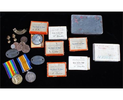
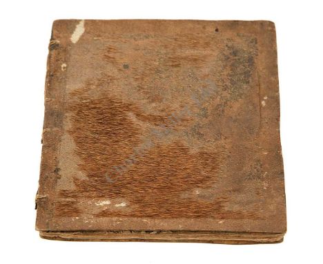
A UNIQUE ALBUM OF CONTEMPORARY WATERCOLOURS OF THE FRIGATE H.M.S. JASON BY THE SHIP'S CARPENTER, AND BOUND IN MONKEY SKIN, CIRCA 1805, compiled by Thomas Harris and comprising ships drawings, manuscript on paper, 7 watercolour drawings of ships' details, the second one with a Union Jack and an early 19th century pen and ink drawing of a figure, and 5pp describing ordnance Dementions of 1st Rate 110 Guns 2764 Tons, etc. Bound exotically in monkey skin, a little worn, contained in a recessed space in a modern green morocco chemise, c.1805. With an inscription on the inside cover of the book: This book was written and drawn by Thomas Harris cabinet maker, of Shrewsbury. He was formally ship carpenter to the Jason frigate and made a model of it which I bought. He gave me this book at that time about June 1836. The binding is made of the skin of a monkey be brought from Jamaica -- 4½ x 3¾in. (11.5 x 9.5cm.), The Jason was a 32-gun fifth rate Thames Class frigate, launched Woolwich 1804, she became flagship to Admiral Alexandre Cochrane in June 1805 and, serving in the Leeward Islands, enjoyed a lively career. Capturing several French and Spanish vessels (including the Naiade after a nine hour chase), she was handed over to Capt. Thomas John Cochrane (the Admiral's son) and continued much as before. Frigate actions, reducing batteries, and surviving an attempted mutiny whilst in New York, her last acts were to serve as escorts to the restored French King, Louis XVIII, and the Prussian and Russian Emperors during the peace negotiations that heralded the end of the Wars in 1815. Worn out, she was broken up shortly afterwards.

Lot 392

TWO BOXES OF MISCELLANEOUS CHINA, GLASS, METALWARE, BOOKS ETC to include The Cotswolds - an Ordnance Survey half inch scale map 1931

Lot 623

Congreve Billy: a hand painted print, 'The Assiduous blown up with Sham Ordnance', 24 by 33cm.

Lot 147

Large collection of maps to include Ordnance Survey

Lot 858

Large Scale ( 1/2500 ) Ordnance Survey Sheet Maps Featuring locations like Corby, Oundle, Lutton, Ringstead, Geddington & Chelveston. Dates from 1920s - 1940s. CONDITION REPORT: Small closed tears to edges and creases but generally clean and bright. Rolled.

Lot 194

A COLLECTION OF TWENTY FIVE EARLY 20TH CENTURY ORDNANCE SURVEY MAPS, mainly of Shropshire and the surrounding area to include Sutton, Meole-Brace, Shrewsbury, etc. Including local land marks, Railways and Canals. Mainly 1/2500 scale.

Lot 195

A COLLECTION OF TWENTY FIVE EARLY TO MID 20TH CENTURY ORDNANCE SURVEY MAPS, mainly of Staffordshire and the surrounding area to include Wolverhampton, Bilston, etc. Including local land marks, Railways and Canals. Mainly 1/2500 scale.

Lot 196

A COLLECTION OF TWENTY FIVE EARLY TO MID 20TH CENTURY ORDNANCE SURVEY MAPS, mainly of Staffordshire, Wolverhampton and the surrounding area to include Tettenhall, Trysull, Featherstone, etc. Including local land marks, Railways and Canals. Mixed scales of 1/2500 and 1/10,560.

Lot 197

A COLLECTION OF TWENTY FIVE EARLY 20TH CENTURY ORDNANCE SURVEY MAPS, mainly of Wolverhampton and the surrounding area to include Tettenhall, Seisdon, etc. Including local land marks and Canals. Mainly 1/2500 and 1/1250 scale.

Lot 198

A COLLECTION OF TWENTY FIVE EARLY 20TH CENTURY ORDNANCE SURVEY MAPS, mainly of Wolverhampton and the surrounding area to include Compton, Finchfield, Tettenhall, etc. Including local land marks and Railways. Mainly 1/1250 scale.

Lot 199

A COLLECTION OF TWENTY FIVE EARLY 20TH CENTURY ORDNANCE SURVEY MAPS, mainly of Staffordshire, Wolverhampton and the surrounding area to include Dunstall Park, Oxley, etc. Including local land marks and Canals. Mainly 1/1250 scale.

Lot 200

A COLLECTION OF TWENTY FIVE EARLY 20TH CENTURY ORDNANCE SURVEY MAPS, mainly of Staffordshire and the surrounding area to include part of the Great Weston Railway line, Dunstall, etc. Including local land marks and Railways. Mainly 1/1250 scale.

Lot 201

A COLLECTION OF TWENTY FIVE EARLY 20TH CENTURY ORDNANCE SURVEY MAPS, mainly of Staffordshire, Wolverhampton and the surrounding area to include Blakenhall, Fordhouses, etc. Including local land marks and Railways. Mainly 1/2500 and 1/1250 scale.

Lot 202

A COLLECTION OF TWENTY FIVE EARLY 20TH CENTURY ORDNANCE SURVEY MAPS, mainly of Staffordshire, Wolverhampton and the surrounding area to include Bank's Brewery, Dunstall Hill, etc. Including local land marks, Railways and Canals. Mainly 1/1250 scale.

Lot 203

A COLLECTION OF TWENTY FIVE EARLY 20TH CENTURY ORDNANCE SURVEY MAPS, mainly of Staffordshire, Wolverhampton and the surrounding area to include Stow Heath, New Cross Hospital, Monmore Green Stadium, etc. Including local land marks, Railways and Canals. Mainly 1/1250 and 1/2500 scale.

Lot 204

A COLLECTION OF TWENTY FIVE EARLY 20TH CENTURY ORDNANCE SURVEY MAPS, mainly of Staffordshire, Wolverhampton and the surrounding area to include Willenhall, Wednesfield, Essington, etc. Including local land marks, Railways and Canals. Mainly 1/1250 and 1/2500 scale.

Lot 205

A COLLECTION OF TWENTY FIVE EARLY 20TH CENTURY ORDNANCE SURVEY MAPS, mainly of Staffordshire, Wolverhampton and the surrounding area to include Bushbury, Essington, etc. Including local land marks, Railways and Canals. Mainly 1/1250 scale.

Lot 206

A COLLECTION OF TWENTY FIVE EARLY 20TH CENTURY ORDNANCE SURVEY MAPS, mainly of Staffordshire, Wolverhampton and the surrounding area to include Pattingham, Billbrook, Codsall, etc. Including local land marks and Railways. Mainly 1/2500 scale.

Lot 207

A COLLECTION OF THIRTEEN EARLY 20TH CENTURY ORDNANCE SURVEY MAPS, mainly of Staffordshire, Wolverhampton and the surrounding area to include Bridgnorth, River Seven, Selly Oak, etc. Including local land marks, Railways and Canals. Mainly 1/12500 and 1/10,560 scale.

Lot 448

A Watercolour depicting Speke Hall, signed indistinctly lower-right, 48 x 37cm, a mid 20th century ordnance survey map of central Liverpool and various further pictures and books relating to Liverpool.

Lot 393

Indian Army post Independence. Medical and Ordnance Corps and Electrical & Mechanical Engineers Insignia. Carded display of the three units including cap badges, collars, titles, buttons and waist belt plates. (35 items) Illustrated at www.mycommissionbid.com

Lot 532

Royal Army Ordnance Corps Falklands War, Northern Ireland Pair of Medals. Awarded to “24511018 PTE P.H. CROSS RAOC.” Comprising General Service Medal with clasp “Northern Ireland”, “PTE RAOC”, South Atlantic Medal with rosette, “PTE RAOC”. Medals loose.

Lot 640

Devonshire Regiment interest 1st Bn Standing Orders ... Ordnance Survey mao of the Solent ... No.6 Hunting Map by Swiss of Dorset etc (Card covers AF) ... No.9 similar of Hampshire etc ... H Coy 2 Section 1903 Manoevre Maps ... OS Map of Colchester 1898. (6 items)

Lot 208

H. Smith and others - Ordnance Survey Map of Ireland, folding lithographed map of four sheets in various sections backed onto linen, most sections approx 17cm x 12cm, within original cloth slipcase, together with a collection of maps.

Lot 1

A boxed 14ct gold Naval bar brooch with seed pearl encrusted crown with safety catch. Bar and crown marked 14ct. Weight 2.9g. Box marked Speciality Naval Jewellery, M.B. Lanyon, Goldsmith & Jeweller, 4, Ordnance Row, The Hard, Portsmouth. Measures approx 4.8cms.

Lot 324

A GOOD SELECTION OF ORDNANCE SURVEY AND OTHER ONE INCH SCALE FOLDING MAPS

Lot 512

A box of ordnance survey maps

Lot 83

Ward Lock & Co Illustrated Guidebooks, Whitby, Edinburgh, Scarborough, Folkestone, Colwyn Bay, Bexhill, Inverness amongst others, together with a quantity of vintage ordnance maps.

Lot 62

A collection of ten Ordnance Survey Maps, Military edition, seven printed on linen, three printed on paper, 1 17th century style map of North West England and a similar map of South West England (12)

Lot 200

Omega British Military RAF issue pilots stainless steel gentleman's wristwatch, ref 2777-1, movement serial no. 13056893, circa 1953, the black dial with Arabic numerals, luminous dot markers and centre seconds, with Military 'thin' broad arrow, cal. 283 17 jewel movement with inner cover, the case with fixed bar lugs and screw back with broad Military arrow and ordnance numbering 6645-101000, air crew issue 6B/542, store number and year 10200/53, NATO style band, 37mm

Lot 415

National Grid Ordnance Survey - One-Inch Map Of Great Britain. Sheet 176 Exeter, Published 1946. Good.

Lot 414

National Grid Ordnance Survey - One-Inch Map Of Great Britain. Sheet 146 Buckingham, published 1946. Good.

Lot 416

National Grid Ordnance Survey - One-Inch Map Of England and Wales. Sheet 133 Northampton, published 1946. Good.

Lot 418

Reprint of the first edition of the one-inch Ordnance Survey of England and Wales, Bedford and Northampton. Sheet No.53

Lot 179

Glass and mahogony chess board, vintage first aid medical box, rulers, Ordnance survey maps etc, (quanity in one box).

Lot 428

A selection of vintage road maps, by Bartholomew's s, some early examples , Bacons Cycling Road map of England sheet 6, Edwardian Ordnance Survey Map of the Isle of Wight together with a hand seal, Sheaffer fountain pen, and Conway Stewart pen set .

Lot 777

Sixteen maps including East Midlands Ordnance Survey maps

Lot 689

Britains boxed set 1265 18 inch Heavy Howitzer garrison mounting Gun No. 1, 1920s version, VG in G box, with additional ordnance, F, 2 loading plates, 5 shell cases (2 each of sizes 1 & 2, 1 of 3), 9 shells. All ordnance repainted in consistent colours. Box complete though slightly worn.

Lot 844

Military, a collection of approx 95 cap badges, various Regiments inc. South Staffordshire, Leicestershire, PTI, Gloucestershire, Royal Guernsey, Essex, RAF, Devonshire, Lancashire Fusiliers, HAC, West Riding, Royal Canadian Ordnance Corps etc. A few shoulder titles also included (gen gd)

Lot 268

Pollyanna Pickering, after, Labrador; another, Grey Mare; John Littler, after, Bakewell Bridge; Ordnance Survey Map on Bakewell (4)

Lot 255

A 17 bore percussion conversion Yeomanry holster pistol, barrel 8.5 in. with Gunmaker's Company proof marks and partial ordnance proof mark, border engraved lock signed 'LACY & CO', full stock with brass furniture, captive ram rod.

Lot 249

A scarce and interesting Fitzgerald patent flintlock signal trumpet, converted musket with private Ordnance proof marks and double bridle lock signed 'FOWLER', barrel truncated and fitted with a threaded brass collar to accept a brass and copper 'trumpet' with widely flaring mouth, walnut stock with brass furniture, trumpet with embossed plate bearing Royal Arms and the legend 'FITZGERALD PATENT SIGNAL TRUMPET SOLD BY APPOINTMENT THO CLIO RICKMAN', early 19th Century. Willam Fitzgerald was granted English Patent No. 2288 in 1799 covering a system for converting guns to amplify their muzzle report, making small arms a more efficient alternative to cannon for signalling purposes or, as the patent specification states "in every case in which the increase ...of sound may be desired". The Board of Ordnance purportedly found that "with the charge of a musket cartridge, it is equal to a nine pounder" Thomas Clio Rickman was the sole retailer. References: Blackmore, 'Gunmakers of London'; 'Repertory of Patent Inventions', printed by John Nichols, Fleet Street, 1799.

Lot 195

Books: New large scale Atlas of the British Isles from the Ordnance Survey with plans of towns, edited and published by George W. Bacon 127 Strand; The Harmsworth Atlas and Gazeeter and other encyclopedia from the series, and various other books including some leather bindings

Lot 497

Various maps of Lincolnshire, issued by the Ordnance Survey office in Southampton, to include villages such as Althorpe, Derrythorpe, Owsten Ferry, etc.

Lot 498

A quantity of maps, issued by the Ordnance Survey office, to include second editions in 1908, 1907 etc., to include villages such as Barnetby the Wold, Twigmoor, Roxborough, Coleby, Holton le Moor, North Kelsey, Grasby etc.

Lot 377

Various books, to include an auction catalogue for the sale of the Norton Disney estate, a copy of Nouveau Riches to Nouveau Pauvers, written by Ian Macalpine-Leny, signed by the author, ordnance survey map of the road between Lincoln and Grimsby and a book on the parish memorials relating to Norton Disney, published 1893

Lot 498A

A large quantity of maps, issued by the Ordnance Survey office in Southampton, various editions to include second edition of 1906 and 1904, to include towns such as Horncastle, Thorpe on the Hill, Torksey, plan of the Burton Estate in Lincoln, Broxholme, Broadholme, Nettleham, Washingborough, Dunholme, etc.

Lot 315

Box of assorted maps to include: Ordnance survey Swansea and the Gower, sheet 159, first series, Great Britain, 7th series, Ordnance Survey Tenby, first series, etc.

Lot 295

A large collection of mainly Ordnance Survey Maps, USA, Europe, West Indies, British Isles, USSR, Africa, United States, South America, etc, mostly folded and coloured, 1930-50s; G+

Lot 887

A Bedales and district 66 inch ordnance survey map, photographs from a 1920s family holiday, etc

Lot 265

A SELECTION OF PRE AND POST WAR BRITISH ORDNANCE SURVEY MAPS

Lot 267

A set of eighteen early Ordnance Survey maps, linen backed, 1:4 scale

Loading...Loading...
  • 12129 item(s)
    /page

Recently Viewed Lots