
*British Navy. A group of five manuscript documents addressed to the 'Respective Officers of His Majesty's Ordnance at Portsmouth, 6th November 1770 to 5th July 1784, the first concerning the details for replacement of six guns thrown overboard by the Sloop Officer, signed Tho. Hartnell; the second a 'List of Instruments, Tools &c., as is Necessary to be provided on the spot, preparatory to beginning the works for enclosing his Majesty's Dockyard at Portsmouth', signed John Archer; the third a letter referring to the (enclosed) list, signed John Boddington, the fourth ordering the supply of the established number of Guns to 'His Majesty's Ships the Barfleur, Centaur, Egmont, Lenox, Royal Oak, Terrible, Asia, Prudent, and Worcester being apointed to do the Duty of Guardships at Portsmouth', signed John Bullock; the last asking for an opinion as to 'the method best to be adopted for the preservation of Guns whether by Paint or Lacquer as also for preserving their Bores from Rust', signed Chas. Lennox, all 1 page except list 2 pp., first, third and fourth items with address panels, date stamps and seal tears, first and last sl. soiled and dampstained, all folio (5)
We found 12129 price guide item(s) matching your search
There are 12129 lots that match your search criteria. Subscribe now to get instant access to the full price guide service.
Click here to subscribe- List
- Grid
-
12129 item(s)/page
Miscellaneous books, including The Journal of Roman Studies, 22 vols., a run, vols. XLV-LXVI, 1955-76, b&w illusts. from maps, plans, etc., orig. printed wrappers, a little rubbed and marked, large 8vo, together with three 19th c. leather-bound bibles, a small quantity of ordnance survey maps of Staffordshire and elsewhere, and 16 vols. of The Official Star Trek Fact Files, pub. Fabbri Publishing Ltd., 1996-97 (4 cartons)


A FLINTLOCK SEA SERVICE MUSKETOON BY BROOKS, CIRCA 1790 with 63cm; 24N in flared iron barrel struck with Ordnance view and proof marks, signed border-engraved lock stamped 'Tower' and with Ordnance mark, figured walnut full stock, the butt with flat-topped comb, brass mounts of regulation type comprising trigger-guard, side-plate, butt-plate and ramrod-pipe, and contemporary brass-tipped wooden ramrod 103.2cm; 40Kin Provenance: Warwick Castle, inv. no. F031. See H.L. Blackmore 1961, p.99.

A PRUSSIAN MODEL 1864 U/M INFANTRY FALCHION, dated ‘1872’, with 17 1/4in. curved single-edged blade with Ordnance marks, the brass hilt with erased Regimental mark and extant mark '26. A.E. 2. 42.', in its brass-mounted leather scabbard, the locket with erased Regimental marks and extant mark 'R. L. 48. 35' (some pitting and edge damage to blade).

Worksplate, John Fowler & Co. (Leeds) Ltd., number 4210126 - 1957. Ex 421 Class 0-4-0 150 HP McLaren engined locomotive No 3, built 28th March 1957 for use at the Royal Ordnance Factory Puriton, Somerset. This was a wartime chemical and explosives factory, opened 1940, serving the GWR Taunton - Bristol line near Huntspill. Cast brass in the shape of the familiar John Fowler 'feathered wing' style. Measures approximately 18¾" at longest and 3½" deep. Totally ex loco with works grey on the edges and small traces of maroon on face.


A Fine Brass Aneroid Ordnance Survey Pocket Barometer with 24,000ft Recording Dial, signed Pastorelli & Rapkin LD, 46 Hatton Garden, London, No 6729, circa 1890], the circular case with suspension loop, 3-inch silvered dial signed "Pastorelli & Rapkin LD, 46 Hatton Garden, London, No.6729" and marked below with admiralty arrow and the letter "I", main dial readings in inches and outer rotating silvered ring to record heights up to 24,000 feet, 8cm wide
Thomas Squires London a 19th century percussion rifle the walnut stock with chequer grip engraved lockplate hammer breech (lacks nipple) and trigger guard octagonal 74.5cm sighted barrel engraved to top 118cm overall *This maker was acting proof-master in 1807 and is recorded as supplying the Board of Ordnance with flint gauges in 1829. He designed gun barrels and was a marksman in his own right.

A William IV table snuff box, with engine turned sides, base and cover, a border chased in high relief with roses, thistles, shamrock and acorns, oval concave corners with chased borders, and engraved beneath 'Presented by S Thomas Esq're and the other gentlemen of the Ordnance Office Tower to Joseph Walton as a token of respect for his long and attentive service during a period of 33. years in that department', (the Tower of London), London 1834. by Edward Edwards, 12cm (4.75in), 414g (13. oz)

A .56” Tower flintlock long sea service pistol, 19” overall, barrel 12” with Tower proofs, the lock nicely engraved with crowned GR and Tower, walnut fullstock with clear 1806 ordnance storekeeper’s mark, regulation brass mounts, long belt hook on left side, brass tipped wooden ramrod. Good Working Order and Clean Condition, Plate 35

A .56” Tower long sea service flintlock belt pistol, 19” overall, barrel 12” with Tower proofs, flat lock with ring neck cock, the plate engraved with crowned GR and Tower, light walnut fullstock with 1806 (?) ordnance inspector’s mark, regulation brass mounts, belt hook, brass tipped wooden ramrod. Very Good Working Order and Condition (cleaned overall, the stock varnished) Plate 35

**A good .45-70 US Springfield Model 1873 single shot military rifle, 52” overall, barrel 32½”, number 261116, with eagle head proof marks at breech, the lock stamped with eagle and “US Springfield 1873”, walnut fullstock with 184 ordnance inspector’s mark, regulation steel mounts, sling swivels and cleaning rod. VGWO & C (some minor bruising to stock), with its triangular socket bayonet in steel scabbard with leather frog and brass belt hook. Clean Condition, with Proof House Certificate in lieu of proof marks. Plate 10
A 10 bore military pattern percussion musket, 51½” overall, barrel 35” with B’ham proofs and 2 folding leaf rearsights, the lock marked “F. Hollis & Sons” with trade mark, walnut fullstock with cheek piece on butt and military pattern brass mounts, steel ramrod with ordnance inspector’s stamp and military markings. GWO & C (steel parts moderately pitted overall, some wear to stock)
![Kitchin Thomas A New Map of the Isle of Wight engraving hand-coloured [n.d.] p. 185mm x 250mm. With three other maps of the](http://lot-images.atgmedia.com/SR/10011/2665185/278-73-10011_468x382.jpg)
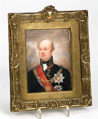
English School (late 19th century) Portrait of Field Marshal the 1st Viscount Beresford (1768-1854) watercolour on ivory 10.5cm x 8cm William Carr Beresford 1st Viscount joined the army in 1785 and distinguished himself in various campaigns before being appointed to the command of the Portuguese army in the Peninsular War as a Field Marshal. His most significant battle in independent command of an Anglo-Portuguese and Spanish army was at the Battle of Albuera where he defeated the army of Marshall Soult moving to relieve Badajoz in 1811. It was in this battle that BeresfordÕs most famous exploit took place whereby he unseated a French lancer by pulling him out of the saddle his sabre not drawn. In the Wellington administration of 1828-30 he served as Master-General of the Ordnance.
Kent. Milton (Thomas), A Geometrical Plan & West Elevation of his Majesty's Dockyard and Garrison at Sheerness, with the Ordnance, Wharf &c., 1755, uncoloured engraved plan with view of the dockyard above, highly decorative border incorporating title and key to principal buildings, split to lower central fold, fraying to margins not affecting printed image, approx. 510. x 690. mm, together with Rosenburg (C., engr.), Admiral Sir John Jervis off Cape St. Vincent, on the 14th of February 1797, pub. 29. May, 1837, hand coloured aquatint after Anthony Denny, some finger soiling and one closed tear to lower margin, image approx. 375. x 550. mm (2)
London. Plans of London relating to the building of New Government Offices and the Embankment, c.1830s 60s, mostly hand coloured to show location of proposed buildings, some fold creases and minor spotting, sizes vary but the largest measures approx. 680. x 1000. mm, together with one 5. feet to a mile Ordnance Survey sheet of the Notting Hill area, sheet VI. 67, 1894 96 (6)
London. Whitbread (J., pub.), Whitbread's New Plan of London Drawn from Authentic Surveys, 1857, hand coloured engraved folding map, a few minor fold tears, approx. 470. x 660. mm, orig. cloth boards with paper label to upper cover (rubbed and marked), together withWhitbread's Reduced Ordnance Map of London, 1881, hand coloured engraved folding map, laid onto linen, approx. 715. x 825. mm, contained in orig. green cloth gilt boards (2)
London. Ordnance Survey (pub.), Four one inch to one mile folding map sheets covering the London area, updated to 1901, hand coloured and sectionalised onto linen, some fold tears, each sheet approx. 680. x 995. mm, all in orig. limp dark red sheep boards with gilt lettering to upper covers 'S.W. Environs of London', 'N.W Environs of London', etc.' (rubbed) (4)
An 1885 pattern cavalry trooper’s sword, slightly curved fullered blade, 34½", by Weyersberg Kirschbaum & Co, Solingen, with various Ordnance stamps, plated at forte, regulation sheet steel hilt with pierced Maltese Cross, diced composition grips, back of guard stamped Y/LCT/115 (Leicestershire) in its steel scabbard stamped LCT/165. GC (shallow scabbard dent, some old varnish and black paint overall)

A good .303" Lee Speed bolt action military pattern rifle, 49¼" overall, barrel 30", number K37/17671; London Nitro Proved and also ordnance inspector’s mark at breech; the frame stamped "Lee Speed Patent, BSA Co", the bolt cover engraved "George Gibbs, 39 Corn Street, Bristol", with magazine cut off and long range sights including BSA aperture rearsight with Vernier scale; walnut fullstock, sling swivels. Near VGWO & C (the stock well repolished).

AN UNUSUAL 1930s HAND-MODELLED RELIEF MAP OF LAKE DISTRICT based on an Ordnance Survey Relief Tourist Map, One Inch to One Statute Mile, vertical scale of one eighteenth inch to 50 feet, signed in ink "Williamson 1936" lower right, the whole with inscribed fell, lake and village names plus naturalistic colouring, in a glazed pine case, 95cm x 75cm, (37.4in x 29.5in)
A .577/.450 MARTINI-HENRY CARBINE, action marked Witten, dated '1883', serial no. 33721, with 23in. sighted barrel with Henry patent rifling, action (defective) marked on the left side with maker's mark, and walnut three-quarter stock (some wear throughout), Ordnance proof marks of the Ishapore Factory, India. Please note that VAT at 5% is applicable to this Lot.
A .577 SNIDER-ENFIELD YEOMANRY CARBINE, converted from a muzzle-loading rifle, the lock dated '1865', with 19 1/8in. sighted barrel rifled with three grooves, mark 'II**' breech, BSA & Co. dated lock with 'VR' cypher, regulation half-stock reduced from full with Enfield stores mark on the butt, regulation brass mounts, and single iron barrel band, Ordnance inspection marks and Queen's proof marks; together with a .65 INDIAN-MADE TWO-BAND PERCUSSION CAVALRY CARBINE, second half of the 19th century, with 21in. smoothbore sighted barrel, three-quarter stock, iron saddle-bar, and stirrup ramrod. (2)

Eighteen military cap badges: RF metal badge, possibly fortress units, Maginot Line circa 1941; King's Royal Rifle Corps; Royal Marines; East Yorks; Lancasters; Queen's Rgt; Royal Engineers; Royal Artillery (three); Royal Army Ordnance Corps; Durham Light Infantry; ARP (three); ATS; Fide et Fiducia small badge; St. John's Ambulance (eighteen)
Handbook for Military Artificers, Prepared in the Ordnance College. London: H.M.S.O., 1899. 8th edn, 8vo, diagramatic illus., folding plates, blind-stamped scarlet cloth (bears ownership stamps for E"" Battery, Royal Horse Artillery); and Audsley, W. & G.. Guide to the Art of Illuminating. London: Rowney & Co., 1865. 11th edn, 8vo, frontis. and a further seven plates (of eight?), 41 pp. publisher's catalogue, blind-stamped crimson cloth (binding broken; sold with all faults), (2). """
Crimea & Engineering. Archive of maps, tinted lithographs and a book of original manuscript engineering notes and reports formerly belonging to Frederick King, Royal Engineer, all dating to the 1840s-50s and relating to the Crimean War and related engineering projects including the demolition of Sevastopol Docks, comprising Cooke, Brine, Fisher, Elpinstone, et al, Plan of Sevastopol and of the Attacks and Positions of the Allied Armies in 1854-5, lithographed at the Ordnance Map Office, Southampton, 1857, containing 7 sheets only (of 8), lacking sheet number 8, hand coloured in outline, some small marginal tears and a little toning, each sheet approx. 720 x 1070 mm, together with six other similarly sized plans of parts of Sevastopol and surrounding area, some published to accompany the Report on the Siege of Sevastopol, and three fine large tinted lithos. entitled 'Plan of the Docks of Sevastopol Previous to their Demolition', 'The Fortress and Field Defences of Kars, Representing the Action between the Russians under General Muraviev, and the Turks under General Williams on the 29th September, 1855', 'View of the Town and Defences of Kertch from the North', each pub. Topographical and Statistical Depot, War Department, 1855/56, each sheet approx. 690 x 1010 mm, plus four other smaller litho. plans relating to the Crimean War, and an ink engineering drawing entitled '8 Inch Iron Gomere Howitzer' by R.Nelson and E.Lloyd, showing a side elevation, approx. 430 x 640 mm, an ink engineering plan of Sevastopol Docks showing the positions for the placement of explosives, together with 122 loose pages of ink manuscript notes and reports in the hand of F.W. King including titles such as 'Report on the Defences of the River Thames', 'Description of the method Employed for Repairing a Chimney 120 feet high', 'General Notes for Determining the Charges of Military Mines', 'Rules for Making Shafts & Galleries in Rock or in Masonry Composed of Very Large Materials', 'Rules Applicable to the Demolition of Masonry by Blasting', etc. (-)
Antiquarian. Bartholomew (John), Geological Map of England & Wales Reduced Chiefly from the Ordnance and Geological Surveys, c.1890s, folding colour printed map, sectionalised onto linen, approx. 1060 x 900 mm, contained in orig. cloth slipcase with Stanford's paper label (sl. rubbed), together with Cooke (George Alexander), Topographical and Statistical Description of the County of Surrey, c.1817, four engraved views, folding engraved map, later paper wrappers, 12mo, and others including a book of John Leech etchings, an incomplete 1620s edition of the works of George Wither, three mid 18th century acts of parliament relating to Mutiny and Desertion from the army, etc (a carton)
Maps. Armstrong, Captain, & Son. A New Map of Ayrshire, comprehending Kyle, Cunningham & Carrick. The Scale one Inch to a Mile, 2 copies of the engraved map, each on six sheets, engraved by S. Pyle, hand-coloured in outline, 1775; Fleming, P. Plan of that part of the Town of Saltcoats and adjoining Lands of Town-head the property of Lord Montgomerie, engraved plan on two sheets joined, hand-coloured in outline, Glasgow, [no date], some soiling and staining; Nicholson, Peter Plan of the Town of Ardrossan proposed to be built on the Property of the right honourable the Earl of Eglinton, engraved map laid down on linen, Glasgow, J. Lumsden, [no date], slightly soiled; and a broadsheet "Proposals for Publishing, by Subscription, a Map of Airshire, from an actual survey" listing five subscribers including Mr Hamilton of Sundrum; and a folio of 1st edition Ordnance Survey maps of the Parish of Coylton (qty) Provenance: Mr Hamilton of Sundrum, name on list of subscribers for Ainslie's map of Airshire
-
12129 item(s)/page