We found 12129 price guide item(s) matching your search
There are 12129 lots that match your search criteria. Subscribe now to get instant access to the full price guide service.
Click here to subscribe- List
- Grid
-
12129 item(s)/page


Lot 668
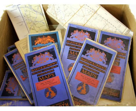
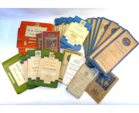
Ordnance Survey. Collection of 35 + 'vintage' regional folding maps comprising various formats and scales and a proportion of linen-backed examples. All University ex, lib. with stamps to outer covers which have moderate wear but remain sound. O/w generally clean and bright without fold tears etc

Lot 355
THE ASH JOY STICK FROM A GREAT WAR AEROPLANE, the R.E.8 two seater reconnaissance bi-plane as manufactured by The Coventry Ordnance Works Ltd. with their painted cypher and a SPAR from the same plane, 1.65m high, designed by John Kenworthy (see Duxfo rd Museum example - These are original spares, never having seen use)
Lot 108
Folding maps. Lynam (George), Map of the Parish of Stoke upon Trent in the County of Stafford from an Actual Survey, 1848, litho. map sectionalised and laid on linen, sparse contemp. hand colouring, some staining, some worming to image, 645 x 930mm, cloth endpapers, contained in contemp. slip case, worn and stained, with, Greenwood (C. & J.),Map of the County of Hereford from an Actual Survey, 1834,engraved map sectionalised and laid on linen, contemp. hand colouring, calligraphic cartouche, compass rose and table of explanation, b & w vignette of Hereford cathedral, slight offsetting, marbled endpapers, 590 x 700mm, with another ten folding maps, including examples by Ordnance Survey, Pratt and Bartholomew, plus an early 20th century jigsaw puzzle of central London, various sizes and condition (12)

Lot 461A
Johnstone (John) and W. & A.K. Johnston. - A group of 11 atlas sheets of European countries, lithographed maps with original hand-colouring, each c.510 x 605mm., all linen-backed with a central vertical fold, marginal finger-soiling, c.1850; with a Times Atlas map of the Baltic States and East Prussia, a smaller map of Belgium and 2 small folding Ordnance Survey maps of the areas around Canterbury and Rochester (15)


Lot 8
The Agricultural Statistics of Ireland for the Year 1857, 1858, 1859, 1860 & 1861 In One Binding. Dublin: Alex. Thom 1858-1863. Tables broken down into counties and poor law union districts. Contents include observations the District Inspectors of the Royal Irish Constabulary or Sergeants of the Metropolitan Police had to make on the probable cause as to good or bad yields of various crops in their district. Weather (meteorological observations) registered at the Ordnance Survey Office, Phoenix Park covered i.e. monthly barometer, temperature, rain, cloud, wind direction movements etc. Heavy vol., half calf with marbled boards.


Lot 258
Lots 258-265 are by Mary Langdon Edis, Lady Bennett (1881-1976) *Mary Langdon Edis, Lady Bennett (1881-1976)PORTRAIT OF A YOUNG WOMAN, HALF LENGTH, IN A BROWN DRESS AND CAMEO BROOCHSigned l.r., oil on canvas69 x 56cm This is a copy of the portrait by Alfred Stevens (1817-1875) of Mary Ann, wife of Leonard Collman, c.1854, in the Tate Gallery. *Artist`s Resale Right may apply to this lot.Mary Langdon Edis, Lady Bennett (1881-1976), married the architect Sir Thomas Penberthy Bennett (1887-1980) in 1916. He rose to prominence in 1940 as Minister for Bricks and, in 1941, became Director for Works, which involved the overseeing of hospitals, airfields, ordnance factories and prisoner of war camps. Mary Edis continued to paint and one of her portraits is in the National Portrait Gallery.

Lot 2720
American Civil War documents, mainly mid-1800s, including 1864 Confederate States of America $500 loan document complete with coupons, pencil written letters on Congress embossed paper, signed affidavits for monies from the Volunteer Aid Fund of the State Wisconsin in respect of wives and children, other bonds American Express company document 1878 Ordnance Office War Department Returns documents 1771 list of carpentry work for Rev. Mr. Fairfax (qty)


Lot 413
A Prussian model 1850 cavalry pistol, the 20cm sighted steel barrel with holster ring at the muzzle, with Prussian Ordnance marks and stamped 1851, the lock plate stamped with a crown over SULH V.C.S., the hinged cap guard and all metal mounts stamped with Prussian Ordnance marks, with brass fore-end tip, trigger guard with finger rest and stamped U.9.4.E 18, the brass butt cap with steel lanyard ring, 38cm long.

Lot 714
A GREAT WAR PAIR OF MEDALS TO PRIVATE G. SWEETMAN, ARMY SERVICE CORPS comprising the British War Medal 1914-20 and Victory Medal (both 32-SR-04227 Pte. G. Sweetman. A.S.C.), officially impressed, bar-mounted for wearing; together with a quantity of badges and other items, including an enamelled silver Gordon Highlanders sweetheart pin badge; Wiltshire Regiment pin badge; Royal Army Ordnance Corps pin badge; Royal Army Service Corps pin badge; Royal Engineers pin badge; Royal Engineers tie pin; and a 5th Light Horse Regiment (Australian Imperial Force) Christmas card, 1918.
Lot 413
A Prussian model 1850 cavalry pistol, the 20cm sighted steel barrel with holster ring at the muzzle, with Prussian Ordnance marks and stamped 1851, the lock plate stamped with a crown over SULH V.C.S., the hinged cap guard and all metal mounts stamped with Prussian Ordnance marks, with brass fore-end tip, trigger guard with finger rest and stamped U.9.4.E 18, the brass butt cap with steel lanyard ring, 38cm long.


Lot 321
A FINE FRENCH BRONZE MOUNTAIN HOWITZER," L`ACCUEIL", OBUSIER DE 12CM VALÉE, MODÈLE 1828, STRASBOURG, DATED 23 FEV. 1850, ON ITS ORIGINAL CARRIAGE with smooth-bore barrel cast with raised flat muzzle ring and base ring each grooved for sighting, cast with the individual name of the gun, "L`Accueil", on a stippled scroll towards the muzzle, with foundry mark between the trunnions, a cursive "C", the ends of the trunnions marked with the weight "101K" and "No.2" respectively, with the motto of the Second Republic, "Liberte Egalite Fraternite" surmounting the cipher of the Republic towards the base, recessed broad vent field, the base ring cast with a pair of stippled panels, one marked "Strasbourg" and other "23 Fev. 1850", with button cascable, and in fine condition throughout : on its original regulation grey-painted wooden carriage, "modèle de montagne", for pack transport, with two-piece trail bedded for a quoin only and with no provision for fitting a limber pintle, with lightly cambered iron-shod spoked wheels, together with its original elevating quoin and combined brush staff and ramrod stamped with the calibre designation "12" (two pins for a cap-square and other small carriage mounts missing) 95 cm; 37½ in barrel This gun was intended to fire a 4kg. explosive round. The Système Valée was developed by Sylvian-Charles, comte Valée, as an improvement on the Gribeauval ordnance system and was adopted in 1828. Further examples, each also individually named, are preserved in the Musée de l`Armée, Paris. Surviving carriages are understandably rare; this example, constructed for the Mountain Howitzer and distinct from a field carriage, is possibly now unique. Though then obsolete, the present gun and its carriage were almost certainly a trophy of the Franco-Prussian War of 1870.

Lot 99
A RARE DECORATED BRONZE AXLE BOSS FOR A GUN CARRIAGE, FROM ORDNANCE TAKEN AT THE FALL OF SERINGAPATAM, MYSORE, LATE 18TH CENTURY of heavy tubular construction, cast in relief in the form of a snarling tiger`s head, with punched and engraved bubri detail, on a base of conventional lotus leaves, slotted for a linch pin, and in untouched patinated condition 11.2 cm; 4 ½ in high Provenance Robin Wigington, Stratford-upon-Avon For other examples, mounted on carriages and from the same collection, see Sotheby`s 25 May 2005, lots 28 and 29.
Lot 348
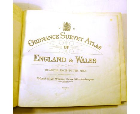
ORDNANCE SURVEY - Wales (part of), 4 sheets, nos. xxxvi/vii (pt. of Glamorgan), xli (pt. Camarthen) & xlii (pt. Brecknock & Monmouth), scale: one inch to mile, lithographed, folded & mounted on linen within cloth covers, opens to 64 x 95cms.; contained in original half morocco & marbled boards case, gilt-panelled spine. 1830-33.

Lot 3029
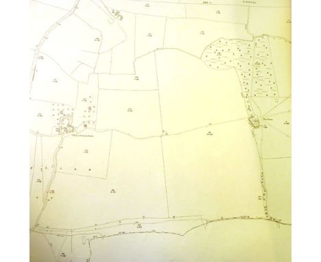
MAP, SOUTH COAST OF ENGLAND. - [ORDNANCE SURVEY. Five sheets from the survey, covering the South Coast from Hinton and the Isle of Wight to Folkestone. One sheet dated `1 June 1810`, the others with the imprint excised]. Engraved folding maps (four sheets 645 x 935mm, one sheet 645 x 760mm), all folded and backed onto linen. (Some splits and browning.) All folding within a single contemporary slipcase (slipcase worn). Provenance: The Library Collection of the Late W. Leslie Weller MBE, DL, FSA.
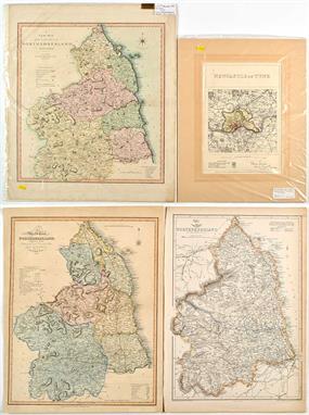
Lot 278
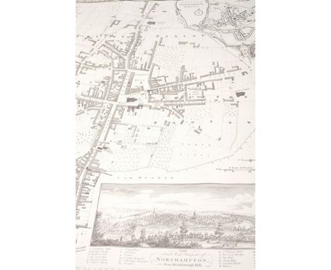
Charles Smith (1768-1854) "A NEW MAP OF THE COUNTY OF NORTHUMBERLAND DIVIDED INTO WARDS" c.1804 engraving with hand-colouring 61.5 x 51cms; 24 1/4 x 20in.; "NEWCASTLE ON TYNE ORDNANCE SURVEY" c.1868 engraving with hand-colouring 34.5 x 24cms; 13 1/2 x 9 1/2in.; together with two other antique maps of Northumberland, all unframed. (4)
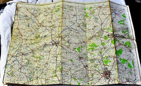
Lot 309
Ordnance Survey Road Map of Newcastle upon Tyne... Scale: half-inch to one mile, printed boards, [n.d.; Plan of Newcastle upon Tyne 1945, wrappers, folding maps and tables, Newcastle upon Tyne, [1945], together with 7 other books and maps similar, and 4 boxed sets of the Northumberland Census 1841-1871 on CD (13).


-
12129 item(s)/page