We found 23406 price guide item(s) matching your search
There are 23406 lots that match your search criteria. Subscribe now to get instant access to the full price guide service.
Click here to subscribe- List
- Grid
-
23406 item(s)/page

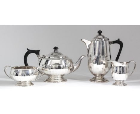
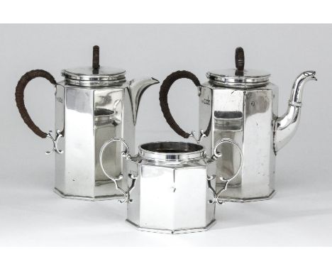
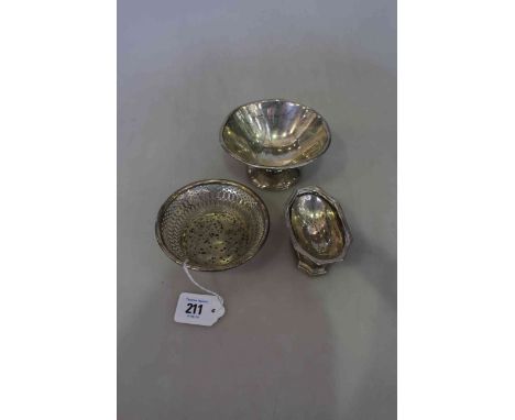
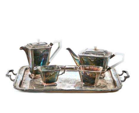
Lot 5
A George V silver circular four-piece tea service with moulded rims and part fluted bodies, scroll handles, on circular footrim, comprising - teapot with ebonised handle and finial, 6ins high, hot water pot with ebonised handle and finial, 8.75ins high, two-handled sugar basin and milk jug, by James Deakin & Sons, Sheffield 1931 (gross weight 69ozs)
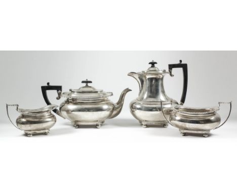
Lot 6
A George V silver rectangular four-piece tea service of bulbous form with gadroon, shell and scroll cast mounts, angular loop handles, on four ball feet, comprising - teapot, 6.25ins high, and hot water pot, 8.75ins high, with ebonised handles and finials, two-handled sugar basin and milk jug with leaf capped handles, by James Deakin & Sons, Sheffield 1931 and 1932 (gross weight 68ozs)
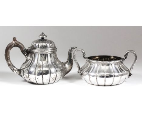
Lot 7
A late Victorian silver cylindrical and part reeded hot water pot with angular ebonised handle and reeded finial, on circular footrim, 7.75ins high, by Walker & Hall, Sheffield 1899 (gross weight 15.5ozs), and a late Victorian/Edward VII harlequin silver oval bachelor's tea service of part reeded form, comprising - tea pot with ebonised handle and finial, 5.5ins high, two-handled sugar basin and milk jug, by William Hutton & Sons Ltd, London 1897-1902 (gross weight 13ozs)
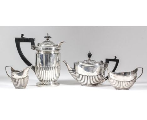
Lot 8
A George IV and William IV harlequin silver three-piece tea service, the circular squat lobed bodies with shaped and moulded rims, embossed and chased with leaf and floral ornament, leaf capped scroll handles, each on conforming four cast panel feet, comprising - teapot with flowerhead and leaf finial, 6.25ins high, two-handled sugar basin, London 1835, and milk jug, London 1829 (crested), all by Edward John & William Barnard (gross weight 48ozs)
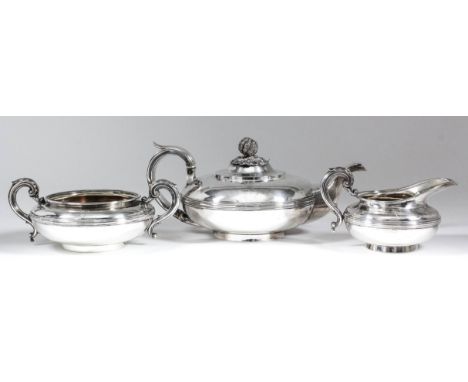
Lot 9
A George IV/William IV silver circular three-piece tea service of bulbous squat form with moulded rim and girdle to body, leaf capped high scroll handles, on circular footrims, comprising - teapot with berry and leaf pattern finial, 5ins high, two-handled sugar basin and milk jug, by Charles Fox II, London 1829 and 1830 (weight 43ozs - crested)
Lot 14
An Edward VII bachelors silver oval three-piece tea service with reeded rims and moulded bodies, comprising teapot with ebonised C-scroll handle and turned finial, 4.5ins high, two-handled sugar basin and milk jug, by Charles Stuart Harris, London 1903, and a small selection of silver and silvery metal ware (combined gross weight 20ozs)
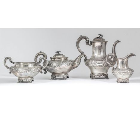
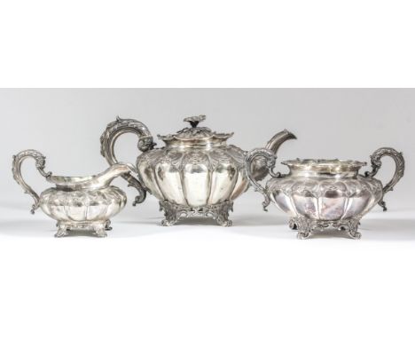
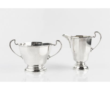
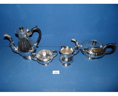
Lot 4
An early Victorian silver three-piece tea service, the circular squat bodies with moulded rims, embossed with scroll cartouche, floral and leaf ornament, leaf capped scroll handles, on four cast panel feet, comprising - teapot with flowerhead pattern finial, 6.25ins high, two-handled sugar basin and milk jug, by Richard Pearce & George Burrows, London 1840 (gross weight 42ozs - engraved with armorial, crest and presentation inscription dated 8th July 1840), and a similar coffee pot with cast flowerhead pattern finial, 10ins high, by William Hunter, London 1846 (gross weight 25ozs)
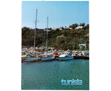
Lot 2802
Original vintage travel advertising poster published by the Tunisian National Tourist Office to promote Tunisia as a tourist destination, with a photograph depicting the Sidi Bou Said harbour with its small leisures boats and yachts. Tunisia, officially the Republic of Tunisia, is a country in the Maghreb region of North Africa, covering 163,610 square kilometres (63,170 square miles). Its northernmost point, Cape Angela, is the northernmost point on the African continent. It is bordered by Algeria to the west and southwest, Libya to the southeast, and the Mediterranean Sea to the north and east. Tunisia's population was 11.435 million in 2017. Tunisia's name is derived from its capital city, Tunis, which is located on its northeast coast. Geographically, Tunisia contains the eastern end of the Atlas Mountains, and the northern reaches of the Sahara desert. Much of the rest of the country's land is fertile soil. Its 1,300 kilometres (810 miles) of coastline include the African conjunction of the western and eastern parts of the Mediterranean Basin and, by means of the Sicilian Strait and Sardinian Channel, feature the African mainland's second and third nearest points to Europe after Gibraltar. Fair condition, tear in top margin. Country: Tunisia, year of printing: 1980s, designer: Unknown, size (cm): 63x48

Lot 2806
Original vintage travel advertising poster published by the Tunisian National Tourist Office to promote Tunisia as a tourist destination, with a photograph depicting a small street in a Tunisian village with a green door in the foreground and a blue house in the background. Tunisia, officially the Republic of Tunisia, is a country in the Maghreb region of North Africa, covering 163,610 square kilometres (63,170 square miles). Its northernmost point, Cape Angela, is the northernmost point on the African continent. It is bordered by Algeria to the west and southwest, Libya to the southeast, and the Mediterranean Sea to the north and east. Tunisia's population was 11.435 million in 2017. Tunisia's name is derived from its capital city, Tunis, which is located on its northeast coast. Geographically, Tunisia contains the eastern end of the Atlas Mountains, and the northern reaches of the Sahara desert. Much of the rest of the country's land is fertile soil. Its 1,300 kilometres (810 miles) of coastline include the African conjunction of the western and eastern parts of the Mediterranean Basin and, by means of the Sicilian Strait and Sardinian Channel, feature the African mainland's second and third nearest points to Europe after Gibraltar. Fair condition, paper loss, creases and tears in margins. Country: Tunisia, year of printing: 1980s, designer: Unknown, size (cm): 70x50
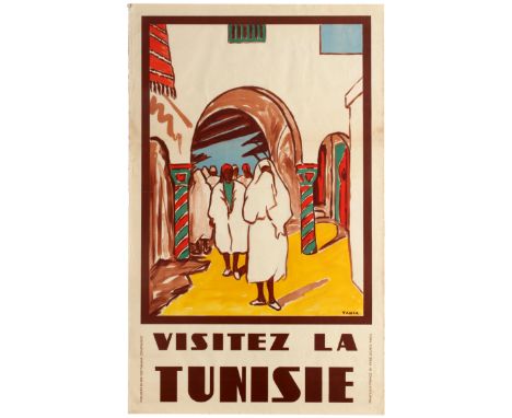
Lot 2500
Original vintage travel poster published by and for the Tunisian Government: Visit Tunisia (Visitez la Tunisie). Tunisia, officially the Republic of Tunisia, is a country in the Maghreb region of North Africa, covering 163,610 square kilometres (63,170 square miles). Its northernmost point, Cape Angela, is the northernmost point on the African continent. It is bordered by Algeria to the west and southwest, Libya to the southeast, and the Mediterranean Sea to the north and east. Tunisia's population was 11.435 million in 2017. Tunisia's name is derived from its capital city, Tunis, which is located on its northeast coast. Geographically, Tunisia contains the eastern end of the Atlas Mountains, and the northern reaches of the Sahara desert. Much of the rest of the country's land is fertile soil. Its 1,300 kilometres (810 miles) of coastline include the African conjunction of the western and eastern parts of the Mediterranean Basin and, by means of the Sicilian Strait and Sardinian Channel, feature the African mainland's second and third nearest points to Europe after Gibraltar. Yahia Turki, born Yahia Ben Mahmoud El Hajjem in 1903 in Istanbul, Turkey, died 1 March 1969, was a Tunisian painter described as the "father of Tunisian painting". Good condition, folded as issued, faint foxing, small tears and creases in margins. Country: UK, year of printing: 1950s, designer: Yahia Turki, size (cm): 99x62

Lot 2808
Original vintage travel advertising poster published by the Tunisian National Tourist Office to promote Tunisia as a tourist destination, with a photograph showing a white dome house seen through an arch door into a white wall. Tunisia, officially the Republic of Tunisia, is a country in the Maghreb region of North Africa, covering 163,610 square kilometres (63,170 square miles). Its northernmost point, Cape Angela, is the northernmost point on the African continent. It is bordered by Algeria to the west and southwest, Libya to the southeast, and the Mediterranean Sea to the north and east. Tunisia's population was 11.435 million in 2017. Tunisia's name is derived from its capital city, Tunis, which is located on its northeast coast. Geographically, Tunisia contains the eastern end of the Atlas Mountains, and the northern reaches of the Sahara desert. Much of the rest of the country's land is fertile soil. Its 1,300 kilometres (810 miles) of coastline include the African conjunction of the western and eastern parts of the Mediterranean Basin and, by means of the Sicilian Strait and Sardinian Channel, feature the African mainland's second and third nearest points to Europe after Gibraltar. Very good condition, faint creases in margins. Country: Tunisia, year of printing: 1980s, designer: Unknown, size (cm): 63x48

Lot 2804
Original vintage travel advertising poster published by the Tunisian National Tourist Office to promote Tunisia as a tourist destination, with a photograph depicting the Island of Jerba (or Djerba), best known for Mediterranean beaches, whitewashed desert towns and fishing ports. Tunisia, officially the Republic of Tunisia, is a country in the Maghreb region of North Africa, covering 163,610 square kilometres (63,170 square miles). Its northernmost point, Cape Angela, is the northernmost point on the African continent. It is bordered by Algeria to the west and southwest, Libya to the southeast, and the Mediterranean Sea to the north and east. Tunisia's population was 11.435 million in 2017. Tunisia's name is derived from its capital city, Tunis, which is located on its northeast coast. Geographically, Tunisia contains the eastern end of the Atlas Mountains, and the northern reaches of the Sahara desert. Much of the rest of the country's land is fertile soil. Its 1,300 kilometres (810 miles) of coastline include the African conjunction of the western and eastern parts of the Mediterranean Basin and, by means of the Sicilian Strait and Sardinian Channel, feature the African mainland's second and third nearest points to Europe after Gibraltar. Good condition, faint creases in margins. Country: Tunisia, year of printing: 1980s, designer: Unknown, size (cm): 63x48
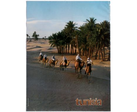
Lot 2801
Original vintage travel advertising poster published by the Tunisian National Tourist Office to promote Tunisia as a tourist destination, with a photograph depicting a caravan of camels walking across the desert with palm trees in the background. Tunisia, officially the Republic of Tunisia, is a country in the Maghreb region of North Africa, covering 163,610 square kilometres (63,170 square miles). Its northernmost point, Cape Angela, is the northernmost point on the African continent. It is bordered by Algeria to the west and southwest, Libya to the southeast, and the Mediterranean Sea to the north and east. Tunisia's population was 11.435 million in 2017. Tunisia's name is derived from its capital city, Tunis, which is located on its northeast coast. Geographically, Tunisia contains the eastern end of the Atlas Mountains, and the northern reaches of the Sahara desert. Much of the rest of the country's land is fertile soil. Its 1,300 kilometres (810 miles) of coastline include the African conjunction of the western and eastern parts of the Mediterranean Basin and, by means of the Sicilian Strait and Sardinian Channel, feature the African mainland's second and third nearest points to Europe after Gibraltar. Fair condition, tears and creases in margins. Country: Tunisia, year of printing: 1980s, designer: Unknown, size (cm): 63x48

Lot 2807
Original vintage travel advertising poster published by the Tunisian National Tourist Office to promote Tunisia as a tourist destination, with a photograph depicting a blue window protected by a blue decorative iron grill and a wooden screen. Tunisia, officially the Republic of Tunisia, is a country in the Maghreb region of North Africa, covering 163,610 square kilometres (63,170 square miles). Its northernmost point, Cape Angela, is the northernmost point on the African continent. It is bordered by Algeria to the west and southwest, Libya to the southeast, and the Mediterranean Sea to the north and east. Tunisia's population was 11.435 million in 2017. Tunisia's name is derived from its capital city, Tunis, which is located on its northeast coast. Geographically, Tunisia contains the eastern end of the Atlas Mountains, and the northern reaches of the Sahara desert. Much of the rest of the country's land is fertile soil. Its 1,300 kilometres (810 miles) of coastline include the African conjunction of the western and eastern parts of the Mediterranean Basin and, by means of the Sicilian Strait and Sardinian Channel, feature the African mainland's second and third nearest points to Europe after Gibraltar. Good condition, small creases and tears in margins. Country: Tunisia, year of printing: 1980s, designer: Unknown, size (cm): 63x48
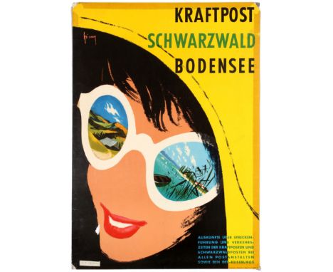
Lot 2609
Original vintage travel poster published by the German Federal Post Office to promote its passengers transport services, the famous yellow Kraftpost bues, across the south west region of the Black Forest and the Lake Constance (text reads: Krafpost Schwarzwald Bodensee) featuring a vivid and colourful artwork depicting the portrait of a young woman with views of the Black Forest and the Lake Constance reflecting into her sunglasses. Lake Constance (German: Bodensee) is a lake on the Rhine at the northern foot of the Alps, and consists of three bodies of water: the Obersee or Upper Lake Constance, the Untersee or Lower Lake Constance, and a connecting stretch of the Rhine, called the Seerhein. These waterbodies lie within the Lake Constance Basin (Bodenseebecken), which is part of the Alpine Foreland and through which the Rhine flows. The lake is situated in Germany, Switzerland, and Austria. Its shorelines lie in the German states of Bavaria and Baden-Württemberg, the Swiss cantons of St. Gallen, Thurgau, and Schaffhausen, and the Austrian state of Vorarlberg. The Rhine flows into the lake from the south, with its original course forming the Austro-Swiss border, and has its outflow on the "Lower Lake" where — except for Schaffhausen — it forms the German-Swiss border until the city of Basel. The most populous cities on the lake are Constance (German: Konstanz), Friedrichshafen, Radolfzell am Bodensee, Bregenz, and Lindau (Bodensee). The largest islands are Reichenau in the Lower Lake, and Lindau and Mainau in the Upper Lake. Poor condition, tape stains, edges reinforced with tape on reverse, paper losses in corners, cracks and tears. Country: Germany, year of printing: 1960s, designer: Friumy?, size (cm): 84x59

Lot 2803
Original vintage travel advertising poster published by the Tunisian National Tourist Office to promote Tunisia as a tourist destination, with a photograph depicting the small desert town of Matmata, best known for its underground cave or troglodyte structures, which house some of the local Berber population. Tunisia, officially the Republic of Tunisia, is a country in the Maghreb region of North Africa, covering 163,610 square kilometres (63,170 square miles). Its northernmost point, Cape Angela, is the northernmost point on the African continent. It is bordered by Algeria to the west and southwest, Libya to the southeast, and the Mediterranean Sea to the north and east. Tunisia's population was 11.435 million in 2017. Tunisia's name is derived from its capital city, Tunis, which is located on its northeast coast. Geographically, Tunisia contains the eastern end of the Atlas Mountains, and the northern reaches of the Sahara desert. Much of the rest of the country's land is fertile soil. Its 1,300 kilometres (810 miles) of coastline include the African conjunction of the western and eastern parts of the Mediterranean Basin and, by means of the Sicilian Strait and Sardinian Channel, feature the African mainland's second and third nearest points to Europe after Gibraltar. Fair condition, tears and creases in top right corner. Country: Tunisia, year of printing: 1980s, designer: Unknown, size (cm): 63x48
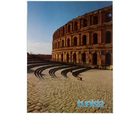
Lot 2805
Original vintage travel advertising poster published by the Tunisian National Tourist Office to promote Tunisia as a tourist destination, with a photograph depicting the world famous 'Amphitheatre of El Jem'. The town of El Jem is home to some of the most impressive Roman remains in Africa. Tunisia, officially the Republic of Tunisia, is a country in the Maghreb region of North Africa, covering 163,610 square kilometres (63,170 square miles). Its northernmost point, Cape Angela, is the northernmost point on the African continent. It is bordered by Algeria to the west and southwest, Libya to the southeast, and the Mediterranean Sea to the north and east. Tunisia's population was 11.435 million in 2017. Tunisia's name is derived from its capital city, Tunis, which is located on its northeast coast. Geographically, Tunisia contains the eastern end of the Atlas Mountains, and the northern reaches of the Sahara desert. Much of the rest of the country's land is fertile soil. Its 1,300 kilometres (810 miles) of coastline include the African conjunction of the western and eastern parts of the Mediterranean Basin and, by means of the Sicilian Strait and Sardinian Channel, feature the African mainland's second and third nearest points to Europe after Gibraltar. Good condition, faint creases and tears in margins. Country: Tunisia, year of printing: 1980s, designer: Unknown, size (cm): 63x48
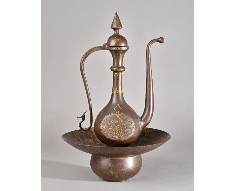
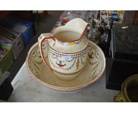
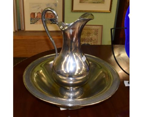
Lot 1965
A Qajar gold-damascened ewer and basin, 19th century, the ewer on spreading foot, the bulbous body damascened each side with script, beneath a slender neck and hinged cover, the basin of squat form with flared decorated with foliate medallions, with pierced insert, ewer 41cm. high, basin 31cm. diameter.Provenance: Christie's London, 17th April, 2007, lot 249. Illustrated.
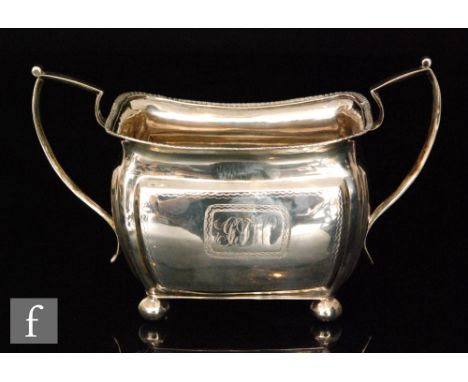
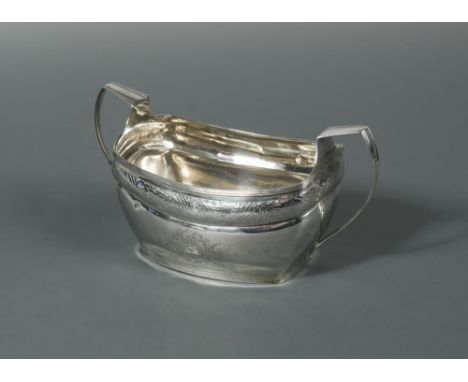
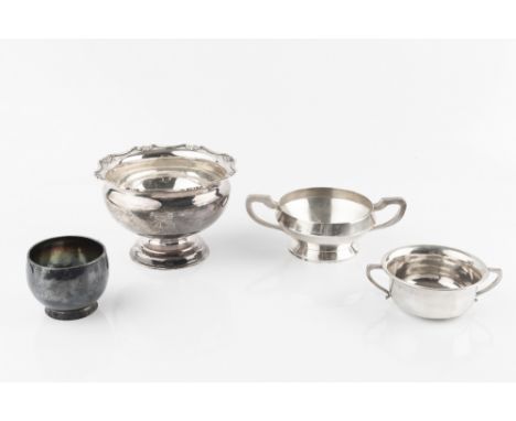
Lot 455
Dublin - A William lV silver sugar basin, maker's mark rubbed, probably 1830, of rectangular form with an upper band of engraved chequerboard and foliate design between bands of bright cut dots, the lower section with two wreath edged cartouches, one crested, the other vacant, the bottom section with three bands of bright cut engraving, reeded rim and two applied handles, 7.8ozt 10 x 19 x 10cm (4 x 7 x 4in)
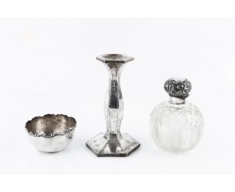
Lot 500
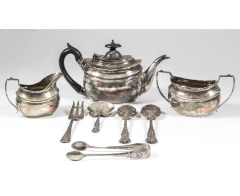
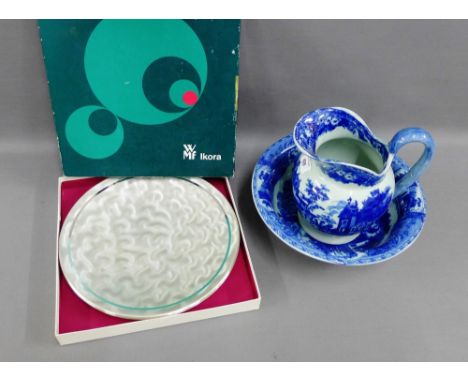
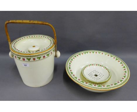
A COLLECTION OF SILVER, comprising a candlestick, of shaped hexagonal form, 18cm high; a cut glass globular scent bottle with silver mounts, Birmingham 1897; a sugar basin; two napkin rings; a cruet set, cased; an egg cup and spoon, cased; a George III Old English pattern tablespoon, by Thomas Watson, Newcastle 1815, and other small items (qty)
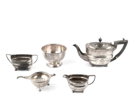
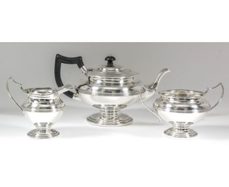
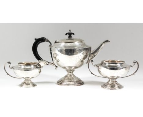
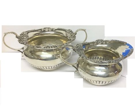
Lot 533
A LATE VICTORIAN SILVER BACHELOR'S THREE PIECE TEA SERVICE, of shaped oval design, the teapot with ebonised handle and knop, by Fordham & Faulkener, Sheffield 1900, teapot 12cm high; and other silver to include a pedestal sugar basin, Sheffield 1896, a tea strainer with bowl, and other small items, approximately 22oz all in (qty)
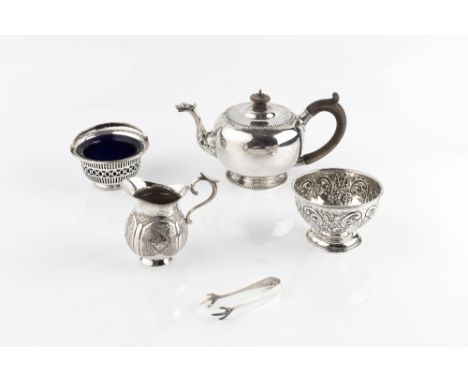
Lot 581
A SILVER BACHELOR'S TEAPOT, with gadrooned border, mask and foliate spout, and wooden handle and knop, by Nayler Bros, London 1917, 12cm high, 14oz all in, together with an Edwardian repoussé decorated pedestal sugar basin, Birmingham 1906, a further swing handled sugar basin, with blue glass liner, stamped Sterling, a pair of silver sugar tongs, and a plated cream jug (5)
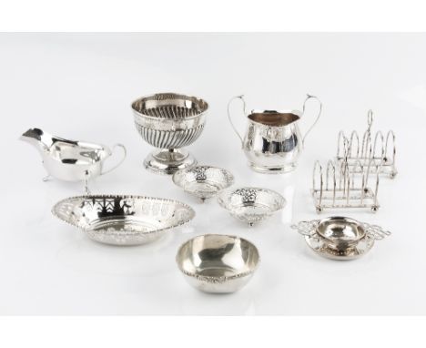
Lot 584
A GROUP OF SILVER, comprising a pair of Edwardian five bar toast racks by William Hutton & Sons Ltd, London 1903, a pedestal half lobed sugar basin, Birmingham 1915, a pierce decorated oval dish, Sheffield 1932, a pair of pierce decorated sweetmeat dishes, a turn handled sugar basin, a sauce boat, a small dish, three napkin rings, and other oddments, 28oz weighable (qty)
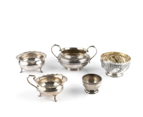
Lot 597
AN EARLY VICTORIAN SILVER TWIN HANDLED SUCRIER, of girdled form and engraved with scrolling foliage, by Joseph Angell I & Joseph Angell II, London 1841, 10.5cm high, 10 oz; a Victorian pedestal sugar basin, repoussé decorated with flowers by Josiah Williams & Co, London 1893, 6.5oz; a silver milk jug and matching sugar basin; and a small plain sugar basin, 14.5oz (5)
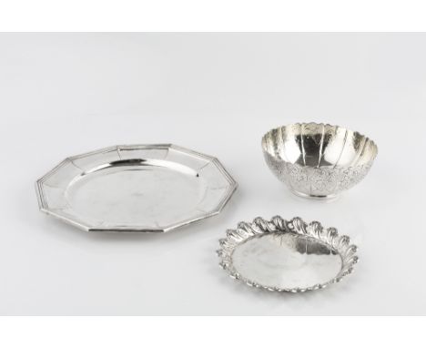
Lot 621
AN EARLY VICTORIAN SILVER SUGAR BASIN, with shaped border, the panelled sides chased with flowers and scrolls by John Wilmin Figg, London 1845, 14cm diameter, 7oz; together with an Italian faceted plate with reeded border, 23cm; and a German small dish with pierced and embossed border, both stamped 800 (3)

-
23406 item(s)/page