

HAMILTON EMMA: (1765-1815) Wife of Sir William Hamilton and mistress of Lord Nelson. Good D.S., Emma Hamilton, twice, one page, folio, n.p. (London), 14th May 1811. The partially printed document is addressed to Thomas Dixon and William Leake, Attorneys of His Majesty`s Court of Kings Bench at Westminster, and is a Warrant of Attorney authorising them to appear on Hamilton`s behalf in an action for a debt of £600. Signed by Hamilton at the foot alongside a red wax seal and again signed in the left margin beneath the manuscript text `This Warrant of Attorney is given to secure the payment of two Bills of Exchange for One hundred and Fifty pounds each dated the thirteenth and fourteenth days of May instant drawn by Carlo Revedino upon the said Lady Hamilton at two months after date.` With blank integral leaf. VG Two years after the present document was signed, in the summer of 1813, Emma Hamilton was arrested for debt and consigned to the Kings Bench prison where she remained for a year with her daughter Horatia.
We found 33306 price guide item(s) matching your search
There are 33306 lots that match your search criteria. Subscribe now to get instant access to the full price guide service.
Click here to subscribe- List
- Grid
-
33306 item(s)/page

NELSON HORATIA: (1801-1881) Illegitimate daughter of Horatio Nelson and Emma Hamilton. Rare D.S., H N Ward, one page, 4to, n.p., 24th August 1865. The attractively penned manuscript document is a receipt for £75.16.10 from Frances Elizabeth, Dowager Countess Nelson, `sole surviving Trustee of the Settlement executed on my marriage with my late husband The Reverend Philip Ward deceased….being the proceeds of sale of £85.18.9 Consols sold at my request and representing my 1/8th part of the 1/8th Share of my late daughter Caroline Mary Ward in £5500 Consols…` Signed by Nelson at the foot, her surname across an affixed pale violet One Penny Inland Revenue stamp. A couple of neat tears to the folds have been repaired to the verso, otherwise about VG Horatia Nelson had married Rev. Philip Ward on 19th February 1822 and together they had ten children, Caroline Mary Ward being their youngest, born in January 1836.
![[NELSON HORATIO]: (1758-1805) British Admiral during the Napoleonic Wars, the victor of the Battle of Trafalgar, 1805. A larg](http://lot-images.atgmedia.com/SR/35396/2864379/991-201262616494_468x382.jpg)
[NELSON HORATIO]: (1758-1805) British Admiral during the Napoleonic Wars, the victor of the Battle of Trafalgar, 1805. A large plain white silk handkerchief, measuring 27.5 x 25.5, apparently belonging to Nelson, accompanied by a holograph letter of provenance signed by a Clarissa Catherine Board, one page, oblong 8vo, Kilburn, London, 1889, stating, in full, `This handkerchief formerly belonged to Lord Nelson & was given by John Braham to John Dickinson, Solicitor of New Broad Street, City, in the year 1824. John Braham (Singer) married Miss Bolton & her Brother Dr George Buckley Bolton of St. James`s was married to Miss Clarissa Verbeke, my Aunt & Sister to my Mother Catherine Dickinson` and further stating, to the verso, `The Boltons were related to Lord Nelson. I will write this out again more fully`. Together with a second holograph statement in the hand of Clarissa Catherine Board, one page, oblong 8vo, stating, in full, `(My Mothers Sister) My Aunt, Clarissa Verbeke married Mr George Buckley Bolton, Surgeon, Uncle of the late Countess Francis Waldegrave & Brother to the Countess of Waldegrave`s Mother.` Also including a contemporary manuscript copy of a certificate of marriage between John Dickinson and Catherine Verbeke in the Parish of Richmond, Surrey, 1st July 1853, the verso annotated in an unidentified hand Lord Nelson`s handkerchief. The handkerchief has a few dark bloodstains and a couple of light spots of foxing, some very small holes and a little fraying to one edge. The accompanying documents have light overall age wear and minor faults, G, 4 John Braham (c.1774-1856) English Tenor, one of Europe`s leading opera singers. It seems quite possible that Braham could have acquired Nelson`s handkerchief; it is recorded that Nelson was present at a performance by the singer at Livorno in 1799. Furthermore, at this time, Braham was supported by the Goldsmid family, wealthy financiers, whose neighbour and occasional guest at soirées (where Braham frequently provided the entertainment) was Lord Nelson. Indeed, Nelson`s heroic fate was later to prompt Braham`s greatest song-writing success, The Death of Nelson. It first appeared in the opera The Americans, at the Lyceum Theatre in 1811. Lady Hamilton, who was in a private box for the performance, was reported to have been so overcome that she suffered a fit of hysterics and had to leave the theatre.

NELSON HORATIO: (1758-1805) British Admiral during the Napoleonic Wars, the victor of the Battle of Trafalgar, 1805. A very fine, rare D.S., Nelson & Bronte, one page, folio, given on board HMS Victory, 10th June 1804. The attractively penned manuscript document is addressed to Sir Richard Bickerton, Rear Admiral of the White, on board the Royal Sovereign, and is headed Order of Battle and of Sailing. The document outlines Nelson’s plans for the formation of ships for the Blockade of Toulon, listing eleven vessels including the Victory, Superb, Renown, Triumph and Bickerton’s own Royal Sovereign, along with the names of the Captains of each ship including Nelson himself. The list of ships are split into three sections, Van Squadron, Centre Squadron and Rear Squadron. Boldly signed by Nelson at the foot. With blank integral leaf. A later, small red ink stamp appears in the upper right corner. The text is illegible although is presumably that of a collector. Some slight discoloration to the extreme edges of the document, caused by previous framing, not affecting the text or signature. VG

PEPYS SAMUEL: (1633-1703) English Naval Administrator and Diarist. L.S., S Pepys, one page, folio, Navy Office, 9th February 1668, to Mr. Shippwet, Ch. Cherq. & Storekeep at Chatham. The manuscript letter seeks clarification of the claims made by a labourer working for the King and states, in full, `Wee have seene your certification at yr. bottome of a peticon of Danl. Bowtroolls the Kings MarCaulker at Chatham, and having good reason to doubt that his pretence to yr. Joyners house is grounded upon a designe of yr. late Joyners to prejudice him that who succeede him. Wee desire you to informe us what you can learne touching yr. grounds of yr. said Joyner no earlyer declaring yr. Caulkers right to his house.` Countersigned by three Commissioners of the Navy, William Brouncker, 2nd Viscount Brouncker (1620-1684) English Mathematician, first President of the Royal Society, Sir John Mennes (1599-1671) English Vice Admiral, Controller of the Navy and Colonel Thomas Middleton (d.1672) Surveyor of the Navy 1667-72. Some very light, minor overall foxing and some slight chipping to the left edge. About VG The letter dates from the period of Pepys` Diaries and as such is scarce and desirable. Indeed, Pepys makes references to the three countersignatories in his diaries, expressing his disgust at Brouncker for living out of wedlock with the actress Abigail Williams and describing Mennes as being `ill at ease` in his role as a Commissioner of the Navy.
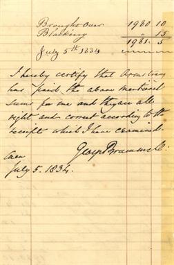
BRUMMELL GEORGE: (1778-1840) English Dandy, known as ‘Beau Brummell’. Rare D.S., George Brummell, two pages, 8vo, Caen, 5th July 1834. The manuscript document comprises a set of accounts from January-July 1834 listing various payments including 12 pairs of silk socks, 4 pairs of drawers, various letters to England, cash and the services of a washer woman, totalling £1981.5. At the conclusion of the accounts Brummell has certified the figures, writing, in full, ‘I hereby certify that Armstrong has paid the above mentioned sums for me and they are all right and correct according to the receipts which I have examined’, adding his signature and date beneath. A light band of discoloration appears to the right edge of the second page, only very slightly touching the conclusion of the signature and a few letters of text. Otherwise VG Brummell was a popular figure in Caen, noted for the way he would tiptoe across the cobbles to avoid getting dirt on his boots. Here he struck up a friendship with the grocer and wine merchant Charles Armstrong, who also cashed bills and money orders, and is referred to in the present document.

BRUMMELL GEORGE: (1778-1840) English Dandy, known as ‘Beau Brummell’. Rare D.S., George Brummell, four pages, 8vo, n.p. (Caen), n.d. (1834). The manuscript document comprises a set of accounts from July 1833-January 1834 listing various payments to a number of individuals and also for a snuff box, laundry, groceries & wine, shirts, letters to England, and a washer woman etc., totalling £12705.5. At the conclusion of the accounts Brummell has certified the figures, writing, in full, ‘These are the bills that Armstrong has paid for me since his return from England in July last’, adding his signature beneath. Some very light, minor age toning and a small tear to the base of one page, not affecting the signature. About VG Brummell was a popular figure in Caen, noted for the way he would tiptoe across the cobbles to avoid getting dirt on his boots. Here he struck up a friendship with the grocer and wine merchant Charles Armstrong, who also cashed bills and money orders, and is referred to in the present document.

ILLUMINATED MANUSCRIPT BOOK. – A.P. (calligrapher). The Shunammite and Her Son. [N.p.: n.d. but dedication dated ‘April 5 1854’]. 31pp. illuminated manuscript on vellum leaves, folio (223 x 156 mm.) (Slightly affected by damp.) Contemporary green morocco elaborately tooled in gilt, gilt turn-ins, silk endpapers, g.e. (extremities slightly rubbed). Provenance: ‘E.J.P.’ (presentation inscription verso of title). Note: Part of the IVth chapter of the Second Book of Kings.
![[HOLINSHED, Ralph. The Chronicles of England from the First Beginning. N.p.: n.d. but 1577.] 2 vols., 8vo (278 x 183mm.) Nume](http://lot-images.atgmedia.com/SR/10123/2857428/3128-201274105025_468x382.jpg)
[HOLINSHED, Ralph. The Chronicles of England from the First Beginning. N.p.: n.d. but 1577.] 2 vols., 8vo (278 x 183mm.) Numerous woodcuts, including a double-page map of Edinburgh. (Double-page map shaved and torn with some loss, some other shaving with loss to some headings, etc., lacking title-pages but replaced with a letterpress title contained in a woodcut border, pp.291-305 supplied from a smaller copy, pp. 1247-1249 and 1389-1390 replaced in manuscript by a 19th Century hand.) Early 20th Century half-calf (spines slightly faded and rubbed, endpapers replaced). Provenance: Charles Arthur Wynne Finch (armorial bookplates to front pastedowns). Note: lacking parts on Scotland and Ireland in vol. I, see Lowndes.

![[LANGLAND, William. The Vision of Pierce Plowman. London: Roberte Crowley, 1550.] 4to (198 x 133mm.) (Lacking all leaves, inc](http://lot-images.atgmedia.com/SR/10123/2857428/3206-20127515658_468x382.jpg)

[ERASMUS, Desiderius. The Praise of Folie. Moriae Encomium, a Book made in Latyne by that Great Clerke Erasmus Roterodame, englisshed by Sir Thomas Chaloner, second edition. London: ?1557.] 4to (182 x 134mm.) Extra-illustrated with two near contemporary woodcuts of fools or jesters. (Lacking title-page, replaced in manuscript with a woodcut surround supplied from a contemporary book, lacking colophon leaf, occasional soiling or browning.) Old calf (worn, covers detached, front-free endpaper now loosely inserted). Note: as this work lacks the title-page the catchword ‘him’ on B1 has indicated that this is the second edition, despite the manuscript title stating ‘By Thomas Berthelet 1549’.

R. Luddecke, Map of Africa, in six sections, 1890, 99 x 86cm, in cloth covers; a manuscript folding plan on glazed cotton of `Kawkareik Subdivision` [South Burma], by W.C. Johnson (SLR) 1902, 180 x 109cm; a map of Dominica, 1914, 102 x 69cm; a Philip`s County atlas 1902; Army List for 1916; few others
![`Kyd` [Joseph Clayton Clarke] Cyrus Cuneo Bantam Esq. from Pickwick Papers, watercolour, 9 x 9cm; a late Victorian caricature](http://lot-images.atgmedia.com/SR/10091/2851001/301-20126289530_468x382.jpg)
`Kyd` [Joseph Clayton Clarke] Cyrus Cuneo Bantam Esq. from Pickwick Papers, watercolour, 9 x 9cm; a late Victorian caricature of a gentleman in striped trousers, signed indistinctly, 17 x 9cm; a 16pp manuscript book of verses illustrated with flowers, circa 1920; and an autograph sketch book circa 1890, with few drawings (4)

Literature, various KNIGHT (R.P) An Analytical Enquiry into the Principles of Taste, 4th ed, 1808, 8vo, worn half binding; CALLOT (Jaques) De Droeve Ellendigheden Van Den O Orloogh, mounted series of engravings, numbered 1-18, trimmed, morocco backed boards; COWELL (J) The Interpreter or Booke Containing the signification of Words, Cambridge 1607, double column, a few pages in contemporary manuscript facsimile, staining, detached limp vellum, other mainly 19th century, in varying condition, some backed or rebound etc. (2 boxes)

Sussex - Herstmonceaux manuscript inventory of the goods and chattels of John Hay of Herstomonceaux written on a long strip of vellum approx 4ft x 6ins in fine bright condition. A particularly interesting document with considerable listing of Hay`s goods. A note to verso dates this to April 24th 1611 being a copy of the original inventory made on October 17th 1605. Documents relating to John Hay (or Haye) are in the East Sussex Record Office.

Suffragettes - calligraphic manuscript a fine calligraphic presentation manuscript presented by the Bolton Women`s Local Government Association to Mary Ann Howard on her retirement from her position as Poor Law Guardian. Howard was a locally based Suffragette. Ms written on 4pp of parchment 8vo size formed into a booklet with paper covers and housed in a custom made fabric wallet with Howard`s initials embroidered on front cover. The calligraphic script is executed in black with embellishments in red and gold.

Diary - manuscript - 18th/19th c a fine `memorandum` book kept by Thomas Adams an attorney from Northumberland chronicling his visits to London closely written on approx 72pp 8vo with vellum covers. Together with a bundle of documents providing further information on his various visits to the Capital. The book and supportive documents provides a fascinating insight into the life of an attorney at this time and of London life generally. He lists all the people he had to visit while on business in London makes observations about the coach journeys inns where he stays costs etc.


LAWRENCE D.H. (1885-1930). A Collection of Four Novels. Sons and Lovers. New York: The Modern Library, 1922. With an introduction by John Macy. 183 x 124 x 25mm. Dust jacket with moderate wear and loss to edges. Green cloth cover. Overall fair condition. The Virgin and the Gypsy. New York: Alfred A Knopf, 1930. Posthumous Novel, published November, 1930; First and second printings before publication; third printing November 1930. 196 x 133 x 26mm. Dust jacket with moderate wearing, loses along edges. Light brown cloth cover. Women in Love. New York: Modern Library, [1922]. 182 x 125 x 28mm. Dust jacket in fair condition with minor loss to edges and fading over brown cloth cover. Overall good condition. Lady Chatterly`s Lover. New York: Grove Press Inc., [1928-1959]. This edition is the third manuscript version, first published by Giuseppe Orioli, Florence, 1928. 206 x 142 x 37mm. Dust jacket with some sunning and wear over cloth boards. Overall good condition. Minimum shipping costs apply, please request quote before bidding.

Wainright, Alfred (1907-1991), autograph manuscript notebook, as used in the production of the author`s early work, containing the distinctive and meticulous pencil hand, sketches and maps reproduced in the Pictorial Guide to the Lakeland Fells published between 1955 and 1966, including attention to final publication such as page layout and font, the notebook comes together with approximately 24 Ordinance Survey maps hand annotated by Wainwright and drawn upon, plus a further 27 as used by Cyril Moore, the author`s assistant and trail walker


Title Pages (The Bible That Is, the Holy Scriptures Contained in the Old & New Testament), ca. 1610. 8 x 11.8”. (HC) This title page is from an early 17th-century edition of the Geneva Bible, popularly known as the Breeches Bible, Elizabethan Family Bible, or Pilgrim’s Bible. The Geneva Bible was first published in 1560 in Switzerland by refugees who fled England during the reign of the Roman Catholic Queen BloodyMary. Publication returned to England when Protestant-friendly Queen Elizabeth took the throne. It is one of the most significant Protestant translations of Scripture prior to the King James. This title page is from an edition published by Robert Barker, and features two pillars decorated by 24 medallions representing various personages in the bible. The pillars are surrounded by grapevines and biblical scenes, including Adam and Eve in the Garden of Eden, and Moses and the Ten Commandments. Watermarked paper with some minor creasing in corners. Remargined at right and bottom with small loss of image at bottom. There is faint manuscript writing in title cartouche including the date 1611. (B)
![World (Designatio Orbis Christiani), Mercator/Hondius, Atlas Minor, Amsterdam, [1607]. 7.5 x 5.8”. (HC) This is one of](http://lot-images.atgmedia.com/SR/36385/2862480/11-2012510161337_468x382.jpg)
World (Designatio Orbis Christiani), Mercator/Hondius, Atlas Minor, Amsterdam, [1607]. 7.5 x 5.8”. (HC) This is one of the first thematic maps, and it is the second world map in the Mercator-Hondius Atlas Minor. It is on a planispherical projection and uses symbols (identified in the key at bottom) to designate those areas of the world that are Christian (cross), Muslim (crescent), and idolaters (arrow). This is from the first edition, with Latin text on verso. Ref: Shirley no.260. There are a few faint spots and the map has been professionally remargined at top right with a small amount of neatline in facsimile. Cardinal directions written in manuscript ink in blank margins. (+B)

Ancient World (Tabula Itineraria ex Illustri Peutingerorum Bibliotheca…), Jansson, Amsterdam, ca. 1650. 159.3 x 7.3”. (HC) This impressive long map is the famous Peutinger Table, or a Roman road map of the world. The original parchment document was found by Konrad Celtes in a library in Augsburg, came into the hands of Konrad Peutinger and later went to his relative Mark Welser who was the first to publish a copy of it in 1591 at Aldus Manutius in Venice. This map, based on the original manuscript, was first popularized by Ortelius in 1598 and became an important part of his great historical atlas. Jansson`s version is nearly identical to that of Ortelius. This decorative strip map depicts the imperial roads and posts within the Roman Empire throughout Europe, North Africa and Asia as far as Toprobana (Sri Lanka). Printed on 8 sheets, now joined. Ref: Shirley no.393. Issued folding, with some minor fold separations that have been archivally repaired. (A)

North America (A New Map of the North Parts of America Claimed by France under ye Names of Louisiana, Mississipi, Canada and New France with ye Adjoyning Territories of England and Spain), Moll, London, 1720. 39.8 x 24.3”. (HC) This large format map of North America is one of the most accurate English maps of the early 18th century. It is based upon Delisle`s influential map of 1718 and refutes the French territorial claims made on that map. The map shows French claims covering the Midwest and Mississippi valley. Moll notes the encroachment of the English claims in the east with a dotted line roughly following the Allegheny Mountains, showing the French interpretation of the evolving boundaries. Dotted lines also note the disputed boundaries of Carolina. These rival claims eventually culminated in the French and Indian War. According to Cumming, Moll’s map presents new information in the Southeast including trading routes, Indian tribes and villages, and French, English and Spanish forts and settlements. This information, which does not appear on any other printed map, was purportedly obtained from a manuscript map in the Public Record Office in London. In the west, California is shown as an island and the entire west coast south of Lahontan`s Limit is marked as "Parts Unknown." While there is little inland detail, the river system is well documented, including an area of Texas where many French explorers` routes are shown. The map is filled with interesting notations noting the quality of the land, the variety of Indian nations, the Country full of Beeves (Texan longhorn cattle) and a fascinating account of an Indian slave-hunting expedition in Florida. There are three insets including The Harbour at Annapolis Royal, A Map of the Mississippi and Mobile Rivers &c., and The Indian Fort Sasquehanok. It is further decorated by an elegant title cartouche topped with the British coat of arms and an elaborate distance scale. This is the first state of the map, dated 1720, with the imprint of Thomas Bowles, John King and John Bowles. Printed on two sheets, joined as issued. Ref: McLaughlin no.197; Wheat (TMW) no.105; Cumming (SE) pp. 43-44; Pritchard & Taliaferro no.21. Backed with tissue to repair a number of small chips and cracks, with minor loss of image mainly along the folds, and later color. There are some manuscript ink notations around the Great Lakes, light toning, and some minor soiling. (B)

Colonial United States and Canada - Great Lakes (Le Canada, ou Nouvelle France, &c.), Sanson, Paris, 1656. 21.5 x 15.8”. (HC) This is one of the most influential seventeenth century maps of the French and English colonies in North America. It concentrates on the region of greatest French interest with the boundary lines reflecting the French version of territorial boundaries. Sanson based the map primarily on Jesuit sources, retaining Champlain`s basic cartographic model for the northern parts of Canada. He added some nomenclature of James, Foxe, and Button and retained the earlier concept of Button`s Northwest Passage, in the southwest corner of the bay. The most important aspect of the map is the first appearance of L. Erie, ou du Chat as a recognizable lake. This delineation influenced the cartography of the region for over 100 years and was not superceded until Delisle`s Carte du Canada in 1703. The entire Great Lakes basin and the St. Lawrence River are shown in great detail. Lake Superior and Michigan (Lac du Puans) are left open-end to the west. Other geographical improvements introduced with this map include a more detailed Hudson Bay, the introduction of Long Island, and the correct position of New Amsterdam. Engraved by Jan van Somer. Ref: Burden no.318; Kershaw no.133; Schwartz & Ehrenberg no.62; Pastoureau, Sanson V [86]. Original outline color on watermarked paper with light toning along centerfold and a printer`s crease at bottom left. There is an extraneous crease at left and two unobtrusive manuscript ink marks at top left. Remnants of paper hinge tape on verso. (+B)

Southern Florida, Bahamas, Cuba (A Chart of the Gulf of Florida or New Bahama Channel, Commonly Called the Gulf Passage…), Faden, London, 1794. 29 x 23”. (HC) This chart was completed by Charles Roberts, Master of the Royal Navy, and is based on the work of George Gauld, a Scottish surveyor. Gauld was assigned by British Admiralty to chart the waters off the Gulf Coast from Louisiana to the Bahamas. He arrived in the Florida area in 1764 on the English ship Tartar, along with John Harrison’s son. William Harrison was on board to test his father`s clock Number Four, which was designed to determine longitude at sea. Although Harrison returned to England soon after arriving in Barbados, his longitude measurements were determined to be accurate to two minutes, or two miles. This data aided Gauld in creating extremely accurate charts. Realizing the importance of his work, Gauld began sharing manuscript charts of his early work with scientific societies in America. The Revolutionary War forced Gauld to suspend his work due to attacks by American privateers, and he was taken prisoner in 1781 and repatriated to England, where he died. This rare sea chart depicts southern Florida, the Keys, the Bahamas, and the northern coast of Cuba. Extensive detail of soundings, shoals, navigational hazards, safe anchorages, and wind and water currents is shown. Seven coastal views are depicted in Cuba, and a small inset shows enlarged detail of the islands from Nassau to Booby Rocks. A table with the longitudes and latitudes of various locations fills the top right corner. This map was published by William Faden, who published many of Gauld`s charts. Original outline color with toning, minor offsetting, and light scattered foxing at top. There is a clean centerfold separation that enters 2.5" into map at top, a tear that enters 1/2" into map at top of the cartouche, and several small chips and tears in blank margins, not affecting map. (B)

Caribbean (Descripcion del Destricto del Audiencia de la Espanola), Herrera y Tordesillas, Madrid, ca. 1723. 8 x 8”. (HC) Antonio de Herrera Y Tordelisllas was the official historian of Spain and the Indies. He compiled a history of the Spanish conquests and early explorations in the Americas, which included this simply engraved map of the Caribbean. His work (Historia general de los hechos de los Castellanos) was originally published in 1601 with several editions and translations thereafter, all of which are scarce. This map is from an early 18th century edition. The cartography is based on the manuscript charts of Juan Lopez de Velasco (c. 1575-80). This map is an excellent view of the Spanish presence in Florida, the West Indies and northern South America. The distinctive narrow Florida peninsula includes a fairly accurate delineation of the R. de S. Matheo (St. Johns River) with a large lake at its headwaters. There are several place names, including S. Augustin (St. Augustine) and Pta del Canaveral. Ref: Burden no.142. Wide margins and watermarked with "Gaspar Solernou." There is light printer`s ink residue and marginal soiling. (A)

Greater Antilles, Cuba, Jamaica and Hispaniola (A Chart of the Windward Passage Between the Islands of Jamaica Hispaniola and Cuba with the Other Passages to the Northward of Hispaniola…), Faden, London, 1795. 30 x 22.5”. (BW) This large-scale sea chart shows Hispaniola, Jamaica, and parts of Cuba and the Bahamas. It depicts the Windward Passage, the important shipping lane between Cuba and Hispaniola that connects the Caribbean Sea with the Atlantic. The chart is based on the "journals, observations and draughts" of Charles Roberts, Master in the Royal Navy, as well as the work in Antoine-Hyacinthe de Chastenet Puysegur`s Pilote de l`Isle de St. Domingue and Jacques Nicolas Bellin`s Description des debouquements qui sont au nord de l`Isle de St. Domingue. The coastlines feature great detail of topography, soundings, shoals, and safe anchorages. Four coastal approach views are depicted in the interior of Cuba, and a small inset at left shows detail of the Morant Cays, four small islands southeast of Jamaica. At top left is a chart of Charles Roberts` astronomical observations. Printed on heavy paper with light offsetting and a few archivally repaired centerfold separations. There is a tiny hole near the centerfold, and two short tears that just enter neatline at bottom that have all been archivally repaired. There is an interesting old manuscript ink notation below Hispaniola. (B)

Brazil (Le Bresil, dont la Coste est Possedee par les Portugais, et Divisee en Quatorze Capitanieries…), Sanson/Mariette, Paris, ca. 1662. 11 x 8”. (HC) This is a reduced version of Sanson`s important map showing the Portuguese possessions in Brazil. The coastal regions were divided by the Portuguese Crown into fourteen Capitaineries, or hereditary harbor offices. The holders of these grants, called donees (donatários), were responsible for their defense and development. There is also a fair amount of detail in the interior, along the major rivers. The mythical Lago de los Xarayes appears at left and the otherwise unknown interior is conveniently covered by the garland-style title cartouche. Minor soiling and an extraneous crease at left that has been pressed flat. There is a manuscript notation in upper blank margin. (+B)

Peru (Peru), Gerritsz/De Laet, ca. 1633. 14 x 11”. (HC) This great map is a foundation map for later Dutch maps of Peru. The map is the work of Hessel Gerritsz, one of the truly important Dutch cartographers of the 17th century. Most of his work was only done in manuscript and these maps, published by De Laet, are the only Gerritsz maps available to the collector today. The map vividly depicts the mountainous region and the large Titicaca lake, which is dotted with islands. A splendid strapwork title cartouche and compass rose adorn the map. Watermarked paper with light surface soil and a crease along right side, now pressed. There are two minute worm holes only visible when held to bright light. Remargined at bottom and expert repairs of a couple tiny marginal tears. (+B)
![Iceland (Island), Mercator/Hondius, Atlas Minor, Amsterdam, [1607]. 7.5 x 5.3”. (HC) Delightful small map of Iceland, w](http://lot-images.atgmedia.com/SR/36385/2862480/424-201251016377_468x382.jpg)
Iceland (Island), Mercator/Hondius, Atlas Minor, Amsterdam, [1607]. 7.5 x 5.3”. (HC) Delightful small map of Iceland, which is shown filled with mountains including the volcanic Hecla. The sea is stipple engraved and includes a spouting sea monster. Delicately engraved strapwork title and distance scale cartouches adorn the map. This is from the first edition, with Latin text on verso. Marginal soiling with a few tiny tears and light creases in blank margins. Manuscript page number and cardinal directions in blank margins. (A)

Arctic & Scandinavia (Septentrionalium Partium Nova Tabula), Ruscelli, La Geografia di Claudio Tolomeo Allessadrino…, Venice, ca. 1562. 9.5 x 7”. (BW) This is a reduced version of the landmark Zeno map showing the mythical islands in the North Atlantic and small coastlines of Labrador (Estotiland) and possibly Newfoundland (Drogeo). Frisland is depicted in considerable detail, with many place names indicated. The only cartographic difference between this and the woodcut map published by Zeno is that there is no land bridge between Greenland and Scandinavia on this edition. The plate mark runs off the sheet at top indicating that two maps were printed together, then separated for inclusion in the atlas. There is one surviving full, uncut sheet that reveals the sister map was the Ptolemy world. First state with Latin text on verso. In 1558, Nicolo (the Younger) Zeno claimed to have discovered a 14th century manuscript recording a voyage made by his ancestors Nicolo and Antonio. According to the text, in the year 1380 a storm swept the Zenos into the North Atlantic where they found a group of unknown lands named Frisland, Estotiland, Estland, Icaria, and Drogeo. As a result, maps throughout the 16th century continued to show these fictional islands, especially Frisland. Ref: Burden no.29; Ginsberg no.18; Manasek no.19. Faint toning in the centerfold and marginal soiling. (A)
![Europe (Romani Imperii Imago), Mercator/Hondius, Atlas Minor, Amsterdam, [1607]. 7.5 x 6”. (HC) Superb map of the Roman](http://lot-images.atgmedia.com/SR/36385/2862480/429-2012510163725_468x382.jpg)
Europe (Romani Imperii Imago), Mercator/Hondius, Atlas Minor, Amsterdam, [1607]. 7.5 x 6”. (HC) Superb map of the Roman Empire covering most of Europe, Northern Africa, and the Near and Middle East. The map is richly decorated with two strapwork cartouches and two containing portraits. The cartouche in the lower section of the map contains a brief account of Roman dominion. This is from the first edition, with Latin text on verso. There is a printer`s crease at top left and a few manuscript ink notations on map. Several small chips and tears in blank margins have been expertly repaired, and the top margin has been extended to better accommodate framing. Manuscript page number and cardinal directions in blank margins. (+B)
![Southeastern England (Warwicum Northampton, Huntingdon Cantabr etc.), Mercator/Hondius, Atlas Minor, Amsterdam, [1607]. 7.5 x](http://lot-images.atgmedia.com/SR/36385/2862480/445-2012510163841_468x382.jpg)
Southeastern England (Warwicum Northampton, Huntingdon Cantabr etc.), Mercator/Hondius, Atlas Minor, Amsterdam, [1607]. 7.5 x 5.3”. (HC) Appealing small map of southeastern England including London, Salisbury, Oxford, Cambridge, Leicester and Norwich and the Isle of Wight. The map is filled with minutely engraved detail and is graced with two strapwork cartouches and a moiré patterned sea. This is from the first edition, with Latin text on verso. Marginal soiling. Manuscript page number and cardinal directions in blank margins. (A)
![Kingston-upon-Hull, England (Hull in Engellandt), Meisner, Sciographia Cosmica, [1638]. 5.7 x 3.8”. (HC) This miniature](http://lot-images.atgmedia.com/SR/36385/2862480/453-2012510163942_468x382.jpg)
Kingston-upon-Hull, England (Hull in Engellandt), Meisner, Sciographia Cosmica, [1638]. 5.7 x 3.8”. (HC) This miniature bird`s-eye plan of Kingston-upon-Hull illustrates the Latin motto: "Sometimes a prison is the best defense." At left an owl is emprisoned in a cage, while numerous smaller birds fly around it. Although the small birds are protected from the owl, the owl too is protected from the flock of birds. Meisner`s emblem book, containing over 800 pictorial-poetic compositions, was enormously popular throughout Europe in the 17th century. The plan views were based on the work of De Bry, Braun & Hogenberg, Merian and others with the addition of emblematic figures or scenes in the foreground, juxtaposed with moralizing and edifying verses beneath the image and a Latin motto at top. It was originally issued with 52 plates as the Thesaurus philo-politicus in 1623-24. After Meisner`s death in 1625, Eberhard Kieser, with assistance from Johann L. Gottfried, completed the work and published it until 1631. The plates then appeared in the eight parts of Sciographia Cosmica published by Paulus Furst between 1637-78. The plates for these editions were renumbered alphanumerically in the upper right corners - A-H (identifying the 8 parts) and 1-100 (plate number). They were finally issued in 1700 and 1704 in Rudolf J. Helmer`s Politica-politica. Ref: King (2nd ed.) pp. 104-5. There is manuscript writing in top blank margin. (A)
![Norwich, England (Nordovicum Angl), Meisner, Sciographia Cosmica, [1638]. 5.8 x 4”. (HC) This miniature bird`s-eye plan](http://lot-images.atgmedia.com/SR/36385/2862480/454-2012510163945_468x382.jpg)
Norwich, England (Nordovicum Angl), Meisner, Sciographia Cosmica, [1638]. 5.8 x 4”. (HC) This miniature bird`s-eye plan of Norwich is roughly centered on the Norman Cathedral of the Holy and Undivided Trinity, built in the 12th century. The Latin motto at top translates as "The remedies for health maintenance have been created." In the foreground, a chameleon lies dying. The crow could save the chameleon with medicine from the leaves of the tree, but chooses to withhold the leaves. Engraved by Johann E. Loffler. Meisner`s emblem book, containing over 800 pictorial-poetic compositions, was enormously popular throughout Europe in the 17th century. The plan views were based on the work of De Bry, Braun & Hogenberg, Merian and others with the addition of emblematic figures or scenes in the foreground, juxtaposed with moralizing and edifying verses beneath the image and a Latin motto at top. It was originally issued with 52 plates as the Thesaurus philo-politicus in 1623-24. After Meisner`s death in 1625, Eberhard Kieser, with assistance from Johann L. Gottfried, completed the work and published it until 1631. The plates then appeared in the eight parts of Sciographia Cosmica published by Paulus Furst between 1637-78. The plates for these editions were renumbered alphanumerically in the upper right corners - A-H (identifying the 8 parts) and 1-100 (plate number). They were finally issued in 1700 and 1704 in Rudolf J. Helmer`s Politica-politica. Ref: King (2nd ed.) pp. 104-5. There is manuscript writing in top blank margin. (A)
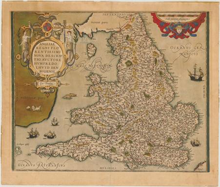
England & Wales (Angliae Regni Florentissimi Nova Descriptio, Auctore Humfredo Lhuyd Denbygiense), Ortelius, Theatrum Orbis Terrarum, Antwerp, 1573. 18.3 x 15”. (HC) Stunning map of England and Wales compiled from Mercator`s 1564 wall map of the British Isles and Lhuyd`s manuscript map of 1568. The countryside is fully engraved with topographical features and hundreds of towns. This map improved on Mercator`s outline of the countries particularly in Cardigan and South Wales, the Devon peninsula, and the Wash and Humber inlets. Interestingly the Caernarvon peninsula, near Lhuyd`s hometown of Denbigh, is badly distorted and it has been suggested that this may be due to his sketching it from one of the nearby mountains. Sea monsters and five sailing ships occupy the stipple engraved oceans. A flock of sheep is shown in Ireland and there are two large, elaborate cartouches. Dated 1573 in the cartouche and published in the Latin edition of 1592. Ref: Van den Broecke no.19.2; Shirley (BI) no.100. Old color on watermarked paper with some light color bleed through from verso just to the right of the title cartouche. There is light toning and remnants of hinge tape on verso. (+B)
![Northern Ireland (Ultonia Oriental), Mercator/Hondius, Atlas Minor, Amsterdam, [1607]. 7 x 6”. (HC) Charming map of Nor](http://lot-images.atgmedia.com/SR/36385/2862480/483-2012510164151_468x382.jpg)
Northern Ireland (Ultonia Oriental), Mercator/Hondius, Atlas Minor, Amsterdam, [1607]. 7 x 6”. (HC) Charming map of Northern Ireland including Belfast and extending south to Drogheda. Decorated with a large strapwork title cartouche, a sailing ship and a sea monster. This is from the first edition, with Latin text on verso. Ref: Law, p. 28. Watermarked paper with one tiny spot at bottom left and marginal soiling. Manuscript page number and cardinal directions in blank margins. (A)
![Southern Ireland (Hiberniae v. Tabula), Mercator/Hondius, Atlas Minor, Amsterdam, [1607]. 7.3 x 5.3”. (HC) A charming s](http://lot-images.atgmedia.com/SR/36385/2862480/484-2012510164156_468x382.jpg)
Southern Ireland (Hiberniae v. Tabula), Mercator/Hondius, Atlas Minor, Amsterdam, [1607]. 7.3 x 5.3”. (HC) A charming small map of southern Ireland, beautifully engraved both in the sea and the interior with detail of towns, rivers and mountains. The map is adorned with strapwork title and distance scale cartouches. This is from the first edition, with Latin text on verso. Ref: Law, p. 28. Watermarked paper with marginal soiling. Manuscript page number and cardinal directions in blank margins. (A)
![Gotland, Sweden (Gotlandia), Porcacchi, L`Isole piu Famose del Mondo, [1590]. 5.5 x 4”. (HC) Delightful map of the isla](http://lot-images.atgmedia.com/SR/36385/2862480/498-2012510164258_468x382.jpg)
Gotland, Sweden (Gotlandia), Porcacchi, L`Isole piu Famose del Mondo, [1590]. 5.5 x 4”. (HC) Delightful map of the island of Gotland surrounded by fanciful sea monsters, a compass rose and a figurative title cartouche. The land is fully engraved with mountains, forests and cities, and the sea is stipple engraved in the Italian style. Engraved by Girolamo Porro and printed on a full sheet (7 x 10.3") of Italian text. Ref: King (2nd Ed.), p. 57-59. Lovely color with a few faint spots in the image, marginal soiling, and manuscript writing in left blank margin. The left blank margin has also been reinforced on verso with old paper. (+B)

Denmark (Daniae Regni Typus), Ortelius, Theatrum Orbis Terrarum, Antwerp, ca. 1573. 16 x 12”. (HC) This striking map focuses on Denmark, but extends from the German coastline north to include part of the Norwegian coastline and the southern part of Sweden, including Stockholm. The map is based upon Cornelis Anthoniszoon`s Caerte van Oostand, and maps by Sgrothen, Olaus and Jordanus. A decorative title cartouche and large sailing ship complete the composition. Dutch text on verso. Ref: Van den Broecke no.84. Lovely old color on watermarked paper with light damp stains confined to the wide blank margins. French manuscript writing on verso opposing the Dutch text. (A)

Netherlands (Oost ende West Vrieslandts Beschrijvinghe. Utriusque Frisiorum Regeionis Noviss Description), Ortelius, Theatrum Orbis Terrarum, Antwerp, 1568. 20 x 13.3”. (HC) Handsome map of the northern part of the Netherlands, today`s provinces of Friesland, Groningen, Drenthe and part of Overijssel and Gelderland. Also shown is the adjacent part of Germany. To the north is the Waddenzee, with its string of offshore islands, decorated with several sailing ships. Large compass rose, distance scale and strapwork title cartouche adorn the map. First state with Dutch text on verso. Ref: Van den Broecke no.80.1 Lovely old color on watermarked paper with light damp stains in blank margins, barely entering map at corners. There is a small edge tear near the upper centerfold that has been repaired on verso with old paper. French manuscript writing on verso opposing the Dutch text. (+B)
![France (Regionis Biturigum Exactiss: Descriptio per D. Ioannem Calamaeum [on sheet with] Limaniae Topographia Gabriele Symeon](http://lot-images.atgmedia.com/SR/36385/2862480/519-2012510164450_468x382.jpg)
France (Regionis Biturigum Exactiss: Descriptio per D. Ioannem Calamaeum [on sheet with] Limaniae Topographia Gabriele Symeoneo Auct.), Ortelius, Theatrum Orbis Terrarum, Antwerp, ca. 1573. 19 x 12.1”. (HC) Two fine maps on a full folio sheet. The map of Biturigum is centered on Bourges, with the Loire River flowing at the top right of the map to Nevers. The cartography was based primarily on Jolivet`s map of 1545. The map of Limaniae is focused on the Allier River valley . This map was based on the work of Gabriel Symeoni. Each map is richly embellished with forests, cities, mountains and elaborate title cartouches. Dutch text on verso. Ref: Van den Broecke no.39. Attractive old color on watermarked paper with light damp stains in blank margins, barely entering map at bottom corners. French manuscript writing on verso opposing the Dutch text. (+B)
![Southern France (Aquitania), Mercator/Hondius, Atlas Minor, Amsterdam, [1607]. 7.3 x 5.5”. (HC) An attractive small map](http://lot-images.atgmedia.com/SR/36385/2862480/535-2012510164559_468x382.jpg)
Southern France (Aquitania), Mercator/Hondius, Atlas Minor, Amsterdam, [1607]. 7.3 x 5.5”. (HC) An attractive small map of southern France from the Atlantic coast to the Rhone River filled with detail and embellished with strapwork title and scale cartouches. This is from the first edition, with Latin text on verso. Marginal soiling with manuscript page number and cardinal directions in blank margins. (A)
![Western France (Poictou), Mercator/Hondius, Atlas Minor, Amsterdam, [1607]. 7.3 x 5.5”. (HC) This pretty, reduced versi](http://lot-images.atgmedia.com/SR/36385/2862480/540-2012510164630_468x382.jpg)
Western France (Poictou), Mercator/Hondius, Atlas Minor, Amsterdam, [1607]. 7.3 x 5.5”. (HC) This pretty, reduced version of Mercator`s map of the region includes the coastline and the cities of Nantes and Rochelle, with the Loire River valley prominently noted. A delicately engraved strapwork cartouche is tucked in the upper right corner. This is from the first edition, with Latin text on verso. Marginal soiling with manuscript page number and cardinal directions in blank margins. There are light pencil marks in the ocean. (+B)
![Eastern France and Northern Switzerland (Alsatia Superior), Mercator/Hondius, Atlas Minor, Amsterdam, [1607]. 7 x 5.5”.](http://lot-images.atgmedia.com/SR/36385/2862480/546-201251016475_468x382.jpg)
Eastern France and Northern Switzerland (Alsatia Superior), Mercator/Hondius, Atlas Minor, Amsterdam, [1607]. 7 x 5.5”. (HC) Finely engraved map of the Alsace region and the course of the Rhine River from Basel to Strasburg. North is oriented to the right, and a strapwork cartouche incorporating the distance scale adorns the map. This is from the first edition, with Latin text on verso. There are two tiny spots in the image, a printer`s crease in the title cartouche, and marginal soiling. Manuscript page number and cardinal directions in blank margins. (+B)
![Spain & Portugal (Hispania), Mercator/Hondius, Atlas Minor, Amsterdam, [1607]. 7.3 x 5.5”. (HC) Charming miniature](http://lot-images.atgmedia.com/SR/36385/2862480/557-201251016486_468x382.jpg)
Spain & Portugal (Hispania), Mercator/Hondius, Atlas Minor, Amsterdam, [1607]. 7.3 x 5.5”. (HC) Charming miniature map of the Iberian Peninsula and the Balearic Islands with considerable detail throughout. A sailing ship is shown entering the Straits of Gibraltar and a large strapwork title cartouche further decorates the map. This is from the first edition, with Latin text on verso. Marginal soiling with manuscript page number and cardinal directions in blank margins. (A)
![Eastern Spain (Regni Valentiae Typus), Mercator/Hondius, Atlas Minor, Amsterdam, [1607]. 7.3 x 5.8”. (HC) Beautiful sma](http://lot-images.atgmedia.com/SR/36385/2862480/566-2012510164855_468x382.jpg)
Eastern Spain (Regni Valentiae Typus), Mercator/Hondius, Atlas Minor, Amsterdam, [1607]. 7.3 x 5.8”. (HC) Beautiful small map of Valencia covering the coastline from Cartagena to Benicarlo with north oriented to the right. It is decorated with a sailing ship, sea monster, and strapwork title and distance scale cartouches. This is from the first edition, with Latin text on verso. Marginal soiling with a light damp stain in blank margin at top left. Manuscript page number and cardinal directions in blank margins. (A)

Portugal (Portugalliae que olim Lusitania, Novissima & Exactissima Descriptio Auctore Vernando Alvaro Secco), Ortelius, Theatrum Orbis Terrarum, Antwerp, ca. 1573. 20 x 13.3”. (HC) This is one of the earliest and most beautiful maps of Portugal. It is oriented with north to the right and richly adorned with two large cartouches, sailing ships and a very devilish-looking sea monster. The map is based on Fernando Alvarez Secco`s map of 1560. The cartouche at bottom contains a dedication to Cardinal Camerlengo, Guido Ascanius Sfortia, from Secco that enumerates the great achievements of Portugal. Dutch text on verso. Ref: Van den Broecke no.26. Lovely old color on watermarked paper with light damp stains in blank margins, barely entering map at corners. French manuscript writing on verso opposing the Dutch text. (+B)

Germany (Saxoniae, Misniae, Thuringiae, Nova Exactissimaq Descriptio), Ortelius, Theatrum Orbis Terrarum, Antwerp, ca. 1573. 19.8 x 13.5”. (HC) This handsome map covers Saxony and the surrounding region with great detail. It is embellished with a decorative title cartouche, a legend in scroll-style cartouche, distance scales and a decorative border. The map is filled with place names, each symbolized by a tiny castle. Dutch text on verso. Ref: Van den Broecke no.93. Attractive old color on watermarked paper with light damp stains in blank margins. French manuscript writing on verso opposing the Dutch text. (A)
![Germany and Russia (Thietmarsiae, Holsaticae Regionis Partis Typus [on sheet with] Prussiae Descriptio…), Ortelius, The](http://lot-images.atgmedia.com/SR/36385/2862480/591-2012510165059_468x382.jpg)
Germany and Russia (Thietmarsiae, Holsaticae Regionis Partis Typus [on sheet with] Prussiae Descriptio…), Ortelius, Theatrum Orbis Terrarum, Antwerp, ca. 1573. 17 x 12”. (HC) Two maps on a folio sheet, each with decorative cartouches and a ship or sea monster. The first covers the region known as Dietmarschen in Schleswig Holstein at the mouths of the Elbe and Eider rivers including Brunsbuttel and Meldorf. The cartouche attributes the map to Petrus Boeckel. The second map covers part of the Prussian Empire, which is the present-day Russian enclave of Kaliningrad (here Kunigsberg). Ortelius based this map on the work of Heinrich Zell. Dutch text on verso. Ref: Van den Broecke no.88. Attractive old color on watermarked paper with light damp stains confined to the wide blank margins. French manuscript writing on verso opposing the Dutch text. (A)
![Central Germany (Hassia Landgraviatus), Mercator/Hondius, Atlas Minor, Amsterdam, [1607]. 7.3 x 5.5”. (HC) Handsome sma](http://lot-images.atgmedia.com/SR/36385/2862480/602-2012510165157_468x382.jpg)
Central Germany (Hassia Landgraviatus), Mercator/Hondius, Atlas Minor, Amsterdam, [1607]. 7.3 x 5.5”. (HC) Handsome small map of the state of Hesse detailing the course of the Fulda and Lon Rivers, filled with information of cities, villages, forests and mountains. Decorated with a strapwork title cartouche incorporating a distance scale. This is from the first edition, with Latin text on verso. Marginal soiling with manuscript page number and cardinal directions in blank margins. (A)
![Western Austria (Saltzburg Carinthia), Mercator/Hondius, Atlas Minor, Amsterdam, [1607]. 7.3 x 5.5”. (HC) Attractive sm](http://lot-images.atgmedia.com/SR/36385/2862480/622-2012510165338_468x382.jpg)
Western Austria (Saltzburg Carinthia), Mercator/Hondius, Atlas Minor, Amsterdam, [1607]. 7.3 x 5.5”. (HC) Attractive small map of the historic Salzburg and Corinthian regions. Fully engraved to illustrate the mountainous terrain filled with rivers, lakes, forests and villages. Decorated with a strapwork title cartouche incorporating a distance scale. This is from the first edition, with Latin text on verso. Lightly toned with marginal soiling and a damp stain in blank margin at top left. Manuscript page number and cardinal directions in blank margins. (+B)
![Western Russia (Moscovia), Mercator/Hondius, Atlas Minor, Amsterdam, [1607]. 6.8 x 5.3”. (HC) Handsome map of western R](http://lot-images.atgmedia.com/SR/36385/2862480/634-2012510165438_468x382.jpg)
Western Russia (Moscovia), Mercator/Hondius, Atlas Minor, Amsterdam, [1607]. 6.8 x 5.3”. (HC) Handsome map of western Russia with Moscow (Moscowia) depicted at lower right and Novgorod (Nouogardia) at top left. Fully engraved to show forests, rivers, lakes and cities and adorned with decorative title and scale cartouches. This is from the first edition, with a blank verso. Marginal soiling. Manuscript page number, cardinal directions, and a notation in blank margins. (A)
![Greece, Balkans (Macedonia, Epir. et Achaia), Mercator/Hondius, Atlas Minor, Amsterdam, [1607]. 7.3 x 5.5”. (HC) A fine](http://lot-images.atgmedia.com/SR/36385/2862480/654-2012510165614_468x382.jpg)
Greece, Balkans (Macedonia, Epir. et Achaia), Mercator/Hondius, Atlas Minor, Amsterdam, [1607]. 7.3 x 5.5”. (HC) A fine small map covering northern Greece and Albania with part of Macedonia. The title and distance scale are enclosed in a strapwork cartouche. This is from the first edition, with Latin text on verso. Light show-through of text on verso with a couple of tiny spots in the image. Manuscript page number and cardinal directions in blank margins. (+B)
-
33306 item(s)/page