We found 33304 price guide item(s) matching your search
There are 33304 lots that match your search criteria. Subscribe now to get instant access to the full price guide service.
Click here to subscribe- List
- Grid
-
33304 item(s)/page


![Strada, Famiamo, S.J. 1648 De Bello Belgico [with book] Famiani Stradae Romani E Societate Jesu De Bello Belgico Decas Secund](http://lot-images.atgmedia.com/SR/36385/2893812/2-2013117141448_468x382.jpg)
Lot 2
Strada, Famiamo, S.J. 1648 De Bello Belgico [with book] Famiani Stradae Romani E Societate Jesu De Bello Belgico Decas Secunda "This frontispiece is the famous “Leo Belgicus”, or Lion of Belgium, depicting a map of Belgium and Holland in the form of a lion. This version of the Leo Belgicus is based on the original Aitsinger form with the lion standing facing right with the right paw raised and holding a shield. This is one of the smallest versions of all the Leos, measuring only 2.6 x 4.8”. The frontispiece appears in the popular history describing the war between the Low Countries and Spain from a pro-Spanish and pro-Catholic viewpoint. Famiamo Strada was a Jesuit and teacher at the Collegium Romanum in Rome. The book also includes a title page, nine engraved portraits, 642 pages and an extended index. Original vellum binding with raised bands and manuscript ink title on spine. This example has the stamp of Lord Milford and the signature of Sir Erasmus Phillips in the front endpapers." 3" W x 4.8" H The map and text are lightly toned with marginal soiling. The binding is sound and the covers and spine are moderately soiled and bumped.
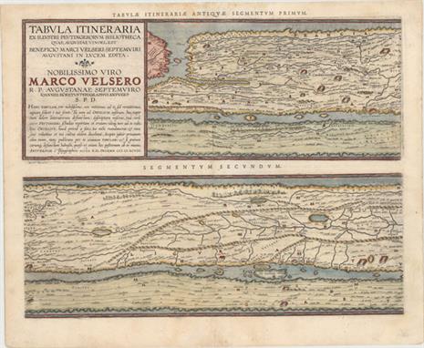
Lot 47
Ortelius, Abraham 1598 Tabula Itineraria ex Illustri Peutingerorum Bibliotheca…Nobilissimo Viro Marco Velsero "These four sheets are Ortelius` scarce version of the famous “Peutinger Table.” These decorative maps, in a sequence of four plates, each with two strip maps, depict the imperial roads and posts within the Roman Empire throughout Europe, North Africa and Asia as far as “Toprobana” (Sri Lanka). The format distorts the landmasses, but provides an excellent view of the cities and roads, which include distances between the posts. The three most important cities of the Roman Empire, Rome, Constantinople and Antioch, are represented by enlarged symbols including the emperor seated on a throne. Size given is for each plate. The original parchment document for this incredible map is thought to have been made in the thirteenth century. The original now resides in the Vienna National Library, but is so damaged that the Ortelius version is now the most reliable representation. The “Peutinger Table”, as it is generally known, derived its name from Konrad Peutinger, who once owned the original. Ortelius had manuscript copies made in 1598 from the original scroll and supervised the engraving, but did not live to see their publication. This is the Parergon edition with Latin text on verso, printed by Balthasar Moretus and published in 1624." 20.5" W x 15.5" H Watermarked paper with attractive color, light soiling, a faint damp stain along centerfold at top, and professional repairs to some centerfold separations. There are tears that enter map image 1" at bottom on 1st sheet, 2" at top on 2nd sheet, and 1/2" at bottom on 4th sheet that have all been professionally repaired.
![1835-50 [Lot of 2] Etats-Unis de l`Amerique du Nord [and] Etats-Unis et Nouvelle Bretagne "A. “Etats-Unis de l`Ame](http://lot-images.atgmedia.com/SR/36385/2893812/91-2013117143314_468x382.jpg)
Lot 91
1835-50 [Lot of 2] Etats-Unis de l`Amerique du Nord [and] Etats-Unis et Nouvelle Bretagne "A. “Etats-Unis de l`Amerique du Nord”, by Charles Monin, circa 1835, black and white (10.4 x 7.9”). Here the United States extends past the Rockies to show part of Oregon Territory. Interesting territorial borders are depicted including a large Arkansas Territory and several named Indian districts -- Huron, Sioux, Osage, Ozark, Mandan. Texas is named separately from Mexico, however there is no formal border to the south. Condition: There are a few faint spots in the image with a manuscript notation in the right blank margin. B. “Etats-Unis et Nouvelle Bretagne”, by Louis Antoine, circa 1850, hand color (11.2 x 8.7”). The United States here stretches all the way to California with the acquisition of the Southwest from Mexico. A small New Mexico territory is surrounded by the much larger New California and the state of Texas. Large Missouri, Iowa and Indian territories occupy the Plains, and the border with Canada reflects a current configuration. Decorated by a keyboard style border. Condition: There are just a few minor spots of foxing in the image and damp stains in the left and right blank margins." #VALUE! See description.

Lot 148
Blaeu, Willem 1662 Nova Belgica et Anglia Nova This important map, first issued in 1635, is one of the first to focus on the Dutch colony in North America and to name "Nieu Amsterdam" (New York). It is based on the manuscript of Andriaen Block (1614), a Dutch fur trader, who explored the area between Cape Cod and Manhattan and was the first to correctly delineate the longitudinal scale of the coastline and establish Manhattan as an island. The colony of "Nieu Pleimonth" is identified, as well as other English names along the coast, which were derived from Smith`s map of New England in 1616. The map is oriented with north to the right and is richly adorned with a variety of wildlife, including the first appearance of beavers, polecats and otters on a printed map. Quebec is noted with a minute depiction of the fort and buildings, and the mythical kingdom pf "Norumbega" is noted near the" R. Pentagouet " (Penobscot River) in present-day Maine. A large Mohawk village is shown derived from the White-de Bry engravings. It is further embellished with a large title cartouche flanked by two natives, sailing ships, canoes, and compass roses. Latin text on verso. 19.7" W x 15.2" H A fine impression with wide, original margins, light show-through of text on verso, and a number of tiny worm holes along centerfold that have been professionally infilled with a small amount of image in facsimile. There are some small chips and tears in blank margins that have also been professionally repaired.

Lot 225
Sayer & Bennett, 1775 A Plan of the Battle, on Bunkers Hill. Fought on the 17th of June 1775. By an Officer on the Spot "This very rare broadside gives a fascinating British perspective on the Battle of Bunkers Hill. The map gives a panoramic scene of the warfare from the Charlestown Neck north of the Charlestown Peninsula to the Roxbury Neck just south of Boston. The plan depicts the locations and movements of the major players during the battle. Warren`s redoubt and several lines of American forces are shown in yellow along Breed`s Hill (which is not named), adjacent to the city of Charlestown. The advancements of General Howe and Brigadier General Pigot are depicted in red moving from the beach north towards Breed`s Hill. British warships are shown at the mouth of the Charles River. There is scarce detail within the town of Boston with the exception of several British fortifications, including a fort, two redoubts, batteries, and the location of Generals Burgoyne and Clinton`s troops during the battle at the Cobbs Hill battery. One of the most interesting aspects of the plan is a note near the Charlestown Neck, “Hither the ships ought to have come,” referring to General Clinton`s recommendation that the British attack the rebels from the north, thereby preventing their retreat. Clinton was outvoted by his fellow generals, and the Battle of Bunkers Hill resulted in a costly victory for the British army due to the number of casualties. In addition, the conflict served as one of the first steps towards American Independence by giving the rebels a moral victory and the determination to carry on with the war. One week after the battle, General Burgoyne wrote a letter to his nephew Lord Stanley, describing the battle in colorful detail. The letter is reproduced below the map, and explains how the British realized that control over Boston was dependent on the British also securing both the Charlestown and Dorchester peninsulas. Burgoyne explains that although he and his fellow commanding officers had determined to attack Dorchester first (scheduled for June 18th), after hearing of the movements of the colonials in the north, they shifted their focus to Charlestown and Bunkers Hill. After describing the operations of the British troops, the ensuing battle, and the heroism of the British army, Burgoyne lists the key casualties of the confrontation. This broadside was separately issued by Sayer & Bennett on November 27, 1775 and is historically significant both for its broad view of the full battlefield and for Burgoyne`s important account of the battle. Full sheet with text measures 19.6 x 14.6”. This is a unique opportunity to own an example of this rare map that has been expertly repaired and conserved for a fraction of the cost of its typical retail value of $30,000-50,000." 13.7" W x 13.6" H This map has been expertly conserved, with numerous small chips into image at top, left and bottom, as well as a 1 x 10" strip along the right-hand edge at bottom all repaired with image skillfully and seamlessly replaced in facsimile. Remargined on all sides and backed in Japanese tissue to repair a few short tears in the image. On watermarked paper with a few small abrasions, toning, and moderate soiling. There are also minute pinholes along the engraved lines of the map (now reinforced with the Japanese tissue on verso), indicating that a previous owner made a manuscript copy of the map.

Lot 266
Robert de Vaugondy, Didier 1772 Carte de la Californie Suivant I. la Carte Manuscrite de l`Amerique de Mathieu Neron Pecci... This sheet has five depictions of California that present a fascinating cartographic history of the region. It was one of ten maps compiled by Robert de Vaugondy for Diderot`s important encyclopedia and depicts the mapping of California by five important cartographers. The earliest map reproduces Neron Pecci`s manuscript map of 1604 showing the peninsula with a ragged coastline and place names derived from Cabrillo`s voyage of 1542-3. The second map is a detail from Sanson`s 1656 map showing the "island of California" with place names from the voyage of Vizcaino. Map three is from Delisle`s map of America of 1700 with the question of California`s insularity left open to interpretation. Next is Fra. Eusebio Kino`s important map of 1705 that finally ended that cartographic myth. It is based on his overland expedition from the mainland to the Sea of Cortez. Finally, map five is a portion of a Spanish map, showing the Jesuit explorations, that first appeared in Miguel Venegas` "Noticia de la California" in 1757, which is the first published history of California. This is an essential map for any California map collection. 15.3" W x 11.5" H Issued folding, now pressed flat, with faint printer`s ink residue. Trimmed close to neatline at left.
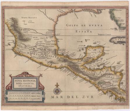
Lot 267
Gerritsz/De Laet, 1625 Nova Hispania, Nova Galicia, Guatimala This fine map is the work of Hessel Gerritsz, one of the most important Dutch cartographers of the 17th century. Most of his work exists only in manuscript and these maps, published by De Laet, are the only Gerritsz maps available to the collector today. The map includes Mexico through Costa Rica with considerable detail. The large strapwork cartouche incorporates the title and distance scales and the map is further decorated with a lovely compass rose. 14.2" W x 11.2" H A nice impression on watermarked paper with archival repairs to a 1/2" tear in Pacific and several short marginal tears, only one of which enters map border at bottom. Very narrow side margins, as issued.

Lot 320
Herrera y Tordesillas, Antonio de 1726 Descripcion de las Yndias de Mediodia Antonio de Herrera Y Tordelisllas was the official historian of Spain and the Indies. He compiled a history of the Spanish conquests and early explorations in the Americas, which included this simply engraved map of the continent. His work ("Historia general de los hechos de los Castellanos") was originally published in 1601 with several editions and translations thereafter, all of which are scarce. This map is from an early 18th century edition published by Nicolas Rodriguez. This rare map is largely derived from the manuscript charts of Juan Lopez de Velasco. The continent is dominated by the huge "R. de los Amazona" and "R. de la Plato" and the western mountain range. The Papal Line of Demarcation ("Meridiano de la de Marcacion"), which divided the non-Christian world between Spain and Portugal, divides the continent between Portugal’s tiny Brazil with the rest (Peru) belonging to Spain. 9.2" W x 8.4" H A nice impression on watermarked paper with generous margins. There are a few small worm holes along the centerfold that have been archivally repaired.

Lot 344
Anon., 1840 Mapa Topografico de la Provincia de Sana en el Obispado de Truxillo en el Reino del Peru "Manuscript map" that shows the northwestern coast of Peru from the Piura region to today`s La Libertad region, here called "Provincia de Truxillo". Several towns are identified, with a small drawing of a building to denote each one. There is a fleur-de-lis in the "Mar del Sur" that orients north to the left, as wells as a few islands: "Ysla de Lobos de Tierra", "Ysla de Lobos de Fuera", and "Farallones de Malabrigo". 15.8" W x 11.2" H On watermarked paper with light scattered foxing and several tiny holes that are only visible when held up to light. The margin has been extended at left with old paper. Ex libris stamp on verso.
![Porcacchi, Tomaso 1576 [Lot of 17 - Greece] "This lot includes 17 maps of Greece and its islands published in Porcacchi`](http://lot-images.atgmedia.com/SR/36385/2893812/495-2013117142354_468x382.jpg)
Lot 495
Porcacchi, Tomaso 1576 [Lot of 17 - Greece] "This lot includes 17 maps of Greece and its islands published in Porcacchi`s “L`Isole piu Famose del Mondo”, all engraved by Girolamo Porro of Padua. Each map is on a full sheet of Italian text (7.0 x 10.5”). Size varies slightly. This lot includes: A. “Arcipelago”. Condition: A spot of printer`s ink residue and marginal soiling. (B+) B. “Il Sito de` Curzolari”. Condition: There are a number of cracks that have been closed on verso with archival tape and marginal soiling. (B) C. “Morea Penisola”. Condition: Light soiling and a few small worm holes in text below map. (B+) D. “Negroponte”Condition: Numerous minute pinholes along coastlines, light soiling, and manuscript writing in blank margins. (B) E. “Corfu”Condition: Light soiling with one small ink spot in image. (B+) F. “Milo”Condition: Light soiling with a few small worm holes in image at left. (B) G. “Zante”Condition: Light soiling with a printer`s crease above compass rose. (B+) H. “Scarpanto”Condition: Some soiling with a worm track in text below map. (B+) I. “Rhodi”Condition: Minor soiling. (B+) J. “Candia”Condition: There is light soiling, show-through of manuscript ink on verso, and a worm track in text below map. There is an old paper repair in right blank margin. (B) K. “Santorini”Condition: A couple of faint spots and a tiny worm hole in left blank margin. (B+) L. “Stalimene”Condition: Light soiling. (B+) M. “Metellino”Condition: Marginal soiling. (A) N. “Scio”Condition: Light soiling. (B+) O. “Nicsia”Condition: There are a few small worm holes in map at left, and an old paper repair in left blank margin. (B+) P. “Cefalonia”Condition: Light soiling with a small worm hole and ink stains in text below map. (B+) Q. “Cerigo”Condition: Light soiling with a worm track in text below map. (B+)" 5.5" W x 4" H See description.

Lot 506
Mercator/Hondius, 1607 Lombardiae Alpestris Pars Occidentalis cu Valesia Handsome small map of the mountainous Lombardy region of northern Italy with the glacial lakes of Maggiore, Lugaro and Como roughly in the center and Lake Geneva to the left. The map is simply ornamented with a strapwork title cartouche that incorporates the distance scale. This is from the first edition, with Latin text on verso. 7.3" W x 5.8" H A dark impression with marginal soiling. Cardinal directions and page number written in manuscript ink in blank margins.

Lot 513
Ortelius, Abraham 1574 Regni Neapolitani Verissima Secundum Antiquorum et Recentiorum Traditionem Descriptio, Pyrrho Ligorio Auct. This is a beautiful map of southern Italy with north oriented to the left as identified by the handsome compass rose. The map is filled with detail and based on the work of Pirro Ligorio who was best known as an architect involved in the building of St. Peter`s in Rome. The title is contained in a flowing banner and a fine sailing ship further adorns the map. Latin text on verso, published between 1574-75. 19.8" W x 14.5" H Watermarked paper with professional repairs to a centerfold separation that enters 2.5" into map at bottom and some small chips confined to blank margins. There are a couple of faded manuscript ink notations on map.

Lot 565
Porcacchi, Tomaso 1572 Constantinopoli This uncommon map is based on Munster`s important early bird`s-eye view of the Golden Horn of Constantinople. It shows the major sections of the city with the palaces, mosques and churches. Several types of ships and boats are shown in the Bosphorus Strait. Printed on a full sheet of Italian text (7.2 x 10.4"). 5.5" W x 4" H A few small spots in image with manuscript writing and soiling in blank margins.
![Moxon, Joseph 1715 The Holy Bible, Containing the Old and New Testaments... [bound with] The Book of Common Prayer [and 6 Bib](http://lot-images.atgmedia.com/SR/36385/2893812/567-2013117142618_468x382.jpg)
Lot 567
Moxon, Joseph 1715 The Holy Bible, Containing the Old and New Testaments... [bound with] The Book of Common Prayer [and 6 Biblical maps] "This magnificent folio-sized King James Bible is bound with “The Book of Common Prayer”, “The Books Called Apocrypha”, “The New Testament”, and “The Whole Book of Psalms: Collected into English Metre” by Thomas Sternhold and John Hopkins. This edition of the King James Bible includes marginal notes from the Geneva Bible, an ironic combination because the Geneva Notes apparently played a role in King James` decision to commission a new Bible. In addition, this Bible features a series of 6 Biblical maps originally by Nicholas Visscher and translated from Dutch by Joseph Moxon: A. “A Map of All the Earth and How After the Flood it Was Divided Among the Sons of Noah”. The map illustrates how the world was divided up among the sons of Noah after the Flood. It is centered on the Old World and only the place names are concentrated there. The rest of the world is shown only with continental outlines, rivers and lakes. The “island of California” appears across the expansive Pacific Ocean where there are partial outlines for Japan, Australia and New Zealand. A series of vignettes surround the map illustrating the Creation and the Garden of Eden at top, with scenes from the Fall of Man to the Crucifixion of Christ at bottom. Two cartouches further decorate the sheet, including a dedication to Gilbert Sheldon, Archbishop of Canterbury. This is the second state, with the addition of Pennsylvania marked on the map. Reference: Shirley #457; Laor #516A. B. “Paradise, or the Garden of Eden. With the Countries Circumjacent Inhabited by the Patriarchs”. An attractive and uncommon map of the Middle East, including Cyprus, a portion of the Persian Gulf and the north shore of the Red Sea filled with details of Old Testament locations, including Babel and Nineveh. There is a coat of arms at upper left and a cartouche at upper right showing the expulsion of Adam and Eve from Paradise by the Angel. Reference: Laor #517. C. “Israels Peregrination, or the Forty Years Travels of the Children of Israel out of Egypt through the Red Sea, and the Wilderness into Canaan, or the Land of Promise”. This lavishly decorated map of the Holy Land depicts the flight from Egypt and the wanderings of the Children of Israel. Includes a fine title cartouche, ships sailing in both the Mediterranean and Red Seas, numerous putti, several engravings of religious icons, Moses, Aaron, and a charming scene of Jonas and the whale. Reference: Laor #519. D. “Jerusalem”. This detailed bird`s-eye view was one of the most popular plans of Jerusalem during the seventeenth century. While it is imaginary, it provides great detail of the city walls and streets, with 36 principal sites numbered and keyed to a table in a scroll at left, which is held aloft by an eagle. Solomon`s Temple is at upper center and Herod`s Palace is located at the far left. The scenes in the foreground include the Crucifixion at left and Salomon`s anointment at right. Reference: Laor #1084A. E. “Canaan, or the Land of Promise. Possessed by the Children of Israel: and Travelled Through by our Saviour Jesus Christ; and His Apostles”. This fine map of present-day Israel is oriented with north to the right. There is a large, decorative title cartouche at bottom flanked by vignettes depicting the life of Christ. At top, putti hold banners with the key to the map and scale of miles. Tiny ships and the track of Apostle Paul are shown in the sea. At top center is a coat of arms with a dedication to Lord Bishop Humphrey. Reference: Laor #522A. F. “The Travels of St. Paul and Other the Apostles...” This map portrays the Eastern Mediterranean from Rome, through Asia Minor and the Holy Land, to Babylon. Territorial divisions reflect the political conditions of the first century A.D. The route of Apostle Paul is charted from Jerusalem to Rome. The decorative panels at top and bottom show the major events of Paul`s journey; each vignette being a composite of two or three episodes. The one at the left of the cartouche shows Paul`s conversion, his baptism by Ananias, and finally his daring escape from the city. Other scenes depict the young Paul before his conversion, healing the paralytic, his ship wreck at Malta, and his appearance before Nero. At bottom left is a coat of arms with a dedication to Seth, Lord Bishop of Salisbury. Reference: Laor #523A. This example also includes three pages of meticulous genealogical notes of the Joseph Maude and Thomas Holme families (from 1662-1863) written in delicate manuscript by a previous owner. 6 maps, 91pp, 719pp, 160pp, 248pp, 54pp. Original full diced paneled brown calf over beveled wooden boards, with a central, ornate blind-stamped lozenge to each board, and raised bands on spine. The original brass clasps and catches are no longer present." 10.6" W x 16.8" H Five of the six maps are in very good condition with faint, scattered foxing and minor offsetting. The sixth map (Canaan) is in good condition with some show-through of old manuscript ink on verso. The text is mostly very good with light scattered foxing and toning, with heavy toning on the first and last few pages. The binding is sound but the hinges are starting. The front cover is cracked vertically near the fore-edge and has been professionally repaired. The spine is cracking and is missing a 4x2" piece at bottom. There is a bookplate from a previous owner (Rosa Walter Meertief, born c. 1872) on front pastedown.

Lot 569
Ortelius, Abraham 1590 Abrahami Patriarchae Peregrinatio, et Vita Ortelius designed, and probably also engraved this beautiful Holy Land map. It details the wanderings and life of the Patriarch Abraham. The map is displayed as though on a banner hung on a wall; it shows Palestine and a portion of Egypt, inset with a small map of the Middle East from the Mediterranean to the Euphrates River. The imaginative design includes an elaborately engraved frame containing twenty-two scenes illustrating the life of Abraham, spanning his departure from Ur to his death. This is less common first plate, which was used from 1590-95. This example has a blank verso, indicating that it was published in the 1590 Latin edition, of which Van den Broecke estimates that only 20 copies were printed. 18" W x 13.9" H A fine impression and excellent color on watermarked paper with a few small, manuscript ink notations (on the fourth medallion and on the wooden roller holding up the map).
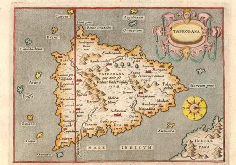
Lot 644
Porcacchi, Tomaso 1576 Taprobana Charming map of the island nation of Sri Lanka with north oriented to the right of the map. Only a bit of the Indian mainland is shown and it is incorrectly depicted to the east of the island. Strapwork title cartouche, an unusual compass rose and a stipple engraved sea combine to make this a very attractive map. Engraved by Girolamo Porro and printed on a full sheet (7 x 10.3") of Italian text. 5.5" W x 4" H Marginal soiling and manuscript ink above the map.
![Anon., 1430 [Illuminated Leaf] "A nice vellum manuscript from a French Book of Hours, in the style of a Rouen scriptoriu](http://lot-images.atgmedia.com/SR/36385/2893812/712-2013117143116_468x382.jpg)
Lot 712
Anon., 1430 [Illuminated Leaf] "A nice vellum manuscript from a French Book of Hours, in the style of a Rouen scriptorium. Written in brown and red ink, the leaf has two large initials and numerous small initials and line fillers in red and blue and burnished gold leaf, as well as a decorative panel in the margin on both sides with ivy and flowers. The text is from the Nativity, St. Matthew, chapter 2. Beginning on recto at top, the text translates into English as: “In Bethlehem in Judea,” they replied, “for this is what the prophet has written: “ `But you, Bethlehem, in the land of Judah, are by no means least among the rulers of Judah; for out of you will come a ruler who will be the shepherd of my people Israel.` “ Then Herod called the Magi secretly and found out from them the exact time the star had appeared. He sent them to Bethlehem and said, “Go and make a careful search for the child. As soon as you find him, report to me, so that I too may go and worship him.” " 4.4" W x 6" H Light soiling with one tiny hole in decorative floral panel.
![Hardouin, Gilles 1518 [Illuminated Leaf] "This leaf is from a Book of Hours printed on vellum by Gilles Hardouin for Ger](http://lot-images.atgmedia.com/SR/36385/2893812/724-2013117143141_468x382.jpg)
Lot 724
Hardouin, Gilles 1518 [Illuminated Leaf] "This leaf is from a Book of Hours printed on vellum by Gilles Hardouin for Germain Hardouin “librayre demourant entre les deux portes du Palays en l’enseigne Saincte Marguerite” (bookseller living between the two gates of the Palace at the sign of Saint Marguerite) of Paris. This leaf is from the transitional period when the new technology of printing with movable type was combined with the more labor intensive methods of hand painting. Illuminated manuscript books of hours were costly to make, and early printers realized the commercial value in printing larger quantities of illustrated books of hours at a lower cost. These printers tried to make their books of hours appear as similar to the manuscript books as possible, even going so far as to mimic the red lines scribes used to keep their text uniform. This exquisitely crafted vellum leaf is highlighted by illuminated capitals painted in red, blue and liquid gold. The text on recto is from Psalm 66, beginning with the large “D”: Deus misereatur nostri et benedicat nobis inluminet vultum suum super nos et misereatur nostri Ut cognoscamus in terra viam tuam in omnibus gentibus salutare tuum Confiteantur tibi populi Deus confiteantur tibi populi omnes Laetentur et exultent gentes quoniam iudicas populos in aequitate et gentes in terra diriges This translates into English as: May God have mercy on us, and bless us: may he cause the light of his countenance to shine upon us, and may he have mercy on us. That we may know thy way upon earth: thy salvation in all nations. Let people confess to thee, O God: let all people give praise to thee. Let the nations be glad and rejoice: for thou judgest the people with justice, and directest the nations upon earth." 4.6" W x 7.4" H Marginal soiling.
![Hardouin, Gilles 1518 [Illuminated Leaf] This leaf is from a Book of Hours printed on vellum by Gilles Hardouin for Germain H](http://lot-images.atgmedia.com/SR/36385/2893812/725-2013117143143_468x382.jpg)
Lot 725
Hardouin, Gilles 1518 [Illuminated Leaf] This leaf is from a Book of Hours printed on vellum by Gilles Hardouin for Germain Hardouin "librayre demourant entre les deux portes du Palays en l’enseigne Saincte Marguerite" (bookseller living between the two gates of the Palace at the sign of Saint Marguerite) of Paris. This leaf is from the transitional period when the new technology of printing with movable type was combined with the more labor intensive methods of hand painting. Illuminated manuscript books of hours were costly to make, and early printers realized the commercial value in printing larger quantities of illustrated books of hours at a lower cost. These printers tried to make their books of hours appear as similar to the manuscript books as possible, even going so far as to mimic the red lines scribes used to keep their text uniform. This sheet is part of the calendar for July, August, September and October. Each month begins with the large illuminated initials "KL" (for Kalender), and lists the number of days in the month as well as the name day of many saints. Peculiar is the fact that the calendar also says in what sign of the Zodiac the sun was at a certain date: in July – "Sol in leone". 4.6" W x 7.4" H Marginal soiling.
![1751 [Vellum Manuscript Indenture] This document is a will that entitles Margaret Gorham, the widow of William Gorham, the yo](http://lot-images.atgmedia.com/SR/36385/2893812/726-2013117143144_468x382.jpg)
Lot 726
1751 [Vellum Manuscript Indenture] This document is a will that entitles Margaret Gorham, the widow of William Gorham, the younger, to his property and land at Kings Cliffe Manor. The Manor at Kings Cliffe, in Northamptonshire, was built in the early 17th century. An attractive blue embossed seal with foil appears at top left. 12.5" W x 10" H Light soiling with some stains and abrasions at far right.
Lot 193
Quantity of printed and manuscript documents including lease, agreement and trust documents on vellum WITH a folding coloured panorama "The Great Glass House Opend The Exhibition Wot Is". 1951. Oblong 8vo. by George Augustus Sala and a quantity of printed documents including Indian School Certificates

![[LOCAL HISTORY: MILLAND] DAVIS (Thomas, of Godalming) “A Survey of William Richardson Esq.r’s Estates Call’](http://lot-images.atgmedia.com/SR/1794/2893472/411-201311718482_468x382.jpg)
Lot 411
[LOCAL HISTORY: MILLAND] DAVIS (Thomas, of Godalming) “A Survey of William Richardson Esq.r’s Estates Call’d Mill Land & c. In the Parishes of Trotton, Iping and Stedham in the County of Sussex,” sm. folio MANUSCRIPT, 20ff. (written on rectos only), hand drawn map/survey on vellum at rear, contemp. calf, [Godalming], 1774; with a map of the Coldharbour Wood Estate, 1932, loosely inserted. NOTE: the manuscript details field names, land type; the latter part of the ms. gives considerable detail, the result of Davis’s field walking, on the field boundaries, landmarks, local personages, etc. under the headings ‘Perambulation of Rogate Bohunt Manor/Clark’s Dean Moor.’ [see illustration]

Lot 34
Casati, Major Goetano TEN YEARS IN EQUATORIA AND THE RETURN WITH EMIN PASHA London & New York: Frederick Warne & Co., 1891 Colonial edition large 8vo Translated from the original Italian Manuscript, 150 illustrations full red grained leather with highly decorated banded spine. Bookplate of Sir James Liege Hulett, regular foxing. Marbled endpapers and another of related interest ♦ HARRIS, JOHN H. - Dawn in Darkest Africa, 1912, with illustrations and map. 0 1

Lot 2023
(x) Historical DocumentsFifteenth Century manuscript page from a medical Book of Remedies, in English and well written in a fine hand which is easy to read, on paper, with two-line intial capitals in red. With remedies for worms, "Stinging of a Serpent", "Biting of a Mad Hounde" and "For hym that may not sleepe". Some staining on the outer edge. Scarce and interesting with some fine caligraphy. Probably from a manor or grand house of the time. From the Gerald E. Wellburn collection. Photo Subject to 5% tax on Hammer Price in addition to 20% VAT on Buyer’s Premium. For more information please view Terms and Conditions for Buyers.

Lot 2047
(x) Historical DocumentsKing Louis XIV1650 (12 May) letter to the "gens du Comité du Royanme d'Escosse" in Scotland, signed "Louis", an early and young signature written when he was only twelve years of age. The letter with vertical cut to carry the royal seal (missing) with the manuscript endorsement "K of France"; some soiling at edges and along folds. The letter refers to his regiment, the Scots Guards, "Regiment de ma gardea escossoisea". From the Gerald E. Wellburn collection. Photo Subject to 5% tax on Hammer Price in addition to 20% VAT on Buyer’s Premium. For more information please view Terms and Conditions for Buyers.

Lot 2087
Historical DocumentsNapoleon III1845 (4 Aug.) A.L.S. of Napoleon III from Ham to Giuseppe Orsi in London. The stationery has the blind-embossed crown stamp of a British stationer in Bath at the upper left. Napoleon was serving life imprisonment in the fortress town of Ham and was writing to his friend on the subject of artillery and gunpowder, in part, "... The drawings which you promise me will, no doubt, be very useful to me at this time, but do not forget to inform me of the exact number of the manuscript, so thus I believe that the drawing you sent me is from the Chronicle of St. Denis, Sloan No. 2433, because I was already familiar with it, but the drawing that I had of it was very inaccurately copied. Today I received a reply from Sir Robert Ellis who gives me an account of the origin of gun powder which is very curious... see if you cannot find some designes of English artillery of the time of Henry VIII. There should certainly be something either earlier or later, but I warn you that I possess the Military Antiquities of Grose which, however, contain little interesting matter. Perhaps there are at the British Museum French manuscripts especially concerning artillery which are not to be found in Paris..."; signed "L.N.B.". The letter with integral address panel includes the red wax seal, Ham, Paris and London c.d.s., boxed "pd" and rated "10"; filing creases and some ink stains on edges of the address panel. A fine and interesting letter. Photo The letter stems from Louis Napoleon’s desire to rule France. From childhood, he saw himself as an emperor. He was forced to live outside of France after 1816 when the French banished the Bonapartes and confiscated their property following the exile of Napoleon I to the island of St. Helena. Louis Napoleon failed in an attempted coup d’état at Strasbourg on October 30, 1836, and was himself exiled by King Louis Philippe, who treated him mercifully at the time.This first failed coup did not deter him. Less than four years later, on August 6, 1840, Louis Napoleon failed in a second attempted coup. Leading a small band of 56 loyal supporters, including Lombard, Orsi, and Parquin, he sought to provoke an uprising at Boulogne-sur-Mer, which he hoped would draw General Bernard Pierre Magnan to Lille and allow Louis Napoleon, in turn, to march upon Paris. He was defeated at Boulogne, however, and was captured and tried, along with his conspirators, by the Chamber of Peers. At his trial, he urged the Peers not to “believe that, yielding to a personal ambition, I wished to attempt in France, and against the nation’s will, to restore the Empire.” Instead, he explained, “the vote of four millions of citizens which elevated my family imposed upon us the duty of making an appeal to the nation, and of consulting the popular will.” Thus, he suggested, he sought only to let the French people make a “free decision” between republic or monarchy, empire or royalty. He did not persuade the Peers, and he was convicted and sentenced to perpetual imprisonment. This time, King Louis Philippe was more severe. On December 15, 1840—the day that the repatriated body of Napoleon I was interred at Les Invalides in Paris—Louis Napoleon was imprisoned in the fortress at Ham.Orsi had been sentenced to five years.Louis Napoleon escaped from the Ham fortress in 1846 and lived in England until the French established a republic with the overthrow of King Louis Philippe in 1848. He returned to France for a short time before returning to England at the request of the provisional government. While in England he was elected to the French Constituent Assembly created to draft a new constitution. On December 10, 1848, the first direct election under the constitution of the Second Republic, Louis Napoleon was overwhelmingly elected President of France. When the National Assembly refused to amend the constitution so that he could serve a second term, Louis Napoleon staged another coup d’état and seized dictatorial powers on December 2, 1851—the 47th anniversary of the crowning of Napoleon I as emperor and the 46th anniversary of Napoleon I’s victory at Austerlitz. He reigned as Emperor Napoleon III until 1870, when he was captured during the Franco-Prussian War and was deposed by forces of the Third Republic in Paris two days later.See lot 2094 for a related itemSubject to 20% VAT on Buyer’s Premium. For more information please view Terms and Conditions for Buyers.

Lot 2088
Historical Documents1848 (18 June) Way-bill from the Castle Hotel, Conway, to Llanrwst per "Mail" with the name of the coachman (Charles Charlette) with carriage for a box and a very small parcel; with an illustration of a mail coach and four in top left corner, 9 x 7¼ inches; two repairs. Unusual with the mail coach illustration. Also 1849 (12 June) printed way-bill for the coach "L'hirondelle" from the Crown Hotel Worcester to the Lion Hotel Shrewsbury showing royal coat of arms at top with manuscript details of the passengers to Ellesmere (13/-) and Ironbridge (9/-) and other annotation, 7½ x 10 inches; folded. Photo Subject to 20% VAT on Buyer’s Premium. For more information please view Terms and Conditions for Buyers.

Lot 4014
MAURITIUSEarly Letters and Handstamps1832 (20 Apr.) entire letters (original and duplicate) to Bordeaux, the former marked "par la Dordogne", rated "24", showing mainly good strike of "mauritius/post office" oval h.s. (Type PS4), framed "pays d'outremer" and Marseilles transit d.s., the second marked "p Julianna via London", rated "3/6" in red and "1/8", showing unframed "angl. est" h.s. in red and, on reverse, London manuscript forwarding agent's notation dated 10 August and Bordeaux arrival datestamp. An interesting pair of covers Subject to 20% VAT on Buyer’s Premium. For more information please view Terms and Conditions for Buyers.

Lot 4020
MAURITIUSEarly Letters and Handstamps1846 (1 Feb.) entire letter from Port Louis to Bordeaux, variously rated, showing framed "aden/Paid" in red with manuscript "8as" inserted, circular "purife au lazaret/malte" h.s., red Marseilles entry d.s. and, on reverse, legible "mauritius/post office" double-ring d.s. in red, Alexandria British PO transit d.s. and arrival c.d.s.; the entire with a few small faults. Photo Subject to 20% VAT on Buyer’s Premium. For more information please view Terms and Conditions for Buyers.
![MAURITIUS1848-59 "post paid" IssueEarly Impressions2d. blue, [5], good to large margins, cancelled by oval of bars (Type K1),](http://lot-images.atgmedia.com/PK/1141/2893282/13048_4027_1-20131031162328_468x382.jpg)
Lot 4027
MAURITIUS1848-59 "post paid" IssueEarly Impressions2d. blue, [5], good to large margins, cancelled by oval of bars (Type K1), manuscript pen cross reduced, nevertheless a presentable example of this impression. R.P.S. Certificate (2013). S.G. 8, £8000. Photo Subject to 20% VAT on Buyer’s Premium. For more information please view Terms and Conditions for Buyers.
![MAURITIUS1848-59 "post paid" IssueIntermediate Impressions2d. blue on bluish strip of three, [10-12], close to good margins a](http://lot-images.atgmedia.com/PK/1141/2893282/13048_4031_1-20131031162339_468x382.jpg)
Lot 4031
MAURITIUS1848-59 "post paid" IssueIntermediate Impressions2d. blue on bluish strip of three, [10-12], close to good margins and lightly cancelled "1" in blue; thin spots, manuscript marks on face reduced and repaired at foot, nevertheless a rare multiple. B.P.A. Certificate (1997). S.G. 14, £9000. Photo Subject to 20% VAT on Buyer’s Premium. For more information please view Terms and Conditions for Buyers.

Lot 4090A
MAURITIUS1858-62 Britannia Issues1858-62 Imperforate Issue1859 (10 Apr.) entire from Port Louis to Adelaide, marked "p Benares", bearing uncancelled 4d. green strip of four with margins on three sides, cut-into at top, showing manuscript "2" and arrival d.s. (9.5) with, on reverse, Packet Letter despatch d.s. An unusual franking with similar uncancelled covers to Aden also known. B.P.A. Certificate (2013) states "not possible to certify that the adhesives belong". Photo provenance:Peter Jaffé, January 2007Subject to 20% VAT on Buyer’s Premium. For more information please view Terms and Conditions for Buyers.

Lot 4092
MAURITIUS1858-62 Britannia Issues1858-62 Imperforate Issue1859 (7 May) entire letter to Bordeaux, marked "Overland via Marseilles", bearing 4d. green (cut-into on two sides) tied by void obliterator, showing handstruck "8" (deleted) with manuscript "16" alongside and, on reverse, despatch and arrival datestamps. S.G. 27. Photo Subject to 20% VAT on Buyer’s Premium. For more information please view Terms and Conditions for Buyers.

Lot 4107
MAURITIUS1858-62 Britannia Issues1859-61 Imperforate Issue1860 (6 Aug.) envelope to Scotland, bearing untied 6d. blue with small to large margins, cancelled by dumb obliterator and showing red manuscript "4d" alongside and, on reverse, despatch and arrival datestamps. S.G. 32. Photo Subject to 20% VAT on Buyer’s Premium. For more information please view Terms and Conditions for Buyers.

Lot 4109
MAURITIUS1858-62 Britannia Issues1859-61 Imperforate Issue1861 (6 Feb.) envelope ex the "Harkness" correspondence to Hastings, marked "via Southampton Pd", bearing 1859 imperf 6d. blue with large margins neatly tied by "general post office/Crown/mauritius" circular h.s. (Type K4; earliest recorded date), showing red ink "1½d" alongside, Dover c.d.s. with manuscript "Missent to" in violet ink alongside and, on reverse, G.P.O. Mauritius double-ring d.s. and arrival c.d.s. A rare and attractive franking. Photo Subject to 20% VAT on Buyer’s Premium. For more information please view Terms and Conditions for Buyers.

Lot 4117
MAURITIUS1858-62 Britannia Issues1859-61 Imperforate Issue1862 (6 Oct.) envelope ex the "Cursetjee" correspondence to Aden, marked "p Nepaul", bearing 1/- yellow-green pairs (2) with clear to large margins and tied by "B53" obliterator, showing red manuscript "2/-" and, on reverse, despatch c.d.s.; envelope trimmed at left and with a few small faults. A rare six times rate franking. Holcombe Certificate (1993). S.G. 35. Photo provenance:A.J. Stevens, April 1964Hiroyuki Kanai, November 1993Subject to 20% VAT on Buyer’s Premium. For more information please view Terms and Conditions for Buyers.

Lot 4152
MAURITIUS1863-72 Watermark Crown CC, Perf. 14Specimen Stamps1d. purple-brown, 2d. pale blue, 3d. dull red and 4d. rose affixed to part of a page from the day book with details of the stamps, each with manuscript "Specimen", all with perf faults due to be cut out by scissors, fine. Photo provenance:De La Rue archives, November 1976Subject to 20% VAT on Buyer’s Premium. For more information please view Terms and Conditions for Buyers.
Lot 4153
MAURITIUS1863-72 Watermark Crown CC, Perf. 14Specimen Stamps3d. dull red, 6d dull violet, 9d. yellow-green, 1/- yellow and 5/- bright mauve, each with manuscript "Specimen" and affixed to small piece, all with perf faults due to being cut out by scissors, fine. Photo provenance:De La Rue archives, November 1976Subject to 20% VAT on Buyer’s Premium. For more information please view Terms and Conditions for Buyers.

Lot 4160
MAURITIUS1860-72 Pence Issue Covers1860 (7 Apr.) entire to Nantes, bearing day of issue 1860 4d. rose tied by dumb obliterator, showing "pays etr. v. suez/amb. d" c.d.s. in red, manuscript "16" (decimes) and, on reverse, despatch and arrival datestamps; the entire a little soiled and with some filing folds. S.G. 48. Photo Subject to 20% VAT on Buyer’s Premium. For more information please view Terms and Conditions for Buyers.

Lot 4216
MAURITIUS1877 Surcharges"half penny" die proof of the surcharge, stamp-size in black on glazed card with manuscript "Mauritius Postage" and marked on reverse "12/1/77, 60 Leads". Photo provenance:De La Rue archives, November 1976Subject to 20% VAT on Buyer’s Premium. For more information please view Terms and Conditions for Buyers.

Lot 4281
MAURITIUS1895 Arms IssueDie ProofsSmall format master die proof with blank value tablet (21x34mm.) in black on glazed card bespattered with ink spots and initialled in margin, together with stamp-size die proofs for the 1c., 2c., 3c., 4c., 5c., 6c., 8c., 15c., 18c., 25c. and 50c. value tablets in black on glazed card, each with manuscript "Mauritius" at top, and affixed to three pieces dated between "28 Jan." and "3 July" and giving details of leads taken. Photo provenance:De La Rue archives, November 1976Sir Gawaine Baillie, November 2005Subject to 20% VAT on Buyer’s Premium. For more information please view Terms and Conditions for Buyers.

Lot 4288
MAURITIUS1898 Diamond JubileeDie ProofsComplete design with blank value tablet and "thirty six cents" value tablet with manuscript "Mauritius, Postage" at top, both stamp-size in black on glazed card and affixed to piece (107x57mm.) showing "Dec 13" and "Dec 17" respectively, the first "60 leads, 6 extra", the second "60 leads" and both further dated "Feb 11th 98" in red ink; the first with some very minor surface faults. Photo provenance:De La Rue archives, November 1976Subject to 20% VAT on Buyer’s Premium. For more information please view Terms and Conditions for Buyers.


Lot 4308
MAURITIUS1900-05 Arms IssueDie Proofs1r., 2r.50 and 5r. stamp-size die proofs of the value tablets with manuscript "Mauritius" at top, all affixed to piece (102x53mm.) dated "April 9", marked "60 leads from each" and further dated "Apl 30. 97" in red ink, fine. Photo provenance:De La Rue archives, November 1976Sir Gawaine Baillie, November 2005Subject to 20% VAT on Buyer’s Premium. For more information please view Terms and Conditions for Buyers.

Lot 4421
MAURITIUSPostal StationeryPostal CardsThe collection of UPU "specimen" overprints comprising 1896-97 2c., 6c. (2), 6c. reply paid, 8c. (2) and 8c. reply paid, 1909 2c. and 6c. (2), 1923 4c.(3), 10c. and 12c. (2), 1925 3c. (2) and 10c., 1925 3c. on 4c., 1930 3c., 1932 3c. and 1938 3c. and 4c.; also 1879-80 2c. and 6c. with manuscript notation, possibly arrival date on Mauritius. A fine and clean lot Subject to 20% VAT on Buyer’s Premium. For more information please view Terms and Conditions for Buyers.

Lot 4427
MAURITIUSPostal StationeryEnvelopesThe collection of UPU "specimen" overprints comprising 1891 50c., 1896 18c. and 36c., 1900 2c., 1904 6c.and 15c. (2, one with local handstamp), 1909 2c., 1913 6c. and 15c., 1920 4c. and 6c., 1921 12c. and 20c., 1923 12c. and 20c., 1925 2c. on 4c., 5c. on 6c., 10c. on 12c. and 15c. on 1921 20c., 1925 15c., 1925-27 2c., 5c. and 10c., 1934-35 12c. and 20c., and 1938 2c., 5c., 12c. and 20c., also 1879 8c. (3), 25c. (3) and 50c. (3) with manuscript date of arrival. A fine and clean lot Subject to 20% VAT on Buyer’s Premium. For more information please view Terms and Conditions for Buyers.

Lot 4458
MAURITIUSRevenue StampsInternal Revenue— stamp-size value tablet die proofs for the 2d., 3d., 4d., 6d., 8d., 1/-, 2/-, 3/-, 4/-, 5/-, 10/- and £1, the 2d. to 6d. in violet, the others in black on glazed card, all affixed to piece with manuscript date alongside each, fine. Photo Subject to 20% VAT on Buyer’s Premium. For more information please view Terms and Conditions for Buyers.

Lot 4514
MAURITIUSPostal HistoryInstructional Markings1905 (17 June) OHMS from the Governor of Natal to Riviere des Anguilles, bearing 1d. pair tied by Pietermaritzburg c.d.s., showing manuscript "Unclaimed", good to fine unframed "advertised/unclaimed" h.s. (unrecorded type) and, on reverse, Mauritius (21.7) and arrival datestamps; some small faults. Photo Subject to 20% VAT on Buyer’s Premium. For more information please view Terms and Conditions for Buyers.
-
33304 item(s)/page