We found 483769 price guide item(s) matching your search
There are 483769 lots that match your search criteria. Subscribe now to get instant access to the full price guide service.
Click here to subscribe- List
- Grid
-
483769 item(s)/page


Lot 621
A Van Neck V.N. Press Camera, with Schneider Xenar f/4.7 135mm lens, body, G-VG, shutter working, lens, F, shutter sticking at slow speeds, haze, mounted in card, with Schneider Angulon f/6.8 90mm lens, serial no. 5713941, body, VG, shutter working, elements, VG, in maker`s case with plates (12), flash, and instructions


Lot 47
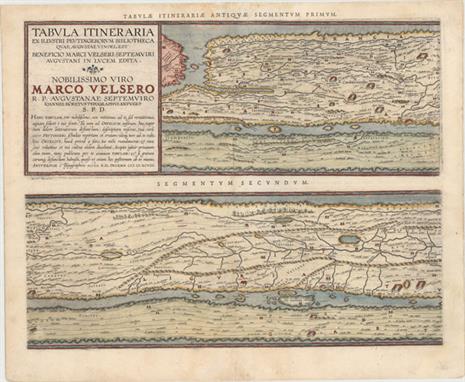
Ortelius, Abraham 1598 Tabula Itineraria ex Illustri Peutingerorum Bibliotheca…Nobilissimo Viro Marco Velsero "These four sheets are Ortelius` scarce version of the famous “Peutinger Table.” These decorative maps, in a sequence of four plates, each with two strip maps, depict the imperial roads and posts within the Roman Empire throughout Europe, North Africa and Asia as far as “Toprobana” (Sri Lanka). The format distorts the landmasses, but provides an excellent view of the cities and roads, which include distances between the posts. The three most important cities of the Roman Empire, Rome, Constantinople and Antioch, are represented by enlarged symbols including the emperor seated on a throne. Size given is for each plate. The original parchment document for this incredible map is thought to have been made in the thirteenth century. The original now resides in the Vienna National Library, but is so damaged that the Ortelius version is now the most reliable representation. The “Peutinger Table”, as it is generally known, derived its name from Konrad Peutinger, who once owned the original. Ortelius had manuscript copies made in 1598 from the original scroll and supervised the engraving, but did not live to see their publication. This is the Parergon edition with Latin text on verso, printed by Balthasar Moretus and published in 1624." 20.5" W x 15.5" H Watermarked paper with attractive color, light soiling, a faint damp stain along centerfold at top, and professional repairs to some centerfold separations. There are tears that enter map image 1" at bottom on 1st sheet, 2" at top on 2nd sheet, and 1/2" at bottom on 4th sheet that have all been professionally repaired.
![Hitchcock, Edward 1853 [Maps with Report] A Geological Map of the United States and Canada [and] Outline of the Geology of th](http://lot-images.atgmedia.com/SR/36385/2893812/122-2013117141232_468x382.jpg)
Lot 122
Hitchcock, Edward 1853 [Maps with Report] A Geological Map of the United States and Canada [and] Outline of the Geology of the Globe "The first map (24.2 x 16”) is Hitchcock`s landmark map of 1853. Essentially, it is a compilation of Lyell’s map for the eastern portion combined with M. Boue’s “Geological Map of the World” for the western portion modified by the author’s generalizations derived from the relations of geography to geology, as argued in the report. In this respect, he freely admits that such generalizations for the western US might be greatly erroneous. This map provides early detail of the geological formations. An explanatory key to the colors indicates fifteen geologic formations. The second map (23 x 18”) is drawn on Mercator`s Projection. It shows the entire world with a separate hemisphere of the “Supposed Antarctic Continent” that locates Wilke`s Land, South Victoria, Enderby Land and Cook`s sighting of 1774. This map uses six different colors to locate as many geological formations. Along the bottom are the comparative heights of mountains and volcanoes aligned with the position on the map. Condition: Clean and bright with original color, a short binding tear at left that just passes the neatline, a few small abrasions along the left portion of the image, and two tiny holes to the left of the explanatory key. These important geological maps are bound in the original report “Outline of the Geology of the Globe, and of the United States in Particular; with Two Geological Maps, and Sketches of Characteristic American Fossils,” by Edward Hitchcock, Boston: Phillips, Sampson & Company, 1853, 5.5 x 9”. First edition, octavo, 136 pp., 6 plates, and 2 folding hand-colored geological maps. In original blue blind stamped cloth with gilt title on spine. This work is notable for containing his first attempt at a geological map of the United States. His son C. H. Hitchcock also notes that “the part relating to the United States is the first attempt to show the distribution of rocks from the Atlantic to the Pacific border.” The report and it`s two maps are rarely seen together." #VALUE! Maps are clean and bright with original color. Covers show light wear and a few stains.

Lot 161
Mitchell, Samuel Augustus 1846 A New Map of Maryland and Delaware with Their Canals, Roads & Distances This is the rare Burroughs edition of this attractive map that carries nice detail of the counties, cities, roads and railways. A large inset of Baltimore includes a key to significant buildings. Across the top of the map is a table of Steam Boat Routes - from Baltimore to Norfolk, Baltimore to Philadelphia, and Baltimore to Washington with total and incremental mileage between stops. Mitchell obtained Tanner`s entire business and the production facilities and plates for Tanner`s New Universal Atlas. He first printed it under his name in 1846, retaining Tanner`s copyright notice on most of the maps. A second 1846 edition was then published using the imprint H.N. Burroughs. Nothing is known about Burroughs, but Ristow surmises he may have been an employee or associate of Mitchell`s. 14.3" W x 11.3" H Original color with a hint of toning.

Lot 197
Ringgold, Cadwalader 1852 A Series of Charts with Sailing Directions, Embracing Surveys of the Farallones, Entrance to the Bay of San Francisco ... State of California "This report and survey of the San Francisco Bay and associated headwaters was compiled by Cadwalader Ringgold, who had a long and distinguished naval career, including commanding the Porpoise in the Wilkes Exploring Expedition from 1838-1842 where he made his first surveys of the northwest coast of America. In 1849 he returned to California where he completed the work that resulted in the present volume, which was precipitated by the flood of emigration to the anchorage of San Francisco and on the unexplored routes leading to the interior. Ringgold`s set of maps served as an important pilot guide to the water routes leading to the “gold regions”. The six folding maps, all approximately 20 x 29 inches, include: a general chart of the San Francisco bay extending inland as far as Sacramento and Boston; detailed maps of some of the smaller harbors; and a chart of the Sacramento River from Suisun City to the American River. The list includes: 1. “General Chart Embracing Surveys of the Farallones Entrance to the Bay of San Francisco..” 2. “Sheet No. 1 - Chart of the Farallones and Entrance to the Bay of San Francisco...” 3. “Sheet No. 2 - Chart of the Bay of San Pablo...” 4. “Sheet No. 3 - Chart of the Suisun and Vallejo Bays..” 5. “Sheet No. 4 - Chart of the Sacramento River from Suisun City to the American River…” 6. “ Straits of Carquines and Vallejo Bay” [on sheet with] “Vallejo and Mare Island Strait” [and] “Anchorage off Sacramento City” [and] “Anchorage off San Francisco” [and] “Anchorage off New York of the Pacific” 48 pp., 8 plates and 6 large folding maps. Hardbound in brown embossed cloth with gilt title and illustration on front cover." 7.7" W x 11.5" H The condition code is for the maps, which are clean and bright with a 2" binding tear at left in each of the maps and very faint toning along a few folds. The text and plates are in good condition ("B") with scattered foxing. The hinges are starting, and the covers are worn, with the back cover partially detached.
![U.S. Army, 1866 [Lot of 2] Sketch of Vicinity of Fort Fisher… [and] Plan and Sections of Fort Fisher… "These](http://lot-images.atgmedia.com/SR/36385/2893812/236-2013117141551_468x382.jpg)
Lot 236
U.S. Army, 1866 [Lot of 2] Sketch of Vicinity of Fort Fisher… [and] Plan and Sections of Fort Fisher… "These maps are plates No. 5 and No. 6 from the report and are early published Civil War maps; most reports and maps withheld publication until the 1890`s to allow time for the national wound to heal sufficiently for a public discussion of the conflict. A. “Sketch of Vicinity of Fort Fisher Surveyed Under the Direction of Brvt. Brig. Gen. C.B. Comstock Chief Engineer”, (9.8 x 14.4”). Provides good detail of the peninsula, locating Ft. Buchanan, Mound Battery, Fort Fisher, headquarters, Wharf, Hospital, the Commissary and Fort Lookout to the north. Also locates the Wreck of the “Powder Vessel” some 830 yards north of Fort Fisher. B. “Plans and Sections of Fort Fisher Carried by Assault by the U.S. Forces Maj. Gen. A.H. Terry Commanding Jan. 15th 1865”, (15.3 x 10.6”). Very close detail of the Fort to show the position of all armament along the fortified walls. Locates cannon (“rifle”) locations including the huge Columbia 10” cannons at each end with many smaller (4.5” to 8”) cannons positioned between. The map shows Electric Wires leading out from the walls to a Line of Torpedoes protecting the open ground beyond the fort`s wall. It is quite rare to see this type of weapon mentioned on a map. Further research shows electrically triggered land-based torpedoes were used as early as during the Crimean War, 1854-1856." #VALUE! Issued folding with light toning along the folds.

Lot 342
Hondius/Blaeu, 1635 Peru Beautifully engraved map based on the cartography of Hessel Gerritsz. The map covers the Pacific coast of South America from Ecuador as far south as the Atacama Desert in the northern reaches of Chile. It includes the Potosi silver mines, Titicaca, Cusco, Quito and numerous other towns and villages. The dramatic strapwork cartouche incorporates both the title and the distance scales. A large compass rose orients the map with north to the left. It is further decorated with four Spanish galleons and three sea monsters. This is one of the plates that Blaeu acquired from the widow of Jodocus Hondius in 1629. French text on verso. 19.4" W x 14.9" H Original color on bright, watermarked paper with wide margins. There are professional repairs to a short centerfold separation and to a small hole to the right of the compass rose.

Lot 382
Hondius/Purchas, 1625 Romani Imperii Imago "A superb map of the Roman Empire covering most of Europe, Northern Africa, and the Near and Middle East. The map is richly decorated with two strapwork cartouches and two portraits. The cartouche in the lower section of the map contains a brief account of Roman dominion. On full sheet of English text (8.5 x 12.5”) with text on verso. At the beginning of the 17th century, Samuel Purchas, an English cleric, set out to publish a compendium of voyages to foreign countries. To illustrate his work, Purchase obtained the rights to use Jodocus Hondius` copperplates from “Atlas Minor”. Over 60 maps were included in “Purchas His Pilgrimes”, most of which were from Hondius` plates, with English titles inserted above them. Purchas also had a few additional maps engraved, including those for India, China, Greenland, North America, and Nova Scotia." 7.4" W x 5.9" H Light text show through with one small spot in the title cartouche and a few small damp stains confined to the blank margins.

Lot 486
Ortelius/Marchetti, 1598 Transilvania Attractive miniature map of Romania and Hungary and the surrounding region. The tiny map is filled with place names, each symbolized by a tiny castle and pictorial depictions of the mountainous countryside. Pietro Maria Marchetti produced the second pocket atlas based on Abraham Ortelius` folio "Theatrum". It is often referred to as the plagiarized version of the "Epitome". The copper plates are closely copied from those of Philip Galle`s 1593 Italian edition. On a full sheet of Italian text measuring 5.5 x 7.6". 4.1" W x 2.9" H Watermarked paper with marginal soiling and a light damp stain along bottom edge of sheet.

Lot 493
Ortelius/Marchetti, 1598 Slavoniae, Croatiae, Carniae, Istriae, Bosniae, Descri. Lovely miniature map of northeastern section of the Balkans - present day Slovenia and Croatia with the Adriatic Sea located at the lower left. The map is filled with tiny cities and good detail of the rivers systems. Pietro Maria Marchetti produced the second pocket atlas based on Abraham Ortelius` folio "Theatrum". It is often referred to as the plagiarized version of the "Epitome". The copper plates are closely copied from those of Philip Galle`s 1593 Italian edition. On a full sheet of Italian text measuring 5.6 x 7.6". 4" W x 2.8" H Watermarked paper with marginal soiling and light show-through of text on verso.

Lot 501
Ortelius/Marchetti, 1598 Corcyra vel Corfu Miniature map of this important Greek island, handsomely adorned with a sailing ship and a sea monster. Pietro Maria Marchetti produced the second pocket atlas based on Abraham Ortelius` folio "Theatrum". It is often referred to as the plagiarized version of the "Epitome". The copper plates are closely copied from those of Philip Galle`s 1593 Italian edition. On a full sheet of Italian text measuring 5.5 x 7.5". 4.1" W x 2.9" H Watermarked paper with marginal soiling and minor show-through of text on verso.

Lot 518
Ortelius/Marchetti, 1598 Ischia Ins Charming miniature map of this Italian island famous for its therapeutic baths. The map is oriented with north to the bottom, and towns are depicted as tiny castles. Pietro Maria Marchetti produced the second pocket atlas based on Abraham Ortelius` folio "Theatrum". It is often referred to as the plagiarized version of the "Epitome". The copper plates are closely copied from those of Philip Galle`s 1593 Italian edition. On a full sheet of Italian text measuring 5.5 x 7.5". 3.9" W x 2.7" H Watermarked paper with marginal soiling and minor show-through of text on verso.
Lot 519
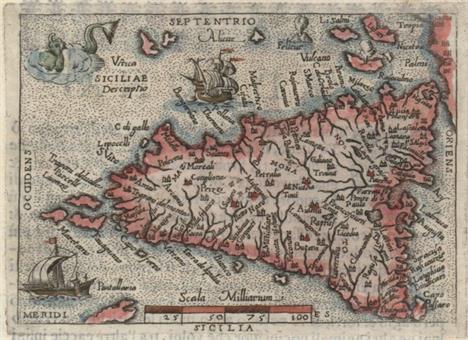
Ortelius/Marchetti, 1598 Siciliae Descriptio This great little miniature map shows rivers, lakes, and many towns on the island of Sicily. The stipple sea is adorned with a sailing ship, a galley, a sea monster, and an erupting volcano. Pietro Maria Marchetti produced the second pocket atlas based on Abraham Ortelius` folio "Theatrum". It is often referred to as the plagiarized version of the "Epitome". The copper plates are closely copied from those of Philip Galle`s 1593 Italian edition. On a full sheet of Italian text measuring 5.5 x 7.5". 4.1" W x 2.9" H Watermarked paper with marginal soiling and minor show-through of text on verso.

Lot 534
Ortelius/Marchetti, 1598 Malta Olim Melita Insula Charming miniature map of Malta with towns depicted with castles. The map is richly adorned with a sea monster, sailing ship, and the Apostle Paul`s shipwreck depicted off the northern coastline, with two swimming survivors and several onlookers on land. Pietro Maria Marchetti produced the second pocket atlas based on Abraham Ortelius` folio "Theatrum". It is often referred to as the plagiarized version of the "Epitome". The copper plates are closely copied from those of Philip Galle`s 1593 Italian edition. On a full sheet of Italian text measuring 5.5 x 7.5". 4.1" W x 2.9" H Watermarked paper with marginal soiling and minor show-through of text on verso.

Lot 536
Ortelius/Marchetti, 1598 Cyprus Insula This tiny map is a charming depiction of the island showing the rivers and cities. The island is surrounded by sailing ships and a sea monster. Pietro Maria Marchetti produced the second pocket atlas based on Abraham Ortelius` folio "Theatrum". It is often referred to as the plagiarized version of the "Epitome". The copper plates are closely copied from those of Philip Galle`s 1593 Italian edition. On a full sheet of Italian text measuring 5.5 x 7.5". 4.1" W x 3" H Watermarked paper with marginal soiling and minor show-through of text on verso.

Lot 539
Ortelius/Marchetti, 1598 Candia Olim Creta Beautifully and fully engraved copper plate map features exceptional detail of the island. The map has numerous place names and is embellished with a full stipple sea that has two sailing ships and a vigorous sea monster. Shows the mythological Labyrinth where the Minotaur was confined. Pietro Maria Marchetti produced the second pocket atlas based on Abraham Ortelius` folio "Theatrum". It is often referred to as the plagiarized version of the "Epitome". The copper plates are closely copied from those of Philip Galle`s 1593 Italian edition. On a full sheet of Italian text measuring 5.5 x 7.5". 4.1" W x 2.9" H Watermarked paper with marginal soiling and minor show-through of text on verso.

Lot 541
Ortelius/Marchetti, 1598 Sardinia This charming miniature map delineates all of Sardinia and part of Corsica. North is oriented to the left. The stipple engraved sea is embellished with a sailing ship and sea monster. Pietro Maria Marchetti produced the second pocket atlas based on Abraham Ortelius` folio "Theatrum". It is often referred to as the plagiarized version of the "Epitome". The copper plates are closely copied from those of Philip Galle`s 1593 Italian edition. On a full sheet of Italian text measuring 5.5 x 7.5". 4.1" W x 2.9" H Watermarked paper with marginal soiling and minor show-through of text on verso.
![Hondius/Purchas, 1625 [Lot of 3] Barbaria [and] Congi Regnu [and] Guinea "At the beginning of the 17th century, Purchas,](http://lot-images.atgmedia.com/SR/36385/2893812/655-2013117142919_468x382.jpg)
Lot 655
Hondius/Purchas, 1625 [Lot of 3] Barbaria [and] Congi Regnu [and] Guinea "At the beginning of the 17th century, Purchas, an English cleric, set out to publish a compendium of voyages to foreign countries. To illustrate his work, Purchase obtained the rights to use Jodocus Hondius` copperplates from “Atlas Minor”. Over 60 maps were included in “Purchas His Pilgrimes”, most of which were from Hondius` plates, with English titles inserted above them. This lot features three regional maps of Africa from this publication. Each is on a full sheet of English text (8.0 x 12.5”) with text on verso. A. “Barbaria”. Includes two smaller maps below showing Carthage and the Nile Delta. Condition: There are a few light spots and a small horizontal extraneous crease. (B) B. “Congi Regnu”. Condition: Light damp stains in the text below the map, away from the image. (A) C. “Guinea”. Includes an inset of St. Thomas. Condition: Light soiling with an extraneous crease along the left side of the image. Narrow left margin, as issued. (B+)" 7" W x 5.7" H See description.

Lot 701
Audubon, J. J. 1860 Smew or White Nun, Mergus Albellus "This original chromolithograph is Plate 414 from the double-elephant folio Bien edition of Audubon’s great work on American ornithology. Audubon traveled throughout the U.S. and recorded 435 life-size images of every native bird in the country, depicting them in natural poses in their native habitats. This handsome engraving depicts a male Smew in flight with a female in the water below, with cliffs filling the landscape behind them. Audubon procured a male specimen himself at Lake Barataria (outside of New Orleans) circa 1821 and made a drawing on the spot. Although Audubon recognized that the Smew was not an American species, he decided to include it in his “Birds of America” as the duck was known to make occasional (and potentially accidental) visits to the U.S. The full sheet measures 25.5 x 39.9”. Julius Bien was among the pioneers in developing chromolithography (an early form of color printing) in the United States. The Bien edition was initiated by John Woodhouse Audubon, the younger of the two Audubon sons. Originally conceived to be a full reissue of the 435 images in 44 parts consisting of ten images each, the project was discontinued in 1860 after only 15 parts had been issued. As a result, these plates are even rarer than the first “Birds of America” edition." 19.8" W x 25.8" H Vivid color with a few tiny, unobtrusive spots in image and very light marginal soiling. There are several expertly repaired tears all confined to the blank margins and far from image. Professionally backed in Japanese tissue.

Lot 707
Hollar, Wenceslaus 1794 Dispone Domui Tuae Morieris Enim Tu, & Non Vives... This copperplate engraving comes from the fascinating work based upon Holbein`s original 15th century designs. Wenceslaus Hollar, a Bohemian etcher, created the copper plates for the original publication in 1647. The plates then disappeared until the late 18th century, when several editions from the "newly discovered" plates began to appear. Although the traditional Dance of Death goes back to the Middle Ages, Hans Holbein altered the medieval concept to show the omnipresence and universality of death. This plate shows Death confronting an Emperor. The text beneath the image comes from Isaiah 38:1, and translates to: "Take order with thy house, for thou shalt die, and not live." 2.1" W x 2.7" H This example is on sturdy paper with just a touch of foxing in the sizable margins.

Lot 748
Anon., 1759 The Gentleman`s Magazine, and Historical Chronicle "This lot includes 9 individual monthly issues (missing May, October and November) and the supplement from 1759 during the heart of the Seven Years War. All maps and plates are present for the monthly issues included. The eight maps, all listed in Jolly, include: A. “Compleat Map of Germany Comprehending in One View the Different Seats of the Present War” (11 x 13.3”). B. “A Map of Martinico, from the Latest and Best Authorities”, by John Gibson (7.5 x 9.5”). C. “The Roads, of Toulon, with the Adjacent Country” (8 x 10.5”). D. “A Map of the Seat of War on the Rhine, and Part`s Adjacent, in Germany, 1759” (7.3 x 10”). E. “A New and Accurate Map of the Isles of Guadaloupe, Marie-Galante &c. from the Best Authorities”, by John Gibson (4.8 x 11.5”). F. “Plan of Have de Grace [on sheet with] The Bombardment of Have de Grace July 4th 1759 [and] [Untitled - English Channel]” (7.5 x 10”). G. “A Map of That Part of Westphalia, in which the French Army Where [sic] Defeated Aug. 1. 1759” (4.3 x 7.3”). H. “A Map of Pomerania and Brandenburg with the Frontiers of Poland” (7.5 x 10.3”). Disbound, 8vo." 5.3" W x 8.3" H The maps and plates are good to very good with light to moderate toning and occasional light offsetting. Disbound.

Lot 752
Wilson, Adrian 1978 The Making of the Nuremberg Chronicle Detailed examination of the making of this important early illustrated book taken from surviving page layouts, original contracts for the illustrations, contracts for printing, etc. It includes a history of the printer, Anton Koberger, and a list of known copies of the first Latin and German editions. The text of this study of the Chronicle`s production combines scholarship with wit, providing a fascinating view of the incunabula period. Introduction by Peter Zahn and published by Nico Israel, 253 pp., illustrated, including color plates. First edition, second printing. Hardbound in gray cloth, pictorial dust jacket. 10" W x 13.8" H


Lot 149A
BRITTON, John. The History and Antiquities of the Cathedral Church of Worcester, pub. Longman, Rees, Orme, Brown, Green, 1835. Large Paper edition. First Edition. 4to. Pp xxxii, 32, 18. Frontis engraved and printed title pages, and 14 plates (16 plates in all). Bound in half leather with recent matching spine with original label.
Lot 255
Sitwell S., Buchanan H. and Fisher J. . Fine Bird Books 1700-1900. Folio. Pp.104, 16 col. plates, 1 folding, 24 collotype plates, Ltd. 2000 copies. Original cloth marbled boards: Dustjacket incomplete. and Mitchell, F.S The Birds Of Lancashire. London: John van Voorst. 1885.First edition. 2 coloured lithographs. 13 other illustrations, folding map and vignettes. green cloth, gilt titles. (2)
Lot 261
LABEDOYERE, Count Memoirs of the Public and Private Life of Napoleon Bonaparte; with historical illustrations and original anecdotes from the Ms. of Count Labedoyere … preceded by an interesting analysis of the French Revolution. London: George Virtue. 1837. First edition. Volume 1 of 2 volumes. Pp. vii, 402. 5 hand coloured engraved plates. Half leather with black labels, rubbed and CRUIKSHANK, George (Illus.) (1792-1878). The History of Napoleon Buonaparte : Reprinted from the "Family Library" illustrated by George Cruikshank. London: William Tegg. 1866. Pp. xx, 655. A very good copy in the original gilt-blocked full red cloth with gilt decoration. and KELLY, Christopher .Battle of Waterloo. 4to. 1817 with map. full leather. as seen. and one other (4)
Lot 263
MONTGOMERY, James. Journal of Voyages and Travels - by Daniel Tyerman & George Bennet - deputed from the London Missionary Society - to visit their various stations in the South Sea Islands, China, India &c between the years 1821 and 1829 - in two volumes. Frederick Westley and A.H. Davis, London, 1831 First Edition. 2 volumes. xxiv, 566 and viii, 568 pages. Fourteen b/w engraved plates, including the frontispieces. Rebound at some time in half leather with marbled boards. (2)
Lot 270
HOLME, Charles The Old Water - Colour Society 1804-1904 London: Offices Of The studio 1905. 40 plates. and NA BARBIZON HOUSE 1935: An Illustrated Record. (SIGNED). London: Lockett Thomson 1935. Limited edition, No 199 Signed with compliments to Professor Henry Tonks by Lockett Thomson. volumes for 1931, 1933, 1934, 1937. (6)
Lot 275
T Simpson, Ch Alison Sutton, M.A.F. (ed) Golf Courses: Design, Construction And Upkeep, London: Simpkin Marshall 1933. First edition. small 4to Pp.xv 152. [viii adverts] plus 48 pages of photographic plates, tables in text and to appendix. Original green cloth with gilt titles. Spine worn. Scarce. and VAILEE, P.A. Modern Golf. London: Adam and Charles Black. 1909. Containing one hundred full-page illustrations from photographs and fifty-six diagrams. First edition. Pp.,xiv, [2] contents, 252. Blue cloth with gilt titles.
Lot 359
Heath Robinson (2 items) Perrault, Master Charles w/trans. by A. E. Johnson Old-Time Stories London : Constable 1921. 4to. First edition. Pp. xi, 200. 6 cold plates. 43 black and white drawings. Red cloth with gilt titles. Spine underlayed. and Kipling, Song of the English. Illust. Heath Robinson. Hodder & Stoughton. 4to. Original binding. excellent. 18 of 30 plates present. (2)


-
483769 item(s)/page