![Praga, Bohemiae Metropolis Accuratissime Expressa [on sheet with] Egra Urbs a Fluvio, Cui Adiacet, Dicta, Olim Imperio Roman](http://lot-images.atgmedia.com/SR/36385/2916721/530-2014116144622_468x382.jpg)

Praga, Bohemiae Metropolis Accuratissime Expressa [on sheet with] Egra Urbs a Fluvio, Cui Adiacet, Dicta, Olim Imperio Romano... At top is a panoramic view of the Bohemian capital of Prague situated on the banks of the River Vltava and surrounded by verdant hillsides of the Vltava Valley. The three distinct sections of the city are visible in the view: the Stare Mesto (Old Town) surrounding the Vysehrad (high castle), the Nove Mesto (New Town), and the Mala Strana (Lesser Quarter) clustered around the Prague Castle. The Charles Bridge connects the Mala Strana to the Nove Mesto. Much of this development dates from the reign of Charles IV (1346-78) when Prague was the capital of the Holy Roman Empire and the most important city in central Europe. Below is a view of the city of Cheb, on the River Eger, from which the town derived its original name. The Imperial Palace dominates the view. French manuscript text on verso. A nice impression on watermarked paper with attractive color, light soiling, and several short printer`s creases. There is a dark pencil line in left blank margin and several tiny holes, all away from image. 13.2"" W x 18.6"" H Braun & Hogenberg, 1575
We found 9689 price guide item(s) matching your search
There are 9689 lots that match your search criteria. Subscribe now to get instant access to the full price guide service.
Click here to subscribe- List
- Grid
-
9689 item(s)/page

Plan de la Ville de Meaco Attractive plan of the city of Kyoto when it was the capital of the country. The block pattern of the city is laid out and is encircled by the Kamo River. Engraved by Guillaume Dheulland and decorated by a compass rose with north oriented to the left. Issued folding with very faint offsetting and a binding trim at right that has been replaced with old paper. 7.7"" W x 10.9"" H Bellin, Jacques Nicolas 1760

Johnson`s New Illustrated Family Atlas, with Physical Geography, and with Descriptions Geographical, Statistical, and Historical... This complete atlas contains 55 beautifully rendered maps, including 47 double-page maps. There are several thematic maps and diagrams interspersed throughout the text that display the geology, weather, tides, agriculture, flags and animal kingdoms of the world. The steel-engraved frontispiece is a lovely view of the US Capitol. This atlas also features the double-page Civil War map Vicinity of Richmond.This edition includes the Southwest map depicting the original four counties of Yavapai, Mohave, Yuma, and Pima in the newly organized Arizona Territory, with Prescott as the capital. The Utah/Nevada border is now at 114° and Arizona and Nevada have their final borders. Early historical details include the Pony Express and United States Mail routes, the emigrant roads to California, and the proposed southern railroad route.The double-page map of Texas shows county development mostly in eastern Texas and only the four large counties of Young, El Paso, Presidio and Bexar in the west. The panhandle, noted as the Staked Plains without Wood or Water, includes a large section that is unorganized. There is nice depiction of the wagon roads, many named, with several completed railroads. The inset maps are `Northern part of Texas` and `Plan of Galveston Bay.` The double-page map of `Nebraska, Dakota, Idaho and Montana` shows a very early rendering of Wyoming Territory, organized in 1868. Idaho is shown taking up the present-day Wyoming region south of Jackson Hole. With the exception of the southwestern border, Montana is correctly formed which, along with Wyoming, was previously contained in a large Idaho territory. Dakota Territory, from which Wyoming was formed, remains undivided. There is excellent detail throughout with scores of place names, roads, watershed, topography, the Emigrant Road, forts, springs, routes of exploration and proposed railroads. The route of the Pony Express & U.S. Mail Route through Utah, Wyoming and Nebraska is delineated.Folio. 137 pp., frontispiece, 55 maps, and 5 charts depicting mountains and rivers of the world, flags, universal time, and coats of arms. Hardbound in original quarter leather with tips and green cloth, embossed covers with gilt titles on cover and spine, marbled pastedowns. The maps are all in very good to near fine condition with bright original color, light toning around sheet edges, occasional spots of foxing, and minor offsetting on a few maps. Four double-page maps have long centerfold separations that have been closed on verso with archival tape, and the map of New York State has a 4"" tear along the centerfold that has also been closed on verso with archival tape. The binding is sound. The front and back free-endpapers have been removed, and the last page in the atlas is partially detached. The covers and spine show moderate wear. 18.6"" W x 14.8"" H Johnson, A. J. 1867

Map of North America Designed to Accompany Smith`s Geography for Schools An early example of this copper engraved map that shows the United States with a population of 17 million people. The Independent Republic of Texas with Austin as its capital is prominently featured. The entire western region is mostly unsettled with only a few place names including St. Francisco, Monterrey, St. Diego and Albuquerque. In the vicinity of Santa Barbara is St. Louis, a name we`ve not see on any other map. Alaska is a large blank area labeled Russian Possessions with the notation Unexplored Region, and Canada is labeled New Britain as well as British America. In the Northwest, the U.S. extends well up into Canada to the 55th parallel, an early indication of the tensions between the United States and Britain in their claims in the region. Mexico controls the entire Southwest and California up to the 42nd parallel. The Great Basin area is shown as the huge Great Sandy Plains, and the Great Salt Lake is too far to the east and simply called Salt L. The map extends to include Greenland, Central America and the Caribbean. Minor soiling primarily confined to the blank margins. 10.4"" W x 8.7"" H Burgess, Daniel 1839
![[Lot of 2] A New Map of Tennessee with its Roads and Distances from Place to Place Along the Stages & Steam Boat Routes](http://lot-images.atgmedia.com/SR/36385/2916721/174-2014116143556_468x382.jpg)
[Lot of 2] A New Map of Tennessee with its Roads and Distances from Place to Place Along the Stages & Steam Boat Routes [and] A New Map of Kentucky with its Roads & Distances from Place to Place Along the Stage & Steam Boat Routes A. A New Map of Tennessee with its Roads and Distances from Place to Place Along the Stages & Steam Boat Routes, dated 1841 (14.4 x 10.5""). This is the uncommon Tanner issue of this map; one of the few 19th century maps to show Tennessee alone. The map is inset with the regions surrounding both Nashville and Knoxville at the top, and the steamboat routes all the way to New Orleans are noted in a table to the right. Samuel Augustus Mitchell, and then Thomas, Cowperthwait & Co. purchased the plates for their editions of the Universal Atlas, but it is the earlier Tanner editions that are much more sought after. B. A New Map of Kentucky with its Roads & Distances from Place to Place Along the Stage & Steam Boat Routes, dated 1839 (13.0 x 10.7""). This highly detailed map of Kentucky illustrates roads and distances along the stage and steamboat routes. Canals, railroads, the state capital, county towns and leading roads are noted. Includes insets of Falls of Ohio, the vicinity of Clarksburg and Maysville, and the vicinity of Lexington. This is one of a few 19th century maps to show Kentucky without Tennessee. Original color with a few minor spots in the image and light toning along sheet edges. See description Tanner, Henry Schenck 1839-41
![[Lot of 2] Asher & Adams` Colorado [and] Asher & Adams` Utah A. Asher & Adams` Colorado. Double-page map shows](http://lot-images.atgmedia.com/SR/36385/2916721/190-2014116143623_468x382.jpg)
[Lot of 2] Asher & Adams` Colorado [and] Asher & Adams` Utah A. Asher & Adams` Colorado. Double-page map shows Colorado just prior to statehood. County configurations are current to 1870 with the addition of Bent and Greenwood from Las Animas in the southeast. The map displays major rivers, railroads and the progress of public surveys. A note along the Colorado/Utah border states ""elevated plain, fertile, gently rolling, fresh water lakes and timber."" B. Asher & Adams` Utah. Another double-page map focused on Utah but including parts of Wyoming, Colorado and Nevada. 18 counties are noted and Salt Lake City is shown as the capital. Development is confined from the Salt Lake area down to the southwest corner along the Salt Lake, Sevier Valley and Pioche Railroad. The completed Central/ Union Pacific Railroad is shown going from Wyoming through Utah into Nevada with some spur lines going into central and northern Utah. Light scattered foxing with faint offsetting of the titles. 16.4"" W x 22.6"" H Asher & Adams, 1874


A CHINESE GOLD AND SILVER THREAD EMBROIDERED `DRAGON` SUITE consisting of two heart-shaped pouches (3"" long), a chopstick case of tapering form, (12"" long), a gourd-shaped pouch (6"" long), a rectangular case with sliding inner compartment (5"" long), a folding square pocket (3.5""), and a ruyi-shaped picture case, (3.5"" across), most pieces with tassels, each worked with dragons among cloud scrolls above waves, late Qing (7). Provenance: Thomas Child (1841-1898), and thence by descent. Thomas Child was a well-known photographer who produced an album ""Views of Peking"" in 1877. He also lived and worked in the Capital as a Gas Engineer Inspectorate General from 1871-1889. The family have always understood that he had links with the Imperial household and that this fine suite of embroidery was a gift to the Child family from the Emperor.

A Pair of George III Silver Chambersticks, Samuel Whitford II, London 1801, circular with gadrooned border to the pan, nozzle and extinguisher, the pan engraved with a coat of arms, the nozzle and extinguisher with a crest, 10cm high, 20oz all in (6) All marks match - engraved No.1 and No.3 to base along with a scratch weight. Engraved arms showing signs of wear. No.1 - capital split at top of border very slightly, holder for extinguisher worn. No.3 - as per above but no split. All marks are clear and readable. Several dents to both extinguishers.

A 5`` Bronze Sun Dial, possibly dated 1660, on a sandstone fluted column with scroll capital and rough carved base, 142cm high overall Provenance: thought to be the sundial erected by Robert Towneley in 1662 at Carr Hall, Barrowford. For further reading see Blakey (Jesse) The Annals and Stories of Barrowford, pg.193, para.3 which refers to a sundial Gnomon missing and extensive weathering. 190214
A Pair of George III Silver Chambersticks, Samuel Whitford II, London 1801, circular with gadrooned border to the pan, nozzle and extinguisher, the pan engraved with a coat of arms, the nozzle and extinguisher with a crest, 10cm high, 20oz all in (6) All marks match - engraved No.1 and No.3 to base along with a scratch weight. Engraved arms showing signs of wear. No.1 - capital split at top of border very slightly, holder for extinguisher worn. No.3 - as per above but no split. All marks are clear and readable. Several dents to both extinguishers.
A 5`` Bronze Sun Dial, possibly dated 1660, on a sandstone fluted column with scroll capital and rough carved base, 142cm high overall Provenance: thought to be the sundial erected by Robert Towneley in 1662 at Carr Hall, Barrowford. For further reading see Blakey (Jesse) The Annals and Stories of Barrowford, pg.193, para.3 which refers to a sundial Gnomon missing and extensive weathering. 190214

A Luftwaffe Forestry dress bayonet, blade 8 in. and double edged for the last 2 1/2 in., marked `Waffen-Loesch Berlin` and `Ch. A.W.`, capital `H` stamped to the spine, small oval crosspiece numbered `474` and `270`, steel scabbard. See general disclaimer on Third Reich items. Live bidding available, see www.georgekidner.co.uk for details

A late Victorian silver candlestick by Goldsmiths & Silversmiths Co., London 1895, with a circular beaded sconce, an urn shaped capital, a tapering stem and on a canted square base, embossed with foliate swags, ram`s heads and urns, 19.5cm high, loaded; another late Victorian candlestick by Goldsmiths & Silversmiths Co., London 1900, 12cm high, loaded; a rectangular engine turned cigarette case by Frederick Field, Birmingham 1933, 11.5cm long; and a pair of Edwardian knife rests, London 1903, with twisted rests and pierced ends, 8cm long, 254g (8.15 oz) gross weighable. A condition report is not available on this lot.


A good quality Victorian bracket clock in figured walnut case with canted corners with ionic capital mounts, pierced brass side panel and further applied brass work detail enclosing a rectangular brass clock face with silvered dial and regulator enclosing a two train movement - Manoah Rhodes & Sons Ltd, Bradford, 36 cm tall approx

A good quality Victorian bracket clock in figured walnut case with canted corners with ionic capital mounts, pierced brass side panel and further applied brass work detail enclosing a rectangular brass clock face with silvered dial and regulator enclosing a two train movement - Manoah Rhodes & Sons Ltd, Bradford, 36 cm tall approx

Poster, BR `Inverness - The Capital of the Scottish Highlands` by Lance Cattermole, quad royal size 40" x 50". A vibrant image of the Queen`s own Cameron Highlanders marching along Ness Walk. Published by BR Scottish Region and printed by The Baynard Press. Mounted on linen, very good condition throughout except for a small repair bottom left corner.


Pre-Columbian Ceramic Three-Chambered Vessel Chimu culture, 1000-1470 AD. A burnished black ware vessel with funicular neck, conical base and body formed as three chambers with pierced lugs to the shoulders; the body with three lozengiform panels, bilinear border and pelletted detail. 500 grams, 16.5 cm (6 1/2"). Ex Hiller collection, Essex, UK; acquired in the 1950s-1960s. The Chimu built a capital at Chan Chan, just north of Trujillo. Chan Chan is the largest pre-Columbian city in Peru, covering about 28 sq km, and is estimated to have housed about 50,000 people. Gone, for the most part, is the technique of painting pots. Instead, they were fired by a simpler method than that used by the Moche, producing the typical blackware seen in many Chimu pottery collections. Despite its poorer quality, this pottery still shows us life in the Chimu kingdom. Although the quality of the ceramics declined, metallurgy developed and various alloys, including bronze, were worked. The Chimu were also exceptionally fine goldsmiths. It is as an urban society that the Chimu are best remembered. Their huge capital contained approximately 10,000 dwellings of varying quality and importance. Buildings were decorated with friezes, the designs molded into the mud walls, and the more important areas were layered with precious metals. There were storage bins for food and other products from their empire, an empire which stretched along the coast from the Gulf of Guayaquil to Chancay. There were huge walk-in wells, canals, workshops and temples. The royal dead were buried in mounds with a wealth of funerary offerings. The Chimu was a highly organised society - it must have been to have built and supported a city such as Chan Chan. Chimor was conquered 50 years before the arrival of the Spanish, so there were plenty of survivors from pre-Inca times to dictate the particulars of the daily life of the Chimú before their conquest by Inca Tupac Inca Yupanqui. Chimor grew out of the remnants of the Moche culture. TimeLine Auctions Ltd arranges printed catalogue rostrum Auctions, eAuctions and Timed Auctions where we offer antiquities, ancient artefacts / artifacts, antiques, collectibles, coins, medals and books for public sale. Fine condition, base chipped.


1913 official UNDERGROUND MAP OF LONDON, "What to see and how to see it". This is the map shown on p59 of Capital Transport's "No need to ask" reference work and shows the planned extensions of the Bakerloo, Central and Hampstead Tubes. The cover features one of the first printed versions of the bullseye logo, forerunner of today's roundel. This is a scarce issue and is in very good condition, minor ageing only. [1] See also lot 96.

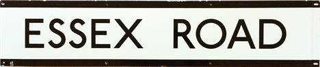
London Underground 1950s/60s ENAMEL STATION FRIEZE PLATE for Essex Road in the black of the Northern Line. Opened in 1904 by the Great City & Northern Rlwy, Essex Road was part of the Underground from 1933-1975 when it was transferred to British Rail. Today is it operated by First Capital Connect. Some small chips at the edges, otherwise in very good condition. [1]


A ROLEX OYSTER PERPETUAL DATE ADJUSTABLE GENTLEMAN`S OFFICIALLY CERTIFIED CHRONOMETER, having two-tone steel and gilt case and integral bracelet, diamond bezel and diamond set chapter on black dial, serial no. 8982789, together with instruction book, red seal and certificate from Capital Midland Fine Watches, in case, (two loose links and an insurance certificate dated 31.1.14)


INDIA - LAHORE GUIDE - Lahore, Capital of the Punjab, A Guide to Places of Interest, with History and Map, by H.A. Newell, 1921, second edition, 80pp, cloth; Report of the Revised Settlement of Muktsar Proper and on the First Regular Settlement of Ilaka Mamdot in the Ferozepore District of the Lahore Division, by L.S. Saunders, C.A. Roe and W.E. Purser, 1878, first edition, 39pp, original cloth. (2)

INDIA - HISTORY OF KARACHI - Kurrachee: Past, Present, And Future, by Alexander F. Baillie, 1890, 269pp, original cloth. A fine study and history of this port city now in Pakistan, with 11 illustrations and numerous maps and plans of the city. Karachi is the capital of Sindh as well as the largest and most populous metropolitan City of Pakistan and was the capital of Pakistan until Islamabad was constructed as a capital. After some exploratory missions to the area, the British East India Company captured the town when HMS Wellesley anchored off Manora island on 1 February 1839. Two days later, the little fort surrendered. The town was later annexed to British India when Sindh was annexed by Major General Charles James Napier at the Battle of Miani on 17 February 1843.

INDIA - LAWRENCES OF PUNJAB - The Lawrences Of The Punjab, by Frederick P. Gibbon, 1908; Lahore (Capital of Punjab), A Guide To Places Of Interest With History And Map, by Lt Col H.A. Newell; Lahore Guide And Directory, by D.C. Khosla, Third Edition revised and enlarged; Punjab Past And Present, by Editor Ganda Singh, 1968, Vol 2 Part 1. (4)

INDIA - TRAVELLERS TO PUNJAB - The Punjab a Hundred Years Ago, Punjab Government Record Office Publications, Monograph No. 18; as described by V. Jacquemont (1831) and A. Soltykoff (1842), Trans. and ed. by H.L.O. Garrett, 1935, first edition, 131pp, original boards. Prince Soltykoff was a Russian artist and traveller in Persia and India. He ended up making two voyages in 1841-43 and 1844-46, and achieving the sobriquet `The Indian` from the Russian and French aristocracy. In 1849 he published a selection of his letters in French accompanied by his drawings, which became very well known in Europe "Lettres sur L`Inde". Paris, 1848. In 1851 the book was translated into Russian and became an instant success: it truly enraptured the Russian reading public. Jacquemont was a French botanist and geologist. Jacquemont travelled to India in 1828, and remained there for the rest of his life. He visited Amber in Rajputana, met with the Sikh Emperor Ranjit Singh at his capital of Lahore, and visited the kingdom of Ladakh in the Himalaya. He also visited Bardhaman in Bengal in November 1829. He died of cholera in Bombay on December 7, 1832.

PRESENTATION COPY OF THE HISTORY OF SIMLA - Simla, Past and Present, by Edward J. Buck, second edition, 342pp, original pictorial cloth, Signed presentation inscription from the author. A most fascinating study of the popular Punjab Hill Station, which became the summer capital of the British Empire. Two maps, one folding to the front and with numerous photographic illustrations.

INDIA - PUNJAB HILL STATION OF SIMLA - Simla Past and Present, by Edward J. Buck, First Edition 1904, 270pp, rebound. A most fascinating study of the popular Punjab Hill Station, which became the summer capital of the British Empire. Two maps, one folding to the front and with numerous photographic illustrations. Rare.


-
9689 item(s)/page