We found 1765 price guide item(s) matching your search
There are 1765 lots that match your search criteria. Subscribe now to get instant access to the full price guide service.
Click here to subscribe- List
- Grid
-
1765 item(s)/page

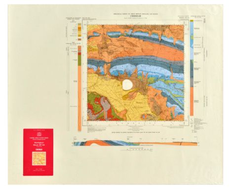
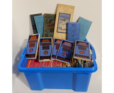
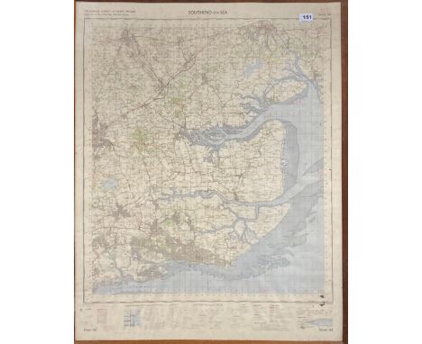
Lot 231
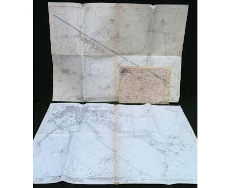
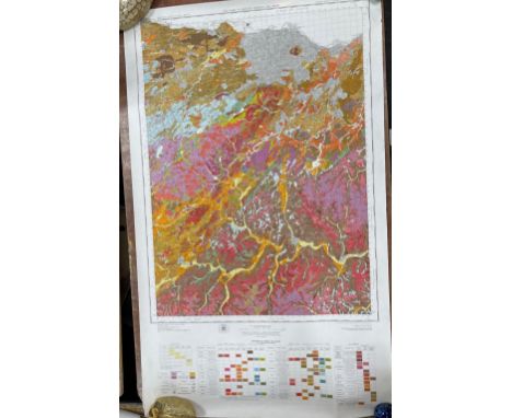
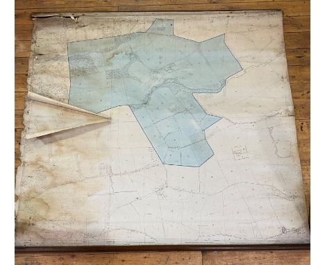
Set of 9 original vintage Ordnance Geological Survey maps of various areas of Great Britain. 1. Sanquhar, Scotland map featuring a map of the area with geological signs and colours. Published in colour by the Director General at the Ordnance Survey Office, Southampton 1937. Horizontal. Very good condition, minor creasing, minor staining. Country of issue: UK, designer: unknown, size (cm): 63x89, year of printing: 1937; 2. Newport Geological Survey of Great Britain (England & Wales) featuring a map of the area marked in different colours to portray the rocks. Published by the Director General at the Ordnance Survey Office, Southampton 1969 for the institute of geological sciences. Horizontal. Good condition, creasing, tears on edges. Country of issue: UK, designer: unknown, size (cm): 55x85, year of printing: 1969; 3. Merthyr Tydfil Geological Survey of Great Britain (England & Wales) featuring the map of the area in different colours marking various rock formations. Published by the Director General at the Ordnance Survey Office, Chessington, Surrey, 1957 for the Geological Survey. Horizontal. Very good condition, minor creasing, minor staining. Country of issue: UK, designer: unknown, size (cm): 63x89, year of printing: 1957; 4. Abergavenny Geological Survey of Great Britain (England & Wales) featuring the map of the area in different colours marking various rock formations. Published by the Director General at the Ordnance Survey Office, Chessington, Surrey, 1957 for the Geological Survey. Horizontal. Very good condition, minor creasing, minor staining, small tears. Country of issue: UK, designer: unknown, size (cm): 64x90, year of printing: 1958; 5. Cheddar Geological Survey of Great Britain (England & Wales) featuring the map of the area in different colours marking various rock formations. Horizontal. Good condition, creasing, staining, Country of issue: UK, designer: unknown, size (cm): 75x90, year of printing: 1976; 6. Moreton in Marsh Geological Survey of Great Britain (England & Wales) featuring the map of the area in different colours marking various rock formations. Published by the Director General at the Ordnance Survey Office, Southampton for the Institute of Geological Sciences. Horizontal. Good condition, minor creasing, staining. Country of issue: UK, designer: unknown, size (cm): 63x89, year of printing: 1975; 7. Pontypridd Geological Survey of Great Britain (England & Wales) featuring the map of the area in different colours marking various rock formations. Horizontal. Good condition, creasing, small tears. Country of issue: UK, designer: unknown, size (cm): 89x100, year of printing: 1975; 8. Church Stretton Geological Survey of Great Britain (England & Wales) featuring the map of the area in different colours marking various rock formations. Horizontal. Good condition, creasing, tears, minor staining. Country of issue: UK, designer: unknown, size (cm): 89x100, year of printing: 1974; 9. Sanquhar Geological Survey of Great Britain (Scoltand) featuring the map of the area in different colours marking various rock formations. Horizontal. Very good condition, creasing. Country of issue: UK, designer: unknown, size (cm): 63x89, year of printing: 1971.
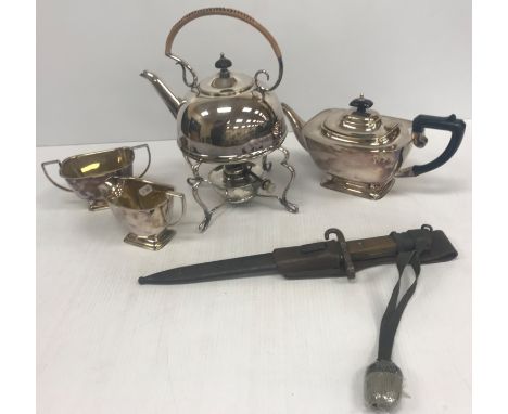
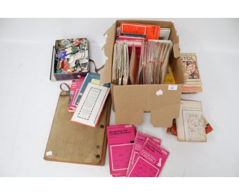
Lot 324
A silver plated three piece tea set with plastic handles and a plated spirit kettle in the Arts & Crafts manner No'd 34738 to base together with a Victorian walnut and brass inlaid sewing box 29.5 cm wide x 21 cm deep x 15 cm high and a Pilot tin deed box containing various ephemera, including war time notebook relating to Private H F Cook, various photographs, mainly post war, a World War II bayonet, various maps including "Bacon's Large Print Motor Map of South West England", "Ordnance Survey Contoured Road Map of Tunbridge Wells", "Fireguard's Handbook No. 14", "Protection of Your Home Against Air Raids Manual", etc.
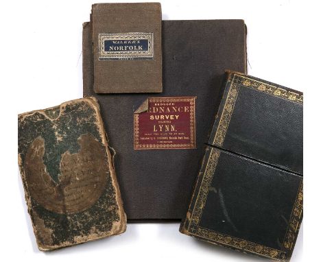
Lot 673
Hobson, William Colling. Cartographer, Walker. (J & C ) Engraver. 'Map of the County Palatine of Durham 1840', coloured and folding in thirty two sections, in an outer gilt tooled leather box plus 'Walkers Norfolk', a folding map 1843 plus two further folding maps 'Ordnance Survey around Lynn' and 'England, Wales and Part of Scotland. All in used condition (4)
Lot 573
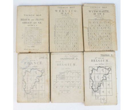
A collection of WW I linen backed maps, Trench map examples to include Belgium and France Sheet 28 S.E. Edition 5A, Wervicq 28 S.E. 1. Edition 5A, Wytschaete 28 S.W. 2. Edition 6A, Lens 11. Edition 2. France with Middlesex Regiment stamp, Belgium Edition 2. Tournai 5. and Hazebrouck 5A, each hand written A.N. Welles? and one other Ordnance Survey map for England and Wales Sheet 125. (7)
Lot 186
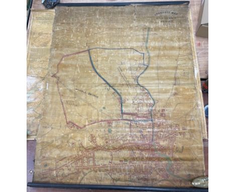
VINTAGE ORDNANCE SURVEY map of Edinburgh showing Turnhouse Airport sheet, NT 17 SEwith also OS map showing Berwickshire Lauder Burgh sheet NT 54 NW with also OS Selkirkshire sheet NT 22 SW - in good condition overall with no obvious tears etc -dimensions approx 22" x 27" approxApprox 4 pieces
Lot 182
ANTIQUE PAISLEY PARISH LARGE WALL MAP - ORDNANCE SURVEY MAP ' SEWING' THE PARISHES OF PAISLEY 1874 hessian backed wall map - the top wooden hanger is precariously attached and can be easily reattached/repaired - otherwise it is in good condition for its age - dimensions 42" wide x 50" height approx
Lot 189
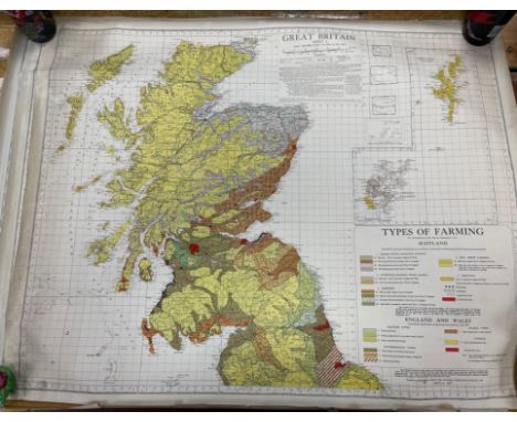
ORDNANCE SURVEY OF GREAT BRITAIN SOIL SURVEY OF SCOTLAND SYSTEMIC SOIL SURVEY Peebles Sheet 24 and part of Edinburgh sheet 32(SOIL) 46" x 28" approxand also a second survey mapSOIL SURVEY OF SCOTLAND - LAND USE CAPABILITY PEEBLES SHEET 24 and part of EDINBURGH sheet 32 (Land Of Capability) dimensions 27.5" wide x 41" height approxApprox 2 pieces

Lot 173
VINTAGE c1950's/60's COLOURFUL ORDNANCE SURVEY showing PEEBLES AND GALASHIELS and another showing EDINBURGH land utilisation survey maps - the Edinburgh map is on canvas style dimensions on larger Edin map 34"x 30" and the slightly smaller Peebles & Galashiels dimensions 26" wide x 33" width approxApprox 2 pieces
Lot 197
A mixed lot of ORDNANCE SURVEY MAPS to include map printers such as Ordnance Survey Office, Southhampton, Caledonian Books, National Grid and Bartholomew's (maps dissected and mounted on cloth), and covering areas such as Guildford, Falkirk, & Lanark, Lake District, England and Wales.Approx 24 pieces
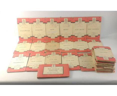
Lot 196
A fantastic lot for LOVERS of MAPS, HIKING and CYCLING! A substantial collection of 29 One-Inch Tourist Map ordnance survey maps to include Scottish areas such as Loch Tay, Ben Nevis/Glen Coe, St. Andrews and Kirkcaldy published by National Grid Seventh Series published in the 1950s and 60s.Approx 29 pieces
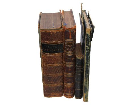
Lot 127
Timmins, Samuel. A History of Warwickshire, London: Elliot Stock, 1889, half-calf. Together with a foling hand-coloured Ordnance Survey map of The Environs of Birmingham, linen-backed, showing current 'railway lines, London: Printed at the Tower of London, 7 May 1831, with remnants of original leather wallet, and two others (4)
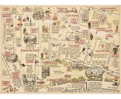
Lot 113
London & its Environs. A collection of 28 maps of London, late 19th & early 20th century, including Sayer (J. P.). Eleven (only) pictorial maps of London districts, originally published in 'Original Lithographic Prints Comprising the First Twelve up to October 1947, of the Series of Picture Maps of London...,' first published in the Strand Magazine, George Newnes Ltd. circa 1948, eleven colour lithographic pictorial maps of districts within London, each with an illustrated description to the verso, publisher's printed paper wrappers, two duplicates, each approximately 190 x 260 mm, together with Dower (John). The "Landmarks" of London, Cassell, Petter & Galpin, circa 1865, uncoloured lithographic map, 445 x 630 mm, with Riley (W. E.). Plan of London Showing Points at which Congestion of Traffic Occurs, Stanford's Geographical Establishment, 6th November 1903, large folding colour lithographic map, 650 x 970 mm, with another 13 regional and county maps similar, including examples by or after Appleton, Clarke, Dower, Ordnance Survey, Bartholomew and Davies, various sizes and conditionQTY: (28)
Lot 275
A selection of West Cornwall mining related paperwork and related items including Geevor Tin Mines plan of Prospect East and surrounding areas, two copy Geevor plans for Levant Incline and pumping chamber, a 1908 ordnance survey map of Pendeen, various other ordnance maps of West Cornwall, copy plan of Wheal Owles and a small selection of illustrations of Botallack and Levant Mines
![Cycling Maps: Bacon (G.W. & Co.) Bacon's Cycling Map[s] of Ireland also Showing Railways & Stations, 8 Parts, In](https://cdn.globalauctionplatform.com/2628653e-d104-4c72-aefa-afff00d29e0e/b3d3f7da-364a-40cd-ac6c-b003012a090b/468x382.jpg)
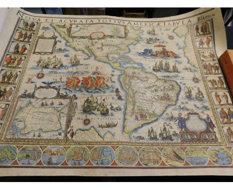
Lot 352
Cycling Maps: Bacon (G.W. & Co.) Bacon's Cycling Map[s] of Ireland also Showing Railways & Stations, 8 Parts, Index & 7 divisional fold. cold. linen backed maps, Edinburgh (J. Bartholomew) c. 1910, reproduced by Permission from The Ordnance Survey, in orig. full leather container. Fine Set. (1)
Lot 354
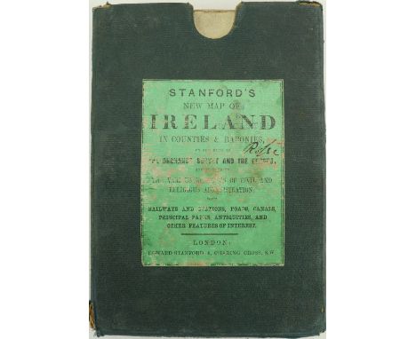
Map: Stanford (Ed.) New Map of Ireland in Counties and Baronies, on the basis of The Ordnance Survey & The Census... Lg. fold. hand coloured linen backed map, fold. 8vo, Lond. n.d. c. 1860, approx. 99.5cms x 79cms (39" x 31"), in orig. cloth slipcase. Both inscribed 'Rosse.' As a map, w.a.f. (1) Provenance: Birr Castle Estate.
Lot 742
A vintage lockable metal box along with small collection of vintage ephemera including a Geographia Footpaths map for Reigate area, an Ordnance Survey 1940 Second War Revision, Sheet 45, map of Buxton & Matlock published by the War Office in 1941, a 1943 illustrated souvenir of New York City, a souvenir booklet commemorating the crowning of King George VI and a part filled album of football skills cigarette cards.
![Ordnance Survey.- [Ordnance Survey of England and Wales, on the Scale of One Inch to a Mile], 111 map sheets numbered 1 to 11](https://cdn.globalauctionplatform.com/619f653b-98ff-4bdf-9ce7-aff900c462e6/49550b4e-059d-43ee-854e-aff900ca04a3/468x382.jpg)
Lot 207
Ordnance Survey.- [Ordnance Survey of England and Wales, on the Scale of One Inch to a Mile], 111 map sheets numbered 1 to 110 as per the "original" numbering system, with 68 [NE Norfolk] in 2 parts, engravings, many with original hand-coloured county divisions, each sheet approx. 660 x 980 mm (26 x 38 1/2 in), dissected and mounted on linen, bearing the mapseller's red star label of J. Gardner, sole agent, on verso, minor occasional spotting and surface dirt, folding with green morocco gilt numbered thumb tabs, tab to sheet 100 missing, map sheets 97-110 appear to be from a [?]later edition without hand-colouring, all folding without slipcases, 4to, Colonels Mudge, Colby and others, The Tower, circa 1805-90; together with 4 variant summary publications on the Maps, Plans, and Other Publications of the Ordnance Survey, original paper wrappers, 1875, 1890, 1897, and 1903
Lot 515
Three maps of Cornwall. William Westcott Rundell (Falmouth). 'Cornwall,' inset map of the Scilly Isles, laid on linen, a rare map of Cornwall, William Rundell does not appear in 'Worms and Baynton Williams British Map Engravers, published by W. Wood, Fore St, Devonport.'Map of the County of Cornwall Divided into Hundreds Containing the District Divisions and Other Local Arrangements,' cloth backed by Edward Stanford, Charing Cross, [circa 1880].Philips New Series of County Maps from the Ordnance Survey: 'Cornwall' by George Philip, circa 1900. (3)
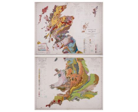
Lot 23
British Isles.- Geological Ordnance Survey.- Collection of 27 geological maps, from various editions, including two large sheets of the British Isles, sheet 1 of England and Wales, sheet 2 of Scotland, a large double-page 'Tectonic Map of Great Britain and Northern Ireland', and other regional geological maps, colour-printed maps, all mounted on linen, various sizes between 330 x 440 mm (13 x 17 1/4 in) and 840 x 1070 mm (33 x 42 1/8 in), old folds and handling creases, colours generally bright and vivid, all unframed, the majority circa 1950s (27)
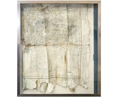
Lot 439
* Spitfire P9372. Part of an airman's navigational map recovered from Spitfire P9372 which was shot down on 9 September 1940, the map produced by the Ordnance Survey Office Southampton 1933, stamped with the dates 21 Aug 1937, 25 Jan 1938, 23 Feb 1938 and annotated by Pilot Official William Charles Watling in pencil on the right-hand side, presented in a glazed display case 61 x 43 cm QTY: (1)NOTE:Important Notice: All lots from the Tonbridge Battle of Britain Museum (lots 401-557) will remain in situ in the Museum and will only be available for viewing and collection from there in Tonbridge, Kent. All viewings and collections are strictly by timed appointment - please see front of catalogue or contact the auction office for details.Provenance: Tonbridge Battle of Britain Museum, Malcolm Pettit.See lots 450, 452, 494, 507 and 508.
Lot 188
Ordnance SurveyCity Plan of Leeds.Linen-backed folding map, Sheet CCXVIII.2.21, 1891 first edition, surveyed 1889, 64 sections, 137.5cm x 104 cm, original cloth covers with paper label;'Geographia', Plan of Leeds. linen-backed folding colour map, no date (c1935 in pencil), 114cm x 104cm, with index (taped) in original cloth gilt covers;Bain (James), The Authentic Map Directory of South Lancashire. 'Geographia', no date, quarto atlas, 208 pages plus index, original cloth gilt;Bacon (G.W.), New Commercial & Reference Chart of the British Isles,.Folding linen-backed colour map on two sheets, each approx 62cm x 97cm, 1 inch to 15 miles, original cloth gilt covers;Richardson's New Map of the British Isles.Folding linen-backed colour map on two sheets, each approx 61cm x 94cm, repairs to rear fold intersections, original cloth gilt covers. (5)
Lot 193
MapsPaterson (Capt Daniel), Paterson's British Itinerary, Being a New and Accurate Delineation and Description of the Direct and Principal Cross Roads of Great Britain. In two vols (Vol II only), 1785, engraved title, strip maps, worn contemporary calf;Ordnance Survey - Halifax and Huddersfield (Sheet 230/231).Large hand-coloured, linen-backed, folding OS map (six inch to the mile), surveyed 1848-9, published 1854, 60 sections, 128cm x 193cm;Ordnance Survey - Burley in Wharfedale.Large linen-backed folding OS map (1/2500, 25.344 inches to the mile), surveyed 1889, reprinted 1893, 32 sections, 135cm x 106cm, hand-coloured areas identifying ownership (with key in margin), linen fragile;Ordnance Survey - llkley and Otley.Large linen-backed folding OS map, Sheets CLXIX and CLXX (six inches to the mile), 1895, 32 sections, 129cm x 192cm, waterways coloured on second sheet; Jackson's Map of the Bramham Moor Hunt.Richard Jackson, no date, linen-backed folding map, 32 sections, 71cm x 95cm, original roan gilt covers (worn);Jeffreys (Thomas), The County of York, Survey'd in MDCCLXVII, VII, IX and MDCCLXX, 1775 (1973), large folio reproduction, foxing to edges and endpapers, original bindings;Whitaker (Harold), A Descriptive List of the Printed Maps of Yorkshire ....1577-1900, YAS, 1971, original cloth. (7)
Lot 294
Symons Alderman John: Kingstoniana. 1889 Hull. Folding map; other books and booklets of Hull interest; Victorian and later paper ephemera including newspapers, theatre programmes, letter headings and invoices, PDSA poster, sports programmes, social events, first day covers, Ordnance Survey maps, DVDs etcCondition Report:Condition varies dependent upon age but most in reasonable condition.Some rusting of staples to programmes etc
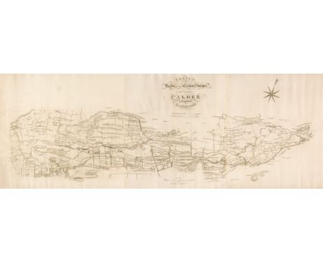
Lot 272
Scotland. A collection of fifteen maps, 18th & 19th century, engraved county, country, regional, city, and road maps, including Clerk (Thomas). Sketch of the Roads within the Eastern Division of the District of Calder in the County of Edinburgh [and] Sketch of the Roads of the Western Division of the District of Calder in the County of Edinburgh, circa 1820, two uncoloured engraved maps, the first on three conjoined sheets, 470 x 1300 mm, the second on three conjoined sheets, some dust soiling, 680 x 1300 mm, together with Arrowsmith (John). Map of Scotland constructed from original materials obtained under the Authority of the Parliamentary Commissioners..., 1807, large engraved map with contemporary outline colouring, sectionalised and laid on linen, some spotting, staining and dust soiling, 1815 x 1435 mm, with Wallis (J, publisher). A Commercial Map of Scotland with the Roads, Stages and Distances brought down to the present time by J. Knox, January 11th 1791, engraved map with contemporary wash colouring, sectionalised and laid on linen, inset map of the Shetland Islands, some dust soiling and staining, slight offsetting, near-contemporary ink ownership signature and address to verso,735 x 560 mm, contained in a contemporary marbled card slipcase with oval publisher's label to the upper cover, worn and rubbed, plus Wood (J. surveyor). Plan of the Town of Dunfermline from Actual Survey..., Edinburgh, 1823, engraved map with contemporary wash colouring, laid on linen, some spotting and overall toning, presented on contemporary turned and stained wooden batons, 540 x 580 mm, with another 10 maps by or after Morden, Moll, Harrison, Ordnance Survey, Cary, Thomson and Neele, various sizes and conditionQTY: (15)
Lot 59
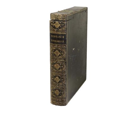
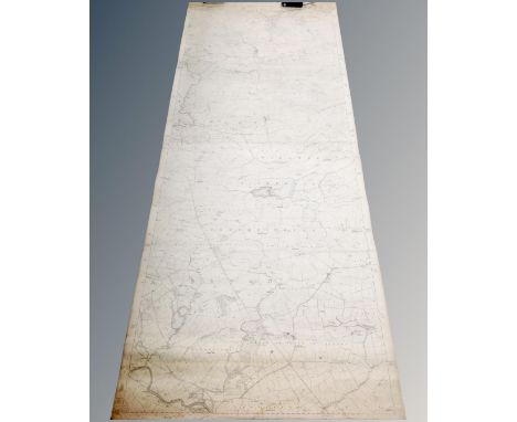
Ordnance Survey - North YorkshireA collection of original six inch OS maps, comprising Sheets 43 (Greenhow); 44 (Danby); 45 (Egton Bridge); 46 (Fylingdales); 47 (Robin Hoods Bay);48 (Howgill); 49 (West Baugh Fell); 50 (Abbotside); 51 (Swaledale - Askrigg Common); 52 (Grinton - West Bolton); 53 (Downholme - Hawxwell); 54 (Tunstall, Catterick); 55 (Kirby Fleetham); 56 (Northallerton); 57 (Snilesworth); 58 (Fangdale). Surveyed between 1848 and 1854.Southampton: Ordnance Map Office, individually published between 1852 and 1857, sixteen linen-backed maps, each approx 65.5cm x 96cm, scale of 6 inches to the mile (1:10,560). Ex library with usual evidence, centrally bound in library quarter morocco.Other than a little dust marking to margins in places, maps generally VG. No defects found. Usual library evidence to endpapers and binding. Binding rubbed abd bumped..
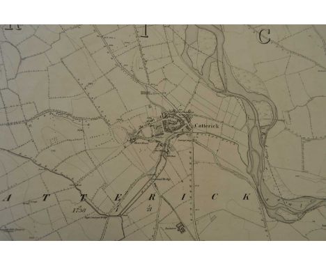
Lot 61
Ordnance Survey - North YorkshireA collection of twelve original six inch OS maps, comprising Sheets 51 (Swaledale - Askrigg Common); 52 (Grinton - West Bolton); 53 (Downholme - Hawxwell); 54 (Tunstall, Catterick); 66 (Bainbridge - Askrigg); 69 (Patrick Brompton); 82 (Bishopdale - Stalling Busk); 85 (Thornton Watlass - Masham); 98 (Buckden - Litton); 99 (Stonebeck); 100 (Masham Moor). Surveyed between 1847 and 1854.Southampton: Ordnance Map Office, individually published between 1852 and 1857, twelve linen-backed folding maps, each approx 65cm x 97cm and in eight sections, scale of 6 inches to the mile (1:10,560). Boundary line on sheets 100 & 101 lined in red, minimal red annotation to sheet 54, pencil annotation to sheet 53. Marbled paper covers to each map. Housed in black roan gilt folio book-form case with two part hinged spine and head-piece.Occasional light stain (see images). Wear to case.

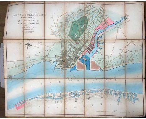
Lot 61
Folding maps. RENDEL (J M) Plan of Docks and Warehouses proposed to be made at Birkenhead, November 1844, hand coloured folding plan by J & C Walker, 62 x 75.5cm, cover detached and rubbed; BACON (G W) Map of England and Wales (North Sheet), circa 1920s, coloured, 64 x 101cm, wallet case; WHITE (W) Map of Suffolk, 1874, 44.5 x 57cm; Colchester district, 1838, cover marked 'Eastern Counties Railway', 64 x 50cm; three Guides to Portsmouth, 1825 (damp and brown stained), 1834, 1850 (toned); Ordnance Survey map of part of Devon between Bude Bay and Bideford Bay, hand coloured, 1813, 66 x 110cm; Ordnance Survey Index Map to England and Wales, 64 x 95cm (9)
![London. Lewis (Samuel). [Atlas to the Topographical Dictionary of England] circa 1844, lacking title and preliminaries, uncol](https://cdn.globalauctionplatform.com/b3fbe50d-aae6-4645-8127-afcd00d44353/544af73b-4e4a-43d0-a004-afcf00c99168/468x382.jpg)
Lot 110
London. Lewis (Samuel). [Atlas to the Topographical Dictionary of England] circa 1844, lacking title and preliminaries, uncoloured folding engraved map of England and Wales and London and 42 (only) engraved county maps, some folding, some spotting throughout, some maps detached, upper hinge broken, contemporary cloth, lacking spine, 4to, together with Tegg (T. T. & J. publishers). New Plan of London &c. with 360 references to the Principal Streets etc. circa 1832, engraved map with contemporary outline colouring, sectionalised and laid on linen, slight staining, short split along one old linen fold, 440 x 625 mm, contained in a contemporary marbled card slipcase with publisher's green & black label to the upper cover, some wear to the extremities of the slipcase, with Crutchley (G. F.). A New & Improved Map of the Environs of Windsor extending from 14 to 18 Miles round the Castle, J. B. Brown, Book & Print Seller to the Royal Family Windsor, circa 1830, engraved map with bright contemporary wash colouring, sectionalised and laid on linen, 300 x 240 mm, bound in contemporary green gilt cloth boards, plus another approximately 75 late 19th & 20th-century folding maps of London and its environs, with examples by or after Bacon, Ordnance Survey, Philips, Gall & Inglis, Smith & Son, W H Smith, "Geographia", Kelly, Bowen and Stanford, various sizes and conditionQTY: (approx. 80)NOTE:The second item described. Howgego number 295, state 8.
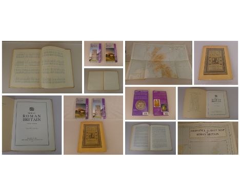
Lot 714
3 x Historical Maps comprising a large fold out Map of Roman Britain (Third Edition) published by The Ordnance Survey Chessington 1956, an Ordnance Survey Roman Britain Historical Map 5th Edition and an Ordnance Survey Roman Britain Historical Map, all three maps are in good, very good condition (see photographs. Good condition. All autographed items come with a Certificate of Authenticity. We combine postage on multiple winning lots and can ship worldwide. UK postage from £5.99, EU from £7.99, Rest of World from £9.99
-
1765 item(s)/page