We found 1765 price guide item(s) matching your search
There are 1765 lots that match your search criteria. Subscribe now to get instant access to the full price guide service.
Click here to subscribe- List
- Grid
-
1765 item(s)/page


Lot 382
*WWI RFC/RAF - Pilot`s Flying Log-Book and related mementos to Lieutenant Herbert Alfred Denny (Flt Cadet 2nd Lieut) c. 1918. Joining the School of Military Aeronautics he underwent preliminary 6-week induction course during November/December 1917, and then transferred to further training at Thetford Aerodrome, whence the log book shows first flying entry dated 3rd May 1918 and continues until March 1919, covering all aspects of flights made, transition from dual-instruction to first solo flight dated 21st May 1918, and subsequent instructional training including Photography, Forced Landings, Stall-turns, Bombing and Ground Attack etc on various machines including DH6, RE8 and DH9 aeroplanes. He was transferred to the Western Front on 21st August 1918 and further entries include Reconnaissance, Line-Patrol, Dawn Patrol, and Raids etc. to Menin, Lille, Ypres, Armentieres, Courtrai, Couines, Quesnoy, and many other locations in the region where fighting was heaviest especially in the final weeks before the armistice, culminating with a last combat flight on 9th November 1918 a Raid on Lessines. Thereafter continuing with few flights during the winter of 1918/19, concluding with a final entry on 7th March 1919 with a Mail Flight to Cologne. In addition to the log-book, this lot includes a group of original aerial photographs taken by 206 Squadron over the Western Front, variously captioned and with printed map-references, and some hand-captioned verso, together with three captured enlarged original German Aerial photographs, and also with the pilot`s personal aerial maps and Ordnance Survey maps of North West Europe, Hazebrouck, Belgium & France, his knee-pad map-holder with fold-out large-scale map of the region, showing bullet-hole damage to lower edge, when shot at during a Raid. Further accoutrements include Training-Transfer Cards for the RAF dated Mar-July 1918, an original `Squadron Orders` sheet dated October 28th 1918, and two bombing-practice lead-weighted coloured cloth streamers (-)


Lot 467A
"Malmesbury", a hand-coloured engraved map published at the Ordnance Survey Office Southampton, AFTER JOHN SELLER "Wiltshire", hand-coloured engraved map and a miscellaneous quantity of maps and engravings relating to the County of Wiltshire and town of Malmesbury, together with a Guinness 1981 calendar
Lot 996
B A F PIGOTT: FLOWERS AND FERNS OF CROMER AND ITS NEIGHBOURHOOD, [1885], 1st edn, orig decor cl gt + C M HOARE: SHORT HISTORY OF THE PARISH OF MUNDESLEY ….., 1914, 1st edn, orig card wraps + ORDNANCE SURVEY CONTOURED ROAD MAP OF CROMER, 1922, No 58, 1” map, Popular Edition, 21” x 30” + D MAXWELL: UNKNOWN NORFOLK, 1925, 1st edn, orig cl gt, d/w + A C SAVIN: HISTORY OF CROMER, 1950 reprint, orig card wraps + WHO’S WHO IN NORWICH, 1961, orig limp rexine (6)

Lot 332
Dr. Butler`s Atlas of Modern Geography and Atlas of Ancient Geography, two volumes, one dated 1826 five modern books on maps and four Ordnance Survey maps; Antique Maps by P.J. Radford, 1965 Map of Roman Britain, Ordnance Survey, 1956 Old Maps by P.J. Radford Maps and Map-makers by R.V. Tooley ,1962 Meiklejohn`s Intermediate School Atlas by John Bartholomew, 1953 Military Maps of Marseille - Nice 1944 East Anglia 1940 War map of Europe, Western South Wales 1940

Lot 98
Ordnance Survey. Report on the Ordnance Survey of the United Kingdom for 1855-56, 27 pp., twenty-nine plates including maps that depict the progress of six-inch to a mile map coverage in Ireland, England/Wales and Scotland, plus numerous specimen plates demonstrating the effectivness of electrotype and photographic reductions, bound with Report on the Ordnance Survey Commission; together with Minutes of Evidence, 1858, five engraved plates incl. four folding, bound with Report of the Progress of the Ordnance Survey and Topographical Depot, to the 31st December 1858, and similar reports for the years ending 1860-1872, all reports containing folding engraved maps showing the progress of work in Ireland, England/Wales and Scotland, all works bound into two volumes, contemp. cloth, one cover detached, folio (340 x 210 mm). Rare on the market. In 1855 the Ordnance Survey had just emerged from a state of transition having been newly placed under War Office administration and with a new Inspector-General of Fortifications in Lieutenant-Colonel Henry James. The introduction to the first report in this lot, which was the very first detailed report on the Ordnance Survey presented to Parliament, lists the recent achievements of the Ordnance Survey including the six-inch to a mile mapping of Ireland completed in 1846. The Irish maps Ôhaving proved to be of such great value to the public for such numerous purposes not originally contemplated` led to the continuation of the six-inch project to Scotland and Northern England which, together with the production of one-inch maps and 1/2500 (just over 25 inches to a mile) scale maps for urban areas, meant that the Ordnance Survey was fully stretched at this time. Much of the first report therefore proposes a number of recommendations to save time and labour including a new process for producing photographically reduced one-inch maps from six-inch maps, the production of electrotypes which were exact copies of the original copper plates produced to preserve the original, and developments in printed colour (hand colouring was done by boys of 13 and 14 years old for between sixpence and a shilling a day). There are specimens of many of these proposed production methods contained within the first report and the subsequent reports each contain maps depicting the growing level of coverage. (2)


Lot 43
Cheshire. Speed (John), The Countye Palatine of Chester with that most ancient Citie described, sold Bassett & Chiswell, [1676], hand coloured engraved map, inset town plan of Chester, strapwork cartouche and mileage scale, 41 x 52.5cm.; 16.25 x 20.75in, English text on verso, together with a framed Plan of the Manchester Ship Canal, drawn by "Geographia" Ltd, London and based upon the Ordnance Survey Maps, with scale, colour map, 28.5 x 124cm.; 11.25 x 49in (2).
Lot 62
Thirteen assorted Cases of Maps including WYLD James, The Crimea, folding, ARROWSMITH John, The Crimea chiefly from Surveys made by order of The Russian Government, large folding Map Seat of War in the Krimea, in slip case, The Oarsman and Angler`s Map of the River Thames, Edward Stanford, Admiralty Chart of the Baltic, folding Map of Bedford Level, four leather bound slip cases of Counties of England and Wales and three folding Ordnance Survey Maps in red slip cases
Lot 391
Royal Garrison Artillery, 73 Company, Notes on the Indian Frontiers, with pocket for maps at back, The War Office, Notes on Map Reading, 1929, Manual of Map Reading, Photo Reading and Field Sketching, 1929, and seven unassociated `Bartholomews` or Ordnance Survey Maps for Hereford and Devon and Cornwall (10)
Lot 451
19 various Ordnance maps comprising "Swindon", "Cricklade", "Northleach", "Moreton-in-the-Marsh", "Chipping Norton", "Ross", etc, contained within a leather bound folio, a Bacon`s "New survey map of Staffordshire and Shropshire", a Bacon`s "New Library Map of South Wales", a survey map depicting Richmond and Catterick, and one volume "Devonshire" with county map by ROBERT MORDEN (Ex Dartington Hall Library Devon Collection), leather spine and cloth boards

Lot 1634
ORDNANCE SURVEY: EASTON BAVENTS, REYDON AND SOUTHWOLD PARISHES SHEET XXIX 14, part col’d zincographed map 1884, approximately 25” x38” + ORDNANCE SURVEY: COOKLEY, HUNTINGFIELD, LINSTEAD MAGNA AND LINSTEAD PARVA PARISHES, part col’d zincographed map, 2 examples, approximately 37” x 26”, all laid down and in mixed condition (3)
Lot 253
MUDGE Col, Old Series Ordnance Survey Map, folding on linen, covering Berkshire, Middlesex, Hampshire, Surrey, Buckinghamshire, Hertfordshire and Oxfordshire, Roman Numeral VII in corner, no actual title, marked engraved at the Drawing Room in the Tower 1816 by Col. Mudge, Ben J Baker & Associates, etc, green cloth binding (1)

Lot 315
Ordnance Survey. Kent Surrey and Sussex 2 sheets III and VIII the former from Rye and the Isle of Sheppey to North Foreland the latter from Wokingham to Croydon and Selsey Bill to Brighton 2 electrotype map sheets each c.1265 x 975mm. both dissected and linen-backed both with certain rivers and roads neatly inked over the former with browning to three section edges the latter inscribed in the upper margin both folding into contemporary cloth slipcases each bearing the mapseller`s label of Charles Wyld on the front and a manuscript title label on the side 8vo 1864 and 1871 respectively (2).

Lot 325
Ordnance Survey.- Environs of London reduced ordnance map of London engraving with original hand-colouring 710 x 820mm. linen-backed surface dirt some tears along folds folding into green cloth boards worn 8vo W. H. Smith & Son`s c.1890; with another W. H. Smith & Son`s reduced ordnance map of Kent and sheet 7 of Major Colby`s Ordnance Survey (3)


Lot 172
Alison, A. History of Europe. 1860-61. 24 volumes including atlas and index volume, contemporary calf, rubbed; Bewick, Thomas History of British birds. Newcastle: E. Walker for T. Bewick, 1799-1804. 2 volumes, 8vo, woodcuts, contemporary calf, worn, one volume rebacked, one volume worn, covers detached; Archer, T. The war in Egypt and the Soudan. 1886. 4 volumes, 8vo, original cloth gilt; Groome, F.H. Ordnance gazetteer of Scotland. 1884. 6 volumes, 8vo, plates, folding maps, original cloth gilt; Churchill, Sir W. The second world war. 1948-1954. First editions, 6 volumes, 8vo, dust-jackets; Dulac, Edmund Fairy book. [N.d.], 4to, 15 mounted coloured plates, original cloth; Ordnance Survey Index to the Ordnance Survey of Peebleshire. Undated, hand-coloured engraved map, dissected and backed on linen, folding into cloth covers; Gibbon, Edward The history of the decline and fall of the Roman Empire. London, 1817. 12 volumes, 8vo, contemporary calf, rebacked, some spotting; Clarendon, E. Hyde, Earl of The history of the rebellion and civil wars in England. Oxford, 1707. 3 volumes bound in 6, 8vo, engraved portraits, rebacked, boards somewhat wormed; Potter, Beatrix The tale of little pig Robinson. 1930, reprinted. 4to, coloured plates, dust-jacket (quantity); sold not subject to return
Lot 722
JOHN TAYLOR: THE ILLUSTRATED GUIDE TO SHEFFIELD AND THE SURROUNDING DISTRICT ….., 1879, orig blind stpd cl gt, slightly worn, inner jnts split; + G W BACON: BACON’S COUNTY GUIDE AND MAP OF YORKSHIRE FROM THE ORDNANCE SURVEY, circa 1884, engrd col’d map, mounted on linen, orig blind stpd cl gt, ptd paper label to top bd, (2)

Lot 87
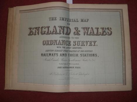
Bartholomew (John). The Imperial Map of England & Wales According to the Ordnance Survey, with the Latest Additions Shewing clearly every Feature of the Country, Railways and their Stations, Roads, Canals, Rivers, Gentlemen’s Seats &c. &c., pub. A. Fullerton & Co., [c.1866], seventeen lithographic maps inc. calligraphic title page, index bound in at rear, very lightly toned, new end papers, a.e.g., modern qtr. morocco gilt, large folio (1)
Lot 301
Folding maps. Buxey (George pub.), Buxey’s New Map of Southampton from the Ordnance and Special Surveys, n.d., c.1880, engraved map with orig. colour, folded and laid on linen, 780 x 745mm, orig. green cloth gilt boards, together with, Kelly (Thomas), Kelly’s Map of Newcastle upon Tyne and Gateshead, n.d., c.1880, engraved b & w map, sectionalised and laid on linen, 610 x 740mm, orig. cloth boards, worn and faded, with, Ordnance Survey (pubs.), Ordnance Survey of the Isle of Wight and Part of Hampshire, 1872, uncoloured electrotype map, railways highlighted in ink, sectionalised and laid on linen, 630 x 960mm, cloth end papers, housed in orig. red cloth slip case with pubs. printed label to upper board, slight wear to extrems., plus, Letts Son & Steer (pubs.), Ordnance survey map of southern Hampshire, 1810 [but later impression], engraved map with orig. outline colouring, sectionalised and laid on linen, 625 x 695mm, with three others similar (7)
Lot 358
Ordnance Survey. Hampshire, Isle of Wight, Surrey, Sussex and Kent, n.d., c.1830, six uncoloured engraved folding maps, sectionalised and laid on linen, each approx. 600 x 900mm, waxed paper chemise with miniature hand coloured index map laid on to outer cover, contained in contemp. diced calf gilt solander box, a little rubbed and bumped at extrems., together with two further loose Ordnance survey sheets of Hertfordshire and Huntingdonshire (3)
Lot 381
Wales. Cruchley (George Frederick), Cruchley’s Reduced Ordnance Map of England and Wales, Engraved on sixty-five sheets and planned on a Scale of two miles to an inch, sheets 16, 17, 22 - 24, 29, 30, 35, 36, 41 & 42 (only), eleven in total, n.d. c.1845, eleven engraved maps with original outline colouring, sectionalised and laid on linen, each approx. 530 x 670mm, marbled end papers with engraved outline map, in identical orig. blue cloth gilt, bumped at extrems. and a little faded, together with, Bacon (G.W & Co. Ltd. pubs.), Bacon’s New Survey Map of the Counties of Somerset, Dorset and Parts of Wiltshire..., n.d.. c.1900, colour printed map, sectionalised and laid on linen, 850 x 1130mm, marbled end papers, orig. cloth gilt, faded, spine frayed. The eleven maps by Cruchley comprise the whole of Wales. (12)

Lot 384
Wiltshire. A Map of the Parish of Purton in the County of Wilts., Finished in the Year of our Lord 1744, red & black ink on paper, laid on linen, ornate cartouche, mileage scale and table of explanation of the named houses, simple compass rose, some later pencil annotations, some dust soiling and staining, occ. closed tears and one small hole to image, mounted on later turned and stained wooden batons, 920 x 1670mm, an unusually large and detailed plan, together with, Ordnance Survey (pubs.), Map of South Gloucestershire and part of North Wiltshire, 1817 [but later]engraved map with orig. outline colouring, on six sheets conjoined, laid on linen, image size 1510 x 1350mm, mounted with contemp. turned stained baton at base, with circular brass ring and toggle to facilitate unrolling, the whole on a spring loaded brass roller attached to flat wooden baton for wall mounting. The Parish map of Purton shows the property of Neville Maskelyne, the astronomer royal, who is buried in Purton churchyard. (2)
Lot 389
Yorkshire. Bacon (G.W. & Co. Ltd.), Bacon’s Excelsior Map of Yorkshire and parts of Adjoining Counties, n.d. c. 1902, colour printed folding map, sectionalised and laid on linen, inset geological map of Yorkshire, elaborate strapwork cartouche, marbled end papers, 900 x 1130mm, contemp. blind stamped morocco gilt boards, rubbed at extrems., together with, Gaskarth (Henry pubs.), Plan of the City of Bradford as extended and adjoining Districts, n.d., c.1900, colour printed folding litho. map, sectionalised and laid on linen, 740 x 860mm, marbled end papers, ink ownership to front paste down, contemp. morocco gilt, bumped at extrems., with, Smith (W.H. pubs.), Environs of Leeds, Reduced Ordnance Survey, n.d., c.1920, colour printed folding map, laid on linen, 360 x 470mm, contemp. cloth with printers label to upper board, stained, with one other similar (4)


Lot 212
Stanford (Edward) Environs of London (Geological), 1895, hand-coloured, linen-backed folding map, original slipcase; Ordnance Survey, Geological map of Wigan, 1860, hand-coloured, linen-backed folding map, cloth; Geikie (Archibald), Map Showing the Surface Geology of Ireland .., nd, colour linen-backed folding map, school library stamps, original cloth; with a quantity of others (qty)

-
1765 item(s)/page