We found 36558 price guide item(s) matching your search
There are 36558 lots that match your search criteria. Subscribe now to get instant access to the full price guide service.
Click here to subscribe- List
- Grid
-
36558 item(s)/page
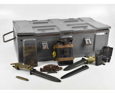

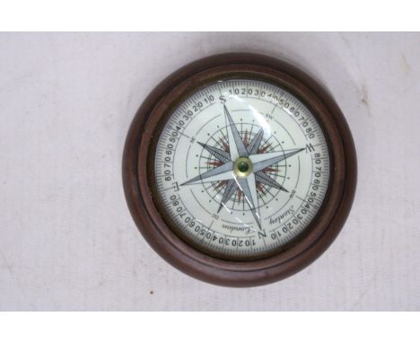
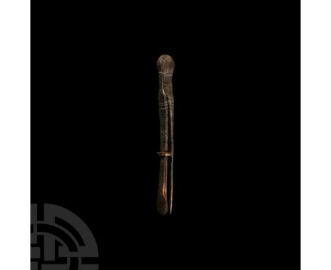
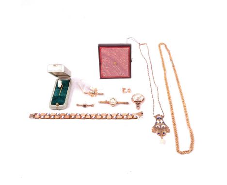
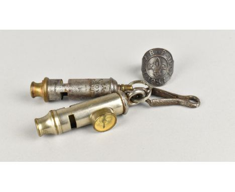
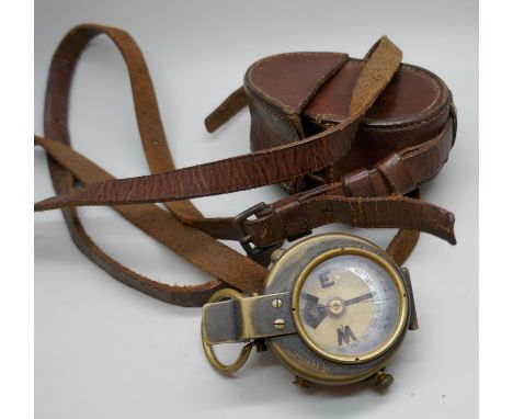
Lot 56
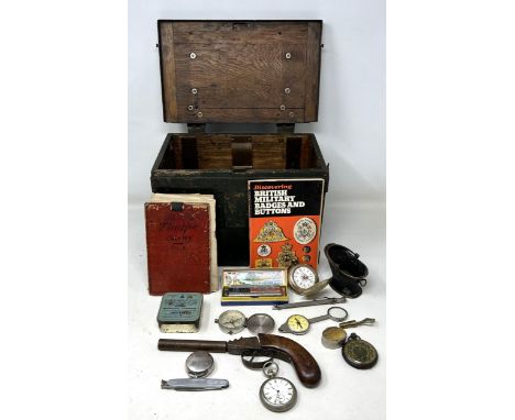
A collection of WWI, WWII and other military and collectors' items, to include a No 4 MK II bayonet and scabbard, a silver vesta case engraved ‘S.M.L.L. Worthington from W.A.A.C, 24th O.C.B, 19th March 1918’, a Royal Rifle Corps badge, a Boy Scout combination whistle/compass, a 1940 military whistle, flags etc (qty).
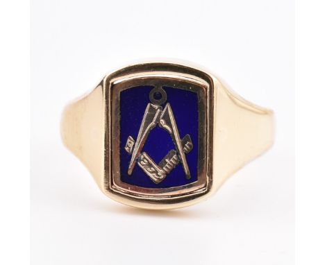
Lot 104
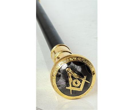
A hallmarked 9ct gold Masonic flip ring. The yellow gold signet ring having a reversible square head with Masonic square and compass motif set with blue enamel to polished verso and tapered shank. Hallmarked for Birmingham, date letter rubbed. Sponsor's mark WJP. Head measures 1.1cm x 1.4cm. Size N.5. Weighs 6.6g. All weights, measurements and sizes are approximate.
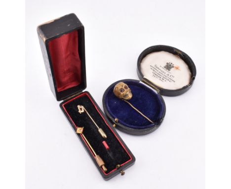
Lot 194
Two 9ct gold tie pins and a metal skull tie pin. The lot to include a 9ct gold Masonic tie pin with square and compass motif pierced head to polished pin, marked 9ct to verso. A 9ct yellow gold tie pin set with a single star set pearl, marked 9ct to verso. The lot to also include a metal tie pin with three-dimensional skull head set with red stone cabochon eyes, unmarked. Tie pins measure largest 5cm x 1.5cm. Smallest 4.5cm x 0.8cm. Total weight 5.9g. All weights, measurements and sizes are approximate.
Lot 696
Machado, José Sousa (Angolan, 1956-present); b. Luanda, moved to Portugal by 1961 PORTUGAL/SOUTH AFRICA, 500º Aniversário da Descoberta do Cabo da Boa Esperança [500th Anniversary of the Discovery of Cape of Good Hope], 1988, a plated bronze free-standing medal by J.S. Machado for the Casa da Moeda, bust of Bartolomeu Dias half-left, wearing hat, rev. map of western Europe and the west coast of Africa, Portuguese flags and markers on coast-line, two sailing ships below, radiant compass at upper left, edge impressed 589, 84mm, 340.50g (Laidlaw 1217). Virtually as struck £25-£35 --- Edition of 2,500. Bartolomeu Dias (†May 1500) led an expedition in 1488 in an attempt to discover a sea route to India. He was the first European known to have rounded the Cape of Good Hope, which he named the Cape of Storms
![Richer, Paul-Marie-Louis-Pierre (French, 1849-1933); b. Chartres FRANCE, Hommage à Jules Marey [Tribute to Jules Marey], 19](https://cdn.globalauctionplatform.com/a2b4effe-b481-4e18-ac55-b26f00c415a5/24752138-30ec-467d-b6b0-b26f00c50e12/468x382.jpg)
Lot 782
Richer, Paul-Marie-Louis-Pierre (French, 1849-1933); b. Chartres FRANCE, Hommage à Jules Marey [Tribute to Jules Marey], 1902, a bronze plaque by P.-M.-L.-P. Richer, bust left, farm building at left, rev. Marey, holding a compass, seated at a table on which are various physiological instruments, animated evocation of running men and galloping horses, edge impressed bronze and cornucopia, 64 x 50mm, 78.23g (Gaz. Num. 1905, p.16 and pl. II; Storer 2364; Brettauer 746; BDM V, 113; cf. Kölner Münzkabinett 112, 1024; cf. Baldwin 69, 157; cf. DW 24, 88). About extremely fine, patinated £60-£80 --- Prof. Dr Étienne-Jules Marey (1830-1904), scientist and chromo-photographer. His work was significant in the development of cardiology and physical instrumentation
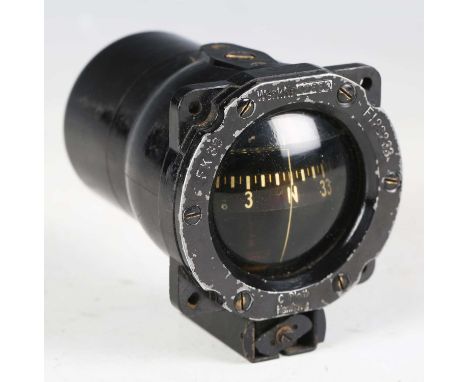
Lot 3587
A Second World War period German Luftwaffe aircraft magnetic compass by C. Plath, Hamburg, detailed 'FK38, Werk Nr 22530, Fl 23233'. Provenance: from the estate of the late David Sadler and originally owned by his cousin Anthony ‘Tony’ Gaze, DFC and two bars, Australian fighter pilot and racing driver. Note: Tony Gaze joined the RAF in 1940 and was based at Westhampnett, West Sussex. He flew 488 combat missions and is credited with 12.5 aerial victories, including a V-1 rocket and a Messerschmitt Me 262 jet. After the war, Tony was instrumental in the establishment of motor racing at Goodwood, after putting forward the idea to Frederick Charles Gordon-Lennox, 9th Duke of Richmond, also known as Freddie March. Tony suggested that the roads around RAF Westhampnett would be a great place for racing. Freddie March went on to found the Goodwood Motor Circuit at his Sussex estate. David Sadler clearly idolized his older cousin, which lead to his later interest in both Second World War aviation and motor racing, and items belonging to Tony were passed to him. Original 1930s-1940s footage showing the Sadler family, based in Chichester, can be found on Screen Archive South East.
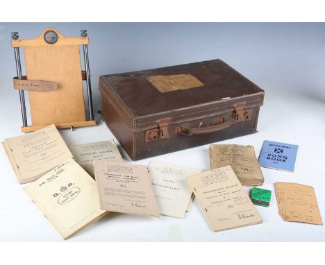
Lot 3604
A collection of military books and equipment belonging to 2nd Lieutenant G. Campbell, Royal Artillery, including various training manuals, drill books, advisory notes and a First World War issue military map holder compass board by Houghtons Ltd, London, 1913, all contained within an old suitcase.
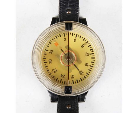
Lot 3583
A Second World War period German Luftwaffe pilot's navigation wrist compass, detailed to the back 'AK 39, Fl 23235-1', case diameter 6cm. Provenance: from the estate of the late David Sadler and originally owned by his cousin Anthony ‘Tony’ Gaze, DFC and two bars, Australian fighter pilot and racing driver. Note: Tony Gaze joined the RAF in 1940 and was based at Westhampnett, West Sussex. He flew 488 combat missions and is credited with 12.5 aerial victories, including a V-1 rocket and a Messerschmitt Me 262 jet. After the war, Tony was instrumental in the establishment of motor racing at Goodwood, after putting forward the idea to Frederick Charles Gordon-Lennox, 9th Duke of Richmond, also known as Freddie March. Tony suggested that the roads around RAF Westhampnett would be a great place for racing. Freddie March went on to found the Goodwood Motor Circuit at his Sussex estate. David Sadler clearly idolized his older cousin, which lead to his later interest in both Second World War aviation and motor racing, and items belonging to Tony were passed to him. Original 1930s-1940s footage showing the Sadler family, based in Chichester, can be found on Screen Archive South East.
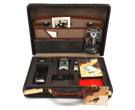
Lot 165
James Bond 007 - Tomorrow Never Dies (1997) An official limited edition promotional product placement licensees Brief Case. Produced in conjunction with the release of the film by Eon, the Brief Case features various exclusive products from the noted brand product placement companies featured in the movie. Includes: a miniature bottle of Smirnoff vodka with drinking glass, a die-cast model of Bond's series 7 BMW car, an Ericsson CF788 calculator in the form of a phone (with instructions), a Heineken barrel shaped can of beer, an Avis keyring in presentation box, a Wilkinson Sword razor, a Visa credit card companion with concealed bottle/can opener, tweezers, toothpick, compass and magnifying glass, two bottles of L'oreal nail polish and related postcard, 35 x 45 cm.Suitably the combination to the Brief Case lock is 007. The contents are presented within a bespoke cut foam inner liner, the Case retaining the original card hang tags.Condition Report: CR:- Full contents, some light marks to outside of case, contents and internally good condition.
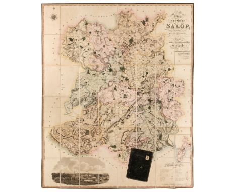
Lot 222
Shropshire. Greenwood (C. & J.), Map of the County of Salop from an actual survey made in the years 1826 & 1827..., published July 2nd, 1827, large-scale engraved map with contemporary wash colouring, sectionalised and laid on linen, table of explanation, calligraphic title, compass rose and a large vignette of the south-west view of Shrewsbury, slight offsetting, the map edged in green silk, marbled endpapers 1495 x 1225 mm, contained in a near-contemporary green morocco slipcase, the case worn and frayed with old lot number label to the upper sidingQTY: (1)
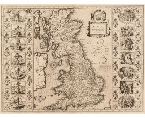
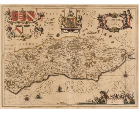
Lot 169
British Isles. Speed (John), Britain as it was devided in the tyme of the English Saxons especially during their Heptarchy, 1st edition, John Sudbury & George Humble [1611], uncoloured engraved map, large strapwork cartouche, compass rose and numerous rhumb lines, the vertical borders decorated with historical scenes, large margins, central fold professionally strengthened and repaired on verso, 385 x 510 mm, English text on versoQTY: (1)NOTE:R. W. Shirley. Early Printed Maps of the British Isles, 1477 - 1650, number 317.
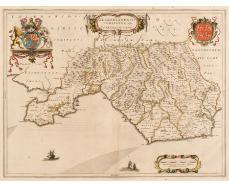
Lot 181
Glamorganshire. Blaeu (Johannes), Glamorganensis Comitatus vulgo Glamorgan Shire, Amsterdam: circa 1648, engraved map with contemporary outline colouring, large margins, slight text show through, 390 x 510 mm, Latin text on verso, mounted, together with Greenwood (C. & J.). Map of the South East Circuit of the Principality of Wales Comprising the Counties of Glamorgan, Brecon & Radnor from an actual Survey..., London: Greenwood & Co. January 26th 1831, engraved map with contemporary wash colouring, calligraphic title, table of explanation and list of hundreds, compass rose and uncoloured vignette of Llandaff Cathedral, 630 x 705 mm, mountedQTY: (2)
Lot 36
Greenwood (C. & J.). Atlas of the Counties of England from Actual Surveys made from the Years 1817 to 1833..., published 1834, double-page calligraphic title with a hand-coloured map of England & Wales, forty-six (complete) engraved maps with contemporary hand colouring, each with an ecclesiastical vignette, table of explanation, compass rose and calligraphic title, some maps with slight offsetting, title page creased with some dust soiling, Northumberland with a small closed repaired tear to the upper margin, damp stained throughout with twenty maps showing moderate water staining, later endpapers, modern half morocco with contrasting morocco gilt label to the upper cover, oblong folioQTY: (1)NOTE:Chubb CCCCLVIII (b).
Lot 175
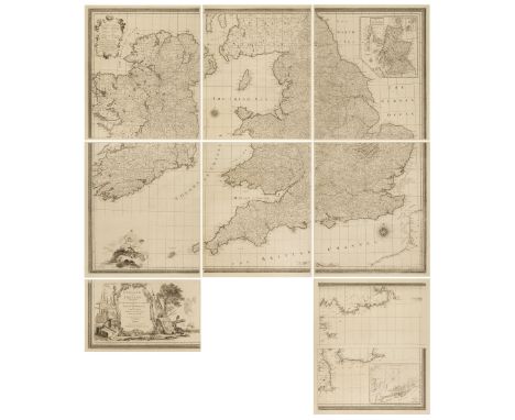
England and Ireland. Seale (Richard William), England and Ireland, containing all the Cities, Boroughs, Market Towns & Principal Villages; with the Coast of France from Calais to Brest..., London: printed for John Bowles, Robert Sayer, Thos. Jefferys and Carington Bowles, circa 1770, a very large uncoloured reticulated engraved wall map of nine maps on eight sheets, inset map of Scotland, an elaborate martial cartouche, two compass roses, a table of explanation and an allegorical classical vignette, margins uncut, seven sheets each approximately 630 x 540 mm, one sheet 325 x 540 mm, contained in a modern purpose map cloth portfolio with a morocco gilt title label to the upper siding, size of portfolio 650 x 415 mmQTY: (1)NOTE:The map was originally published by Thomas Jefferys in about 1750 and then re-issued, later in the 18th century. The map was separately published with the intention that it could be trimmed and joined together, either into a six-sheet map focusing on England and Ireland or with the addition of the three half-size maps added to the lower margin to include the cartouche and part of the north French coast. In very fine condition with no perceived damage or faults. Rare, with only one institutional copy found (British Library).
Lot 217
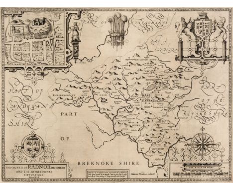
* Radnorshire. Speed (John), The County of Radnor Described and the Shyretownes Sittuatione, 1st edition, John Sudbury & George Humble [1611], uncoloured engraved map, large strapwork cartouche, mileage scale and compass rose, inset town plan of Radnor, 385 x 515 mm, mounted, framed and glazed, together with Blaeu (Johannes). Radnoria Comitatus Radnor Shire. Amsterdam: circa 1650, uncoloured engraved map, decorative cartouche and mileage scale, 385 x 500 mm, Latin text on verso, mounted, framed and glazed, with Saxton (Christopher & Kip W.). Radnor comitatus quem Silvares olim Incoluernt, [1610], hand-coloured engraved map, strapwork cartouche and mileage scale, 270 x 320 mm, mounted, framed and glazed, plus Jansson (Jan). Radoriensis Comitatus vulgo The Countie of Radnor, Amsterdam: circa 1648, engraved map with contemporary outline colouring, large margins, decorative cartouche and mileage scale, 380 x 485 mm, mountedQTY: (4)
Lot 224
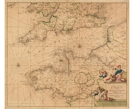
South of England. Four Sea Charts, late 17th & early 18th-century, four engraved sea charts including Danckerts (Theodore). Novissima et Accuratissima Canalis inter Angliae et Galliae Tabula..., Amsterdam: circa 1700, an engraved chart with contemporary outline colouring, trimmed to the neatline with the margins extended and strengthened on the verso, some spotting, 505 x 585 mm, together with Van Keulen (Gerald). A New Gradually Encreasing Compass Map, of a Part of the Sea Coast of England, in which is Contained the Coast of Sussex, Extending from Eastward of Hastings to Arundel Haven with their Shallownesses and Depths, 1698, uncoloured engraved sea chart, title repeated in Dutch, compass rose and numerous rhumb lines, some dust soiling and slight staining, 520 x 590 mm, with Van Keulen (Johannes). Nieuwe Kaart van Duyns en van Margat..., Amsterdam: circa 1698, uncoloured engraved sea chart, some staining and spotting, 560 x 520 mm, plus De Fer (Nicolas). L'Isle de Wight Dressée sure les Derniers Memoires..., Paris: circa 1700, hand-coloured engraved map, inset maps of Torbay and the Isles of Scilly, descriptive text in French below the image, old fold, upper left margin paired, 355 x 320 mmQTY: (4)
Lot 761
Circa late 2nd-4th century A.D. Featuring a compass and tweezers, free-moving collar to one arm, one arm with two oval terminals and one tapering to a point. Cf. Beutler, F. et al., Der Adler Roms. Carnuntum und der Armee der Cäsaren, Bad-Deutsch Altenberg, 2017, item 639, for type. 19 grams, 90 mm (3 1/2 in.). Acquired before 2000. From the collection of a European gentleman living in the UK.This instrument, a type of circinus formed of two flat-section arms, was widely used by masons and carpenters, as well as for making wall decorations for the preparation of repetitive elements such as spirals or circles. It was widely used by the agrimensores of the army, as is proven by a very similar specimen found in Carnuntum, the camp of the Legio XIIII Gemina.
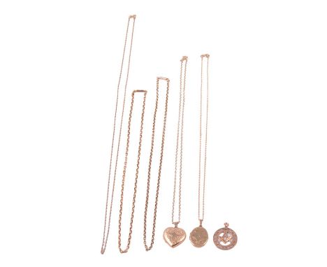
Lot 347
Five gold / yellow metal chains, two gold lockets, and a gold pendant, a 9 carat yellow gold rope link chain, bolt fastener, 67cm; a yellow metal belcher link chain, pad stamped 9c, tongue snap fastener, 45.5cm; another similar, 42.5cm; a 9 carat yellow gold oval shape locket with ruby to centre, on a 9 carat yellow gold rectangular link chain, bolt fastener, 45cm; a 9 carat yellow gold heart shape locket on a 9 carat yellow gold belcher link chain, bolt fastener, 45cm; and a 9 carat rose gold Masonic compass and square pendant; total gross weight 23.7g.Qty: 8
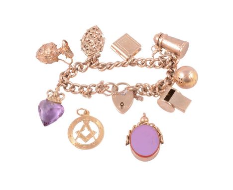
Lot 236
A 9 carat yellow gold charm bracelet with charms attached, a loose charm, and a fob, a 7.2mm wide curb link 9 carat yellow gold bracelet, fitted with a padlock fastener, hallmarked Birmingham 1960, and safety chain, with seven 9 carat gold and yellow metal charms attached, to include whistle, football, lidded tankard, Holy Bible, Moses in a basket, paste set ewer and amethyst heart surmounted by a crown; a loose 18 carat yellow gold Masonic compass and square charm, 3.4g; and a swivel fob set with oval cornelion and 9 carat rose gold mount; total weight 57g.Qty: 3
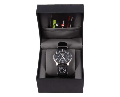
Lot 1044
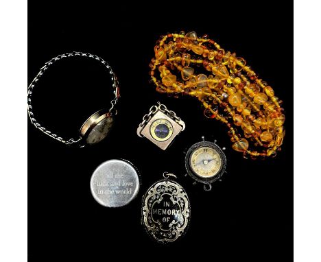
Traser - a gentleman's H3 Navigator wristwatch, 23mm circular black dial with arabic numeral chapter ring, centre seconds hand and date aperture, in a 43mm stainless steel case with carbon fibre bezel, fabric strap with compass attached, with box, outer card box and paperwork, quartz movement not working, may just need a battery, watch has not been worn.
Lot 1219
Victorian and later gold and gold-plated jewellery, a yellow metal compass fob; an Art Nouveau brass coloured enamelled sautoir with simulated freshwater pearl drop; a two row rose metal and enamel bracelet, 18cm; two pairs of stud earrings; a framed daguerrottype of a young lady with ringlets, possible connection to a merchant called Whitlock of Mercers Row, Northampton; a yellow metal guard chain (not gold); a seed pearl 35mm bar brooch; two other bar brooches; a pair of crystal cufflinks; and a carved coral stick pin in fitted case, a pair of crystal cufflinks.
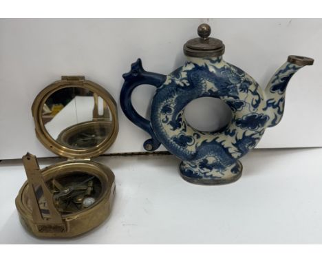
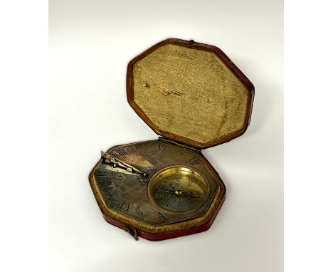
Lot 5186
CHAPOTOT, PARIS: A late 17th / early 18th Century Butterfield style silver pocket sundial by Chapotot, Paris thought to be circa 1680-1730. Octagonal form with engraved Roman chapter ring and hinged enamelled gnomon, with compass, 64mm x 57mm, housed within its original leather case (slight loss)This type of portable sundial was a fashionable traveller's accessory during the late 17th century. The latitudes of towns in Europe including Paris, Rome, London, Madrid and Dublin are engraved on the back. The hinged gnomon (triangular flap made to create a shadow) could be adjusted according to latitude. The gnomon folds flat and the sundial has cut corners to enable the dial to be enclosed in a case and carried in a pocket.The adjustable gnomon enabled the time to be read accurately in a variety of locations. Travellers still carried sundials even when watches became popular. Early watches were not always accurate for long and a dial enable them to be set regularly. A German travellers' guide of the time also recommended sundials over clocks while on the road because the chiming of clocks might attract thieves.This type of sundial is known as a Butterfield style dial as it was originally designed by Michael Butterfield, an English instrument maker who worked in Paris during the late 17th Century.
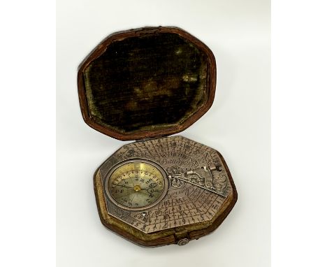
Lot 5187
MICHAEL BUTTERFIELD OF PARIS: A circa 1680-1700 silver pocket sundial, octagonal form with multiple Arabic and Roman chapter rings and hinged gnomon, with compass, 65mm x 57mm, housed within its original leather case. This type of portable sundial was a fashionable traveller's accessory during the late 17th century. The latitudes of towns in Europe including Paris, Rome, London, Madrid and Dublin are engraved on the back. The hinged gnomon (triangular flap made to create a shadow) could be adjusted according to latitude. The gnomon folds flat and the sundial has cut corners to enable the dial to be enclosed in a case and carried in a pocket. The adjustable gnomon enabled the time to be read accurately in a variety of locations. Travellers still carried sundials even when watches became popular. Early watches were not always accurate for long and a dial enable them to be set regularly. A German travellers' guide of the time also recommended sundials over clocks while on the road because the chiming of clocks might attract thieves. This type of sundial is known as a Butterfield dial as it was originally designed by Michael Butterfield, an English instrument maker who worked in Paris during the late 17th century.
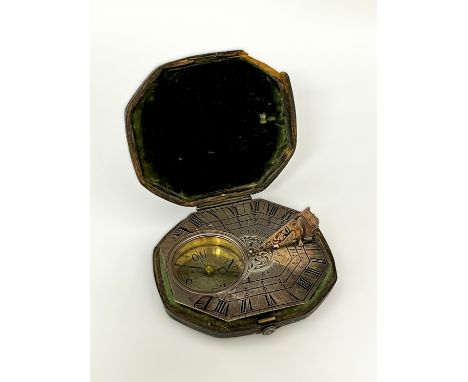
Lot 5185
A late 17th / early 18th Century Butterfield style silver pocket sundial, octagonal form with engraved Roman chapter ring and hinged gnomon, with compass, 76mm x 60mm, housed within its original leather case. The reverse is engraved with locations such as Gore (New Zealand), Tinian (Northern Mariana Islands), Guadeloup (French Caribbean), Manille (Manila - Philippines) and Siam (Thailand), suggesting that it may have had a connection to maritime navigation or exploration, given that many explorers, traders, or military figures travelled to these regions during that time. It was likely made for a person involved in maritime navigation or colonial trade, and the locations could mark significant ports or destinations encountered during travels.This type of portable sundial was a fashionable traveller's accessory during the late 17th Century. The hinged gnomon (triangular flap made to create a shadow) could be adjusted according to latitude. The gnomon folds flat and the sundial has cut corners to enable the dial to be enclosed in a case and carried in a pocket.The adjustable gnomon enabled the time to be read accurately in a variety of locations. Travellers still carried sundials even when watches became popular. Early watches were not always accurate for long and a dial enable them to be set regularly. A German travellers' guide of the time also recommended sundials over clocks while on the road because the chiming of clocks might attract thieves.This type of sundial is known as a Butterfield style dial as it was originally designed by Michael Butterfield, an English instrument maker who worked in Paris during the late 17th Century.
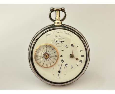
Lot 5150
BENJAMIN WEBB OF LONDON: A 19th Century silver pair cased combined pocket watch and compass by Benjamin Webb, enamelled face with three subsidiary dials, Roman numeral hour markers and gold spade hands to three, subsidiary seconds to six, compass to nine (faint hairline crack). chain fusee movement with verge escapement, finely pierced balance cock with diamond endstone, backplate signed Benjn. Webb London no. 200, By the King's Patent, 6.2cm diameterCONDITION REPORT: Movement clean but green stains on fusee barrel. Solder repairs to main case hinge. Movement running. Very faint hairline on dial from 8 to centre.
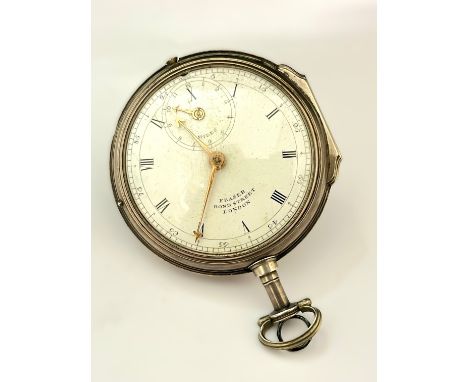
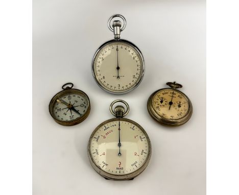
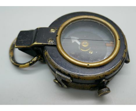
Lot 769
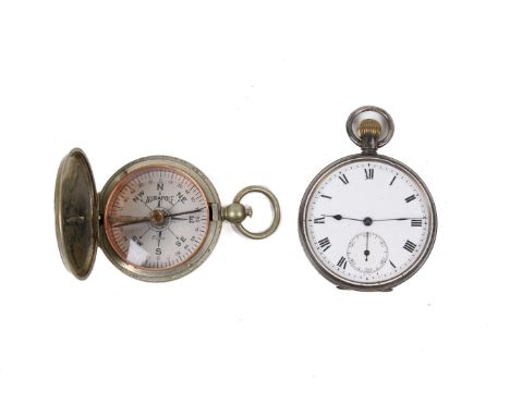
A silver pocket watch and a WWI period compass. The pocket watch with black Roman numerals to a white face, unmarked, with blued hands and secondary dial, hallmarks to inside of back cover; a Short & Mason Aurapole Tycos compass. (2). Condition Report: Watch funtions for a few seconds then stops.
Lot 500
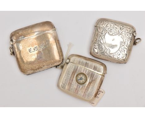
THREE SILVER VESTA CASES, each of a rounded square form, one with a scrolling foliate pattern and vacant cartouche, hallmarked 'Joseph Gloster' Birmingham 1906, an engine turned pattern case with compass hallmarked Birmingham, the third of a polished design with engraved initials, hallmarked 'Charles S Green & Co Ltd' Birmingham 1919, approximate gross weight 112.9 grams (condition report: general wear, all would benefit from a gentle clean and polish, wear and rust to the striker of the polished vesta)
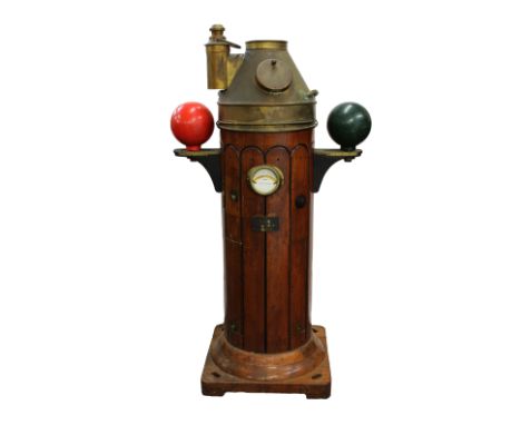
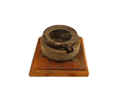
Lot 56
A teak and brass compass binnacle 'Sestrel' Dead Beat by Henry Browne & Co of Essex, the brass cover enclosing the Sestrel 2088N Dead Beat compass, flanked by twin spheres (Kelvin's Balls), with a mounted 'Sestrel' spirit level on the side above a plaque 'Sestrel, Henry Browne & Co, Station Works, Barking, Essex, Type 89521', teak with ebonised fluting, 81.2 x 53.3 x 146cm.
Lot 36
Royal Navy Interest - to include a gilt metal cigarette case H.M.S HOOD 1859, the hinged cover with applied emblem of bird & anchor with banner below, together with a brass cigarette case GIBRALTAR SOUVENIR, engraved with seaside town with boats in the foreground; lighter with applied Royal Navy anchor and crown, and a Sir Lord Kelvin 1824-1907 replica compass (4)
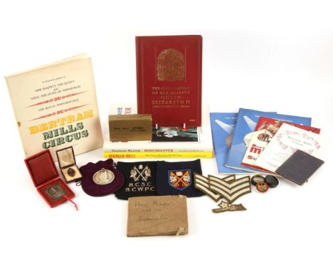
Lot 8292
Circus Interest. Collection of Bertram Mills Circus Show Master Captain Russell Pickering MBE. Including: Victorian medallion inscribed 'PRESENTED TO FUNNY FRANCIS FOR HIS MARVELIOUS PERFORMANCE ON THE STILTS by a few friends at the Alhambra Palace BELFAST OCT 1875'. The other depicting a clown. Approx. 6cm. Twin train mantel clock with plaque reading 'CAPT J. RUSSELL PICKERING M.B.E. A SOUVENIR OF THE MOTOR BALL AND CARNIVAL 19TH OCTOBER 1927. ROYAL OPERA HOUSE. COVENT GARDEN. FROM THE COMMITTEE'. 21cm high. A vintage pair of Rand No.1 Opera Binoculars in original box and packaging. Official Souvenir Programme for the Coronation of Her Majesty Queen Elizabeth II. 'How Mildew Won The Sploshville Cup', horse racing related family album, with story and photographs. Dancing medallion award 'Federation International De Danse Juan Les Pins. 1930, in fitted box. Military badges, patches Mess Rules book and pocket compass belonging to Russell Pickering (9 items). Bertram Mills Circus Supershow Olympia Season 1964-5 programme and table plan / list of guests. The Royal Performance Bertram Mills Circus Programme Olympia London 1959 and 1963 (x2). Bertram Mills Royal Performance Programme Olympia 1960. Norman Barrett signed limited edition book 'Ringmaster', Aardvark Publishing, 1994. 'Bertrum Mills - The Circus The Travelled By Train' by David Jamieson', Aardvark Publishing, 1998 (total items 22). Provenance: sold by Bertram Mills Circus Show Master Captain Russell Pickering MBE family descent.
-
36558 item(s)/page