

Collins, Capt. Greenvile 1693 Holy-Head Is Most Humbly Dedicated and Presented to Capt. William Wright "This very handsome chart shows Holy Island (historically known as Holyhead Island) and the western coast of the Isle of Anglesey. Only a few place names appear on the coast, including the town of Holyhead and “Penthrine” (Penrhyn). The chart shows good navigational detail, with soundings, anchorages, shoals, and rocks. A decorative compass rose orients the chart with north to the left, and four ships sail the surrounding waters. At bottom right is an inset with a coastal view of the islands of Anglesey and Holy. The decorative title cartouche features two female figures, one holding a cross and a chalice, and the other holding a serpent. The map is dedicated to Captain William Wright. In 1681 Capt. Greenville Collins (fl.1669-1694) an officer in the Royal Navy was appointed by the Admiralty to make a complete survey of the coasts of Great Britain. Prior to this date the charts used by English mariners were copies of Dutch charts that had many inaccuracies. The task of surveying the entire coasts was formidable and took about 7 years, at the end of which only 46 surveys were finally used in an atlas titled “Great Britain`s Coasting-Pilot Being a New and Exact Survey of the Sea-Coast of England,” which was first published in 1693." 22.1" W x 17.4" H A nice impression with attractive color printed on heavy paper.
We found 33014 price guide item(s) matching your search
There are 33014 lots that match your search criteria. Subscribe now to get instant access to the full price guide service.
Click here to subscribe- List
- Grid
-
33014 item(s)/page

Keulen, Johannes van 1681 Nieuwe Pas-Kaert vande Oost Kust van Yrland, Beginnende van de Hoeck van Waterfoort tot aen de Mayds, als mede de West Kust van Engeland van S. David tot Moul van Galoway… Large sea chart covering St. George`s Channel with the coasts of Ireland and England. Nice detail of the coastlines and islands including anchorages and soundings. Rhumb lines, sailing ships, and compass roses adorn the map and the title cartouche features a boy and two dogs. 22.6" W x 19.4" H A slightly uneven impression, especially around the cartouche, on watermarked paper with excess printer`s ink along the centerfold.
![1765-78 [Lot of 2] A New and Accurate Map of Sweden and Norway from the Sieur Roberts Atlas with Improvements [and] La Suede](http://lot-images.atgmedia.com/SR/36385/2893812/427-2013117142142_468x382.jpg)
1765-78 [Lot of 2] A New and Accurate Map of Sweden and Norway from the Sieur Roberts Atlas with Improvements [and] La Suede "A nice duo of eighteenth century maps of Scandinavia, both filled with details of towns, political boundaries, rivers, and topography. A. “A New and Accurate Map of Sweden and Norway from the Sieur Roberts Atlas with Improvements”, by John Gibson, from “Geographical Dictionary”, circa 1765 (11.3 x 7.7”). Gibson`s map includes an inset of Iceland, a compass rose capped with a fleur-de-lis, and an ornate title cartouche. Condition: A few tiny spots. (A) B. “La Suede”, by Didier Robert de Vaugondy, circa 1778 (7.5 x 9.4”). This is the second state. Reference: Pedley #66. Condition: This example has wide margins as well as some printer`s ink residue and a few errant spots of color. (B+)" #VALUE! See description.

Moll, Herman 1710 A Chart of the Baltick or East Sea. Gulf of Finland &c. A scarce chart of the Baltic Sea focusing only on the coastlines. The elegant map centers on a decorative compass rose with radiating rhumb lines. 13.8" W x 11.3" H On watermarked paper with minor toning along the centerfold, a printer`s smudge, and a few edge tears confined to the blank margins.
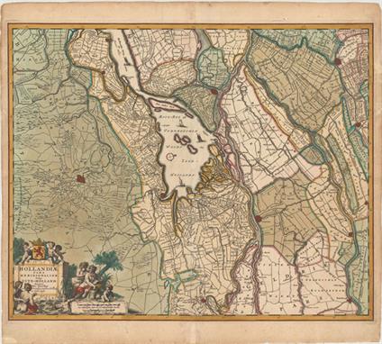
Visscher, Nicolas 1680 Hollandiae Pars Meridionalior, Vulgo Zuyd-Holland This attractive map is centered on De Biesbosch, now known as one of the last freshwater tide areas in Europe. The map extends to include Breda, Dordrecht, and Gouda. The tiny street patterns of the major cities are shown along with good detail of the surrounding provinces. A compass rose, several sailing ships, and a title cartouche featuring putti and a river god decorate the map. 22.4" W x 18.4" H Lovely original color that has been partially refreshed with light soiling, a professionally repaired centerfold separation at bottom, and several small chips and tears in blank margins that have also been professionally repaired..

Visscher, Nicolas 1680 Delflandia, Schielandia et Circumjacentes Insulae ut Voorna, Overflackea, Goerea, Yselmonda et Aliae, ex Conatibus Geographicis This detailed road map shows the estuary of the River Maas and extends from `s-Gravenhage to Gouda in the north and from Ouddorp to Steenbergen in the south. Cities, such as Rotterdam, Delft, and Brielle are depicted with miniature bird`s-eye plans. A compass rose orients north to the top right, and the map is further adorned with sailing ships, some engaged in battle, and a drape-style title cartouche held aloft by putti. 22.3" W x 18.3" H Lovely original color that has been partially refreshed, light soiling, professionally repaired centerfold separations at top and bottom, and faint damp stains that just enter map borders at right and left.

Ortelius, Abraham 1598 Schlavoniae, Croatiae, Carniae, Istriae, Bosniae, Finitimarumque Regionum Nova Descriptio, Auctore Augustino Hirsuogelio This is one of the earliest modern maps of the Balkans, covering present-day Slovenia and part of Croatia. It is based on the cartography of Augustus Hirschvogel who drew on the work of Lazarus, Ziegler, and Apian. There is good detail throughout, with villages, cities, rivers, and forests. An unusual compass rose, banner title across bottom, and a finely rendered galley ship in the Adriatic Sea make this an interesting composition. French text on verso. 18.2" W x 13.2" H Watermarked paper with wide, original margins, all edges gilt, and a few spots of foxing.
![Porcacchi, Tomaso 1576 [Lot of 17 - Greece] "This lot includes 17 maps of Greece and its islands published in Porcacchi`](http://lot-images.atgmedia.com/SR/36385/2893812/495-2013117142354_468x382.jpg)
Porcacchi, Tomaso 1576 [Lot of 17 - Greece] "This lot includes 17 maps of Greece and its islands published in Porcacchi`s “L`Isole piu Famose del Mondo”, all engraved by Girolamo Porro of Padua. Each map is on a full sheet of Italian text (7.0 x 10.5”). Size varies slightly. This lot includes: A. “Arcipelago”. Condition: A spot of printer`s ink residue and marginal soiling. (B+) B. “Il Sito de` Curzolari”. Condition: There are a number of cracks that have been closed on verso with archival tape and marginal soiling. (B) C. “Morea Penisola”. Condition: Light soiling and a few small worm holes in text below map. (B+) D. “Negroponte”Condition: Numerous minute pinholes along coastlines, light soiling, and manuscript writing in blank margins. (B) E. “Corfu”Condition: Light soiling with one small ink spot in image. (B+) F. “Milo”Condition: Light soiling with a few small worm holes in image at left. (B) G. “Zante”Condition: Light soiling with a printer`s crease above compass rose. (B+) H. “Scarpanto”Condition: Some soiling with a worm track in text below map. (B+) I. “Rhodi”Condition: Minor soiling. (B+) J. “Candia”Condition: There is light soiling, show-through of manuscript ink on verso, and a worm track in text below map. There is an old paper repair in right blank margin. (B) K. “Santorini”Condition: A couple of faint spots and a tiny worm hole in left blank margin. (B+) L. “Stalimene”Condition: Light soiling. (B+) M. “Metellino”Condition: Marginal soiling. (A) N. “Scio”Condition: Light soiling. (B+) O. “Nicsia”Condition: There are a few small worm holes in map at left, and an old paper repair in left blank margin. (B+) P. “Cefalonia”Condition: Light soiling with a small worm hole and ink stains in text below map. (B+) Q. “Cerigo”Condition: Light soiling with a worm track in text below map. (B+)" 5.5" W x 4" H See description.

Ortelius, Abraham 1574 Regni Neapolitani Verissima Secundum Antiquorum et Recentiorum Traditionem Descriptio, Pyrrho Ligorio Auct. This is a beautiful map of southern Italy with north oriented to the left as identified by the handsome compass rose. The map is filled with detail and based on the work of Pirro Ligorio who was best known as an architect involved in the building of St. Peter`s in Rome. The title is contained in a flowing banner and a fine sailing ship further adorns the map. Latin text on verso, published between 1574-75. 19.8" W x 14.5" H Watermarked paper with professional repairs to a centerfold separation that enters 2.5" into map at bottom and some small chips confined to blank margins. There are a couple of faded manuscript ink notations on map.

Fer, Nicolas de 1705 Plan de la Ville de Rome This bird`s-eye plan of Rome provides a fine view of the city, its expansive walls and the surrounding countryside. The Vatican with St. Peters and its beautiful gardens is visible at lower left, and the famous aqueducts are depicted below the cartouche. A compass rose orients the chart with north to the left and two extensive keys identify the important sites. 11.8" W x 9" H A small chip in bottom blank margin has been professionally repaired.

Jansson, Jan 1653 Cyprus Insula This superb map of the island of Cyprus is geographically based on the earlier work of Ortelius, and was first published by Blaeu in 1635. Its beautiful composition makes it one of the most desirable maps of the island. At top are two coats of arms; at center the arms of the House of the Lusignans, and at left the Turkish arms. The map is attractively arrayed with compass roses, sailing ships, and rhumb lines. The large cartouche at bottom right shows Aphrodite being drawn across the sea in a seashell chariot pulled by a pair of swans, while Cupid pierces her heart with an arrow. Spanish text on verso, published between 1653-66. 19.8" W x 15.1" H Attractive color with wide margins, light printer`s ink residue, and a professionally repaired centerfold separation that enters 3" into map at top. There is marginal soiling and a repaired tear in bottom blank margin near the centerfold.

Anon., 1700 Geographische Beschreibung von dem Wanderschaft der Apostelen und Reysen des H. Apostels Pauli... Very decorative map after Visscher describing the Apostle Paul`s travels by boat from Jerusalem to Rome showing the region from Sicily to the Persian Gulf. Graphic panels across the top and bottom depict 26 events from the Book of Acts, and the sea is filled with tiny ships and a compass rose. German text on verso. 18.5" W x 12.4" H There is light soiling, some show-through of text on verso, and some minor rippling of the paper.

Bellin, Jacques Nicolas 1740 Carte de la Coste d`Arabie, Mer Rouge, et Golfe de Perse This attractive map of Arabia and the Red Sea emphasizes the coastlines and the interior is primarily left blank. The shoals and navigational hazards in the Red Sea and the pearl banks off the coast of Bahrain are also noted. The map is nicely decorated with a title cartouche and a compass rose. 9.9" W x 8.7" H Watermarked paper with faint offsetting and some light mildew stains in blank margins just entering map at top left.

Kitchin, Thomas 1782 A New Map of China Drawn from Surveys Made by Order of the Emperor This later Kitchin map of China and its surroundings stretches from Tibet to the Sea of Japan, here called the "Sea of Korea". China is dense with detail, with mountains, provinces, rivers, and many cities noted. "Tay-wan or Formosa I.", "Nan-King", Canton, and the Gulf of Tonkin appear. There is a compass rose topped with a fleur-de-lis, two distance scales, a decorative title cartouche featuring figures in local dress near a massive vase, and a key at bottom left that translates regional geographic terms into English. 14.9" W x 13.3" H Issued folding with wide margins, faint offsetting, and light toning confined to the sheet`s edges.

Linschoten/Langren, 1595 Exacta & Accurata Delineatio cum Orarum Maritimarum tum Etiam Locorum Terrestrium quae in Regionibus China, Cauchinchina, Camboja sive Champa, Syao, Malacca, Arracan & Pegu... This influential map was the first published map of the Far East to be derived from Portuguese sources. Thus it is credited with breaking the Portuguese monopoly on the East Indian trade and was among the most important sources of information on Southeast Asia during the sixteenth century. The map is oriented with north to the left by two gorgeous compass roses. While based primarily on Portuguese portolan charts, Linschoten also drew on the cartographic work of Plancius. Southeast Asia and Japan are based on the cartography of Fernão Vaz Dourado, and China on the map of Barbuda. The Philippines is drawn from de Lasso with the curious orientation of Palawan. In other regions, Linschoten draws upon the reports of Marco Polo, most notably for the location of the mythical land of "Beach provincia aurifera"in the region where Australia would eventually be discovered. On the mainland, the course of the Mekong is placed too far west, significantly distorting the region and four large lakes in the interior are based on Chinese legend. "Corea" is shown as a large circular island. The map was beautifully engraved by Langren and is richly adorned with sea monsters and sailing vessels, along with a number of animals in the interior of China. Printed on two sheets, as issued. 20.6" W x 15.3" H A fine impression on watermarked paper with attractive old color that has been lightly refreshed. Issued folding, now pressed with professional repairs to a few tiny holes at fold intersections. There is some printer`s ink residue, overall light toning and soiling, and a tear in border at top left that has also been professionally repaired. Narrow margins.
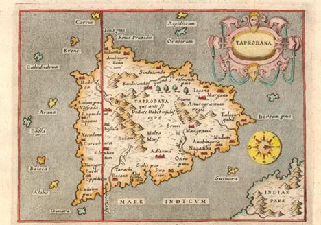
Porcacchi, Tomaso 1576 Taprobana Charming map of the island nation of Sri Lanka with north oriented to the right of the map. Only a bit of the Indian mainland is shown and it is incorrectly depicted to the east of the island. Strapwork title cartouche, an unusual compass rose and a stipple engraved sea combine to make this a very attractive map. Engraved by Girolamo Porro and printed on a full sheet (7 x 10.3") of Italian text. 5.5" W x 4" H Marginal soiling and manuscript ink above the map.

Apres de Mannevillette, Jean B. N. D. 1775 Carte de la Baye et du Port de Trinquemalay dans l`Isle de Ceylan Levee Exactement en 1762 par le Sr. Ge. Neichelson… This detailed nautical chart depicts the Bay of Trincomalee, a strategic sea port in the international trading history of Sri Lanka located on the northwest coast. The chart is fully engraved with great detail of the coastline and countless soundings, and features a legend identifying 23 locations, a compass rose and two views of the coastline. Columns of French text at left give detailed sailing instructions. Engraved by Guillaume Delahaye. 26" W x 19" H Watermarked paper with some light stains and a 2.5" tear at bottom right that has been closed with archival materials.

Child, G. 1745 A Chart of the Coast of Persia, Guzarat, & Malabar Drawn from the French Chart of ye Eastern Ocean An attractive copper engraved chart centered on the Arabian Sea that shows some of the Persian Gulf and the Gulf of Oman, extending past Persia to include half of India. The map locates the Maldives and many offshore islands and details capes, shoals, bays, and major harbors. The map is decorated with a compass rose with fleur-de-lys at center and a rococo-style title cartouche featuring a fountain, sea-horse, water nymph, and two wind heads. Engraved by G. Child. 7.8" W x 9.7" H Light offsetting.

Linschoten/Langren, 1596 Typus Orarum Maritimarum Guineae, Manicongo, & Angolae ultra Promontorium Bonae Spei … This is one of the most richly ornamented maps in early cartography, superbly engraved in the Flemish style by Arnold Florent van Langren. The cartouche contains a description of the region in both Latin and Dutch that credits the source as "the very best Indian maps" - referring to maps that Linschoten had access to when he was Secretary to the Portuguese Archbishop of Goa in India. The map covers the southwestern coast of Africa from the Gulf of Guinea to just beyond the Cape of Good Hope with excellent detail along the coastline. The fictitious cities of "Vigiti Magna" and "Monomotapa" are located and most place names and geographical features have Portuguese nomenclature. The mainland is embellished with snakes, an elephant, a rhinoceros, a lion and a pair of sirens in Lake Zaire. The balance of the sheet is filled with fabulous cartouches, the Portuguese arms, elaborate compass roses, sailing ships and a sea monster. The large bottom cartouche encloses views of Ascension and St. Helena Islands; important refueling ports in the route around Africa. 21" W x 15.5" H Issued folding on watermarked paper with light soiling and professional repairs to several fold separations, a binding trim and resulting 2.5" binding tear at left, and a 6.5" tear at left. There is also a professionally repaired area of loss along fold at top left with a minor amount of engraving in facsimile.
![Bellin, Jacques Nicolas 1739-60 [Lot of 3] Plan du Fort et de la Ville du Cap de Bonne Esperance [and] Coste Occidentale d`Af](http://lot-images.atgmedia.com/SR/36385/2893812/680-2013117143011_468x382.jpg)
Bellin, Jacques Nicolas 1739-60 [Lot of 3] Plan du Fort et de la Ville du Cap de Bonne Esperance [and] Coste Occidentale d`Afrique, Depuis le XIe. Degre de Latitude Meridionale... [and] Carte de la Baye de Sainte Helene Dressee sur les Remarques des Navigateurs "A. “Plan du Fort et de la Ville du Cap de Bonne Esperance”, circa 1760 (10.4 x 8.1”). Detailed plan of the Dutch fort and settlement at the Cape of Good Hope showing the town and fort with a key at bottom listing fourteen important locations. B. “Coste Occidentale d`Afrique, Depuis le XIe. Degre de Latitude Meridionale...”, dated 1739 (10.3 x 9.7”). Covers the southwestern coast of Africa extending from Benguela to the Cape of Good Hope, presenting coastal detail only. The map extends west to include St. Helena island. Adorned with a decorative title cartouche and a compass rose. Condition: Issued folding with a binding trim at bottom left that has been professionally replaced with old paper. C. “Carte de la Baye de Sainte Helene Dressee sur les Remarques des Navigateurs”, circa 1760 (6.4 x 8.3”). This chart of St. Helena Bay, just north of Cape Town, shows soundings, safe anchorages, shoals, and the topography of the coastline." #VALUE! Bright clean examples on watermarked paper. See description for additional details.
![Cook/Benard, 1780 Baye de Matavai a Otahiti [on sheet with] Havre d`Ohamaneno a Ulietea [and] Havre d`Owharre dans l`Isle d`H](http://lot-images.atgmedia.com/SR/36385/2893812/695-2013117143040_468x382.jpg)
Cook/Benard, 1780 Baye de Matavai a Otahiti [on sheet with] Havre d`Ohamaneno a Ulietea [and] Havre d`Owharre dans l`Isle d`Huaheine [and] Havre d`Oopoa a Ulietea Four well engraved charts on one sheet show protected bays on the islands of Otahiti (Tahiti), Ulietea, and d`Huaheine, with numerous soundings, shoals, and anchorages noted. Each features a compass rose and fleur-de-lys. 13.6" W x 8.6" H On watermarked paper with a chip in the top left chart that has been closed with archival material and faint offsetting.

Rand McNally & Co., 1902 Rand, McNally & Co.`s Universal Atlas of the World... This nearly complete atlas contains 82 single-page and 37 double-page maps (missing only the maps of Puerto Rico and United States Acquisitions, in addition to the title page). All double-page maps are printed on two sheets. Although this is a world atlas, the majority of the maps are of U.S. interest, including all states and territories and numerous city plans. The atlas is illustrated with dozens of black and white photographs interspersed throughout the text, including presidential portraits and a facsimile of the U.S. constitution. Introduction, table of contents, text and maps, 461 pp., including an exhaustive 92 pp. listing of towns and counties for each state. This example does not contain the "History of the Spanish-American War with Handy Atlas Maps and Full Description of Recently Acquired United States Territory" supplement sometimes seen at the back of these atlases. Hardbound in original green cloth with blue cloth spine and leather tips. Gilt and embossed title to cover with graphic elements including a compass rose and sailing ship. 11.5" W x 13.3" H Condition code is for the maps which are generally very good with some light toning and a very thin damp stain in the top blank margin away from the images. Contents are tight, the covers are loose and starting to detach, and the extremities show some wear with two small chips in the front cover. The perished spine has been replaced with a denim cloth material.


Air meter by `Negretti & Zambra`, in wooden box with an instruction leaflet for "Correction for Air Meter No. 549, a brass cased compass by `Charles Augustus Schmalcalder`, with hinged wire carrier, wire snapped off & prismatic sights, approx. 70mm diameter, green dial, inscribed "Schmalcalder`s, Patent & No. 82 Strand, London" base stamped `294B`& & inner of base stand stamped `294B`, with ball joint & slide in holder, in good condition, complete with original box, box in very poor condition & falling apart & a compass by `Short & Mason Ltd, London`, approx. 55mm, mother of dial ring around dial, No. 9263 & 1915 stamped on base, well used condition (3)


A terrestrial table globe 'The Earth', early 19th century, J. G. Klinger, Nuremberg, made up of twelve hand coloured engraved gores, depicting geographical information, the equator, elliptic and prime meridian graduated, tropic of Cancer and Capricorn, Arctic and Antarctic Circles, titled 'The Earth', published by J. G. Klinger in Nuremberg, constructed, delineated and etched by J. A. Buhler, the turned stand with paper horizon graduated with compass points, months of the year, and corresponding zodiac signs, 25cm high, 5½in diameter CONDITION REPORT: Indent on equator by South America. Signs of old repairs. Stand probably later.


A gold ring, mounted with three oval opals and with two pairs of small diamonds at intervals, detailed `18ct`, with a case, a gold and diamond set single stone ring, mounted with a circular cut diamond, a 15ct gold ring set with three rose diamonds (two rose diamonds lacking), Chester 1885, and a pendant compass fob.


A silver pair cased open-faced gentleman`s pocket watch, the gilt fusee movement with a verge escapement and a scroll pierced and engraved balance cock, the back plate detailed `Wm Atwood Lewes 6024`, the enamelled dial with large black Roman numerals, London 1836, with a key, and a gold mounted compass pendant fob designed as a ship`s wheel, detailed `10`.


commemorative, commemoratives, commemorate, military, naval 1797 Sir Horatio Nelson: a very rare creamware jug the bellied body printed in black with a named portrait oval and on the reverse a compass, 131mm, spout restored and hairline crack Illustrated * Following the Battle of Cape St Vincent in 1797 Nelson was made a Knight of the Bath, later the same year he lost his arm at the Battle of Santa Cruz de Tenerife This print is quite possibly the first event for which Nelson was commemorated.


-
33014 item(s)/page