We found 36558 price guide item(s) matching your search
There are 36558 lots that match your search criteria. Subscribe now to get instant access to the full price guide service.
Click here to subscribe- List
- Grid
-
36558 item(s)/page


Lot 131
A fine 19th century gentleman artist`s box, kingwood and tulipwood with brass inlay, containing a silver gilt folding paintbox, by Charles Rawlings and William Summers, London 1838, of rectangular form, when opened revealing two palettes, with twenty sections for watercolour paints, 21cm x 9.25cm x 1.5cm when closed, and 21cm x 27cm when open, in addition a silver gilt rectangular cover, by Charles Rawlings and William Summers, London 1838, 8.5cm x 9.5cm, both pieces engraved with scrolling foliage and a coat of arms with motto below, also fitted with an ivory rolling ruler, by Wells and Lambe, London, and a circular ivory compass, by Thos. Rubergall, Optician to Their Majesties, a pen, pencil and knife, a steel geometry set, a gilt tooled leather bound book (blank), under this a watercolour paper pad and a gilt tooled leather blotter. The arms are those of Baron Greville of Clonyn Co. Westmeath. Colonel Fulke Southwell Greville-Nugent, 1st Baron Greville (17 February 1821 - 25 January 1883) was an Irish politician, born Fulke Southwell Greville. He was the son of Capt. William Fulke Greville, and the grandson of Fulke Greville. He married Lady Rosa Emily Mary Anne Nugent, only daughter and heir of George Nugent, 1st Marquess of Westmeath. They had six children. The arms are those of a baron, but the Greville barony was not created until 1869 for Fulke Southwell Greville-Nugent of Co. Westmeath, and for much of the early period of this peerage the family used the name and arms of Nugent. (Fulke Greville was the First Lord Brooke in the 17th century)

Lot 144
An 18th Century Eight Day Longcase Clock. The 12 inch (30.5 cm) square brass dial signed Ashton TIDSWELL on the chapter ring with engraved fleur-de-lys between the Roman numeral hour counters and outer ring of Arabic minute counters. The matted centre engraved with foliate scrolls and a compass rose, incorporating a subsidiary seconds dial and calendar aperture. The corners embellished with scrolling floriate spandrels. The oak case having a flat topped hood with moulded pediment raised on Doric columns flanking the dial. The cross-banded trunk inlaid with a compass rose. The base with alteration, 79 ins (201 cms) in height.

Lot 399
A 19th Century Ormolu & White Marble Clock Set. The dial signed J.Vicat, Palma, enclosed by a bevelled glass door and surmounted by a globe, compass & rule. The movement flanked by seated cherubs reading astrological books above the marble breakfront base 14½ ins (37 cms) in height, 19 ins (49 cms) in width, 6 ins (15 cms) in depth. The four branch candelabra held aloft by winged cherubs.

Lot 434
A Fabulous Quality Late 19th Century Edwards & Roberts Bookcase. The crested cornice having a pierced fret-work swan neck pediment above an inlaid band of faux-dentil moulding and a frieze of inlaid rosette roundels bordered in stringing. The three large glazed doors applied with astrigal mouldings of geometric design, enclosing height adjustable shelves. The lower cupboard doors enriched with marquetry panels; the middle panel centred by a group of musical instruments, compass & manuscript within an oval bordered by laurel branches and bell flower swags. The flanking panels having detailed marquetry pen-worked cornucopia of fruits flanking crossed sprays of wheat. Raised on four bracket feet. Stamped `Edwards & Roberts` with two labels to the reverse each stamped `Gretton` and in ink `48` relating to Lord and Lady Gretton estate (Stapleford Park, Leicestershire). 107 ins (272 cms) in height, 72 ins (184 cms) in width, 18 is (46 cms) in depth.


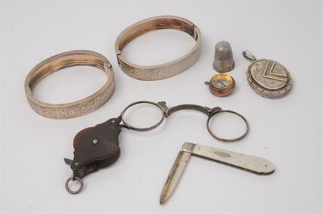
Lot 1272
A seal pendant with a compass terminal, a rectangular pewter hinge lidded box, a Mummy case charm, enclosing a Mummy, two miniature albums of commemorative photographs, two white miniature ceramic jugs, a sewing set formed as an egg in a egg cup, a button brooch, with a locket compartment, a folding button hook and seven further items.

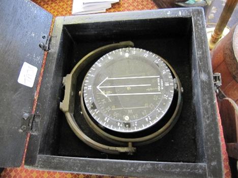
Lot 4
SHIP’S BINNACLE “SESTREL” BY HENRY BROWNE AND SON. TYPE 89521 COMPASS NO 2944N the cylindrical oak frame surmounted by the copper compass top with glass windows and two copper handles, with two iron brackets bolted to the cylinder with two cast balls on either side above a measuring scale, a spirit level contained in a brass case screwed to the front, a cast brass plaque compass No 2944N, the base with four slots for attaching to the deck 54in. (137cm) high


Lot 129
AN EARLY 20TH CENTURY LACQUERED AND PATINATED BRASS THEODOLITE, by Stanley, London, number 25193, the mounted spirit level sighting tube pivoted between two uprights with vernier scale, the rotating calibrated compass inset plinth applied with spirit level and signed STANLEY, LONDON 25193, on a platform base with levelling screws, marked Stanley`s patent. 41cm(h)

Lot 160
AN EARLY 20TH CENTURY BRITISH ARMY NAVIGATION TOOL by Houghtons Ltd, London, the shaped top with inset compass over a adjustable paper scroll devise, engraved scales to top and base, the reverse with protractor and leather strap, the base stamped Houghtons Ltd London 1908 IV 949, along with crows foot military mark. 25cm(h) x 18cm(w)

Lot 194
AN IVORY DIPTYCH POCKET SUNDIAL of hinged rectangular form, the top having a central circular depiction of the sun surrounded by points of the compass and a pierced aperture over north, all within engraved foliate borders, opening on wire loop hinges to reveal a glazed compass, string gnomon and various scales, marked `Albrecht Karner 1662`, the base with conforming engraved foliate decoration surrounding a circular dial with multiple bands, marked at the hinge with a hunting horn type mark struck twice, small brass feet to each corner. 9.3cm(L) x 5.7cm(w)


Lot 296
Labrador, a Swiss half hunting cased keyless wind pocket watch, .935 standard, the white dial with Roman numerals, gilt spade hands and subsidiary seconds dial, in a plain case with black Roman numerals; Waltham, Traveller, a rolled gold hunting cased keyless wind pocket watch, no. 12624138, the white dial with Roman numerals, gilt spade hands and subsidiary seconds dial, in a plain case; Waltham, a nickel open face keyless wind pocket watch, with screw down bezel; and a military compass, the plain nickel case by Dennison with War dept. markings, no. 72816 and dated 1916 (4)

Lot 161
* Cumberland & Westmorland. Jansson (Jan), Cumbria & Westmoria vulgo Cumberland & Westmorland, n.d., c.1650, hand coloured engraved map, elaborate cartouche and mileage scale, compass rose and numerous rhumb lines, 425 x 545mm, mounted framed and glazed, together with,Ducatus Eboracensis Pars Orientalis, The East Riding of Yorke Shire, n.d. c.1650,hand coloured engraved map, elaborate cartouche, heraldic shields, compass rose and numerous rhumb lines, 380 x 505mm, mounted, framed and glazed. Not examined out of frames. (2)

Lot 168
Estate Plan. An Accurate Survey and Plan of two Farms of Land lying the one at East and the other at West Barnby belonging to Mr. Thomas Fishburn. Made Anno 1781, by L.Charlton Philomath. fine original ink and watercolour manuscript map on laid, with compass rose and scale of chains, laid on near contemp. hessian, slight fraying to margins, 520 x 720mm. The map shows two farms, their fields and the acreage of each, belonging to Thomas Fishburn, situated near the hamlets of East and West Barnby about five miles North West of Whitby in Yorkshire. Thomas Fishburn was a shipwright and owned a ship building yard at Whitby and in June 1764 he built and launched a ship called “The Earl of Pembroke”. This ship was purchased by the Royal Navy in March 1768 and was re-named “HMS Endeavour”. HMS Endeavour was the ship which was given to a newly promoted Lieutenant James Cook, who was to sail her on one of the most famous voyages of discovery ever undertaken. His voyage to Australia and New Zealand; the “Terra Australis Incognita” or the unknown Southern land in the years 1769 to 1771 has become the stuff of legend and Cook’s celebrated reputation as a commander, navigator, cartographer and explorer is arguably second to none. Cook was to return a national hero and was promoted to Commander. HMS Endeavour ended her days as a worn out troop transporter and prison ship in New Port, Rhode Island. Her final resting place is unknown for in the final ignominy she was towed out to the entrance of Newport harbour and in an attempt to frustrate ships carrying French troops she was scuttled in Narragansett Bay. (1)

Lot 181
Hampshire. Greenwood (C. & J.), Map of the County of Southampton from an actual Survey, made in the Years 1825 & 1826 by C. & J. Greenwood, most Respectfully Dedicated to the Nobility, Clergy, & Gentry of Hampshire, by the Proprietors, June 15th. 1826, engraved map with original hand colouring, sectionalised and laid on linen on three sheets, bright original hand colouring, calligraphic title, compass rose, table of explanation and engraved vignette of the South East view of Winchester Cathedral, each section bordered with contemp. green silk, overall size approx. 1590 x 1420mm, contained in near contemp. qtr. calf gilt solander box, rubbed and worn (1)

Lot 622
An early 20thC mantel clock, with timepiece movement, the two part dial with cream chapter and Arabic numerals, embossed to the centre with a classical figure in a landscape, the fabric covered case with embossed gilt metal fascia of putti and goat amongst meandering ivy, and mounted with a compass, thermometer and barometer tube, raised on scroll feet, 22cm high.

Lot 1
Bradford. Dixon (Thomas), Map of the Borough of Bradford, Comprising the Townships of Bradford, Bowling, Horton & Manningham, from Actual Surveys made in the Years 1844, 1845 & 1846, Bradford, June 1846, large engraved map, sectionalised and laid on linen, bright original outline colouring, calligraphic title, compass rose, table of reference and engraved vignette of Bradford Infirmary, 1140 x 1420mm, contained in orginal gilt cloth slip case with blind embossed arabesque on both boards, gilt title to spine, together with, Mawson (H. O. pubs.), Map of Forty Miles Round Bradford, n.d. c.1860,engraved map with original hand colouring, sectionalised and laid on linen, 980 x 1260mm, marbled end papers, comtemp. gilt sheep boards, rubbed, worn and frayed (2)

Lot 2
Bryant (A.). Map of the East Riding of Yorkshire from actual Survey by A. Bryant in the Years 1827 & 1828, pub. May 2nd. 1829, large engraved map sectionalised and laid on linen on four sheets, each sheet bordered in green silk, calligraphic title, compass rose, table of explanation and a table of the Ecclesiastical Division, engraved vignette of Beverley Minster, each sheet approx. 645 x 755mm, contained in contemp. morocco gilt solanader box, rubbed and worn at extrems. (1)

Lot 7
* Enclosure Records. Two awards and four maps relating to Skipton, Kildwick, Stirton with Thorlby and Silsden, dated 14th December 1774, manuscript with text on eight large (and one small) vellum sheets and extinguishing vicarial tithes in Skipton with Thorlby and Silsden, and awarding lands to the Vicar of Skipton and the Vicar of Kildwick, tied with four related pen and ink large sheet maps on vellum of Skipton Ings, a part of Silsden Moor (two sheets) and Rumbles Moor, scale of 10 or 20 poles to 1 inch, surveyor not named, hand-col. compass and rule to each map, the largest map approx. 71 x 154mm and the others sl. smaller, one further leaf of oaths stitched at front, overall somewhat dust soiled, rubbed and creased with some loss to upper outer corner of first text leaf, three wax seals with signatures of John Heelis, Thomas Watkinson and Richard Clapham. Another copy of these enclosure records are held by North Yorkshire County Record Office, ref. WRRD B 10. (1)

Lot 10
Hobson (William Colling). This Map of Yorkshire is most respectfully dedicated to the Nobility, Clergy, Gentry, Landowners and Manufacturers of the County, pub. William Colling Hobson, Sept. 1843, engraved map with original outline colouring, sectionalised and laid on linen, on two sheets, calligraphic title, compass rose and table of explanation, each sheet approx. 1255 x 760mm, orig. cloth with gilt decorated upper board and spine, steel clasp, rubbed at extrems. Brian Kentish, A Catalogue of County Atlases of England and Wales 1607-1868 and Large Scale County Maps, item no. 78. (1)

Lot 18
Leeds. Martin (S. D.), Map of the Country extending ten miles round Leeds, including Wakefield, Bradford, Dewsbury, Otley, Harewood, Aberford & Castleford, shewing all the Parish and Township Boundaries &c., ..... re-surveyed & corrected to January 1st. 1849 by Martin & Fox, Surveyors, Leeds, engraved map with original hand colouring, sectionalised and laid on linen, calligraphic title, compass rose, table of explanation and vignette of Kirkstall Abbey, 1130 x 1230mm, contemp. morocco boards with gilt dec. upper board, steel clasp, rubbed and frayed. Brian Kentish, A Catalogue of County Atlases of England and Wales 1607-1868 and Large Scale county Maps, item 79. (1)
Lot 29
Tuke (John). Map of the County of York, 1787, large engraved map with original hand colouring, sectionalised and laid on linen, elaborate title cartouche, inset town plan of Kingston upon Hull, inset scale map of the county and table of explanation, toned overall, 1180 x 1425mm, together with Coltman (Nathanial),Laurie & Whittle’s New Map of the County of York, laid down from Astronomical Observations Published in the Philosophical Transactions, divided into its Ridings with their Subdivisions Exhibiting the whole of the Mail, Direct & principal Cross Roads, Navigable Canals, Rivers &c. &c., 1806,engraved map with original outline colouring, sectionalised and laid on linen, compass rose and list of Wapontakes, 530 x 695mm, contained in contemp. marbled slip case with orig. printers label to upper board, worn at extrems., with, Bowen (Emanuel),An Accurate Map of the County of York Divided into its Ridings and Subdivided into Wapontakes, pub. John & T. Bowles, [1764 or later],engraved map with original outline colouring, sectionalised and laid on linen, elaborate cartouche, toned overall, 545 x 715mm, contained in orig. marbled slip case with printers label to upper boad, rubbed and frayed, with, Rowe (Robert),A New Map of Yorkshire Divided into Ridings &c. June 4th 1810,engraved map with original hand colouring, sectionalised and laid on linen, 685 x 840mm, slight off setting, contained in orig. marbled slip case, rubbed, frayed and worn, together with another three folding maps similar (7)
Lot 30
Yorkshire. Cruchley (G.F.), Cruchley’s Railway & Telegraph Map of Yorkshire Showing all the Railways & Names of Stations, also the Telegraph Lines & Stations Improved from the Ordnance Surveys, n.d. c.1865, folding lithographic map with original outline colouring, calligraphic title, some near contemp. ink annotations,485 x 545mm, orig. printed paper wrappers, contemp. ink ownership inscription, slight fraying, together with Collins (H.G.),Yorkshire, n.d. c.1858,folding lithographic map with original outline colouring, sectionalised and laid on linen, slight staining, 700 x 870mm, orig. cloth with printed label to upper board, with,Harding (J.W. & Co. pubs.),Map of Huddersfield District, 1922,decorative folding colour printed map, margins with colour printed advertisements for local businesses, 745 x 550mm, orig. printed paper wrappers, with Sampson (John pubs.),Map of the York and Ainsty Hunt Dedicated by Permission to Captn. Slingsby, Scriven Park, and Members of the Hunt, York, 1881,colour printed lithographic map, sectionalised and laid on linen, compass rose, list of meets and explanation table, 860 x 960mm, comtemp. gilt and blind embossed cloth boards, together with another thirteen folding maps, various sizes and condition (15)
Lot 31
Yorkshire. Baines (Edward, pubs.), Map of the East & North Ridings of the County of York, Including the latest Improvements, Engraved for the History and Directory of Yorkshire, Leeds, 1822, engraved folding map laid on linen, calligraphic title and table of explanation, bound with Neele (Samuel John),Kingston upon Hull with its Environs, 1823,engraved folding map laid on linen, calligraphic title, table of reference, topographical vignette and three heraldic shields, 255 x 300mm, bound with Neele (Samuel John),York, 1822,engraved folding map laid on linen, engraved topographical vignette and table of reference, 310 x 260mm, bound with Baines (Edward, pubs.),Map of the West Riding and Ainsty of the County of York, Engraved for the Directory, 1822,engraved folding map, laid on linen, calligraphic title and compass rose, 415 x 530mm, bound with folding town plans of Leeds & Sheffield, and two triangular mileage table for Yorkshire and for England and Wales, book plate of P.Hornby Apothecary & Druggist, York, orig. end papers, hinges strengthened, contemp. diced calf, rebacked, large 8vo, together with Hall (Sidney),Yorkshire, n.d. c.1835,engraved map with original outline colouring, sectionalised and laid on linen, slight dust soiling, 255 x 370mm, bound in orig. gilt boards, together with Cary (John),A New Map of Yorkshire Divided into its Ridings and Wapontakes Exhibiting its Roads, Rivers, Parks &c., 1818,engraved map with original hand colouring, sectionalised and laid on linen, marbled end papers, 485 x 535mm, contained in orig. slipcase with printed label to upper board, with another four maps similar (8)

-
36558 item(s)/page