We found 3964 price guide item(s) matching your search
There are 3964 lots that match your search criteria. Subscribe now to get instant access to the full price guide service.
Click here to subscribe- List
- Grid
-
3964 item(s)/page


Lot 167
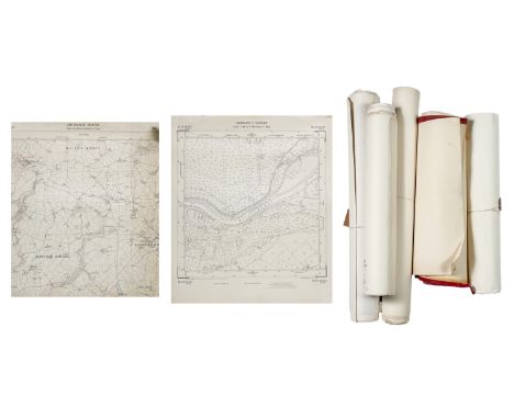
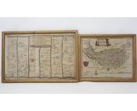
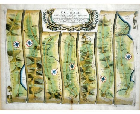
Some with colour pencil additions from Hooper, in varying condition but mostly vg, all rolled. (Q)Including;0.5 1908 25 inch Scorrier and Wheal Rose, marked with lodes 0.5; 1974 Sheet 74 SW 74 St Day; 0.5 1963 Sheet SW 74 SW 6” St Day; 0.5 1890 Perranporth Rose, Gear Sands; 0.5 1908 25” North Country to Wheal Reevor marked with lodes; 0.5 1908 25” Redruth (S,W) to Carn Brea; Photocopy of 589 Overlaid with 1960s development; Photocopy 1908 25” 0.5 map Treleigh and Plain an Gwarry overlaid 1960s development; Photocopy part 0.5 25” map Shades bridge and Kestle Quarry; 0.5 1890 6” Perranporth; 0.5 1963 6” Redruth and St Day SW74SW; 0.5 1974 6” Redruth and Sat Day SW74SW with contours; 0.5 1908 25” Wheal Rose, Scorrier, Killifreth. Underground adits, including country adit marked in red; 0.5 1908 25” Redruth North (Plain An Gwarry, Treleigh) with laker housing superimposed; 1908 25” Redruth South Carn Brea Village Trewirgie, Victoria Park; 1908 25” Redruth North Country and Wheal Reevor, underground adits marked; 1908 25” Relubbus (left handed half); 0.5 1908 25” Goonlaze (Stithians parish); 0.5 1908 25” Brea Village, Condurrow, Treskillard, Carn A and then Piece; 0.5 1908 25” Tregonning Hill, Great Work Mine, Balwest, marked with a straight blue line; 0.5 1907 25” Navax Point, Hells Mouth, Hudder Downs, some fields coloured red; 0.5 1908 Part 0.5 LXXIV.8 Part Mounts Bay, The Greeb, Maen du Point; 0.5 1907 25” St Stephens Coombe Resugga; 0.5 1908 25” Pendarkes House, Treslothan, Ramsgate; 0.5 1908 25” Four Lanes; 0.5 1908 25” Mounts Bay, Methleigh, Tranno, Tremearne; 0.5 1908 25” Woon Gumpas Common with Penwith Boswens Common; 0.5 1907 25” Burnthouse, Laity moor, Roskrow (St Gluvias); 0.5 1936 25” Germae Tresowes Green; 0.5 1936 25” Kenneggy Downs and Kenneggy Sands; OS 50’ Copy SW 6539 SE 1967 Vivians Shaft Beacon;OS 25’ Copy SW 6439/59 Tregenna Lane, Camborne;OS 25’ Copy 6239/6339 Penponds;OS 50’ SW 6339 NE Camborne Rugby Ground;OS 50’ SW 6439 SW Barripper Road, Pendarvis Road;OS 50’ SW 6439 NW Tregurthen Road, Tregenna Lane;OS 50’ SW 6841 SE (photocopy) Carn Brea Mine, Carn Brea;OS 50’ SW 6841 SW (photocopy) Barncoose, Carn Brea;OS 50’ SW 6340 NW (photocopy) Weeth Road;OS 50’ SW 6340 NE (photocopy) Weeth Road;OS 50’ SW 6440 SE (photocopy) central Camborne Town;OS 50’ SW 6741 SW Carn Brea Leisure Centre;OS 50’ SW 6741 NW (photocopy) Flamingo, Taylors Shaft;OS 50’ SW 66 (photocopy) Pool School;OS 50’ SW 6641 NW (photocopy) A30 Junction Tolvadden;OS 50’ SW 6641 (photocopy) South Crofty, SWEB, Pool;OS 50’ SW 6641 (photocopy) Robinsons Shaft;OS 50’ SW 6640 Camborne Central;OS 50’ SW 6539 NE (photocopy) Pengegon;OS 50’ SW 6539 NW Stray Park;OS 50’ SW 6539 SE Beacon x 3;OS 50’ SW 6540 SW Wesley Street, Holmans;OS 50’ SW 6541 SE North Roskear;OS 50’ SW 6540 NE Roskear, Tuckingmill;OS 50’ SW 6440 SW College Street Camborne;OS 50’ SW 6540 SE Dolcoath, Pengegon;OS 50’ SW 6440 NW Reskadinnick Road;OS 50’ SW 6539 SW Trevu Road;OS 50’ SW 6640 NW Chapel Road, Tuckingmill;OS 50’ SW 6440 NW Enys Road;OS 50’ SW 6439 SW Mount Pleasant Road;OS 50’ SW 6439 NE Camborne Library;OS 50’ SW 6339 SE Penponds;OS 50’ SW 6340 NE Weeth Road West;OS 50’ SW 6340 SE Treswithian; OS 50’ SW 6540 NW North Roskear TA Centre;OS 25’ SW 6440–6540 Camborne;OS 50’ SW 6441–6741 Tuckingmill, Pool. (Q)From the estate of Ron Hooper, M.V.O., A.C.S.M., F.I.M.M.Born in St.Agnes, he graduated from Camborne School of Mines. After a short career mining in the Gold Coast of Ghana he joined the Camborne School of Mines, eventually becoming Senior Lecturer in Surveying. At the same time, he acted as an independent mining engineer and was appointed mineral agent for several Cornish estates including the Duchy of Cornwall, Tregothnan, and the Godolphin Estate (amongst others).
Lot 164
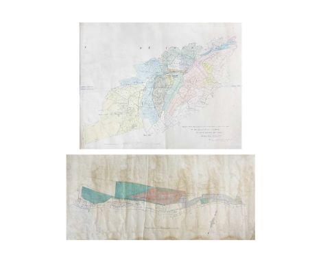
'Trenwith Mine, St Ives,' Surveys and maps by Leonard Hawkey, 1911. Hand drawn cross sectional survey on thin linen by L. Hawkey, scale 1 inch to 5 fathoms, showing Victory Shaft, Berriman Shaft and Old Sump Shaft, reference of Adit Level, damp staining to edges, colour ink offsetting, rolled, approx 75cm x 215cm, 1911; 'Longitude Section', scale 1 inch to 5 fathoms, damp staining and nibbles to edge, rolled, approx, 75cm x 220cm [L. Hawkey, 1911]; Handrawn map on linen, with scale and compass, showing mine burrows, Stennack Road and Trenwith Terrace, damp staining, rolled, approx, 65.5cm x 143cm, [L. Hawkey, 1911], '....Berriman Shaft, Transverse Section,' hand drawn, scale 1 inch = 30 feet or 5 fathoms, damp staining to edges, approx 56cm x 21cm on much larger thin linen, rolled, [L. Hawkey, 1911]; With the same for 'Old Sump Shaft' and 'Victory Shaft'; Hand drawn survey both transverse and longitudinal sections for 'East Virgin Shaft and Sump Shaft', on linen with damp staining to edge, rolled, approx 68cm x 100cm, [L. Hawkey, 1911]; 'St Ives. Ordnance Map to show Leases and accompany Report of October 8th 1907,' tears and nibble to edges, rolled, approx 88cm x 109cm. (8)Surveyed by Hawkey during the reopening of the mine, by the German-owned 'British Radium Company' for the extraction of uranium (and radium). A fascinating survivor of subterranean St. Ives. From the estate of Ron Hooper, M.V.O., A.C.S.M., F.I.M.M.Born in St.Agnes, he graduated from Camborne School of Mines. After a short career mining in the Gold Coast of Ghana he joined the Camborne School of Mines, eventually becoming Senior Lecturer in Surveying. At the same time, he acted as an independent mining engineer and was appointed mineral agent for several Cornish estates including the Duchy of Cornwall, Tregothnan, and the Godolphin Estate (amongst others).
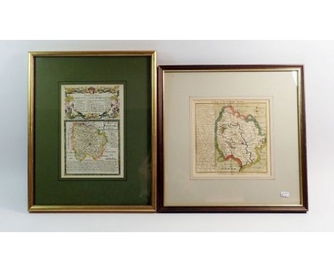
Lot 224
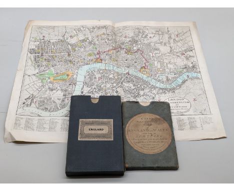
MAPS: Darton & Harvey (publisher): 'London Westminster and Southwark shewing the various alterations...': 1804, copper engraved map with hand colouring, 46 x 58cm, vertical centre fold, light toning and creasing, a few short tears and chips to margins: together with 'Cary's Reduction of his Large Map of England and Wales, with part of Scotland, containing the whole of the Turnpike Road, the principal rivers & the course of the different navigable canals..', printed by J Cary, 1805: folding map laid on linen, slipcase with printed label, a little rubbed and marked: with another 19thc folding map. (3)
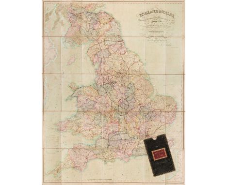
Lot 47
England & Wales. Walker (J & C), England & Wales founded upon the Grand Trigonometrical Survey, Shewing all the Mail Coach, Turnpike & Rail Roads, the Rivers & Navigable Canals, also the Boundaries & Divisions of Counties..., circa 1850, engraved map with contemporary wash colouring, sectionalised and laid on linen, slight staining and spotting, calligraphic title and table of explanation, 1300 x 1030 mm, contained in a contemporary green morocco gilt slipcase with red morocco gilt label to the upper cover, some wear to extremities, together with another copy similar (dated 1845) with some offsetting from the calligraphic title, contained in a contemporary cloth slipcase, with Wyld (James. successor to Mr Faden). A New Map of England & Wales Projected upon the Trigonometrical Operations made for the General Survey of the Kingdom, January 1st 1836, engraved map with contemporary wash colouring, sectionalised and laid on linen, table of the 'Altitudes of the Principal Mountains', and table of explanation, slight offsetting, edged in green silk, advertisement endpapers, 1250 x 950 mm, contained in a contemporary cloth slipcase with publisher's printed label to the upper cover, slipcase worn and frayed, plus Mogg (Edward). Map of the United Kingdom of Great Britain & Ireland with the adjacent parts of the Continent from Amsterdam to Paris and Brest..., January 1st 1834, engraved map with contemporary wash colouring, sectionalised and laid on linen, with an additional title above the map 'Mogg's Map of Steam Navigation', inset map of the Shetland and Orkney Islands, table of reference and compass rose, very slight staining, 770 x 610 mm, advertisement endpapers, contained in a contemporary blue card slipcase with publisher's printed label to the upper cover, slipcase worn and frayed at extremities, and Sayer (Robert). An Accurate Modern Map of England and Wales, drawn from the latest Surveys, Corrected & Improved by the Best Authorities, circa 1775, an engraved map with contemporary outline colouring, sectionalised and laid on linen, some staining and dust soiling, slight wear where old folds cross, 480 x 405 mm, contained in a contemporary marbled card slipcase with a near-contemporary manuscript ownership signature to the upper cover, slipcase worn and frayed, with Wyld (James). Wyld's Road Director through England and Wales being a New and Comprehensive Display of the Roads and Distances from Town to Town and of each Remarkable Place from London, 1851, lithographic folding map with contemporary outline colouring, laid on linen, slight offsetting, bound in contemporary cloth boards with publisher's label to the upper cover, some wear to extremitiesQTY: (6)


Lot 397
A miscellaneous collection of books and maps to include James Riddell, 'The Ski Runs of Switzerland', Arnold Lunn, 'The Complete Ski-Runner', Charles Gos, 'Alpine Tragedy', Raymond Flower, 'The Story of Skiing and other Winter Sports', together with ten folding maps to include Bacon's County Map of Devonshire, and a Geographia Road Map of South Devon (14)
Lot 400
A collection of books on Topography, Royalty, Art etc, together with printed ephemera to include theatre programmes and maps, to include an Ordnance Survey map of Northwich and Macclesfield, a W. H. Smith and Sons, 'Map of Environs of London', a Bartholomew's map of 'Cheshire', 'The Contour Road Book of England, Northern Edition' and others

Lot 25
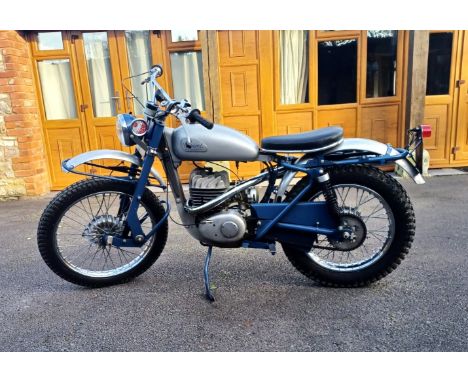
1960 Greeves Scottish Registration Number: YYW 476 Frame number 1791 Engine Number 2225H291F1329 The name Greeves is famous for competition machines in the 60s and 70s. The company was founded by Bert Greeves, producing a range of road and later competition bikes. Their trademark was cast beam downtube and rubber-in-torsion leading link forks, proved adaptable to almost all forms of motorcycles from the humble commuter to clubmans road racer, but it was the firm's off road products which really put Greeves on the map. The off-road range was extensively revised for 1958, gaining new frames with increased ground clearance, together with a narrower rear subframe and swinging arm. This 1960 model, fitted with the famous Villiers starmaker engine, has been with our vendor for over 20 years, and is described as in good running condition. Road registered, with current V5c, this would make the ideal motorcycle for classic trials events.
Lot 911
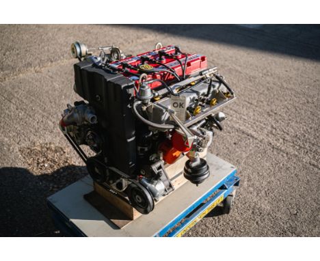
From the 'DJH Ford Collection', an original, unused/uninstalled factory bench-tested RS500 engine; 'automotive art' or as a spare, either way it's magnificent. The Sierra RS Cosworth might have been the first Ford to be honoured with the Cosworth name, but the relationship between the two companies dates back to the 1960s when the American car producer funded the development of a 3-litre V8 engine for Lotus' F1 car. The resulting V8, known as the DFV, then went on to be a dominant engine in Formula 1 for over a decade, winning 155 Grand Prix.Despite reigning supreme on track and in rallying throughout the decade, by the end of the 1970s, Ford’s motorsport dominance was on the wane. Even the once all-conquering Ford-Cosworth DFV Formula 1 was starting to lose out to more modern turbocharged units. This was painfully obvious when a Ford VIP contingent visited the 1983 British Grand Prix at Silverstone, where a Touring Car race supported the main event and Ford bosses, Stuart Turner and Walter Hayes, were dismayed to witness a group of Capris being humbled by SD1s with Rover V8 power.The solution was again to be found with the engineers at Cosworth who had previously developed a four-cylinder engine for Ford's racing and rallying saloons in the late 1960s and 1970s. The Mk1 Escort RS1600, which replaced the Lotus-powered Twin Cam Escort, had a 1,600cc engine with a 16-valve head designed by Cosworth called the 'BDA'.The formula for the Sierra wasn’t dissimilar to that of the earlier homologation Escorts and Cosworth and the trusted cast iron block from Ford’s single-overhead cam, the T88 Pinto that was used in the Escort RS2000, was utilised to form the basis of this new engine. Code named 'YAA', Cosworth designed an aluminium head to suit the Pinto block with two belt-driven cams operating 16 valves; eight 35mm diameter inlet valves and eight 31mm exhaust. Compared with the basic Pinto, almost everything changed except for the cylinder block itself and the new head and valve gear were matched to a new steel crankshaft, rods, pistons, and sump, and hydraulic valve lifters were a given. A turbocharger was always part of the plan and a Garrett AiResearch T3 with an intercooler were selected boosting power to 201bhp at 6,000rpm and 205lb/ft at 4,500rpm, in road car spec.With a new facility to produce the production-ready version (now with the 'YB' prefix), the first prototype started test-bed work in Northampton in June 1984 although the first engines and test cars didn’t go to Weber-Marelli in Italy until September 1984 before subsequently being 'signed off' by mid-1985.First utilised in the 3-door Sierra RS Cosworth of 1986 - introduced for homologation to allow Ford to go 'Group A' Touring Car racing - the new production 1,993cc YBB engine proved to be legendary, both on road and track. When the ruling allowed for an 'evolution' upgraded model to compete, spawning the RS500 Cosworth, the YB engine stepped-up too, the grateful recipient of further development.To cope with the requisite extra horsepower required, the original YBB motor was switched to an uprated 'YBD' unit which featured a reinforced block (still cast-iron) with thicker walls (note, there are two main types of YB block - known as the 205 and the 200, the latter is a thicker-wall design and was found in 4 x 4 versions, such as the Escort and 1990 Sapphire; the RS500 block was also a thick-wall design but stamped 205, recognisable by its smaller core plugs). Other differences included a bigger Garrett AiResearch T04 turbo plus a larger air-to-air intercooler, pressurised oil-cooled pistons, uprated oil, water and fuel pumps and beefier (orange) air hoses for the radiator and turbo, and a re-mapped ECU.Ford pushed the limit of the Homologation rules to the maximum for the RS500 and the road car featured components that weren’t at all functional but allowed legal modifications on the race cars. The RS500's Cosworth YB engine had an inactive secondary injection system fitted so, when activated on the race cars, their engines could swallow greater amounts of fuel and produce more power (with a different engine map and the second injectors squirting fuel, race RS500s made an 'easy' 485bhp and it didn’t take much more before the engine was putting out 525bhp).In addition, the YBD’s induction system was reconfigured with a bigger intake plenum which, along with a new secondary fuel rail, required one corner of the battery tray be cut away for installation, and a slightly different thermostat housing and alternator bracket. On the road cars, the RS500's power rating went from 201bhp to 224bhp at an unchanged 6,000rpm. Peak torque was the same as the regular Sierra RS Cosworth: 204lb/ft at 4,500rpm.Although undoubtedly successful before, the Ford Sierra became really dominant when the RS500 took to the circuit, winning the 1988 DTM championship, the 1989 Spa 24 Hours, the 1988 and 1989 Bathurst 1,000km, the 1988 and 1989 Australian Touring Car Championship, the 1988 and 1989 Japanese Touring Car Championship and the 1990 British Touring Car Championship.The engine presented here is a Cosworth factory, bench-tested YBD unit, #YBD 0626, designed and built for an RS500 road car. Tested and signed off by Cosworth, confirmed by a tag, it's understood to be one of the very last YBD engines to leave the factory. We understand that it has always been complete (i.e. never as separate components), has never been apart, rebuilt nor ever installed into a car, being sat on its plinth since manufacture. All the factory elements appear to be present and correct, the stampings included, even down to the original FRAM oil filter!Meticulously kept - in pride of place even - alongside his two RS500 cars, it has been owned by our vendor for last 14 years. He sourced it from an ex-pat Ford aficionado living in Malta who had acquired it previously in the UK (some 6 years before). Rumour has it that only a handful of unused YBD engines still exist.For the serious collector or enthusiast, this 'jewel' of an engine is supplied with a bespoke glass display case and is now ready to be appreciated by its next custodian; what an opportunity.N.B. Please note this lot will be sold with a buyers premium of 20% plus VAT as per our usual memorabilia terms.Click here for more details and images
Lot 366
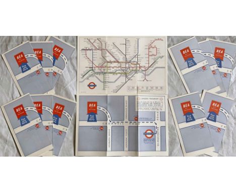
Quantity (13) of the c1965 special edition of the London Underground diagrammatic POCKET MAP, a paper version of the Garbutt design produced for distribution to arriving passengers at the British European Airways (BEA) West London Air Terminal in Cromwell Road with walking directions to Gloucester Road station. These copies have never been used and originated from LT stores. Excellent to mint condition, one or two may have minor storage marks. [13]
Lot 331
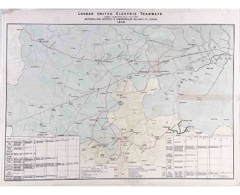
1906 POSTER MAP of the London United Electric Tramways 'showing connections with allied lines, Metropolitan District & Underground Railways of London'. Shows the company's lines plus authorised extensions, depôts, central power station etc as well as connecting LCC Tramways, Harrow Road Tramway and County of Middlesex Light Railways. Has a colour-coded index of the Underground and two panels listing lines, fares and distances. A most unusual survivor. Measures 40.5" x 30" (103cm x 76cm), mounted on card and in good condition, one short repair with archive tape. [1]

Lot 64
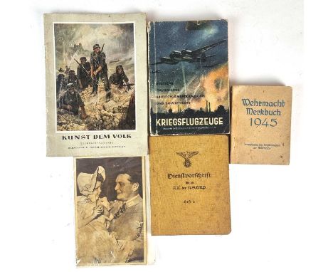
Two V.B. (Völkischer Beobachter) Strassenkarte (Road Maps), comprising map number 24 from the Osnabrück region and a map showing the whole of Deutschland, 1:200.000 scale; together with a copy of DDAC Durchfahrtsplane Fur 150 Deutsche Stadte, with several pull-out maps; and a small group of German booklets, comprising: 'Dienstvorschrift für die S.A. der N.S.D.A.P, Heft 2' (Issue 2, The S.A Economy and S.A Correspondence). In original linen bindings, dated 1932, comprising 207 pages with some illustrations; 'Wehrmacht Merkbuch 1945' (Soldier's pocket book); 'Kriegsflugzeuge' (Identification of German, Italian, British and American warplanes, 1943 edition); 'Kunst dem Volk' (Art of the Nation, 1942) together with a photographic postcard of Goering, a DAF membership book and twelve further re-print German Third Reich photographs.
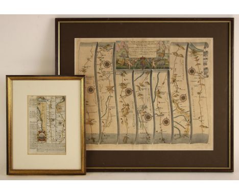
Lot 334
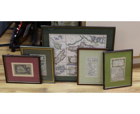
After John Ogilby (1600-1676), THE ROAD FROM WELSHPOOL COM MONTGOMERY TO CARNARVON IN NORTH WALES, a strip road map on paper, second edition, later hand coloured, visible plate mark, the plate 34cm x 42.5cm, framed and glazed, text from the first edition applied verso; with an Owen Bowen strip map on laid paper showing roads from Anglesey to North Wales and Chester, 18.5cm x 12cm, in double-sided glazed frame (2)
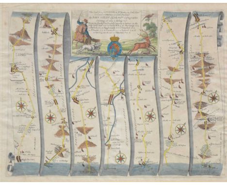
Lot 348
John Ogilby, Road from London to St Neots .. continued to Oakeham, 36x47cm; Emmanuel Bowen, Road from Hereford to Leicester, including a small map of Leicestershire; Emmanuel Bowen, The Road from London to Norwich, incorporating a small map of Rutlandshire; and a distances chart from Jacob Van Langeren, (4).
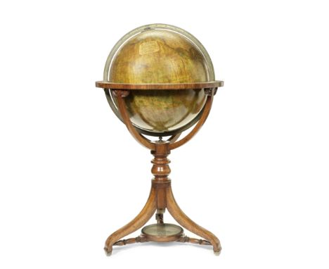
Lot 617
A Thomas Malby & Son 18-inch Terrestrial Library Globe, English, Second half 19th century,the cartouche printed MALBY'S TERRESTRIAL GLOBE Compiled from the latest AND MOST AUTHENTIC SOURCES, INCLUDING ALL THE RECENT Geographical Discoveries Manufactured and Published under the superintendence of the SOCIETY FOR THE DIFFUSION OF USEFUL KNOWLEDGE BY MALBY & SONS GLOBE & MAP SELLERS TO THE ADMIRALTY, the terrestrial globe mounted in brass meridian within horizon ring applied with printed zodiac and calendar scales, supported on three curved mahogany legs, with stretcher compass, without casters, globe 18in (46cm) diameter40in (101.5cm) high overall Footnotes:Thomas Malby's map & globe firm continued under the stewardship of his son from 1851, who was was still recorded as operating in business in 1884. Thomas Malby closely linked himself with the Society for the Diffusion of Useful Knowledge, as a way of marketing his products to the rising middle class of Britain.This lot is subject to the following lot symbols: TPTP For auctions held in Scotland: Lots will be moved to an offsite storage location (Constantine, Constantine House, North Caldeen Road, Coatbridge ML5 4EF, Scotland, UK) and will only be available for collection from this location at the date stated in the catalogue. Please refer to the catalogue for further information.For all other auctions: Lots will be moved to an offsite storage location (Cadogan Tate, Auction House Services, 241 Acton Lane, London NW10 7NP, UK) and will only be available for collection from this location at the date stated in the catalogue. Please note transfer and storage charges will apply to any lots not collected after 14 calendar days from the auction date.For further information on this lot please visit Bonhams.com
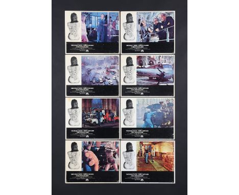
Lot 164
THE ITALIAN JOB (1969) - Set of Eight US Lobby Cards, 1969Bidding for this lot will end on Thursday 8th February. The auction will begin at 2:00PM GMT and lots are sold sequentially via live auctioneer; tune in to the live streaming broadcast on auction day to follow the pace. A full set of eight US Lobby Cards for the Michael Caine 1969 crime caper The Italian Job (1969). Each card shows a scene from the film with the heist road map of Turin drawn on the model's back; this image is derived from the American poster campaign. Rarely offered as a complete set as the more popular cards - Caine with Sir Noel Coward in prison, Caine reaching for the bullion, and the red, white and blue minis - are often removed and sold separately.(Each Lobby Card): 14" x 11" (36 x 28 cm)Additional Information: NSS #69/290Condition: Very GoodAll cards have some degree of handling wear with multiple pinholes in each corner. Some have tape residue.Artist: Unknown Artist£200 - 400VAT Status: MClick here for our Poster Auction Grading Guide
Lot 718
FOUR VARIOUS ENGRAVED MAPS, COMPRISING A ROBERT MORDEN OF OXFORDSHIRE AND ANOTHER OF WORCESTERSHIRE, A JOHN OGILBY COACHING MAP OF THE ROAD FROM OXFORD TO SALISBURY CONTINUED TO POOLE, AND ANOTHER SMALLER OF BUCKINGHAMSHIRE, SIZES VARY, TOGETHER WITH A JOHN SPEEDE MAP OF MONTGOMERYSHIRE AND A CHART OF THE WORLD DATED 1801 (THE LAST TWO UNMOUNTED AND UNFRAMED. (6)
Lot 12
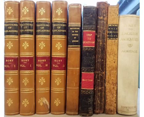
Roby (John). Traditions of Lancashire, 4 volumes, 2nd series, 2nd edition, London: Longman, Rees, Orme, Brown, and Green, 1830 - 31, additional decorative etched titles to volumes 1 & 2, 22 engraved and etched plates with skilful later hand-colouring, several marginal closed tears and slight spotting, title page to volume one with long repaired closed tear, contemporary gilt tree calf, re-backed with gilt decorated spines, worn at extremities, 8vo, together with [Cromwell, Thomas]. Excursions in the County of Surrey, 1st edition, 1821, additional decorative engraved title, folding map of Surrey, 46 engraved plates and a folding lithographic plan of Guildford, slight spotting, later half calf gilt over marbled boards, 8vo, plus Hutton (W.). A Trip to Coatham, A Watering Place in the North Extremity of Yorkshire, John Nichols and Son and others, 1810, engraved portrait frontispiece, preface, folding engraved map of Cleveland with contemporary outline colouring, index bound at rear, some spotting and offsetting, near-contemporary manuscript annotations to the recto and verso of the third front blank, 19th century half calf gilt, worn and rubbed, 8vo, plus Armitage (Ella S.). A Key to English Antiquities with Special Reference to the Sheffield and Rotherham District, published Sheffield by William Townsend, 1897, photolithographic frontispiece, numerous wood engravings throughout, contemporary ownership signature to the front endpaper, all edges gilt, contemporary vellum gilt, 8vo, and Moffatt (Rev. J. M. of Malmesbury). The History of the Town of Malmesbury and its Ancient Abbet, published in Tetbury and printed by J. G. Goodwyn, 1805, additional half-title with later manuscript ownership signatures, engraved topographical frontispiece, list of subscribers, three engraved plates and a folding table, appendix and errata bound at rear, page 229 torn with slight loss, joints cracked, contemporary half calf, heavily worn, bumped and frayed, 8vo, with Warner (Revd. Richard of Bath). A Walk through Wales in August 1797, printed in Bath by R. Cruttwell and Sold by C. Dilly, London, 1798, uncoloured sepia aquatint frontispiece, an advertisement with errata printed to verso, wood-engraved road maps as chapter headings, itinerary at rear, later ownership signature to front pastedown, hinges and joints cracked and worn with upper board near detached, contemporary half sheep with contrasting morocco gilt label to spine, worn and frayed, 8voQTY: (9)
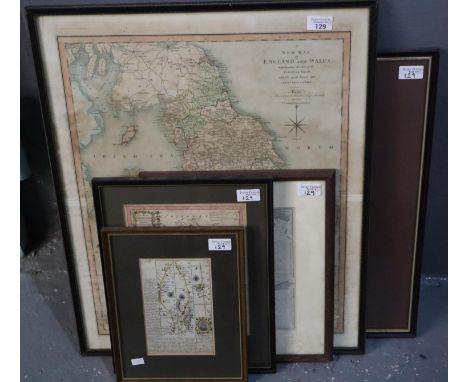
Lot 129
C Smith, 'A New Map of England and Wales, comprehending the whole of the Turnpike roads with the great rivers and navigable canals'. Originally printed 1804 second edition corrected to 1808 (58x47cm approx), together with Thomas Kitchen, a 'New Map of Shropshire'(25.5x20.5cm approx). And a strip road map of Ludlow and Shrewsbury in the Deanery of Chester pages 145 and 146 double sided (19x12cm approx). Together with Thomas Kitchen, 'Africa', original uncoloured map engraved by G Terry for John Harrison, dated 1787. 34x39cm approx. Framed. Together with a 19th century map of Sweden and Norway engraved by S Hall. 25x19cm approx. Framed and glazed. (5) (B.P. 21% + VAT)


Lot 194
Local Interest. Auctioneers: Messrs. T. Neale & Son, Nottingham. Wollaton Park, Particulars and Condition of Sale, 3rd & 4th November, 1925, [16]pp, b/w plate of the house, large format map of the freehold estate by T. Wallis Gordon, 81 x 209.5cm, folding Plans 1-3 loosely-inserted in recto sleeve, original wrappers, folio (34.5 x 21cm), with Auctioneers: Messrs. Thurgood, Martin & Eve, London. Part III: Portions of the Estates of The Right Honourable Lord Middleton. The Wollaton Estate, 2 parts, 23rd & 24th March, 1925, split, folding Plans 7-10 loosely-inserted in recto sleeve, original wrappers, tatty and soiled, fragmentary recto cover, folio (41 x 25cm), Auctioneers: Hallam, Brackett & Co., Nos. 7-13 Long Row, Nottingham, including the famous Black Boy Hotel and four shops, 25th January, 1961, folding plan, original wrappers, upper-cover with tipped-on b/w illustration, oblong 4to, a b/w photograph of Hucknall Road/Perry Road, n.d. [c. 1930], 22.5 x 29.5cm, mounted, etc

Lot 475
John Overton (1640-1713) - A new mpp (sic) of ye Rodes of England, Showing the Townes (sic) you pass through with the reputed distance between Town & Town; road map, [London]: Printed & Sold by John Overton at the White Horse Against S:e Sepulchers Church, n.d. [c.1685], etching and engraving, 52 x 46cm, with five unassociated letterpress distance charts/tables, (6)
Lot 485
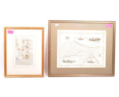
William Kip (act. 1588-1635) after John Norden (1546-1625) - Hertfordshire, double-page county map, numbered 16 within the plate, s.l., n.d. [first-half 17th c], 29 x 36cm, Nicolas Sanson (1600-1667) - Anatolia, s.l. [Paris?], n.d. [17th c], engraving, some contemporary hand-colouring, 19.5 x 25cm, an Owen & Bowen road map, c. 1720, and an 18th c French map of ancient Greece, (4) Good condition. Unexamined out of frames.
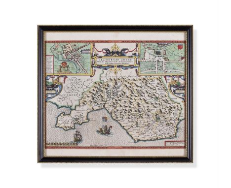
Lot 77
A GROUP OF THREE MAPS INCLUDING: A John Speede map of Glamorganshyre (sic), published John Sudbury and George Humbell, framed and glazed, 49cm x 55cm overall; Together with two strip maps by John Ogilby of the Road from St. Davids to Holywell and Carmarthen to Aberistwith (sic), 40.5cm x 50.5cm and 38cm x 49.5cm overall
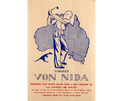
Lot 276
Original vintage sport poster for a golfing event at the Island Club in Singapore: "Exhibition Golf Match Island Club 6 1/2 Mile Thomson Road 3pm Saturday 29th January. Von Nida will play an 18 hole Exhibition Match with Jack Hodgkinson (Island Club Singapore) followed by a short demonstration of various golf shots." Great design in blue and white featuring the notable Australian golfer Norman Von Nida (Norman Guy Von Nida; 1914-2007) in a swing stance with his club raised ready to strike a golf ball with a kangaroo on the left and a map of Australia in the background, the text below in stylised blue and red letters. The Golf Club was opened in Singapore in 1891 (now the Singapore Island Country Club); Jack Hodgkinson joined the Club in 1937 and retired as Club Secretary in 1959. Good condition, staining, creases and folds in margins. Country:Singapore. Year:1949. Designer:Theo. Size (cm):56x38
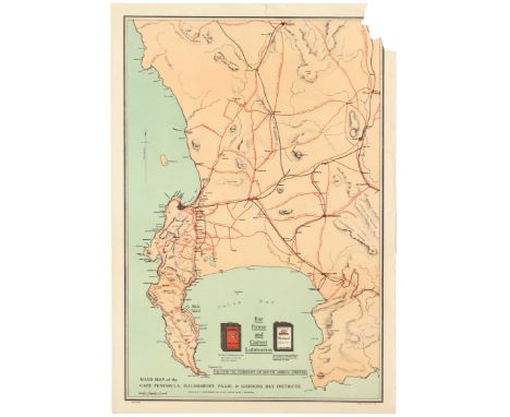
Lot 210
Original vintage Road map of the Cape Peninsula, Malmesbury, Paarl & Gordons Bay Districts. Drawn by A.I Bannerman from the best available sources of information. Presented by the Vacuum oil company of South Africa Limited. Adverts for Pegasus motor spirit and Mobiloil. Fair condition, tears, creasing. Vacuum Oil Company was an American oil company known for its Gargoyle 600-W Steam Cylinder Oil. Vacuum Oil merged with the Standard Oil Co of New York, commonly known as Socony Oil to form Socony-Vacuum Oil Company, and is now a part of ExxonMobil. County: South Africa, year of printing:1920s, designer: A I Bannerman, size (cm): 70x49. Poor condition,tears and loss on margins.


Lot 267
John Speede, 'Breknoke', an original later coloured map, Framed and glazed, together with John Bleau, 'Glamorganensis', sparsely coloured and double sided glazed frame, together with a strip road map 'Margam and Cowbridge to Haverfordwest' and a later map of South Wales. (4) (B.P. 21% + VAT)

Lot 2925
Topography, Derby & Derbyshire – Keys (John), ed. Gadd (George Frederick), Sketches of Old Derby & Neighbourhood, Derby & London, Bemrose & Sons, 1895 4to 203pp 2 plates and a folding map of the town after John Speed (1610), likewise a foldout re-drawn east prospect of Derby by Bemrose 1863 after S & N Buck, 50 engravings by Orlando Jewitt and P(ercy) C(urrey) also engraved elevation of the 1841 Guildhall after Henry Duesbury facing p. 186, inscribed ‘Mrs Ward from J & F. H. Ward, Aug. 29th 1895’, original boards, green boards and printed paper outer cover; Robinson (J. B.), Derbyshire Gatherings, A Fund of Delight for the Antiquary, the Topographer, the Biographer and the General Reader, Derby, Bemrose & London, J. R. Smith, 1866, large 4to, 106 pp, numerous slightly gauche but charming engravings by the author, bound original Gothic gilt bevelled & embossed boards (2) ** Joseph Barlow Robinson (1821-1883) was a sculptor of national standing with his workshop on Derwent Street, Derby and home in Uttoxeter New Road there. After a family apprenticeship he worked extensively on the Palace of Westminster, and later locally, notably with architect Henry Isaac Stevens, carrying out country house and church commissions throughout the Midlands and beyond

Lot 455
Small range of early 20th Century foldout Ordnance Survey / Road maps to include; Ordnance Survey Contoured Map of Bournemouth and Swanage, Ordnance Survey England & Wales – Sheet 106 [Forster Groom & Co Ltd], Ordnance Survey Tourist Map New Forest, Ordnance Survey Contoured Road Map of Truro, Cycling & County Maps – 2” Salisbury Plain [Forster Groom & Co Ltd], Touring Atlas of the British Isles – Specially Prepared for Cyclists, Motorists & Travellers [Ward, Lock & Co, London, 1909] & Phillips’ Cyclists Map of North Wales [The London Geographical Institute]. (7)
![[MISCELLANEOUS] Eighteen assorted works, in nineteen volumes, including Mothersole, Jessie. The Isles of Scilly, reprint, Re](https://cdn.globalauctionplatform.com/3313c7d3-7e5f-48ee-8b1f-b0d101040be6/d78f1562-0441-4dd0-b078-b0df00ccc0a0/468x382.jpg)
Lot 120
[MISCELLANEOUS] Eighteen assorted works, in nineteen volumes, including Mothersole, Jessie. The Isles of Scilly, reprint, Religious Tract Society, London, 1919, original blue cloth, twenty-six colour plate illustrations (including frontispiece, as called for), map, square octavo; Powell, Commander J.W. Damer. Bristol Privateers and Ships of War, first edition, Arrowsmith, Bristol, 1930, original crimson cloth, plate illustrations, quarto (front free endpaper with hole to centre); and Malet, Captain. Annals of the Road, or Notes on Mail and Stage Coaching in Great Britain, Longmans, Green & Co., London, 1876, original pictorial crimson cloth gilt (rebacked), ten colour plate illustrations (including frontispiece) and three woodcuts (all as called for), octavo.


Lot 262
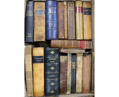
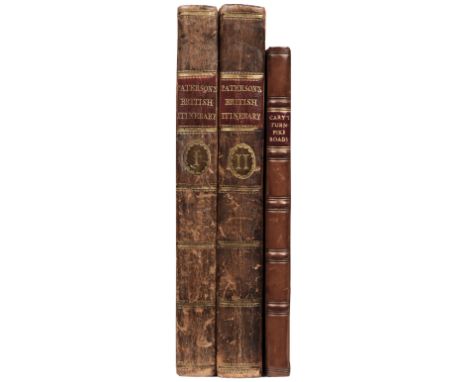
° ° Paterson's Roads...18th edition....(with) an entirely new set of maps, by Edward Mogg. folded general map (on linen) and 8 others (folded), newly rebound red half calf and marbled boards, gilt decorated and panelled spine, thick 8vo. (1829); A Collection of the Acts of Parliament....for Regulating the Turnpike Roads in England. old boards with printed spine label, uncut. 1829; with other road books and associated material (20)
Lot 815
Robert Morden (1650-1703), hand coloured map, The smaller islands in the British Ocean, sold by Abel Swale, Awnsham and John Churchill, 37 x 42cm, The Road from London to Southampton, the Smaller Islands of the British Ocean, first published, John Owen and Emanuel Bowen together with a similar example of Northumberland and a plate from Patersons Itinerary, one with text verso, largest 19 x 12cm and Petrus Bertius (1565-1629), miniature hand coloured map, Borneo Insula, 9.5 x 14.5cm
Lot 38
Paterson (Daniel). Paterson's British Itinerary being a new and accurate Delineation and Description of the Direct and Principal Cross Roads of Great Britain, 2 volumes, London: Printed and sold by Carington Bowles, 1785, double-page engraved map frontispiece to volume 1 of England & Wales with contemporary hand colouring, engraved calligraphic titles and dedication leaf, 180 engraved strip road maps printed two to a page and back to back, contemporary marbled calf gilt with contrasting morocco labels to spines, 8vo, together with:Cary (John). Cary's Traveller's Companion, or, A Delineation of the Turnpike Roads of England and Wales..., London: John Cary, 1806, 43 engraved maps with outline hand-colour including folding map of Yorkshire (lined to verso), upper blank margin of map of Derbyshire with small burn hole, modern calf, small 8vo, QTY: (3)

Lot 120
* Ogilby (John). The Road from London to the City of Bristol..., circa 1676, uncoloured engraved strip road map, slight spotting, 335 x 465 mm, retaining the contemporary sheet of explanatory text, mounted, framed and glazed, together with The Roads from Chelmsford in Essex to St. Edmonds Bury in Suffolk & Saffron Walden in Essex, circa 1676, hand-coloured engraved strip road map, large margins, 335 x 435 mm, framed and glazed, with another twenty-two strip road maps, including examples by or after Sayer & Bennett, Owen & Bowen, Gardner, Cary, Mogg, Paterson, Laurie & Whittle, various sizes and condition, sixteen framed and glazedQTY: (24)NOTE:The first described map is sheet number 10, which commences in London and passes through Brentford, Hounslow, Maidenhead, Reading, Thatcham, Newbury, Hungerford and Marlborough.
Lot 719
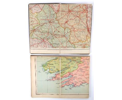
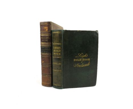
Guides: Wright (G.N.) A Guide to the Giants Causeway, 12mo Lond. 1823; with A Guide to the County of Wicklow, 12mo Lond. 1822; and A Guide to the Lakes of Killarney, 12mo Lond. 1822, 3 engd. frontis., 1 fold. map only, & 10 engd. views & 1 engd. map, cont. calf, mor. labels; & Leigh's Road Book of Ireland, 16mo Lond. 1827,lg.fold.map of Ireland, sm. fold. map & a fold. plan, orig. full mor. Both clean copies. (3)


Lot 394
Automobilia: two cased sets of Bartholomews road maps - 1920s-30s, comprising a cased set of 37 'England & Wales' maps (lacks no.13) and a cased set of 29 'Scotland' maps, both in mid-brown leather cases with plated locks, the England & Wales case with map measurer inside the lid, both with key.
Lot 498
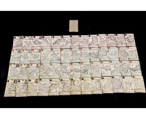
A very rare Robert Morden Miniature Map Playing Cards probably circa 1676, complete set of fifty-two cards with Explanation card, each featuring a county of Great Britain, the King features a roundel of Charles II, the Queens, Catherine of Braganza and various males as Jacks, hand-coloured, square corners, gilt edges, held in purpose made conservator’s box —3 3/4in. (9.5cm.) height of cards (eight of clubs slightly larger and not coloured, from a later edition) - this set is believed to be a first or early edition as adjacent counties not named, some of the first maps to show main road
Lot 877
Cartography Interest - A 17th century road map together with 19th century Indian map. To include an Owen and Bowen road map of South West England to include Tiverton, Minhead (Minehead) Dartmouth. With annotation of the local conveniences eg. ' Newton Bushel - Has a good Mt on Wednesday for corn, cattle & co'. Double sided. Measures 26cm x 33cm. Together with a map to depict 'Northern India: Including the Presidency of Calcutta', illustrations by A. H. Wray & Engraved by J. H. Kernot. Measures 46cm x 38cm.
-
3964 item(s)/page