We found 3964 price guide item(s) matching your search
There are 3964 lots that match your search criteria. Subscribe now to get instant access to the full price guide service.
Click here to subscribe- List
- Grid
-
3964 item(s)/page

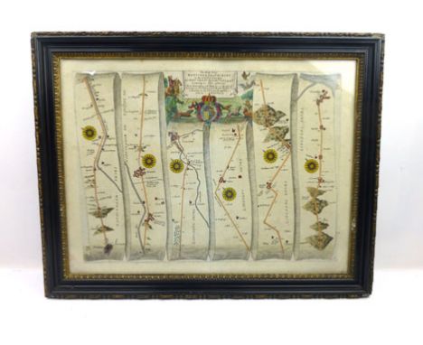
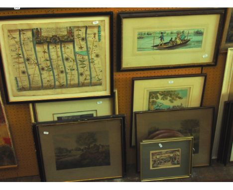
Lot 277
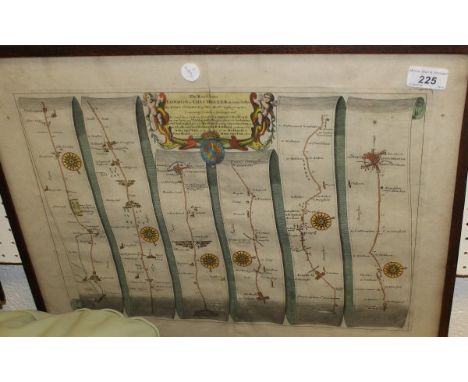
Senex (John). The Roads through England delineated or Ogilby's Survey, revised, improved and reduced to a size portable for the pocket..., published John Bowles and Son, 1762, calligraphic title, eight pages of index, text and tables, engraved map of England & Wales and 101 (complete) uncoloured engraved strip road maps printed back to back, slight offsetting, endpapers toned, front endpaper with closed marginal tears, early 20th century ink ownership stamp to verso of upper cover, contemporary limp sheep, frayed at extremities, oblong 8vo First published in 1719 this appears to be the same as the 1757 edition - Chubb CXL - but is not recorded as a separate edition in Chubb. (1)
Lot 372
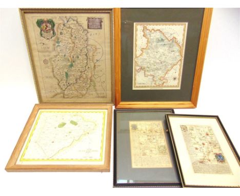
Morden (Robert). The County of Monmouth, Herefordshire, Episcopatus Dunelmensis vulgo The Bishoprick of Durham [and] Bedfordshire, [1695 or later], three uncoloured and one coloured (Herefordshire) engraved maps, each approximately 360 x 420 mm, together with Owen (John & Bowen Emanuel),A Map of Somersetshire [and] Glocestershire, [1720 or later],two hand coloured engraved maps, each with an uncoloured strip road map on verso, each approximately 185 x 120 mm, with Darton (William), Worcestershire, [1820], engraved map with contemporary outline colouring, 110 x 70 mm, with a further thirteen engraved county maps, including examples by Seller/Grose, Moule and Cary, various sizes and condition (20)
Lot 383
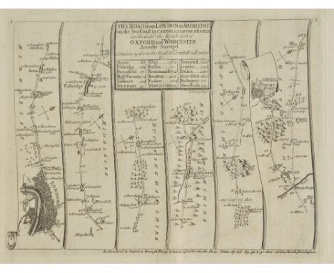
*Ogilby (John). The Road from London to Aberistwith on the Sea Coast com. Cardigan. Wherein are Included the Roads to Oxford and Worcester actually Surveyed and Delineated, circa 1676, hand coloured engraved strip road map (map no.1 in the atlas), ornate cartouche showing a surveyor using a waywiser, slight creasing, small repaired hole to image, 315 x 440 mm, mounted, framed and glazed The road runs from London through Acton, Uxbridge, Beaconsfield, High Wycombe, Oxford and Islip. (1)
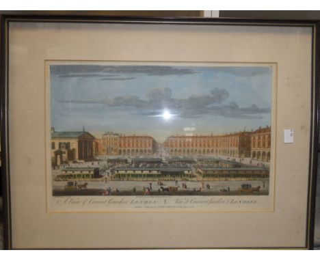
Lot 2
Thomas Bowles (1712-1767) 'A View of Covent Garden', hand-coloured engraving, pub. 12th May 1794 by Laurie & Whittle, 26 x 40 cm; 'View of New Bridge Street, Black Friars with the Albion Fire Office & c.', hand-coloured engraving, pub. 22nd Feb 1810 by Laurie & Whittle, 30 x 45 cm, some foxing to mount, James Moxon, Milford-Haven, hand-coloured engraved map, framed, 50 x 61.5 cm, some staining; The Road from Chester to Cardiff, hand-coloured engraved road map, 34 x 45 cm, (stained and discoloured) (4)
Lot 377
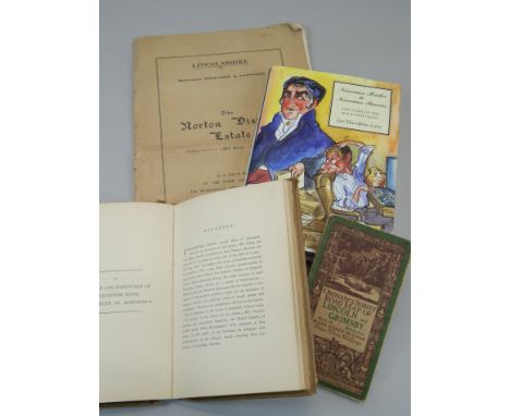
Various books, to include an auction catalogue for the sale of the Norton Disney estate, a copy of Nouveau Riches to Nouveau Pauvers, written by Ian Macalpine-Leny, signed by the author, ordnance survey map of the road between Lincoln and Grimsby and a book on the parish memorials relating to Norton Disney, published 1893
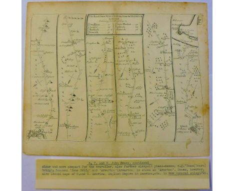
Lot 739
An 18th century coloured engraved road map showing the roads from London to Wells in Norfolk and St Edmons Bury in Suffolk by John Ogilby, 39 x 48 cm approx together with a collection of late 18th and 19th century engravings, caricature subjects, etc including a scene with elegant ladies and gentlemen in a fishing punt, a further pair of fishing engravings after J Pollard - Live-Bait Fishing for Jack and Fly Fishing for Trout, 37 x 44 cm approx, a caricature showing Light Infantry Volunteers on a march, etc together with a late 19th century monochrome study of fruit with blind embossed stamp ESK, various sizes, all framed
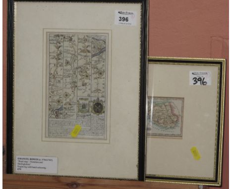
Lot 317
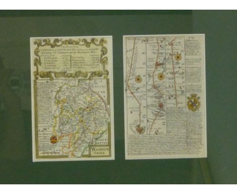
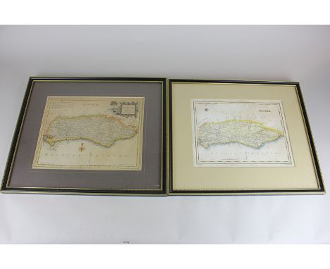
RICHARD BLOME (c.1635-1705) 'Nottinghamshire with its Wapontake',engraved county map, hand-coloured in outline, 35cm x 30cm; together with strip maps of the road from Hatherly to Camelford and King's Lynn to Thetford, by Emanuel Bowen (c.1694-1767); and county maps of Huntingdonshire and Rutlandshire, each framed and glazed, (5).
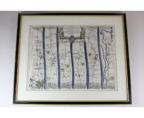
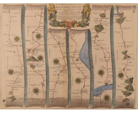
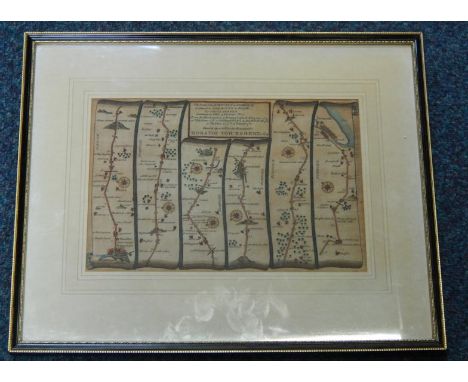
Lot 206
After John Ogilby, late 17th century strip map of The Continuation of ye Extended Road from Barnstable to Truro from the "Britannia" by John Ogilby, published in 1675 with later hand colouring . This map is Number 34 of 100 maps in the atlas and is entitled "The Continuation of ye Extended Road from Barnstable to Truro." From Hatherley to Ivy to Newport to Hall Drunkard to Cambleford to St. Indullion to Padstow to St. Colom to St. Michaell to Truro 35.5cm x 45.5cm, framed and glazed; together with a Robert Morden (fl. 1668 - 1703) Cornwall Map, possibly first edition c.1695 from Camden's Britannia, features a 'A Table of ye Explanation of ye figures in ye Map' and a further key with the note 'Here Note ye in all ye Maps Thefe Marks Signifie' and a list of symbols representing, towns villages, castles etc. 36.5cm x 43.5cm, framed and glazed (2) The Morden map trimmed to the plate marks and laid down
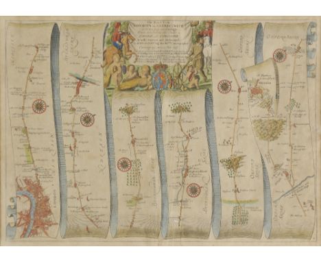
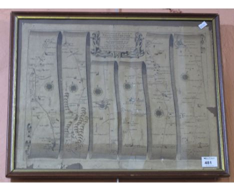
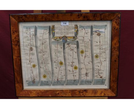
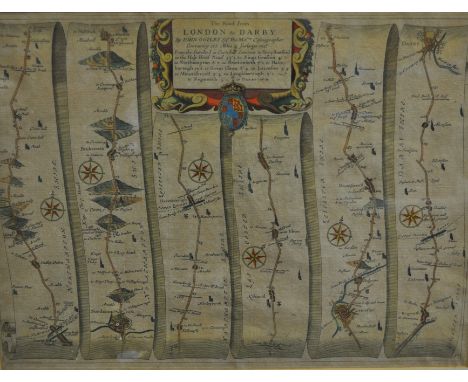
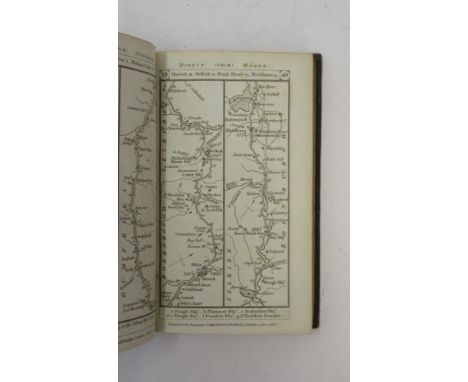
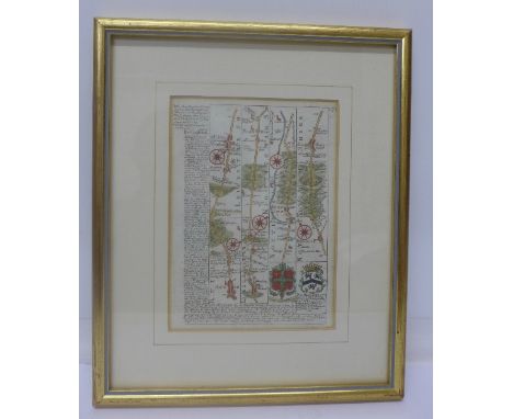
![After John Ogilby (1600-1676),
'The Road from Oxford to Coventry continued to Darby' [sic] strip map,
uncoloured engraving,
4](https://cdn.globalauctionplatform.com/27968ad9-d5dc-49a6-aeed-a60f01079d4b/4fc9789e-7983-43f7-bb66-a21a7ab1a031/468x382.jpg)
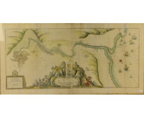
Lot 315
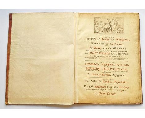
ROCQUE, JOHN An Exact Survey of the Cities of London and Westminster, The Borough of Southwark, with The Country near Ten Miles round; Begun in 1741, finished in 1745, and publish`d in 1746, according to Act of Parliament By John Rocque Land Surveyor; Engraved by RICHARD PARR, and Printed by W> PRATT; Sold by the Proprietor John Rocque, next the Duke of Grafton's Head, in Hyde Park Road, the Bottom of Piccadilly, and at the Print Shops in London and Westminster, Price Two Guineas in Sheets; then in Latin and French; A List of the Subscribers of This Work, Index of the Towns, Villages etc Compiled Within This Survey;Folio, bound engraved map on 16 double page sheets, emblematic group in cartouche at upper border surmounted by arms of the City of London, dedication to The Right Honourable Richard Boyle Earl of Burlington & Cork Viscount Dungarvon , a few very minor marginal nicks and tears to a couple of sheets, light variable browning and offsetting, minor water staining to lower corners sheets 7 & 8, slight damage to corners of folio cover; Rocque's famous map includes several of the new features he introduced to English cartography. The hilly ground behind the Royal Hospital [Greenwich, sheet II] ... shows to dramatic effect in his technique of hachure, while most of his land-use symbols are included -- marsh, market garden, orchard, ploughland, park and common' (Glanville). Glanville 28; Howgego 94 (2). Full set of images available upon request.
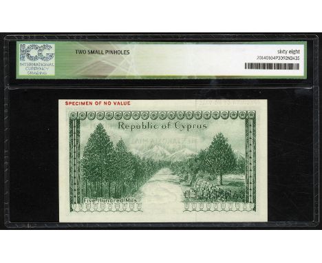
Lot 273
Cyprus, P 38s, Linzmayer B202as, Republic of Cyprus, 500 Mils, 1 December 1961, SPECIMEN. Coat of arms of Cyprus at right, map of Cyprus at lower right. Horizontal red overprint SPECIMEN OF NO VALUE in upper left margin on front and back. Diagonal purple handstamp CANCELLED on front. Mountain road lined with trees on back. Perforated CANCELLED., # A/1 000000., ICG 68, Gem UNC, two small pinholes
Lot 3544
Miscellaneous Reference and Topography - The Treble Almanack for the Year 1820, Containing I. John Watfon Stewarts Almanack, II. The Englifh Court Regiftry, III. Wilfons Dublin Directory with a New correct Plan of the City (sic), Forming The most Complete Lists published of the Present Civil, Military and Naval Establishments of Great Britain and Ireland, Printed by Authority [John Watson], Dublin 1820, 215 + 223 + 216pp + Historical Annals of The City of Dublin [xii], full period red morocco, 12mo; Paterson (Daniel), A New and Accurate Description of All The Direct and Principal Cross Road in England and Wales, eleventh edition, T.N. Longman, London 1796, xxxv + 406pp, the front with engraved two-page map of England and Wales, inserted clippings, 20th century buckram binding, 12mo; Jones' Views of the Seats, Mansions, Castles, &c., of Noblemen and Gentlemen in England, Wales, Scotland and Ireland, And Other Picturesque Scenery [...], Jones & Co., London 1829, bound as one, period half-leather and marbled boards, 4to (3)
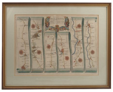
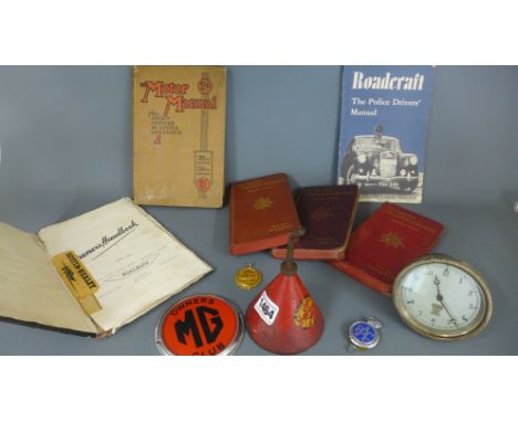
Lot 146
*Ogilby (John). The Road from Bristol to Worcester, circa 1678, hand coloured engraved strip road map, toned overall, 315 x 450 mm, framed and glazed, together with Morden (Robert), The Kingdom of Ireland [1695 or later], uncoloured engraved map, 420 x 350 mm, framed and glazed (glass cracked), with Van den Keere (Pieter), Oxfordshire, Chester [and] Shropshire, circa 1637, three hand coloured engraved maps, some overall toning, each approximately 85 x 120 mm, mounted, framed and glazed, with another five county maps by Kitchin, Cary, Cole & Roper, Hinton and Morden, various sizes and condition (10)
Lot 104
*Gibraltar. [Basire (Isaac)], Plan of the Town and Fortifications of Gibraltar exactly taken on the Spot in the Year 1738, for Mr Tindal's Continuation of Mr Rapin's History of England, circa 1748, hand coloured engraved plan of Gibralter, old folds, 370 x 580 mm, mounted, framed and glazed, together with De Vaugondy (Robert), Carte de la Californie et des Pays Nord-Ouest..., Carte des parties Nord et est de L'Asie..., Partie de la Carte du Capitaine Cluny..., circa 1740, three uncoloured engraved maps, each approximately 300 x 350 mm, with another five engraved maps similar, plus Gardner (Thomas), The Road from Bristol to Weymouth com Dorset, [1719], hand coloured engraved strip road map, 175 x 275 mm, mounted, framed and glazed, with another two framed and glazed maps similar, various sizes and condition (12)
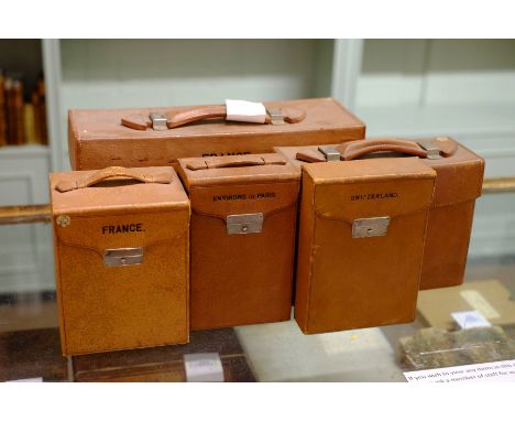
Lot 102
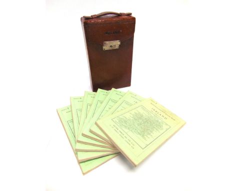
*France. Three map cases containing folding road maps, pub. Edward Stanford, n.d., c.1910, including small leather case with carrying handle with lock, stamped 'Environs de Paris', containing five (complete) colour printed folding maps, sectionalised and laid on linen. marbled end papers and publisher's label to recto, complete with measuring wheel and magnifying glass, case dimensions 195 x 125 x 75 mm, together with, another small leather case with carrying handle with lock, stamped 'France', containing four (complete) colour printed folding maps, sectionalised and laid on line, morocco gilt end papers, complete with measuring wheel, case dimensions 185 x 145 x 115 mm, plus, a larger leather case with carrying handle with two locks, stamped 'France', containing twenty-five (complete) colour printed folding maps, sectionalised and laid on linen, with four additional folding maps of the environs of Paris and a cloth bound route book, lacking measuring wheel, case dimensions 205 x 380 x 130 mm, with Italy, Map case containing twenty-four colour printed maps, pub. Edward Stanford, c.1900, leather map case with carrying handle containing twenty-four colour printed folding maps, sectionalised and laid on linen, marbled end papers, one lock (complete with key), case contains a magnifying glass (possibly not called for), case dimensions 185 x 245 x 100 mm, together with,Switzerland,Map case containing four colour printed maps, pub. Edward Stanford, c.1900, leather map case with lock, four (complete) colour printed touring maps, sectionalised and laid on linen, marbled end papers, case dimensions 200 x 140 x 50 mm (5)
![Maps - Extended Tape Indicator Map of London and Visitors Guide, C. Smith & Son, [London c.1890], original red cloth, 12mo; S](https://cdn.globalauctionplatform.com/0a4475f4-6152-4517-9e8a-a663011869ab/ceff697d-9b14-4f9f-8b10-b657a459632a/468x382.jpg)
Lot 359
PATERSON'S BRITISH ITINERARY, Being A New and Accurate Delineation and Description of the Direct and Principal Cross Roads of Great Britain, Captain Daniel Paterson, Volume II ONLY, Carington Bowles, 1785. Tree calf with gilt, engraved title page and road map itineraries printed double column
Lot 1434
PATERSON'S BRITISH ITINERARY . . . the Direct and Principal Cross Roads of Great Britain. 2nd edition improved, 2 vols. double-page general map & 87 leaves of strip road maps (in 386 numbered columns), engraved titles & explanatory letter-press; contemp. calf (distressed). Bowles & Carver, 1807.
-
3964 item(s)/page