We found 3964 price guide item(s) matching your search
There are 3964 lots that match your search criteria. Subscribe now to get instant access to the full price guide service.
Click here to subscribe- List
- Grid
-
3964 item(s)/page

Lot 264
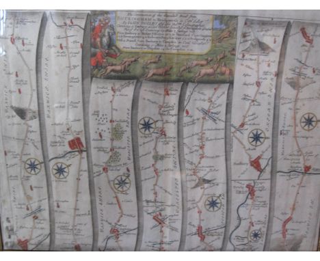
Ogilby (John). The Road from London to Montgomery North Wales, hand coloured strip road map, probably late 17th century, 44.5cm x 32cm; after Leonard Knyff, Newnham Padox (sic) Warwickshire, the seat of the Rt. Hon.ble Basill Feilding, double-page engraved bird's eye view with coat-of-arms, engraved by Johannes Kip 35cm x 48cm and Warwickshire. Saxton (Christopher & Kip, William), Warwici Comitatus a Cornauiis olim Inhabitatus, coloured and engraved map, strapwork title cartouche, separate scale of distance surmounted by dividers, 29cm x 35cm
Lot 98
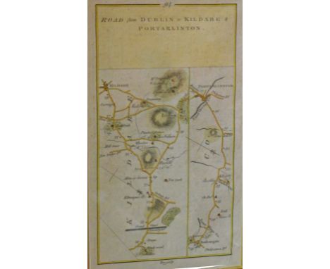
A PAIR OF ATTRACTIVE HAND COLOURED MAPS, 19th century, one showing the Road from Dublin to Kildare and Portarlington, and a further map verso, with details of the above; and another hand coloured map, uniformly framed, the Road from Limerick to Ennis, continued from Six-Mile Bridge, and verso with a map of the Road from Limerick to Galway, each 9" (23cm) x 5" (12cm). (2)
![Ogilby (John). The Roads from York to Whitby and Scarborough in Yorkshire, [1698], hand coloured engraved strip road map, dec](https://cdn.globalauctionplatform.com/602f3499-4c56-45fa-acbd-a7a900c85218/5f14ca05-ac5a-4247-b2ea-4aa4863e3e14/468x382.jpg)
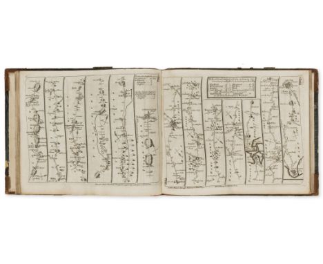
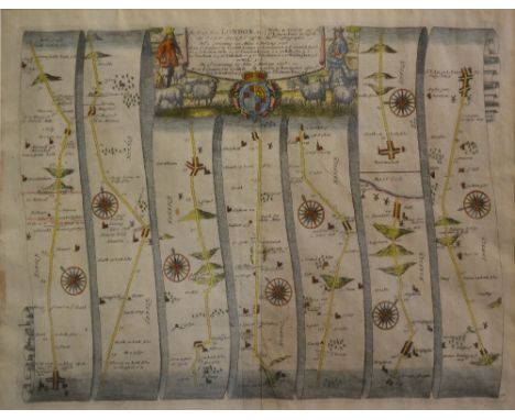
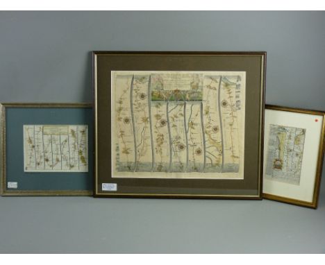
Lot 150
Ogilby (John). The Roads from York to Whitby and Scarborough in Yorkshire, [1698], hand coloured engraved strip road map, decorative cartouche showing a surveyor using a waywiser, some creasing, 330 x 450 mm The third state of John Ogilby's maps, printed by Abel Swall and Robert Morden. Sheet no. 100. (1)
![Ogilby (John). The Road from London to Dover in co. Canty, actually survey'd & Delineated, [1676 or later], hand coloured eng](https://cdn.globalauctionplatform.com/602f3499-4c56-45fa-acbd-a7a900c85218/b5544c84-1a81-4f3e-e60f-7c746b05734b/468x382.jpg)
Lot 126
Folding maps. A mixed collection of five maps, 19th century, including Cary (John), Cary's New Map of Ireland exhibiting the whole of the Turnpike roads with the Rivers and Canals; The Market and Borough Towns and principal places adjoining the Road to which is added the distance..., 1834, engraved map with contemporary outline colouring, sectionalised and laid on linen, some staining, 750 x 625 mm, marbled endpapers, contained in a contemporary marbled card slipcase with publisher's label to upper board, slight wear to extremities, together with Cary (John), A New Map of Gloucestershire divided into Hundreds exhibiting its Roads, Rivers, Parks &c., 1823, engraved map with contemporary hand colouring, some staining and soiling, 575 x 510 mm, marbled endpapers, contained in a contemporary marbled card slipcase with publisher's label to upper board, slight wear to extremities, with Walker (J. & C.), Suffolk, published Longman, Rees, Orme, Brown & Co., 1845, engraved map with contemporary outline colouring, sectionalised and laid on linen, 335 x 405 mm, contemporary cloth boards with publisher's printed label to upper siding, plus Kemp (George), Graham's New Map of England and Wales with part of Scotland showing the Mail Coach, Turnpike & Railroads, Canals &c. circa 1850, engraved map with contemporary outline colouring, sectionalised and laid on linen, slight spotting and staining, 750 x 630 mm, contemporary cloth, lacking upper board, and Ordnance Survey (publishers), Untitled map of part of Surrey, 1878, uncoloured electrotype map, sectionalised and laid on linen, the map shows Wokingham in the north-west to Croydon in the north-east, and includes Reigate, Dorking, Kingston, Chertsey and Guildford, 625 x 940 mm, marbled endpapers, contained in a contemporary red cloth slipcase with publisher's label to upper board (5)
Lot 878
A Robert Morden map engraving 'The Smaller Islands in the Indian Ocean', 17 x 22.5 cm to/w three road maps - Alresford to Salisbury via Southampton, a double-sided map Exeter to Bideford and another double-sided map, London to Poole and London & Shrewsbury, a J Rapkin steel engraved plan of Southampton circa 1850 and an Ogilby road map engraving London to Weymouth
Lot 2050
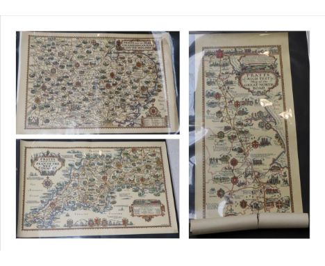
Pratts High Test A collection of six road maps by A.E. Taylor, issued by Pratts High Test, comprising; Map of the Great North Road (torn); Plan of the Roads of the South Coast; Plan of the Bath Road; Plan of the Eastern Counties and the Midlands; Plan of the West Country; Plan of the North - Moor, Mountain and Lake District (6) Buyer's premium of 20% (+VAT) applies to this lot
Lot 2024
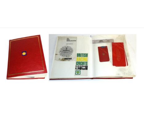
BP/Shell Interest: A Red Album, containing sixteen double-sided pages of ephemera, to include photographs, conversation guide, licence holders, calendars, road map, pictures, inter-converter, hangover pack, signed photographs, ruler, pocket book of tables, Aladdin pink enamel advertising plaque, bookmark etc Buyer's premium of 20% (+VAT) applies to this lot
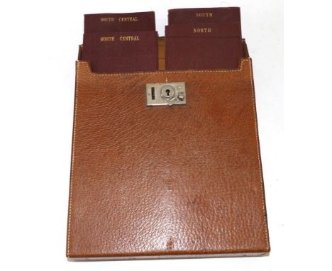
Lot 2034
Sifton Praed & Co Ltd, Map Sellers, Book Sellers and Stationers: A Set of Four Road Maps of Britain, 1920's/30's named North, South, North Central and South Central, contained within an original 1920/30 leather carrying case with hinged lid, chrome clasp, inside of lid stamped SIFTON PRAED & CO LTD, 67 ST JAMES'S STREET, SW1 See illustration Buyer's premium of 20% (+VAT) applies to this lot
Lot 380
A selection of books and ephemera, to include, FIELD SERVICE POCKET BOOK 1914, (reprinted 1917); WINTER (J), GARRISON GOSSIP, White & Co, 1887; THE DUNHILL GUIDE TO GREAT BRITAIN; CYCLING PROFILE AND ROAD BOOK OF ENGLAND, with folding map; OGDENS NEW CENTURY PHOTPGRAPH ALBUM; a Victorian Carte-de-visite album with portrait photographs, a hand drawn plan of the elevations of the public library Wrexham, a Burroughes & Watts snooker score board, five boxed 'parlor games' by Delgado, and other items (Qty)
Lot 116
England.- Ogilby (John) and John Senex. The Roads through England Delineated or, Ogilby's Survey, revised by John Senex, engraved calligraphic title, 4 letterpress leaves, engraved general map and 101 strip road maps on 51 leaves, printed on both sides, a little soiled and stained, general map shaved at upper edge, ex-subscription library copy with small ink stamp on title and first leaf of text and label on front pastedown, contemporary half russia, a little worn, rebacked preserving old spine, [Chubb CXL], oblong 8vo, John Bowles, 1757.
Lot 468
Assorted Publication Selection to include1909 Royal Visit to Birmingham University Programme, The Royal Tour of Southern Rhodesia, The RAC County Road Map & Gazetteer of England & Wales, 1931 Armchair Science, 1948 Sporting Chronicle Handicap Book, 1937 Exposition International Arts et Techniques, plus other ephemera, worth inspecting (10)
Lot 277
China Map 1793 Sketch of the Pay-Ho or White River and of the road from PEKIN to GEHO taken 1793, engraved by B. Baker, published 12th April 17965 by George Nicol, 'An Authentic Account of An Embassy from the King of Great Britain to the Emperor of China', mounted on card, perfect for framing, overall size 52 x 62cm, with minor stains, but still clear
Lot 5854
Emanuel Bowen (1694 - 1767) after John Ogilby (1600 - 1676), double-sided road map, Ipswich-Norwich-Cromer, nos. 195 and 196, hand-coloured engraving, 19cm x 12cm; a 19th century hand-coloured engraved map, of The Isle of Wight, 20.5cm x 26cm; others, various, 18th century and later, loose (qty)

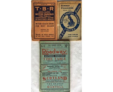
Lot 194
Selection of 1920s/30s Bus/Coach TIMETABLE BOOKLETS comprising January 1924 'TBR' (Travel by Road) Official Motor Omnibus & Charabanc Guide of England & Wales (tear to spine, fold-out map present but fold-tears), 1930 Summer Programme London Coastal Coaches 'ABC' Guide (good condition) and 1931 'Full Summer Edition' of 'The Roadway' Express Services Time Table for Great Britain (scuffed spine, otherwise good, pocket at rear is empty). [3]
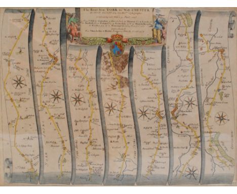
Lot 3372
A collection of five 18th century maps, copper engravings on laid/chain-lined paper, hand colured to include Warwickshire (Kitchin) Ogilby road map of York to West Chester (showing Derby, Buxton): Leicestershire (Robert Morden): Staffordshire (Roabert Morden): and another similar showing Warwickshire (inc. Coventry and Tamworth) framed and glazed (5)
Lot 129
Bowen (Emanuel & Owen John). A collection of thirty-one maps originally published in 'Britannia Depicta', [1720 or later], thirty-one uncoloured engraved county maps, strip road maps to verso, sheet size 185 x 120 mm, together with thirty-eight uncoloured strip road maps from the same series, plus eleven county maps by Seller/Grose, two copies of Moll's map of the North Riding of Yorkshire, (one coloured), a Mercator/Hondius map of Scotland and two other maps similar, various sizes and condition (86)
Lot 150
Cary (John). Cary's Traveller's Companion, or a Delineation of the Turnpike Roads of England and Wales..., 1791, calligraphic title, advertisement and contents list, forty-three (complete as list) engraved maps with contemporary outline colouring, printed back-to-back, text block detached, contemporary calf, crudely repaired with sellotape, rubbed and worn, 8vo, together with Bowen (Emanuel), A Corrected Map of the County of Stafford divided into Hundreds..., published H. Overton, J. Bowles, H. Parker, Carington Bowles, J. Ryall & R. Sayer and T. Kitchin, circa 1750, engraved map with contemporary outline colouring, sectionalised and laid on linen, 525 x 410 mm, contained in a contemporary marbled card slipcase with printed label to upper board, with another twenty-two folding county, touring and regional maps including examples by Cruchley, Hall, Bacon, J & C Walker, Philips, Bartholomew and Ordnance Survey, plus two Ordnance Survey maps of parts of Warwickshire and Staffordshire (dated 1834 & 1862 respectively), each sectionalised and laid on linen and each contained in contemporary green morocco slipcases with envelope style lids, each approximately 630 x 715 mm, plus seven guide and road books, including examples by Cary, Fraser and Blacks, various sizes and conditon Sold as a collection of maps and plates, not subject to return. (approx.35)
Lot 174
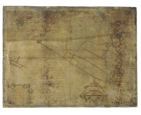
Estate Plan. A Map & Description of the Manor of Walmer lyinge in East Kente with one Tenement one Parte of Marsh and 16 Peeces of Errable & Pasture thereunto belonginge, contayninge acers 320:0:2, [surveyed by] William Boycot, 16[40?], pen, ink and watercolour on vellum, decorative strapwork cartouche, coat of arms, compass rose and distance scale, a flotilla of ten ships in the sea outside Deal Castle, one ship (heavily soiled and indistinct) outside Walmer Castle, plus a few smaller vessels in the sea, also depicting the two castles and buildings for the towns of Deal and Walmer, the coastal bulwark ('White Bullworke' and 'Blacke Bullwork'), also identifying various plots, the boundary for the Archbishop of Canterbury, the road from Deal to Dover, names of tenants and their landholdings including Edward Boys, Robert Gillo, Caleb Cocke, William Coppin, Sir Matthew Mennes and Ezekiel Parker [died 1641?], a few small holes, some soiling throughout including very heavy soiling from mildew largely occuring in two vertical strips (just east of Deal Castle and through Walmer and Walmer Castle), blue wash border with old stud holes from previous framing, rebacked on modern thick paper, 538 x 715 mm A rare Kentish estate plan from the reign of King Charles I, which in spite of its condition issues is historically revealing. William Boycot (flourished 1615-48) 'was a prolific cartographer of considerable skill with a distinctive use of blue and yellow, especially in his borders and for other decoration and also of a fine red pigment... he worked widely but mainly in the east of the county... More than twenty of his maps are known to survive and as a group they form one of the finest Kentish expressions of cartography for the years before the Interregnum' (F. Hull, 'Kentish Map-Makers of the Seventeenth Century' in Archaeologia Cantiana, volume 109 (1991), p. 70).N.B. It has been noted that the above item may contain manorial documents which are subject to the Manorial Documents Rules 1959, 1963 and 1967, administered by The Historical Manuscripts Commission at The National Archives on behalf of the Master of the Rolls. Accordingly the purchasers of the documents lie under an obligation to notify the Secretary of the Commission of their acquisition and to provide details of where they will be kept. They may in no circumstances be removed from England and Wales without the prior consent of the Master of the Rolls. (1)
Lot 192
India. Pierson (Francis, Royal Engineers, Surveyor), Sketch of Road from Baghdad to Khanuakin, 29th February 1864, manuscript pen and ink map with notes to margins and on verso, old folds, small split along old fold, 410 x 320 mm A map which trys to illustrate the feasibility of a London to India Telegraph. One of Pierson's marginalia states "The red line marks the proposed direction for the Telegraph. Note. There may be some error in the representation of the road between Bakooba & Sheraban, owing to the loss of my note book. It is however, approximately accurate. FP". (1)
Lot 230
Reference. A mixed collection of eighteen map reference books and facsimile atlases, 20th century, including Ogilby (John), Britannia volume the first..., 1675, facsimile edition, published Osprey, 1971, 100 double page strip road maps, publisher's cloth gilt, folio, together with facsimile atlases of 'Britannia Depicta' and Taylor & Skinners 'Survey of the Roads of North Britain or Scotland', with Shirley (Rodney W.), Early Printed Maps of the British Isles 1477 - 1650, revised edition 1991, [and] Printed Maps of the British Isles 1650 - 1750, published 1988, two volumes, each with numerous illustrations, dust jackets, publisher's cloth gilt, 4to, plus Manasek (F.J.), Collecting Old Maps, published Terra Nova press, 1998, numerous black and white illustrations throughout, dust jacket, publisher's cloth gilt, 4to, and Booth (John), Antique Maps of Wales, 2nd edition, 1978, numerous black and white illustrations throughout, dust jacket, publisher's cloth gilt, 4to, with Skelton (R.A.), County Atlases of the British Isles, 1579 - 1850, revised edition 1978, numerous black and white illustrations throughout, dust jacket, publisher's cloth gilt, 4to, with others similar (18)
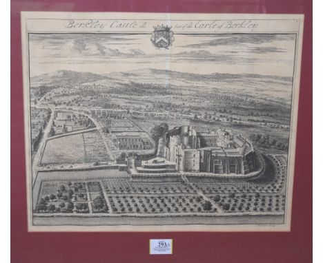
Lot 293
*Kip (Joannes). Berkley Castle the Seat of the Earle of Berkley; Alveston the seat of Edward Hill; Kingsweston the seat of Edward Southwell Esq; Boughton Court the seat of Sr. Barnham Rider Kt.; [and] Amney the Seat of Robert Pleydell Esq., circa 1720, together five engraved views, Alveston view with later hand colouring, each approximately 355 x 435mm, initial four views mounted, framed and glazed, Amney unframed, plus Gardner (Thomas), The Road from Oxford to Chichester; The Road from Tinmouth in Northumberld., to ye City of Carlisle in Cumberld., [1719], together two hand-coloured engraved strip road maps, 'The Road from Tinmouth..., with one worm hole, each approximately 185 x 270mm, mounted, framed and glazed, plus Sayer (R. & Bennett J.), The Road from Dartmouth to Minehead in Somersetshire, circa 1775, hand-coloured engraved strip road map, with 'The Road from St David's to Holywell..., printed to the verso (map on verso uncoloured), 160 x 215 mm, mounted, framed and double glazed (8)
Lot 62
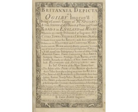
Bowen (Emmanuel). Britannia Depicta or Ogilby Improv'd being a correct coppy of Mr Ogilby's actual survey of all ye Direct & Principal cross roads in England and Wales..., 2nd edition, London printed for & sold by Tho. Bowles, Print & Map seller next ye Chapter House in St. Pauls Church-Yard & E.Bowen Engraver & Print Seller near ye stairs in St.Katherines, 1720, [1721], engraved title, four pages of tables & maps, 273 uncoloured engraved county maps and strip road maps printed back-to-back, slight staining and spotting throughout, bookplate of Sir Cedric Wolseley Bart, all edges yellow, 19th century mottled half calf with decorative gilt spine with contrasting morocco labels, slight rubbing to extremities, 8vo Chubb CXLVIII. This edition with the pagination numbers corrected on pages 121 & 124. (1)
Lot 439
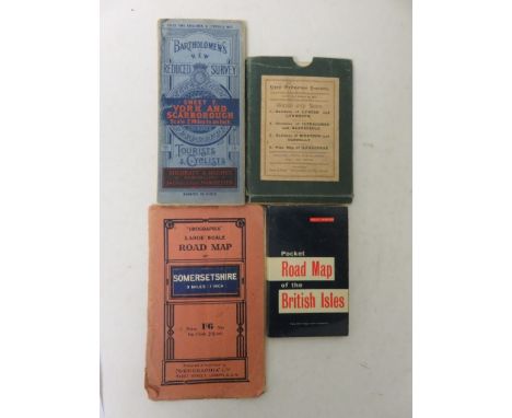
Cased set of four New Ordnance Survey maps made by Twiss and Sons showing the Environs of Lynton and Lynmouth, 24cm x 42.5cm; Environs of Ilfracome and Barnstaple, 40cm x 32.5cm; Environs of Bideford and Clovelly, 22xm x 54.5cm; and a Plan Map of Ilfracombe, 37cm x 48cm - contained in one case, tog. w. a 'Geographia' Road Map of Somersetshire, a Bartholomew's Tourist and Cyclists, Sheet 7 York and Scarborough Map, and a Pocket Road Map of the British Isles (7)
Lot 34
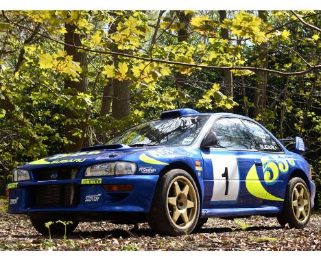
1996 Subaru Impreza WRC 97 As far as historic rally cars go, Subaru Impreza WRC97001 is one of the most important ever made' (David Lilywhite - Octane magazine, May 2010) 'To many, the mid 1990s was the heyday of the Subaru World Rally Team. Following the drivers' and manufacturers' double in 1995 and a further manufacturers' title in 1996, the blue and yellow Impreza was rapidly becoming the icon of the championship and Colin McRae one of rallying's great stars. 1997 brought in a new era in the World Rally Championship, with the introduction of the appropriately named World Rally Car formula. While some continued to compete with what were predominantly modified Group A cars, the new FIA regulations provided an opportunity to bring new manufacturers into the championship, who otherwise were unable to homologate suitable road cars. At Prodrive we seized the opportunity, and while our Group A Impreza was already very competitive, we went back to the drawing board to develop a new two door Impreza World Rally Car from scratch. The engineering team, led by David Lapworth, spent 1996 developing the new car, and by the last event of the season, Rallye Catalunya, we were able to unveil our new car to the world's press. Whilst at this very same event, Colin McRae gave the Impreza Group A a fitting send off by winning the Spanish rally and clinching a second manufacturers' title for Subaru. Chassis 001 was the car we unveiled and used as our primary test and development car. It was thanks to the many hours Colin and the other drivers spent at its wheel, that when it came to the car's debut at Rally Monte Carlo in January 1997, Piero Latti was able to claim victory and help Subaru go on and win a third consecutive manufacturers' title' (David Richards - Prodrive, 2009) Taking full advantage of the new WRC rules, Lapworth and his team liberated considerably more power and torque from the Impreza's force-fed 1994cc engine but without sacrificing reliability. Occupying almost an entire inner wing the newcomer's huge airbox was complemented by a similarly enlarged intercooler that sat in front of, rather than atop, the charismatic flat-four thus minimising heat soak. The turbocharger itself was little altered but revised inlet / exhaust systems saw outputs increase to 300bhp and 347lbft of torque. The adoption of a two- rather than four-door bodyshell brought a notable increase in torsional rigidity as did the use of CAD to optimise the form and positioning of the integral rollcage (each monocoque took over 600 hours to reinforce / prepare), while the new regulations also allowed the McPherson strut suspension to have longer travel. Less reliant on computer control than its successors, the WRC97 fed power to all four wheels via a six-speed manual gearbox and front / centre / rear differentials. Styled by Peter Stevens of McLaren F1 fame, the car's blistered wings, front / rear spoliers, side skirts and even door mirrors were all wind tunnel-honed to maximise their aerodynamic efficiency. Hailed by Colin McRae as 'quick straight out the box and generally a bit better in every way as well as faster' than its Group A predecessor, Chassis 001 paved the way for its WRC97 sister cars to claim 119 stage wins and eight out of the fourteen World Rally Championship rounds between them. The eWRC-results.com website records Chassis 001 winning the 1998 Boucles de Spa Alphonse Delettre Rally in the hands of Gregoire de Mevius / Jean-Marc Fortin before being sold to Procar of Italy. Seemingly victorious on the Rali Vinho da Madeira, Rally Cyprus and Aviano Rally in 1999 that same year apparently saw it piloted by none other than nine-time motorcycle champion Valentino Rossi to eighth place on the Rally di Monza. The Subaru's accompanying FIA World Rally Car Technical Passport reveals that it contested the 1999 Acropolis Rally and 2001 Swedish Rally but retired from both due to mechanical failure. Driven on the latter event by Tomas Hrdinka / Petr Gross under the Styllex Tuning Prosport banner, the Impreza subsequently carried the duo to a handful of victories and podium placings. Rallied extensively in Ireland from 2002 - 2007, Chassis 001 proved competitive into its final season. Initially road registered as 'P555 WRC' (and tested in Spain by McRae right after the Rallye Catalunya with that plate on) but better known by its long-term moniker 'P18 WRC', the car had been given a superficial cosmetic refurbishment prior to entering the current ownership. Drawn to 'first editions', the previous keeper not only had Prodrive validate Chassis 001 but also commissioned them to restore it to 'original' condition (becoming the Banbury outfit's first heritage customer in the process). The car was renovated using only original SRT parts, many of which would be even more difficult to source today. Overseen by Prodrive sales manager Steve Smith and documented in an accompanying hardback book, the resultant rejuvenation remains highly impressive and a real credit to David Richards and his team. Acid dipping revealed that Chassis 001 had endured a busy rally life but amazingly still retained its original Prodrive bodyshell, which was painstakingly repaired by the same team who had fabricated it in 1996! Kevin Locke rebuilt the flat-four with a new stock closed-block and internals, plus the difficult to find SRT exhaust manifolds, after which it was set-up to run on super unleaded via a revised engine management map and suitable dyno testing. Fellow Prodrive staffer Darren Pentley overhauled the complete transmission and then tested it on Prodrive's unique transmission dyno before sign-off. A suitable handover ceremony marked the project's completion on 18th December 2009. The inscription in Chassis 001's restoration book from that day simply reads: "best wishes and congratulations on acquiring a very special car - David" The vendor sums up 'P18 WRC' as follows: "It's a truly exhilarating car to drive with levels of grip and handling that would still embarrass many a modern supercar. Plus it runs on high octane pump fuel. It's doubtful that there will ever be another Subaru rally car from the same period restored like this one if only because the correct SRT parts are so difficult to locate. Pattern parts might be produced in time but Chassis 001 is the real thing" We can only echo his sentiments and invite you to buy an important part of motorsport history. A period film presented by Tiff Needell which chronicles the development of Chassis 001 can be viewed at https://www.youtube.com/watch?v=aUZ0v80nzys PLEASE NOTE: All estimates are subject to a buyer's premium of 16.2% incl. VAT (@ 20%)
Lot 87
JOHN OGILBY coloured and tinted road map, plate no. 87 - 'The Road from Welshpool to Carnarvon in North Wales', 35.5 x 43 cms with text page details verso, OWEN & BOWEN coloured and tinted road map 1720, plates 57 & 58 - 'Northop to Holyhead', 18 x 12 cms, glazed verso and JOHN SENEX coloured and tinted road map, 1719 - 'The Road from London to Montgomery', 15.5 x 21 cms

Lot 1470
5th-1st century BC.A collection of mainly iron objects forming part of a grave assemblage, comprising: a throwing spear with barbed head and spike finial, ritually bent and broken; a thrusting spearhead with narrow leaf-shaped blade, median square rib, closed socket; a horse's snaffle bit with attachments; fragments of the lateral binding strip for a scabbard, one with a suspension ring; two bronze domed fittings; iron fittings for an organic vessel including a boss and radiating lobed arms, one bent beneath the boss, two substantial rings and a spiked staple; polaroid photograph of the group in conservation (with sword); detailed archaeological drawing of the group at 1:1 scale; detailed drawing of the group's disposition prior to excavation (with sword and vessel), dated 17th October 1986 with sketch map showing the site location close to a road junction near Aguilas, Murcia, Spain. 1.6 kg total, bit: 28cm (11"). Fair condition.Property of a London gentleman; acquired from a major Mayfair gallery; acquired on the London art market before 1999.The throwing spear had been bent and broken before deposition, a common practice in many parts of Europe in the Iron Age whereby items intended for burial had to be ritually 'killed' (put beyond use").
![Lincolnshire Maps - A Large Collection including Speed, John The Countie and Citie of Lincolne described. [1610], Double-pag](https://cdn.globalauctionplatform.com/f7ecc0c4-f95b-425e-aa5a-a75201035f2b/ae3749ed-869c-4a05-faff-49ecc7aae721/468x382.jpg)
Lot 28
Lincolnshire Maps - A Large Collection including Speed, John The Countie and Citie of Lincolne described. [1610], Double-page engraved map, 2 copies, coloured and uncoloured, (coloured copy strengthened on verso with slight split, no loss), English text on verso, (414 x 536mm.); Bowen, Emmanuel. An Accurate Map of Lincolnshire.. for R. Sayer, T. & J. Bowles, 1750, (727 x 560mm.); A New Map of the County of Lincoln. London: C. Smith, 1801, (650 x 518mm.); Blaeu, Johannes Lincolnia Comitatus. Anglis Lincoln-shire. [c.1648 and 1670], 3 copies, hand-coloured double page maps, one with Dutch text on verso, one with French text on verso, one with no text on verso (641 x 528mm.); Bowen, E. An Accurate map of Lincoln Shire. Printed for T. Kitchin, hand-coloured in outline, (575 x 460mm.); Cary, J. A Map of Lincolnshire. J. Stockdale, 1805, 2 copies, (580 x 482mm.); Mordern, Robert Lincolnshire. 3 copies, (417 x 490mm.); Ogilby, John The Road from Nottingham to Grimsby, hand-coloured engraved strip map, (380 x 453mm.); Saxton, C. & W. Kip. Lincolniae Comitatus, [c.1710], uncoloured, (320 x 370mm.); Walker, J. & C. Lincolnshire. Longman [&c.], 1835, hand-coloured map, 420 x 345mm.); Kitchin, T. Lincolnshire drawn from the best Surveys & Maps, hand-coloured in outline; and 32 small later maps or road maps relating to Lincolnshire, and 11 miscellaneous later maps
![Maps, including Malby, Thomas Map of the County Palatine of Durham. [c.1859] Folding map, hand-coloured, dissected and backe](https://cdn.globalauctionplatform.com/f7ecc0c4-f95b-425e-aa5a-a75201035f2b/a62904dd-a29e-4ae0-fa27-ad103c92bb41/468x382.jpg)
Lot 29
Maps, including Malby, Thomas Map of the County Palatine of Durham. [c.1859] Folding map, hand-coloured, dissected and backed on linen, folding into cloth covers; Shadforth & Dinning. Map of the County of Northumberland. Newcastle, 1847, folding map, hand-coloured, dissected and backed on linen, morocco slipcase; another copy, 1848, folding map, hand-coloured, dissected and backed on linen, morocco slipcase (bottom detached); Bowen, Emanuel An Accurate Map of the West Riding of Yorkshire. J. Bowles, [c.1760], folding map, hand-coloured in outline, dissected and backed on linen, slipcase; Smith, C. A New Map of England and Wales. 1804, folding map, hand-coloured, dissected and backed on linen, slipcase worn; Walker, J. & C. Walker's Northern Counties, 6 folding maps, hand-coloured in outline, dissected and backed on linen, cloth slipcase; Bowles & Carver Bowles's Road Director through England and Wales. Folding map, hand-coloured, dissected and backed on linen, marbled slipcase; Cruchley, G.F. Cruchley's Travellers Companion through England and Wales. [c.1860], folding map, dissected and backed on linen; Black, A. & C. Black's Road & Railway Travelling Map of Scotland. [c.1860], folding map, coloured, dissected and backed on linen; and 1 Walker map of Middlesex (10)
Lot 241
Assorted Wedgwood collectable's and an armorial framed printsTo include Wedgwood Jasper Ware trinket boxes, Wedgwood Queens Ware bowl, Burleigh Ware George V commemorative cup, Wedgwood tapering glass paper weight, three framed armorial prints, framed map "The Road from London to Buckingham", and an 18th Century pewter plaque, qty
Lot 221
Three Catalogues. An M & A Motor Carriage Trim and Fittings for 1924, 71pp and a hard cover. Pierre Robin of Lyon, car parts, spares and fittings for 1932, French text, and a general Aviation and Automobiles loose-leaf folder illustrating instrumentation, steering, dynamos, brakes, etc., French, date unknown. Also, a 1969 reprint of a 1904 Handbook of Gasoline Automobiles, excellent illustrations. 83pp, hardbound with DJ, and a 1924 Motor Guide to the Bombay area of India, with folded coloured map and other maps, giving a guide to the road types, unmetalled roads, stations, bridges, etc. 168pp in a green binding. All in used, but sound condition (5)
Lot 1040
Postcards, a mixed age collection of approx 300 cards inc modern map cards, many comic inc Cynicus, Comicus, Tempest, McGill, Tom Browne, 'The Captain' series, Attwell, Barribal also a few UK topographical inc RP's of Wedmore Hall and Wedmore from Granville Road etc (mixed condition, fair/gd)
Lot 174
Wenyon (Charles ). Across Siberia on the Great Post-Road, 2nd edition, Charles H. Kelly, 1898, portrait frontispiece, and monochrome illustrations after photographs, folding map, original green cloth gilt, a little rubbed, together with Grenfell (Wilfred Thomason), Adrift on An Ice-Pan, 1st edition, 1910, monochrome plates after photographs, original pictorial cloth, very slightly rubbed (generally a very good copy), plus Du Chaillu (Paul B.), The Land of the Midnight Sun, new edition, 1899, monochrome wood engraved illustrations, folding map, contemporary maroon half morocco gilt, a little rubbed, and Kippis (Andrew), A Narrative of the Voyages Round the World performed by Captain James Cook, Bickers & Son, 1878, monochrome plates, some light spotting to margins, all edges gilt, contemporary gilt-decorated green cloth, very slightly rubbed (generally a good copy), plus other various travel and polar exploration, including Abruzzi, Farther North than Nansen, 1901, Lachambre & Machuron, Andr‚e and his Balloon, 1898, M. Douglas, The White North/Breaking the Record, both Thomas Nelson, 1899, J. Arthur Bain, Life and Explorations of Fridtjof Nansen, new edition, revised, circa 1900, etc., mostly late 19th/early 20th century, mostly original decorated cloth, but including some prize bindings, 8vo (38)
Lot 238
British county maps. A mixed collection of approximately fifty-five engraved maps, 18th & 19th century, including engraved county maps by Thomas Moule with seven with contemporary hand colouring, and twenty-nine strip road maps by Jeffery and Kitchin, two maps of England and Wales by Mallet and a small Robert Morden map of Durham, occasional duplicates, various sizes and condition (approx.55)
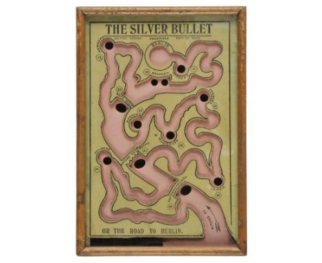
Lot 289
*Map game. The Silver Bullet or the Road to Berlin, manufactured by R.Farmer and Son, circa 1916, a British wartime dexterity puzzle in the form of a stylised map charting the Allied advance on Berlin, manufacturer's instructions printed on a label to verso of frame, 240 x 165 mm The game comprises of a small wooden glazed box in which a silver ball bearing is manipulated through a simple maze littered with military obstacles and battlefield hazards such as mined roads and destroyed bridges. The maze shows the route of the Allied advance to Berlin with cities such as Cologne, Dresden, Hanover and Potsdam along the way. If the advancing army's silver ball is lost down one of the many traps and holes it magically re-appears in the bottom left hand corner allowing the player to try again. The instructions on the verso explain the finer points of a simple but difficult game of manual dexterity. (1)
Lot 297
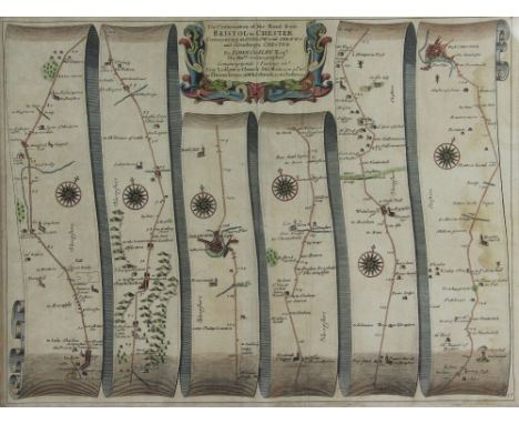
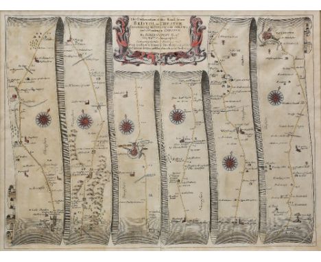
Ogilby (John). The Continuation of the Road from London to Barwick, beginning at Tuxford & extending to York (2 copies), and The Continuation of ye extended road from Barstable to Truro, circa 1680, three hand coloured engraved strip road maps, slight fraying to the margins of the 'Barstaple to Truro' map, each approximately 355 x 445 mm (3)
Lot 118
A vintage police truncheon, of plain wood design with turned handle, stamped C1106 to base of stem ,47cm long, together with an oak side table with barley twist legs, 72cm high, a Victorian clock, a box of ebony & ivory dominoes, a large oak box, a small wooden cigarette box and a vintage road map of Great Britain etc (8)
Lot 1763
A FINE COLLECTION OF ANTIQUARIAN MAPS OF CUMBRIA AND WESTMORLAND Forming an impressive cartographic record of the region c.1650-1850, by some of the most famous map makers; single sheets (often double-page), 8vo to large folio size, in generally good condition, and in most cases with contemporary or early hand colouring: Saxton (Christopher) Cumbria sive Cumberlandia, engraved by William Kip with early hand colour for Camden's Britannia [1607], Latin text to verso; Blome (Richard), A Generall Mapp of the Countie of Cumberland [&] A Mapp of the Countie of Westmorland, 1672, with a combined 'Generall Mapp' of both counties of the same period (Blome also?); Blaeu (Johannes) Westmoria Comitatus Anglice Westmorland [&] Cumbria vulgo Cumberland [c.1645 or later], both with Latin text to verso; Jansson (Jan) Cumbria & Westmoria vulgo Cumberland & Westmorland [c.1650], Dutch text to verso; Morden (Robert) Cumberland, [1695 or later], Swale and Churchill; also a stained large Westmorland published by Greenwood 1830 (eng. J. & C. Walker), plus a quantity of smaller maps from well-known 18th and 19th century publications by Cary, Kitchin, Pigot, etc. (some reduced versions/copies of earlier maps), with a map from an unidentified German atlas, plus a reproduction of Saxton's 1576 Westmorland map [with:] strip road maps from John Ogilby's Britannia (1698 edition?), some plates from the reduced Ogilby by John Owen and Emanuel Bowen [1720], with the two relevant county maps from the same volume; some road maps from later guides, some tables of travelling distances, often with armorial embellishments and a Map of the Black Lead Mines, 1751, for the Gentleman's Magazine Lot includes four British Isles maps, including Hole (William) Englalond Anglia Anglo Saxonum Heptarchia, [c.1637], early hand colour; Morden's Britannia Romana [&] Britannia Saxonica (engraved by J. Sturt) [c.1700] and Burghers (Michael) Britannia Saxonica, [c.1715]. Framed and glazed (verso glazed in some cases), a few smaller mounted or loose sheets (approx. 57)
-
3964 item(s)/page