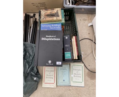
We found 1532 price guide item(s) matching your search
There are 1532 lots that match your search criteria. Subscribe now to get instant access to the full price guide service.
Click here to subscribe- List
- Grid
-
1532 item(s)/page

Lot 170
MINING and CORNWALL INTEREST. 'Spassky Photo Album.' 18 photos of the smelter and works at the Spassky Copper Mine, Kazakhstan between 1910 and 1918. These appear to have survived the Russian revolution, the 1919 civil war and the 'Cornish' owner's remarkable and harrowing escape from the Red Army and Siberia. Mounted in a Kodak album. The photos are presumably printed in Russia, some bearing the text '???????? ???????? – POCZTÓWKA – CARTE POSTALE' on the reverse. The album has descriptions written in ink. The reverse of some of the photos have notes in pencil. In very faint pencil on the inside cover is the name thought to be H.C. Robson. His story is taken from the book 'In the Kirghiz Steppes', J.W. Wardell, 1961: an account of the author's time at Spassky between 1914 and 1919. This, with the faint name, tends to support the album belonged to Robson. Spassky Copper Mine Ltd, was a British company mining copper on the Kirgiz steppes of southern Siberia (today: the Karaganda region of Kazakhstan). Harold C. Robson 'from Cornwall', he is known to have been at Spassky before 1914 employed as a smelter assistant. In 1916 he married Miss Florence May Townley who arrived in Spassky in September 1915 as the companion of the wife of the general manager (J.R. Horsley from England). In 1917 they had a son Michael. Robson was promoted to smelter superintendent (ie: manager) by 1918. Before the First World War the growth of heavy industries in Russia drew much British capital and personnel to the country. From 1914 the smelter and ore dressing plant at Spassky was modernised, designed by consulting metallurgical engineers Walter G. Perkins of London. Following the Revolution, the Spassky Copper Mines were nationalised on 27 March 1918. In increasingly fraught times the British staff of 10 staff, 5 women and 7 children prepared to leave Spassky. To raise finance for their journeys, and the travel light, they sold their surplus effects. They planned to travel to Petropavlovsk by horse and cart (510 miles, 5 days); and then west by train to Moscow; thence to Archangel and then by ship back to England. Robson sent his wife and child ahead of him, they arrived in Petropavlovsk on 28 May, he was to follow shortly. The town was controlled by the ill-disciplined Red Guard, the train station was controlled by the Czechs. On the 30 May, amongst much violence the town fell to the advancing Cossacks and White Guard. Robson arrived on the 4 June. Amongst many other refugees, there were not some 20 British isolated in squalid, infested conditions in Petropavlovsk. They were cut-off for 15 weeks. The children contracted whooping cough, scarlet fever and dysentery. Sadly their son, 1 year old Michael Robson, died of whooping cough. Early in July the Cossacks reached, and retook control of Spassky. The British staff were encouraged to return to continue producing copper. Before the end of the month the untrammelled staff had returned. Robson and wife returned in late August 1918. The operations were found to have been badly neglected, damaged and the mine flooded. With difficulty the operations were brought back into production. Apart from work, there was little the staff and families could do: they had sold most of their chattels before evacuating to Petropavlovsk. Basic supplies were difficult to come by. By mid 1919 the Red Army was increasing its control, the escape route to the west was now cut-off. On 21 July 1919 the British Consul advised the British to evacuate Spassky. The plan was to head east, and to avoid Red sympathisers they avoided villages and towns, then to escape by sea through Vladivostok or Shanghai. Robson and his wife planned to leave on 8 August, but illness prevented this. The party that left two days earlier arrived in Vladivostok on 2 September after travelling by cart and train, a distance of over 4,000 miles. The Robsons caught up with them and decided to try and get passage to Canada. The other party left for Shanghai on 28 September eventually arriving back in Southampton 26 November 1919 some 16 weeks after leaving Spassky. Shipping records show that the Robsons (and infant!) sailed on the ship 'Monteagle' arriving in Vancouver on 16 November 1919, they were destined for London. Travelling with them were fellow Spassky employees Humphry Quick (the assistant mine superintendent) destined for St Ives, Cornwall and Christopher George Dobby (secretary) destined for London. Those that evacuated Spassky in August 1919: Dobby C G (English, secretary from Sep 1915; Harbottle D E (Lancashire, colliery superintendent, pre June 1914); Harbottle Mrs (England) and 3 children; Morgan R J (New Zealand, mill superintendent, pre June 1914); Purvis R A (England, surveyor, pre June 1914); Purvis Mrs, pregnant and 2 children; Quick H (Cornwall, assistant mine superintendent, pre Jun 1914); Robson H C (Cornwall, smelter superintendent, pre Jun 1914); Robson Mrs, nee Townley, (England) and 1 child; Smith D G (British, mine superintendent, Jan 1918); Wardell J A (England, engineer, June 1914); Wardell Mrs (England) and 1 child; Whittick (British, smelter chemist, Jan 1918). Photos include: Spassky Smelter 1913 (might be 1910 or 1917); outside industrial buildings operating; 10ft Basic Copper Converter 1915; Spassky Copper Converter; Basic Converter Spassky 1917; Compressor Room Spassky Smelter; Spassky Smelter 1914, Old Slag-floor Spassky, outside, building being constructed?, quarry with workers, view of site, accommodation? And industrial factory?, 60" Acid-Converter Spassky 1910; Spassky Smelter-Yard and Crusher-sampling Plant; Fire-box end of Reverberating Furnace; Electric Power Station Spassky 1915; Slag-Dump-Spassky 1916 (1918 on reverse); Crusher Plant and Top Floor Smelter Spassky 1917. Credited to Mr Stephen Lay. ACSM, BSc, CEng, FIMMM. Associate of the Camborne School of Mines and Fellow of the Institute of Materials, Minerals and Mining. Mr Stephen Lay worked extensively across the former Soviet Union in exploration and mining. In 1999, by chance, he met in Tbilisi a descendant of JW Wardell who published his account of working at Spassky at the time these photos were taken. It is from his book that the accompanying detail has been drawn. Condition: The album will need some restoration. Mould, burn marks and sun bleaching have affected this album throughout. Considering the journey it has been on, it is remarkable it exists. Postage: £19.56 Please note that the postage quote is an estimate of the amount that we would charge to send the item to a buyer in the UK. If you are outside of the UK, or there is no estimate shown here, please contact postage@davidlay.co.uk for a bespoke quote.
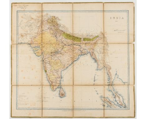
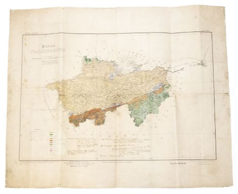
Lot 204
India.- Great Trigonometrical Survey of India.- Surveyor General's Office (Calcutta, India) India, sixth edition, detailed map of India and Ceylon, with part of the Indochinese Peninsula, after the original drawing by Indian cartographer Sunawullah, lithograph printed in blue and brown ink, by Romanath Dass and Buloram Nath, with some additional hand-colouring and plotting of trade routes, sheet 600 x 640 mm (23 1/2 x 25 1/8 in), dissected and mounted on linen, edged with green-coloured silk/linen, some splitting to folds, scattered spotting and surface dirt, owners ink inscription in the upper left corner that reads 'Return to H.J. Thompson/ 19 Portman Square/ London W', additional index maps of India pasted on verso, one section with marbled ends, 1865.
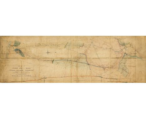
Lot 282
Railways.- Merret (H., Surveyor) Map of certain Intended Lines of Railway from St Helens to West Bank at Runcorn Gap..., manuscript plan, signed and dated by Merret, and also signed by the engineer, Charles Vignoles, the plan showing alternative routes for the proposed line with several branches, pen and ink, watercolour, 600 x 1850 mm (23 3/4 x 72 3/4 in), dissected and mounted on linen, several areas of small loss, repaired tears, surface dirt and stains, folding with purple-coloured endpapers, slightly worn, large 4to, 1829.
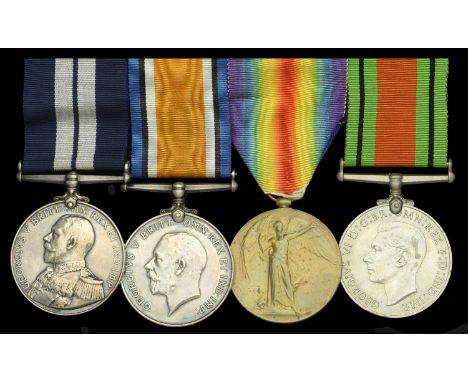
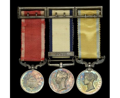
Lot 57
A well documented Great War ‘1917’ D.S.M. group of four awarded to Sergeant Observer W. C. Argent, Royal Naval Air Service, later Royal Air Force who undertook 201 anti-U-boat air patrols in seaplanes with 214 Squadron during the Great War, being forced to ditch 8 times in all and on one occasion seeing his bomb score a direct hit on the deck of an enemy submarine: details of Argent’s life and service are preserved in a series of interviews he recorded with the Imperial War Museum in 1991 Distinguished Service Medal, G.V.R. (F.13496. W.C. Argent. LG. Mech. R.N.A.S. 1917); British War and Victory Medals (213496. Sgt. W. C. Argent. R.A.F.); Defence Medal; together with the recipient’s associated miniature awards, both groups mounted as worn, nearly very fine and better (4) £1,400-£1,800 --- D.S.M. London Gazette 1 May 1918: ‘For zeal and devotion to duty during the period from 1st July to 31st December 1917.’ William Charles Argent was born on 25 January 1899 at Codicote, Hertfordshire and was educated in London at Brixton and Bonner Hill School, Kingston. He enlisted on 27 April 1916 as a Boy Mechanic in the Royal Naval Air Service and underwent Wireless Telegraphy training at Cranwell (held against H.M.S. Daedulus) until February 1917 at which time he was advanced to Air Mechanic Class II. After a short spell at gunnery and bombing school at Eastchurch he was posted briefly to R.N.A.S. Calshot as an wireless operator/air gunner before moving on to R.N.A.S. Portland. From 12 April 1917, Argent undertook 201 air patrols from Portland hunting submarines over the English Channel as an Observer in Short Seaplanes of 241 Squadron. On 15 May 1917 he attacked a U-Boat at location 31R, his log book stating: ‘dropped bombs on submerged sub. 31R. damaged it. TB.81 finishing it off.’ Engine problems were a consistent theme throughout 1917 causing many aborted climbs and premature landings and ditchings at sea (8 in total), the following logbook entries being not atypical: ‘9 July 1917 - forced landing, 40D, smashed floats on landing picked up after about 5 hours by T.B. 81. m/c towed to Lyme Regis a hopeless wreck’ ‘7 Sept. 1917 - nearly nose dived in sea, almost crashed into fishing smack, horrible wind-up’ On patrol on 20 July 1917, he saw a torpedoed ship going under with survivors being picked out of the oil-slicked sea by a trawler. Six days later he attacked another U-boat: ‘26 July 1917 - sub dived leaving some crew in water’ He was promoted to Leading Mechanic on 1 November 1917 and was awarded the D.S.M. for zeal and devotion to duty as an Observer during the latter half of that year. On 25 March 1918, Argent’s log book records a flight with Pilot Ensign Ives: ‘Sub spotted. 31Q. Dropped bomb which fails to explode.’ The following related note is then pasted into the recipient’s logbook: ‘Portland - Seaplane 9856 (Pilot Ensign F. Ives, U.S.N.) left at 1205 to cover the Eastern and Southern patrols, and at 1335, when in position 31R, an enemy submarine was sighted, fully blown, on the surface about half a mile away on the starboard bow. The seaplane overtook the submarine, then turned into the wind and attacked, dropping two 100-lb bombs from 600 feet. One bomb fell 10 feet astern of the submarine the other 10 feet ahead. Turning again, the seaplane dropped another 100-lb bomb, which fell directly on the deck of the submarine. All the bombs failed to detonate. By this time the submarine had submerged, leaving no wake. The seaplane came down low to drop a calcium flare on the spot, and after circling round for some time returned to base.’ In an interview with the Imperial War Museum the recipient describes that on this occasion he believes he sunk the U-Boat but having dropped flares at the location a destroyer later arrived and also depth charged the U-boat. Transferred as Corporal Mechanic to the R.A.F. on its formation on 1 April 1918, he remained based at Portland and advanced to Sergeant Mechanic on 30 July 1918. In June 1919, Argent was posted to R.N.A.S. Fort Grange, Gosport and he was demobilized to the R.A.F. Reserve on 9 November 1919. He served as a fireman with the Auxiliary Fire Service in London 1938-41 before returning to his work as a quantity surveyor after the Second World War. Argent died in Crawley, Surrey in 1999. Note: The Imperial War Museum’s Oral History sound archive contains a highly informative 1 hour 40 minute interview with Argent recorded in 1991. The interview covers the entirety of his life with a large portion devoted to his Great War service. Sold with the following: (i) The recipient’s three Flying Log Books: (a) Royal Naval Air Service Pilot’s Flying Log Book, S. 1516 first version (the word ‘Pilot’s’ scored through and replaced with ‘Observer’s’). Covering the period 12 April 1917 to 11 November 1918. Copious remarks. (b) Royal Naval Air Service Pilot’s Flying Log Book, S 1516, September 1917 revised version, (the word ‘Pilot’s’ scored through and replaced with ‘Observer’s’, and ‘Royal Naval Air Service’ scored through and replaced with ‘Royal Air Force’). Covering the period 12 April 1917 to 11 November 1918, with one additional entry on 14 May 1919. Copious remarks. (c) Pilot’s Flying Log Book, Army Book 425. Covering the period 12 April 1917 to 2 July 1918. This log book gives the appearance of having been filled out retrospectively. Fewer, more cursory remarks. Note: The reason for existence of the three log books covering roughly the same period isn’t clear. All three log books are in the same hand and contain similar but notably non-identical remarks relating to patrols. (ii) The recipient’s signed ‘Signal Card 1903’ booklet. (Reprint 1915 edition); Certificate of Transfer to Reserve on Demobilization, Army Form Z.21; Certificate of Employment During the War, Form Z.518; Air Training Corps Morse Code Instruction Certificate, A.T.C. Form 8, dated 20 April 1944; Invitation to founder members of the R.A.F. to attend 50th Anniversary events, dated 1 April 1968. (iii) An album (14.5cm x 11cm) containing 72 photographs, the former property of ‘Miss A. Goodspeed, 35 Chalford Rd. W. Dulwich’. Subject matter almost entirely Great War naval subjects including R.N.A.S. seaplanes, naval images of Gallipoli and the Mediterranean e.g. Mytilene. Possibly a combination of the recipient’s photographs and those of another family member. Although pasted into album, the photographs are mostly captioned on reverse. Together with a group portrait of twelve R.N.A.S. N.C.O.s in uniform, 15cm x 10.8cm.
Lot 162
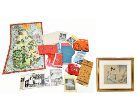
An early 20th century child’s silk outfit with matching hat, with floral decoration, together with an assortment of ephemera relating to Ceylon including maps and motor vehicle booklet, also a modern Chinese painting on silk depicting two figures in landscape setting.Additional InformationRegarding the printed map of Ceylon, it is a reproduction copy, it is stamped 'Printed and published under the direction of I.F. Wilson M.C Surveyor for General Caylon January 1849', but this is a copy of the original map and looks to be mid-20th century.
Lot 32
CUMMING THOS. (Surveyor). Plan of the Lands in Dispute between Major Hugh R. Duff of Muirtown & the Town of Inverness. 6 copies of this hand coloured eng. plan. July 1806; also various other maps & plans, some relative to the Duff estates & Reduced Plan of Ground in Dispute betwixt Murdo Mackenzie Esqre. of Dundonnell & Sir J. J. R. Mackenzie of Scatwell, 1843.
Lot 146
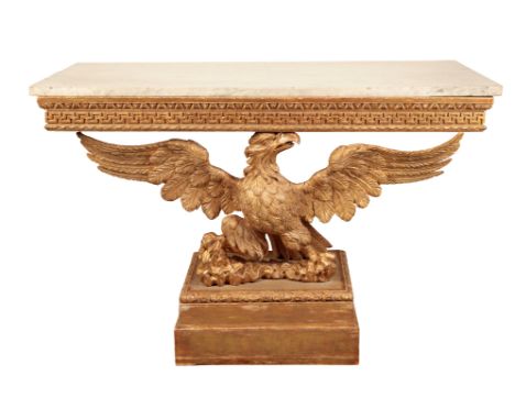
A GEORGE II GILTWOOD CONSOLE TABLE second quarter 18th century, The rectangular grey-veined white marble top above a echinus moulding and key pattern frieze, supported by an eagle with spread wings standing on a rocky base, on a square pedestal, restorations, regilt, 91cm high x 143cm wide x 76cm deepProvenance: with Hotspur, London, 1998.The use of an eagle as a support for a table was popularised in England by William Kent (1685/6 - 1748), the remarkable designer of furniture, objects, landscapes and architect. Kent’s designs drew on his decade in Italy from 1709-1719, spent mostly in the studio of the painter G. B. Chiari. On one of these last trips he travelled - at breakneck speed - with his fellow Yorkshireman (both were from the East Riding) Richard Boyle, 3rd Earl of Burlington (1694-1753) who was to provide patronage for Kent throughout his architectural career: Kent rose to the position of Deputy Surveyor of the King’s Works in the Office of Works, the department of the Royal Household responsible for architecture and buildings.Kent’s design for an eagle table support is likely to be derived from designs by Giovanni Giardini, published in Disegni Diversi, 1714 - in particular an elaborate table which featured an eagle with spread wings in the centre. Kent later used this design in an engraved tailpiece for Alexander Pope’s translation of Homer’s Odyssey, 1725-26. The earliest recorded eagle tables of this type were made for the Duke of Beaufort, between 1728-1733 by John Phillips, a carver, who was paid £444 9s 6d for work at Badminton House, Gloucestershire. Thomas Moore wrote to Dudley Ryder in 1734 about “an Eagle frame and Top Carved and guilded in burnished gold” which cost £12 (see catalogue entry to the pair of eagle tables in the Victoria & Albert Museum W.21-1945.1-2). Benjamin Goodison (1700-1767), whose workshop was at the ‘Golden Spread Eagle’ on Long Acre was one cabinet-maker who made furniture designed by Kent at Kensington Palace for George I (eg. the frame for Tintoretto’s The Muses RCIN 7405476) and for Frederick, Prince of Wales, probably at The White House, Kew (designed by Kent). While no eagle tables are known to have been made by Goodison, a pair of eagle tables was supplied around 1725 for Dudley North, at Glemham Hall, Suffolk (see Christie’s London, 12 November 1998, lot 80 - sold £150,000).

Lot 116
A PAIR OF GILDED AND PATINATED BRONZE SEVEN-LIGHT COLZA OIL HANGING LIGHTS of Regency style, 20th century, each with a colza oil vase reservoir in a shallow dish, with gadrooned underside terminating in a foliate boss, with seven scrolled branches holding brass tubes, with seven elaborately scrolled loops for seven suspension chains which extend from a cone receptacle inset into an acanthus ceiling rose, fitted for electricity, 97cm diameterProvenance: London Art Market, 1997.The Hall and Library at Stratfield Saye, Hampshire, seat of the Dukes of Wellington, features several similar Regency gilt bronze colza oil hanging lights. The house was redecorated in the post-war era by the aesthete, architect and former Surveyor of the King’s Works of Art, Gerald Wellesley (1885-1972), 7th Duke of Wellington. In the early part of the 20th century, Wellesley was intimately linked with collectors and connoisseurs responsible for ensuring the Regency style of decoration remained in vogue. This particular style was known as ‘Vogue Regency’ and found its singular expression in the interiors for Ralph Dutton, 8th Lord Sherborne (1898-1985) at Hinton Ampner, Hampshire. Lord Gerald Wellesley and the architect Trenwith Wills, guided the original alterations to the house which were carried out in 1936 and the post-1960 fire redecoration.
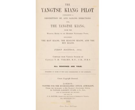
Lot 36
Tizard (Thomas Henry). The Yangtse Kiang Pilot, containing a description of, and sailing directions for, the Yangtse Kiang, from the Wusung River to its highest navigable point, including the Han Kiang, the Kialing Kiang, and the Min Kiang, 1st edition, Hydrographic Office, Admiralty, 1914, black and white plates and illustrations including folding charts and diagrams, a little spotting, original cloth, slightly rubbed and soiled, spine browned, 8voQty: (1)NOTESThomas Henry Tizard (1839-1924), oceanographer and hydrographic surveyor, served on board HMS Challenger between 1872 and 1876, and was author of several portions of the Challenger Reports.
Lot 755
Jared Hill (Early 18th Century English School) - Ink and watercolour on vellum - "A Mappe and Defcription of Feveral Eftates in the County of Kent Belonging to Peter Godfery Efq... Made by Me Jared Hill, Surveyor in Canterbury. 1722.", with scale, table and Peter Godfery's arms, within border of running acanthus leaves, 28.75ins x 40.75ins, in oak frame and glazed Provenance: The Canterbury Auction Galleries, ex Bill Deedes sale, Aldington, Ashford, Kent
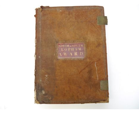
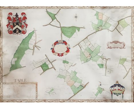
Lot 4291
Inclosure Acts, 'North and South Lopham Award', a large folio volume circa 1812-1815, containing a long manuscript vellum legal document relating to land in North & South Lopham, Norfolk, the commissioners Thomas Lanchester of Coney Weston, Thomas Archer of Barton Mills, Harry Browne of Diss, and John Housman of North Lopham, the first meeting of the commissioners taking place at the White Horse Inn, South Lopham, 25th May 1812, two folding vellum documents at front signed by the aformentioned commissioners, preceding 108 vellum pages of manuscript entries re North & South Lopham land boundaries, public carriage roads & private roads, repairs of roads, public footways, allotment for the poor, allotment for public land and gravel pits, then listing allotments to proprietors, all listed by name in alphabetical order for North Lopham, then South Lopham, including at beginning "Allotment to the Most Noble Charles Duke of Norfolk for Rights of Soil in North Lopham", allotment exchanges between proprietors and said Feoffes, then at end adjudication, directions respecting fences, stewards fees, expenses, tables for N. & S. Lopham listing proprietors and proportionate amounts, plus large folding hand coloured manuscript plans of North & South Lopham at end titled "Map of the Parish of North Lopham in the County of Norfolk referring to the Award of 1815", scale 9 chains to an inch, Browne & Taylor, surveyors, and "Plan of South Lopham as refers to the Award annexed 1815", R Payne, Surveyor, each approx. 58 x 75cm, each signed Harry Browne & Thomas Archer verso, large folio (59 x 43cm), original reverse calf, morocco gilt title label to upper cover, metal clasps; plus Serpell: 'A History of the Lophams', 1980, 1st edition (2)
Lot 4302
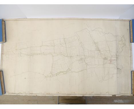
A large 19th Century manuscript plan of Diss, Shelfanger, Winfarthing, The Heywood & environs, showing land divisions and land owners, hand colouring, scale 8 chains to an inch, signed John Josseyln [of Sproughton, Suffolk, land agent & surveyor], some wear/light waterstaining, tape repairs verso, approx. 131 x 77cm, rolled
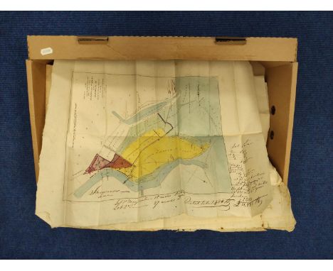
Lot 227
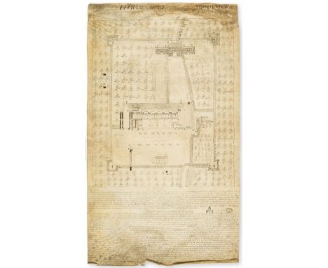
Eltham Palace.- Robinson (Samuel, surveyor, based at Cockhill, Shadwell, fl. 1741) A Draught of Eltham Court Described in a South View Taken the 4th Day of December 1741, manuscript on vellum, 1½pp., in italic, large pen and ink sketch of the Great Hall, gatehouse and orchards of Eltham Palace, folds, waterstained at head, soiled and browned but text clearly legible, 710 x 430mm., [London], 1741.⁂ A description of Eltham Palace at the height of its decay in the middle of the eighteenth century. Parliament sold the palace in 1651 to Colonel Nathaniel Rich who demolished some of the buildings and stripped the lead off the roof of the Great Hall. By the time of this survey the remains of the palace was a farm and the Great Hall was used as a barn.Provenance: Robinson is recorded as surveying in the same manner, the Pilgrim's House, Hackney, now in the V&A, and 2 surveys relating to Saint Dunstan and All Saints' Church, Stepney, and West Ham Abbey, West Ham in London Metropolitan Archives. The V&A records that their survey was in the collection of John Edmund Gardner (1819-99), dispersed in 1924 after his death.

Lot 491
Paul Calle (American, 1928 - 2010) and Chris Calle (American, B. 1961) "Space Exploration Captivates Millions" Signed lower right. Original Watercolor/ Mixed Media painting on Illustration Board. Provenance: Collection of James A. Helzer (1946-2008), Founder of Unicover Corporation. This painting is the original which was published on the Republic of the Marshall Islands The 20th Century Series 60c Space Exploration Captivates Millions stamp issued March 15, 2000. In the 1990s, people around the world were captivated by space exploration. On April 24, 1990, the space shuttle Discovery launched the Hubble Space Telescope. On September 11, 1997, NASA's Mars Global Surveyor began orbiting the red planet for a two year mapping survey of the entire Martian surface. On July 4, 1997, NASA's Pathfinder and its semi-autonomous rover Sojourner successfully landed on Mars. After Pathfinder's touchdown, Sojourner -- a microwave oven-size vehicle -- traveled down a ramp and began exploring its alien surroundings. For the first time in the history of America's space program, the Mars Pathfinder mission demonstrated the ability of engineers to deliver a semi-autonomous roving vehicle, capable of conducting science experiments, to the surface of another planet. Image Size: 9 x 13 in. Overall Size: 13 x 20 in. Unframed. (B16755 / B16756)
Lot 350
Young, William Weston. British Birds, An album of 41 fine watercolour drawings of birds, each 163mm x 257mm approx.., mounted in frame, most captioned in pencil on mount, lacking free-endpapers, nineteenth century calf, the upper cover blocked in gilt 'William Weston Young. British Birds. Neath 1804', expertly rebacked by Bayntun of Bath, c.1940, 4to A RARE SERIES OF ORNITHOLOGICAL WATERCOLOURS FROM AN ARTIST WHO WORKED AT THE CAMBRIAN POTTERY. William Weston Young was born in Bristol on 20 April 1776 into a devout Quaker family, the third son of Edward Young, a Bristolian merchant and Sarah (Sally) Young (née Weston). William led a diverse and entreprenuerial life, but an early bankruptcy forced him into paid employment. On 23 January 1803, Young and his wife Elizabeth moved to new lodgings in Swansea, Glamorganshire. Here he gained employment under fellow Quaker, Lewis Weston Dillwyn, as a 'draftsman' at Dillwyn's Cambrian Pottery, where he remained until August 1806 on a salary of £75 per annum. The watercolours in the present lot would seem to date from this period. Dillwyn and Young, both in their mid-twenties, struck up a close friendship due to their common interest in natural history. Many of Young's painted wares feature accurately depicted flora and fauna as well as the taxonomic names of the illustrated species. Collections of this pottery can be seen at the V&A Museum, South Kensington, The National Museum of Wales, Cardiff and at the Glynn Vivian Art Gallery, Swansea. In 1814, and now recovered from his debts, Young became the major investor in the Nantgarw Pottery established by William Billingsley and Samuel Walker. When the pair left the struggling business in 1820, Young assumed full control, and managed the debts through careful marketing and sale of remaining stock. Young's experience of firing ceramics, together with his familiarity with the region as a local surveyor and his amateur interests in geology enabled him to conceive of a heat-proof, blast-furnace brick, using silica found in large deposits at the head of the Neath Valley. His profit share from the Dinas Firebrick Works was ultimately a very modest pension, and William Weston Young died in relative poverty in Lower Mitton, Kidderminster on 5 March 1847. PROVENANCE: Loosely inserted are three ALS and a carbon typed copy from the bookseller J. Kyrle Fletcher to the purchaser F. E. Andrews, relating the discovery of the album. The first, dated 13 February 1935 notes, 'Mr William Weston Young made the drawing for Mr Dillwyn's valuable work on British Confervae and a series of drawings of British Birds now in the possession of Mr Yarrell'. The correspondence relates that the bookseller traced the descendants of Yarrell and acquired the volume, which was sold to Andrews in 1941, thence offered here by descent.
Lot 392
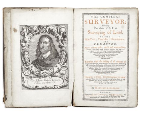
LEYBOURN (William) Philomathematicus, 'The Compleat Surveyor'. Seven books in one volume, numerous diagrams, tables etc. Sawbridge at the Signe of the Bible on Ludgate-Hill. 1679. Red and black print on title page, end papers with m/s note, owners sigs. doodles etc. Small Fo. (304 x 195mm). Full contemporary calf. Lacks frontispiece and plates (?). Some mispagination
Lot 180
A Richard Cushee 2 ¾-inch pocket globe, published 1731 English, circa 1731,the cartouche printed A New Globe of the Earth. R Cushee 1731, the papier-mache sphere applied with twelve copper engraved gores and two polar calottes, California is drawn as an island and Australia is represented according to the Dutch discoveries, the black fish-skin case has a celestial globe on the two inner hemispheres applied with twelve sets of hand coloured half gores, 3in (7.5cm) diameter Footnotes:Provenance:Christie's, London, 1967.The Stephen Edell Collection.Richard Cushee was a globe maker and surveyor who worked at the sign of the Globe and Sun, between St Dunstan's Church and Chancery Lane in Fleet Street, London. In 1731, together with Thomas Wright, he published a book by Joseph Harris: The description and use of the globes, and the orrery. The pocket globes made by Cushee were used by Wright in the construction of his orreries.Literature:Elly Decker, Globes at Greenwich, London, 1999.Sylvia Sumira, The Art and History of Globes, London, 2014.For further information on this lot please visit Bonhams.com
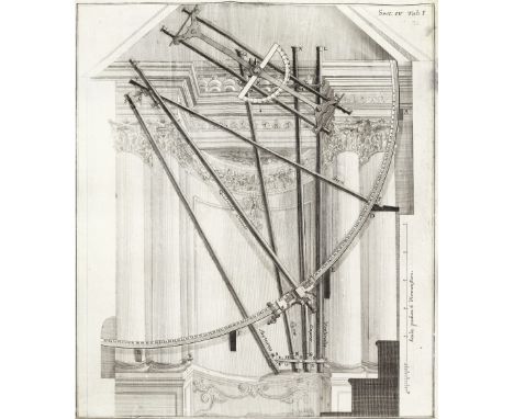
Lot 11
MARINONI (GIOVANNI GIACOMO)De astronomica specula domestica et organico apparatu astronomico libri duo, FIRST EDITION, engraved frontispiece by J.J. Sedelmayr after A.D. Bertoli, title printed in red and black with a vignette map of Vienna engraved by J.C. Winkler, 43 engraved folding plates, engraved illustrations (7 full-page), one engraved initial by Winkler, woodcut initials and head-pieces, with final errata and instructions to the binder in Latin and German leaf, some mold stains in blank upper margins, with the first few leaves restored, modern calf preserving some sections of original backstrip, red edges [Kenney, Catalogue of the Rare Astronomical Books in the San Diego State University Library, 115; Poggendorff II, 53; Riccardi II, 119, 'Bellissima ediz.'], Folio (346 x 245mm.), Vienna, Leopoldus Joannes Kaliwoda, 1745Footnotes:First edition of 'one of the most exquisitely illustrated astronomical works ever printed' (Kenney), describing and illustrating the astronomical instruments in the private Viennese observatory of G.J. Marinoni, mathematician and astronomer to the Imperial Court of Austria and geodetic surveyor. The observatory was one of the most beautiful and best equipped in Europe, and the instruments illustrated here include quadrants, telescopes, micrometers, an improved Graham pendulum, and a camera obscura.This copy is complete with the errata/instructions to the binder leaf at the end (Riccardi mistakenly calls for 2 leaves rather than pages, leading to some copies being described as lacking the second errata leaf).This lot is subject to the following lot symbols: •• Zero rated for VAT, no VAT will be added to the Hammer Price or the Buyer's Premium.For further information on this lot please visit Bonhams.com
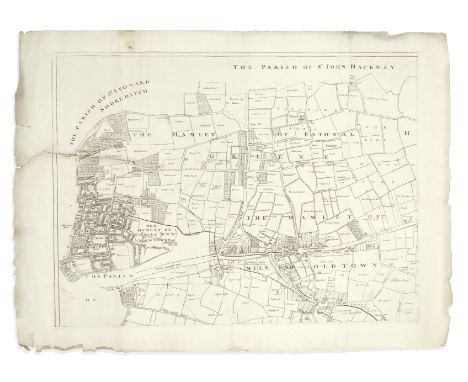
Lot 43
LONDON - EAST END, 1703GASCOYNE (JOEL) An Actuall Survey of the Parish of St Dunstan Stepney, alias Stebunheath, Being One of the Ten Parishes in the County of Middlesex adjacent to the City of London... Taken Anno. Dom. 1703... Engraven by John Harris, large engraved map on 8 irregularly sized sheets, large ornamental title cartouche incorporating an image of St. Dunstan pinching the devil's nose with a pair of Goldsmith's tongs, all sheets with platemarks visible and good borders, 2 sheets with one horizontal tear extending c.140mm. in from the platemark (but no loss), a few edges slightly frayed, largest sheet 510 x 610mm., smallest 106 x 160mm., overall approximately 1110 x 1150mm., Joel Gascoyne, 1703Footnotes:RARE MAP OF THE EAST END OF LONDON, ON 8 SEPARATE SHEETS. Drawn up by the surveyor Joel Gascoyne (1650-705), the map extends from Spitalfields to the River Lea, and Bethnal Green to the Isle of Dogs, encompassing the parishes of Limehouse, Poplar, Mile End Old and New Towns, Ratcliff, Wapping, Spitalfields, Bethnal Green, Bromley and Bow. The irregular size of the sheets, in addition to the East End being at this time an unfashionable working area with much of it yet to be built upon (the Isle of Dogs is all but empty), are perhaps reasons the map is scarce. Each sheet of this set has the platemark and full margins, and appears never to have been stitched or bound.This lot is subject to the following lot symbols: •• Zero rated for VAT, no VAT will be added to the Hammer Price or the Buyer's Premium.For further information on this lot please visit Bonhams.com
Lot 72
CLARENDON (EDWARD HYDE, EARL OF)The History of the Rebellion and Civil Wars in England, Begun in 1641, 3 vol., mixed edition, half-titles, engraved frontispiece portraits, engraved vignettes and decorations, some dampstaining to opening leaves (resulting in small losses to upper gutter border of half-title and title of volume 1, and repair with small loss to frontispiece of volume 1, contemporary uniform red morocco gilt, sides with elaborate panel design of various roll-tool borders enclosing central ownership name 'W. Culliford, Encombe, 1710', ornamental corner-pieces, spines tooled in 8 compartments within raised bands, t.e.g., worn, some scuffmarks to sides (obscuring some letters of text on 2 panels, one with small area gouged out), losses to extremities of spines, folio (445 x 280m.), Oxford, at the Theatre, 1707[-1703-1704]; together with a manuscript indenture, with seal, signed and dated 10 December 1669 by Robert Culliford of Encombe, relating to dealings with Sir William Constantine of Morl, John Tregonwell of Anderson, and Thomas Baynard of Cliffe (4)Footnotes:QUEEN ANNE BINDINGS MADE FOR A DISTINGUISHED DORSET FAMILY, CELEBRATING THEIR LINKS TO CLARENDON AND THE ROYAL CAUSE. Provenance: William Culliford (c.1640-1723), gilt lettered 'W. Culliford 1710' on sides, with large contemporary letterpress label inside each volume, 'Part I. [-II-III]. All the parts of the Earl of Clarendon's History, bequeath'd by my will to my son John Culliford and his Heirs Male for ever, are to remain in this House of Encombe, in perpetual Memorial of the Unhappy Rebellion begun in 1641, and the sad and miserable effects is produced in this Kingdom.... Dated the 20th of September 1710. Will. Culliford'. Loosely inserted is a 2-page letter written, circa 1760, by another William Culliford to an unidentified recipient relating to these books and several paintings, contesting a claim that the recipient had either been gifted them by Culliford's father, or purchased them at auction. He demands 'that you will send me the Historys by the next... stage, and if you insist upon being paid for them... you shall be paid whatever a Bookseller in Southampton shall value them at...'.Culliford 'was the younger son of Robert Culliford (1617–1698), of a Dorset gentry family, and his wife, Elizabeth Lawrence. His father, a somewhat tepid royalist in the civil war, was a cousin of Lord Chancellor Clarendon, though whether this was the cause of William's first appointment, as an excise surveyor in 1666, is not known. His promotion to a more responsible post as register of seizures in the customs took place after Clarendon's fall...' (ODNB). Amongst other notable positions Culliford represented the seat of Corfe Castle, Dorset in Parliament between 1690 and 1699. The books did remain at Encombe, as shortly after William's death the estate was sold to the Pitt family.This lot is subject to the following lot symbols: •• Zero rated for VAT, no VAT will be added to the Hammer Price or the Buyer's Premium.For further information on this lot please visit Bonhams.com
Lot 138
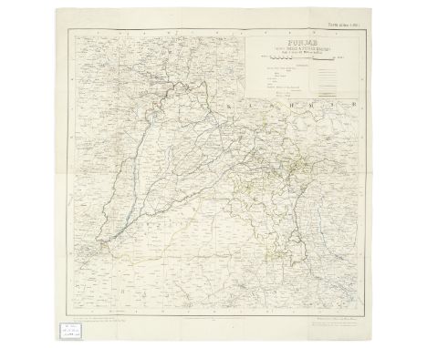
MAPS - COLLECTIONTourist Map Jammu & Kashmir State... Printed at the Request of the Chief Conservator of Forests, heliozincographed, some lakes and waterways hand-coloured in blue, one corner missing (not touching map area), a few small tears at folds, c.1390 x 1115mm., [1939]--Quetta and Surrounding Country, colour-printed, laid on linen, stamped 'For Official Use Only. Restricted' in red, c.1120 x 820mm., Printed under direction of Brigadier H.J. Couchman, Surveyor General of India, March 1944--Punjab (Also Delhi & Punjab States)... New Edition..., heliozincographed map printed in colours, backed on linen, Ex libris plate of R.A. Scoales in corner, c.610 x 570mm., Calcutta, Survey of India, 1928, all folding maps; and c. 24 other folding, mostly pre-1949 maps of India, including Multan City, Rawalpindi, Lucknow, Delhi, Lahore, etc. (quantity)This lot is subject to the following lot symbols: •• Zero rated for VAT, no VAT will be added to the Hammer Price or the Buyer's Premium.For further information on this lot please visit Bonhams.com
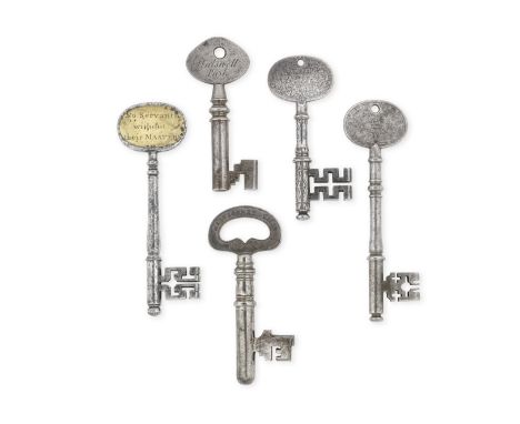
Lot 47
A collection of five Georgian keysThe first with a bow engraved with cypher for William IV and the reverse engraved 'Botanic Gardens No.1', together with another engraved, 'Rt. Hon. Ld. Clifford, Halswell Park', another with brass inlaid bow marked, 'Hyde Park Barrs, No Servants without their MASTERS', a further example with the bow engraved with cypher for George III and the reverse engraved for the assistant surveyor general of H.M. Works and another marked 'Master Key Cells No. 1', The largest 12cm (5)Footnotes:For the Hyde Park Barrs key comparison see 'The Lure of The Key', William Wallace pages 74 and 75.For further information on this lot please visit Bonhams.com
Lot 357
Australia. Wells (W. H. Land Surveyor), A Map of the County of Cumberland in the Colony of New South Wales, Sydney, circa 1860, uncoloured lithographic map, laid on linen, slight spotting and dust soiling, some creasing, numerous repaired closed tears affecting image, 830 x 535 mmQty: (1)NOTESA scarce map centred on Sydney and Botany Bay.
Lot 258
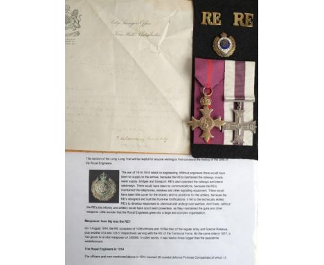
A WWI Military Cross pair to Second Lieutenant Gilbert Hart, 173rd (Tunnelling) Company Royal Engineers, comprising George V OBE (Military) maker Garrad & Co, London 1919 and Military Cross: together with a letter from the City Surveyors Office, Town Hall Manchester.'Dear Mr Hart. I was very pleased to receive, this morning, your letter of the 17th instant, informing me that you had been awarded the Military Cross. I congratulate you upon the honour, which has been conferred upon you , and I wish you every success. Yours faithfully J deLauncey Meade. City Surveyor.'framed and mounted together with brass 'RE' shoulder badges and a gilt and enamel Royal Engineers lapel badge in a glazed display case and a folio of related research material including a Town Council missive 'Resolved, That this committee desire to place on record the pleasure with which they have learnt of the distinguished service rendered by Lieutenant Hart in France, and to convey to him their congratulations of the well deserved honour of the Military Cross which has been bestowed upon him by his Majesty...'
Lot 247
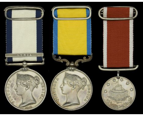
Three: Captain R. B. Creyke, Royal Navy Naval General Service 1793-1840, 1 clasp, Syria (R. B. Creyke, Mate.); Baltic 1854-55, unnamed as issued; St. Jean d’Acre 1840, silver, unnamed as issued, fitted with contemporary replacement silver bar suspension, each medal fitted with silver ribbon buckle and long pin for wearing, nearly extremely fine (3) £1,000-£1,400 --- Provenance: Glendining’s, March 1998, when mounted in glass fronted display case, the black-on-gold painted labels from which accompany the group. Richard Boynton Creyke entered the Navy in July, 1829, as first-class volunteer on board the Atholl, on the west coast of Africa, from which vessel, in April, !831, he was transferred to the Medina, where he remained until July of the same year. He joined the Ocean as a midshipman in December, 1831, the Magpie in November, 1832, and the Rolla in November, 1833. In these vessels he was employed at Sheerness, and on the North Sea and Lisbon stations. He went to the Mediterranean in April, 1834, in the Revenge, and as a Mate became attached to the Bellerophon in May, 1838. In the Bellerophon, as a Mate, he took part in the operations on the coast of Syria, and was present at the bombardment of St. Jean D’Acre. In July, 1841, he was appointed to the revenue cutter Defence, employed in the North Sea, and was transferred, in July, 1843, to the steam vessel Blazer, Captain John Washington (afterwards Hydrographer) employed on surveying service in the same neighbourhood. He was promoted to the rank of Lieutenant in September, 1843. From February, 1844, to October, 1845, he served on the west coast of Africa in the Penelope, Alert, and Growler, the former being the Commodore’s vessel on that station. He commanded the boats of the Alert in an attack on pirates at the Arguin islands, near Cape Blanco, for which he was mentioned favourably in the despatches of the Commodore. In January, 1846, he was appointed to the survey of the west coast of Scotland, under Captain C. G. Robinson, in the Shearwater, and in October of the same year was made an Assistant-Surveyor. In October, 1847, his name was transferred to the books of the San Josef and subsequently to the Impregnable and Fisgard, his services throughout being continued in the survey of the west coast of Scotland. In February, 1855, Lieutenant Creyke was appointed First Lieutenant of the Merlin, Captain Bartholomew J. Sulivan, attached to the Baltic fleet, in which vessel he assisted in surveying the north part of Cronstadt, as well as the vicinity of Sweaborg, previous to its bombardment, at which he was present. For his services on this occasion he was so strongly recommended by the Commander-in-Chief to the favourable consideration of their lordships, that he was promoted to the rank of Commander in September of the same year, and in the following November again resumed his duties as an Assistant-Surveyor on the west coast of Scotland, under Captain E. J. Bedford, with whom, as Chief Assistant-Surveyor, he continued to serve until about the year 1861. He was promoted to be Retired Captain on 11 February 1862, in consideration of his services and the impaired state of his health. For his war services Captain Creyke has received the Syrian and Baltic medals. For the recipient’s miniature dress medals, see Lot 639.
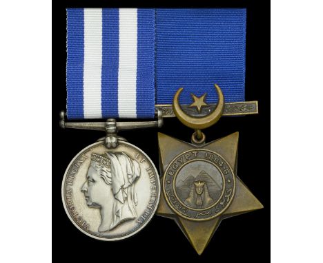
Lot 271
Pair: Lieutenant J. H. C. East, Royal Navy Egypt and Sudan 1882-89, undated reverse, no clasp (Lieut.J. H. C. East, R.N. H.M.S. Myrmidon.); Khedive’s Star 1884-6, unnamed as issued, good very fine (2) £400-£500 --- James Henry Cunningham East was born in Kingstown, Co. Dublin in March 1858 and entered the Royal Navy as a Cadet in Britannia in January 1871, aged 12 years. Advanced to Sub. Lieutenant in March 1877, he served aboard H.M.S. Warrior between May and August 1878, which famous ship may now be seen at Portsmouth, fully restored. East next joined the survey ship Alert, an appointment that lasted until September 1882. During that period the Alert, commanded by Captain G. S. Nares, the famous Arctic explorer, carried out an extensive survey in South American waters and in the South Pacific, details of which appear in British Oceanographic Vessels: ‘The Alert sailed from Plymouth in September 1878 via Madeira, St. Vincent, Montevideo and the Falkland Islands, reaching the Strait of Magellan on New Year’s Day 1879. Throughout 1879 and the first half of 1880 the Alert surveyed the coast of Patagonia, Nares being recalled and replaced by Captain J. L. P. Maclear, his second-in-command on the Challenger, in spring 1879. Leaving South America in June 1880, the Alert sailed via Tahiti and Fiji to Sydney, arriving in January 1881. After six months surveying off the eastern and northern coasts of Australia the ship sailed to Singapore for a refit where she was ordered to survey Amirante and neighbouring islands in the south-western Indian Ocean. These surveys were conducted between March and May 1882 and the Alert then returned to England via South Africa, St. Helena and the Azores, arriving at Plymouth in September.’ A full account of the expedition by the ship’s surgeon, R. W. Coppinger, was published in London in 1885, under the title Cruise of the Alert: Four Years in Patagonia, Polynesian and Mascarine Waters, 1878-82. Passing his examinations for 2nd Class Assistant Surveyor in September 1884, while serving in the Myrmidon, another survey vessel, East witnessed active service off the Sudan in the same ship, surveying in the Red Sea during the Egyptian campaign, especially in 1884, off Suakin, Port Berenice, Hanish Island and Zeila. It was noticed variously that ‘Eyes weak from survey in Red Sea’, ‘Eyesight will not bear a long continued strain of work’, and on 12 May 1885, he was invalided with ‘retinal paralysis’. Following various surveys and re-surveys [of his eyesight] until 28 November 1885, he was sent to Belleisle. He was in Thalia from November 1887 to March 1888, whither the Khedive’s Star was sent. East returned to Myrmidon as Senior Lieutenant from 1 April 1888 to 31 January 1889, whence he transferred to Rambler when the crew from one transferred to the other. From Rambler, he was ‘discharged dead’ on 24 January 1890, having died at Albany, Western Australia, on that date aged 31 years, the reason being given as ‘climatic fever’. He is probably buried in Albany. Sold with copied record of service.
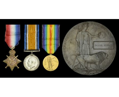
Lot 29
Three: Captain S. Roberts, Royal Engineers, who committed suicide at Rouen on 6 December 1914 1914 Star (Hon: Capt: S. Roberts. R.E.); British War and Victory Medals (Capt. S. Roberts.); Memorial Plaque (Samuel Roberts) nearly extremely fine (4) £200-£300 --- Samuel Roberts was born in 1874 at Plymouth, Devon and was appointed Assistant Surveyor (ranking as Lieutenant) in the Staff for Engineer Services on 1 May 1899. He was advanced Inspector (with the honorary rank of Captain) on 1 April 1907 and served in that rank on the Staff for Royal Engineer Services during the Great War on the Western Front. Captain Roberts committed suicide at Rouen, France on 6 December 1914. He was the husband of Florence M. Roberts of 10 Beaumont Road, Plymouth and is buried in St. Sever’s Cemetery, Rouen, France.
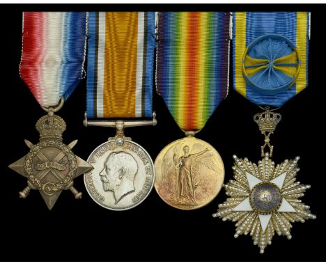
Lot 312
Four: Commander W. J. Bright-Barton, Royal Navy 1914-15 Star (Lieut. W. J. B. Barton. R.N.); British War and Victory Medals (Lt. Commr. W. J. B. Barton. R.N.); Egypt, Kingdom, Order of the Nile, 4th Class breast badge by Lattes, silver, silver-gilt and enamels, mounted as worn, good very fine (4) £240-£280 --- Order of the Nile, 4th Class, London Gazette 15 June 1920. Walter Jeremy Bright-Barton was born in Preston, Lancashire, on 20 June 1888. He was appointed Midshipman on 30 January 1905; Sub Lieutenant, 30 March 1908; Lieutenant, 30 March 1910, and, in March 1912, joined his first surveying unit Daisy, tender to Hearty, as an Assistant Surveyor 4th Class (H4). On 1 January 1914, he advanced to H3, and in the same month gained a Board of Trade certificate as Master. On 6 March 1914, he transferred to Mutine (a surveying sloop), but in August 1914 was appointed to Suffolk (addl. for surveying at Bermuda) and in September 1914 to London in the Grand Fleet and later in the Mediterranean but not, seemingly, in a surveying role. In May 1916 he went to Hearty until October 1916, having advanced to H2 on 1 August, and then spent 11 months in Powerful before joining Grafton, a cruiser, on 17 September 1917 ‘for staff of Rear-Admiral’ for surveying duties until June 1919, where he succeeded Haselfoot as the producer of local surveys, charts and Notices to Mariners. This ship was the flagship of Rear-Admiral, Egypt, with staff ashore in Ismalia from May 1918. He was promoted to Lieutenant-Commander on 30 March 1918. In January 1919, Rear-Admiral Jackson wrote that he had ‘done very useful work in Egypt and maintained ex[cellent] relations with the Egyptian civil servants.’ From June 1919 to 1929, he was a Naval Assistant in the Hydrographic Department as the Jacketting Officer, and was placed on the Retired List at his own request with rank of Commander on 4 August 1931. On 1 January 1940 he was appointed inside Admiralty with Hydrographer but in what role is not recorded. Released on 31 December 1945, he reverted to the Retired List and died on 5 May 1946. Sold with copied record of service.
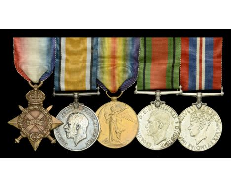
Lot 314
Five: Lieutenant-Commander E. M. Gibbings, Royal Navy 1914-15 Star (Lieut. E. M. Gibbings. R.N.); British War and Victory Medals (Lt. Commr. E. M. Gibbings. R.N.); Defence and War Medals 1939-45, mounted as worn, very fine (5) £100-£140 --- Edward Maurice Gibbings was born in Cork on 8 July 1887, and joined Britannia on 15 September 1902, aged 15 years 3 months; Midshipman, 29 February 1904; Acting Sub Lieutenant, 30 April 1907; Lieutenant, 31 December 1909; Lieutenant-Commander, 31 December 1917. Much of his early career was spent on the China station in Cressy, Hogue, and Britomart. In August 1910 he joined the surveying ship Hearty working in the North Sea and this seems to have encouraged him to specialise as a Hydrographic Surveyor, being made an Assistant Surveyor 4th Class on 6 August 1911, advancing to 3rd Class on 1 October 1912, to 2nd Class on 1 January 1915, and to 1st Class on 18 May 1919. He served in Fantôme from September 1911 to May 1913, returning to Hearty until the outbreak of war when he seems to have been appointed as Navigating Officer in the destroyer Recruit, leaving her in January 1915, transferring to the depot ship Woolwich still in a navigating role. He returned to surveying in Hearty once more in September 1915, transferring to command Esther survey vessel in May 1916 and remaining in her until 24 March 1917. During this period in command he worked in the Thames Estuary and Medway, mainly on war operations involving minelaying. In March 1917, he was sent to Endeavour working in the Mediterranean but he left her in November 1919 under a cloud, having been charged with drunkenness. Although he was acquitted (not proved) this was the start of his rapid fall from grace through his relationship with alcohol and he was placed on the Retired List on 11 September 1923, at the age of only 36. In July 1939 he seems to have been given a second chance with an appointment to Osprey for anti-submarine training and was then appointed to Dunluce Castle in November 1939. However, in mid-February 1940 the Captain reported that Gibbings had been drunk on board, and on 18 February 1940, he left her and reverted thereafter to the Retired List. Later during the war he is shown as a Lieutenant in the Home Guard, serving in the Aldershot District of South-Eastern Command in the 12th Surrey (3rd Southern Railway) Battalion. Sold with copied record of service and other research.
Lot 639
The group of three miniature dress medals attributed to Captain R. B. Creyke, Royal Navy Naval General Service 1793-1840, 1 clasp, Syria; Baltic 1854-55; St. Jean d’Acre 1840, silver, mounted on triple ribbon brooch bar with steel pin for wearing, nearly extremely fine (3) £200-£300 --- Richard Boynton Creyke entered the Navy in July, 1829, as first-class volunteer on board the Atholl, on the west coast of Africa, from which vessel, in April, !831, he was transferred to the Medina, where he remained until July of the same year. He joined the Ocean as a midshipman in December, 1831, the Magpie in November, 1832, and the Rolla in November, 1833. In these vessels he was employed at Sheerness, and on the North Sea and Lisbon stations. He went to the Mediterranean in April, 1834, in the Revenge, and as a Mate became attached to the Bellerophon in May, 1838. In the Bellerophon, as a Mate, he took part in the operations on the coast of Syria, and was present at the bombardment of St. Jean D’Acre. In July, 1841, he was appointed to the revenue cutter Defence, employed in the North Sea, and was transferred, in July, 1843, to the steam vessel Blazer, Captain John Washington (afterwards Hydrographer) employed on surveying service in the same neighbourhood. He was promoted to the rank of Lieutenant in September, 1843. From February, 1844, to October, 1845, he served on the west coast of Africa in the Penelope, Alert, and Growler, the former being the Commodore’s vessel on that station. He commanded the boats of the Alert in an attack on pirates at the Arguin islands, near Cape Blanco, for which he was mentioned favourably in the despatches of the Commodore. In January, 1846, he was appointed to the survey of the west coast of Scotland, under Captain C. G. Robinson, in the Shearwater, and in October of the same year was made an Assistant-Surveyor. In October, 1847, his name was transferred to the books of the San Josef and subsequently to the Impregnable and Fisgard, his services throughout being continued in the survey of the west coast of Scotland. In February, 1855, Lieutenant Creyke was appointed First Lieutenant of the Merlin, Captain Bartholomew J. Sulivan, attached to the Baltic fleet, in which vessel he assisted in surveying the north part of Cronstadt, as well as the vicinity of Sweaborg, previous to its bombardment, at which he was present. For his services on this occasion he was so strongly recommended by the Commander-in-Chief to the favourable consideration of their lordships, that he was promoted to the rank of Commander in September of the same year, and in the following November again resumed his duties as an Assistant-Surveyor on the west coast of Scotland, under Captain E. J. Bedford, with whom, as Chief Assistant-Surveyor, he continued to serve until about the year 1861. He was promoted to be Retired Captain on 11 February 1862, in consideration of his services and the impaired state of his health. For his war services Captain Creyke has received the Syrian and Baltic medals. For the recipient’s full size medals, see Lot 247.
Lot 11
* Mountaineering. A collection of letters & photographs relating to mountaineering expeditions etc., mostly early 20th c., including a small selection of 28 monochrome photographs of an expedition across Norway to the Arctic with views of Mt. Newton, Mt. Irvine, view from the ship Temingen and images of various camps with expedition members Milling, Frazer & Odell (many captioned to verso, all three mentioned were part of the Oxford 1923 expedition to the Arctic), each approx. 10.8 x 8 cm, together with two menu cards for the Alpine Club Winter Dinner, 12 Dec. 1911 and the Fell & Rock Climbing Club, 7th Dec. 1929, plus a 19th century chromolithograph view of figures in an alpine pass, image 54 x 40 cm, mounted, framed & glazed (70.5 x 54 cm)Qty: (-)NOTESIn the summer of 1923, Andrew Comyn (Sandy) Irvine (1902-1924), a second-year engineering student at Merton College, Oxford, took part in a university expedition to Eastern Spitsbergen. He was one of a four-man sledging party, led by geologist Noel Odell (1890-1987), with Robert Alexander Frazer (1891-1959) as surveyor. They left the expedition's support ship at Cape Dyum on the north-east coast of Central Island and traversed the unknown and mountainous mainland. After a month spent exploring, they rejoined the ship on the opposite side of the island. Both Odell and Frazer had taken part in the university's first expedition in 1921, but neither Irvine nor the fourth member of the team, his close friend Geoffrey Milling, had any previous Arctic or expedition experience. They had been recruited solely for their strength and fitness, which they owed to being oarsmen. Both rowed in the Oxford boat. Several members of the Alpine Club had given financial support to the Spitsbergen venture, and the club was well represented on the team, for besides Odell and Frazer, Tom Longstaff came as naturalist with the shipboard party. In 1924 Odell was an oxygen officer on the Everest expedition in which George Mallory and Andrew Irvine famously perished during their summit attempt.
![[MAP - HAMPSHIRE] BINFIELD (R.) surveyor: "Plan of Lower Farm and Lands being Dispersed in the Tything of Oxenbourn in the Pa](https://cdn.globalauctionplatform.com/0e124d24-b5c4-4a1c-81d3-ad7500edc648/698de497-c51a-47ec-9d30-ad7500ef7838/468x382.jpg)
Lot 67
[MAP - HAMPSHIRE] BINFIELD (R.) surveyor: "Plan of Lower Farm and Lands being Dispersed in the Tything of Oxenbourn in the Parish of East Meon and County of Southampton the Property of Thos. BONHAM Esq.," ink and watercolour map on vellum, title with decorative cartouche, undated, ca, 1820's / 30's, 78 x 96 cms, rolled
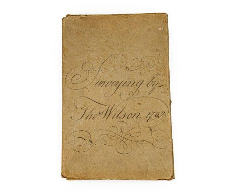
Lot 144
Surveying; Yorkshire. Illustrated manuscript guide to surveying by Thomas Wilson, 1792-3. Folio (330 x 205 mm), contemporary mottled half calf, spine compartments ruled in gilt, paper sides printed with a geometric and floral pattern in red, retaining a contemporary wrapper of heavy wove brown paper with calligraphic manuscript title 'Surveying by Thos. Wilson 1792', edges dyed blue. [84] ff. (laid paper, Britannia watermark), 2 folding estate plans in pen-and-ink and watercolour with decorative cartouches ('A Plan of Part of the Estate of John Jackson Esqr lying in the Parish of Barton' and 'A Plan of Westerdale-Town with some of the Fields Adjoyning'), calligraphic headings, some 80 diagrams and plans in the text, including about 30 simple trigonometric diagrams in pen and ink only, the rest comprising more detailed diagrams and estate plans incorporating stylised features in watercolour including cottages, hedgerows and river courses, calligraphic ownership inscription 'Thos. Wilson's Book 1792' to front free endpaper, a few old stains, in very good condition, unrestored (qty: 1) A remarkable unpublished document produced at the height of the agricultural revolution. Sections include 'Description and Use of Gunter's Chain', 'Practical Surveying by the Theodolite', and 'Irregular Figures to Exercise the Young Surveyor in Casting up'. Provenance: by direct descent to the current vendor.
Lot 124
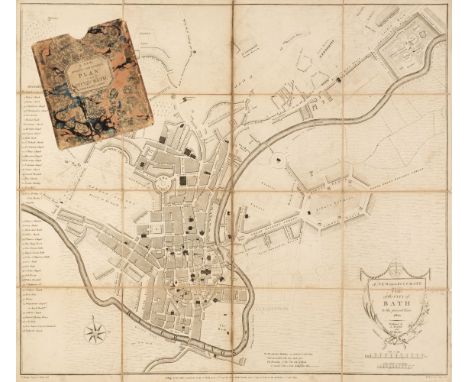
Bath. Chantry (T. Surveyor), A New and Accurate Plan of the City of Bath, A. Taylor & W. Meyler, January 1st. 1801, uncoloured engraved map, sectionalised and laid on linen, key showing 48 places of interest, very slight staining, 465 x 530 mm, contained in a contemporary marbled card slipcase with publisher's printed label to upper cover, slipcase worn and frayed, together with Wright (D.). A Map of the Country round the City of Bath to the Extent of Fifteen Miles and Upwards, C. Goodwin, Sold by the Principal Map and Booksellers in Bath, Bristol & London, June 1st. 1835, uncoloured engraved map, sectionalised and laid on linen, marbled endpapers, 520 x 485 mm, contained in a contemporary marbled card slipcase with publisher's printed label to the upper cover, slipcase worn at extremities, with Greenwood (C. & J. publishers). Untitled Map Sheet of the Environs of Bath & Bristol [1822], engraved map with contemporary outline colouring, sectionalised and laid on linen, a single sheet from the Greenwood large scale map of Somerset, slight offsetting, edged in blue silk, later manuscript ownership signatures and address to verso, marbled endpapers, 475 x 610 mm, contained in a contemporary marbled card slipcase, the slipcase is worn and frayedQty: (3)
Lot 148
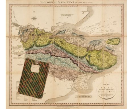
Kent. Cary (John), Geological Map of Kent by W. Smith, Mineral Surveyor, 1819, engraved map with contemporary hand-colouring identifying the various rock strata within the county, sectionalised and laid on linen, additional title within an oval cartouche 'A New Map of Kent Divided into Lathes and Subdivided into Hundreds...,' compass rose and key, slight staining and dust soiling, marbled endpapers with slight wear, 510 x 545 mm, the verso of the marbled endpapers have one ownership paper label of G. M. Arnold Esq. of Milton Hall Gravesend and another of a clipping from an old trade catalogue offering the map for sale for 2s 6d, contained in a contemporary marbled card slipcase, some wear to slipcaseQty: (1)NOTESThe noted cartographer, engraver and publisher John Cary (1755-1835) collaborated with William Smith, 'the father of English geology', on a number of his geological projects, notably the 1815 Map and geological sections (1817-1819). Cary had previously produced large, topographical county maps for his 'New and Correct English Atlas'. The plates that were being prepared for a new edition were instead adapted to accommodate Smith's detailed geology, the first set of geological maps being issued in 1819. This is the first state of these rare geological county maps. The second state, although coloured using William Smith's geology, gives no acknowledgement to Smith at all.
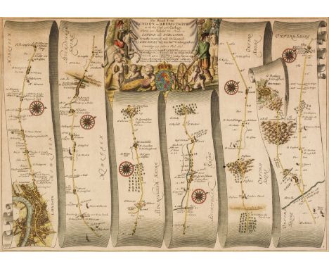
Lot 164
* Ogilby (John). The Road from London to Aberistwith on the Sea coast com. Cardigan, Wherein are included the Roads to Oxford and Worcester Actually Surveyed and Delineated..., circa 1675, Hand-coloured engraved strip road map, decorative cartouche showing a surveyor using a waywiser, 310 x 435 mm, mounted, framed and glazed, together with Carington Bowles (publisher). London to Cirencester and to Glocester by Farringdon, 1785, hand-coloured engraved strip road map, 165 x 95 mm, mounted, framed and glazedQty: (2)NOTESSheet no.1. The road commences at London and passes through Camden, Acton, Hayes, Uxbridge, Beaconsfield, High Wickham, and Tetsworth and ends at Islip, with an inset map to Oxford.
![Pittman (Philip). The Present State of the European Settlements on the Missisippi [sic]; with a geographical description of t](https://cdn.globalauctionplatform.com/10fe502f-d88e-4615-8dd7-ad5900f01de2/05fc8714-5fde-44ab-bafe-ad590110f169/468x382.jpg)
Lot 40
Pittman (Philip). The Present State of the European Settlements on the Missisippi [sic]; with a geographical description of that river. Illustrated by plans and draughts, 1st edition, London: J. Nourse, 1770, [A]4, B-N4, O2, folding engraved frontispiece (plan of New Orleans), half-title, six folding engraved maps & plans by Thomas Kitchen only (of 7, lacking map of the middle section of the Mississippi River, numbered 2 'A Draught of the river Missisippi from the Balise up to Fort Chartres 2' - torn portion present only), occasional offsetting, some dust-soiling mostly to margins, untrimmed and edges largely uncut, bookplate of Napier of Ballikinrain, original publisher's wrappers, loose and somewhat worn, 4to (29 x 22 cm)Qty: (1)NOTESGraff 3302; Howes P396; Sabin 63103; ESTC T105647. This copy includes maps & plans of New Orleans, Fort Rosalia, Mobile, the Iberville River (now Bayou Manchac), the Cascaskies (now Kaskaskia, Illinois), and the Mississippi River (maps 1 & 3 only, lacking map 2 - central portion) commencing at Balise (La Balize, Plaquemines Parish Louisiana) and ending at Fort Chartres (Prairie du Rocher, Randolph county Illinois). Pittman spent five years as a surveyor and military engineer before completing this work. It is an invaluable source for 'the study of early Louisiana history and the western country under British occupation. The plan of Mobile is the earliest known. "The European settlements on the river Mississippi comprehend Louisiana, part of West Florida, and the country of the Illinois. Five years residence as an engineer in those countries, during which time I was chiefly employed in surveying and exploring their interior parts, and an acquaintance with the principal inhabitants enables me to speak with at least as much authority as any author who has hitherto wrote on the same subject." (from the Preface.)

Lot 77
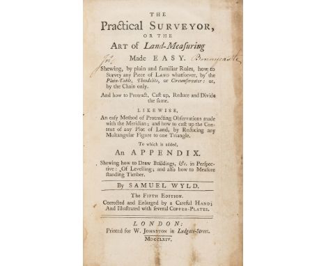
NO RESERVE Wyld (Samuel) The Practical Surveyor, or the Art of Land-Measuring made easy, fifth edition, folding engraved frontispiece and 6 folding plates, previous owner's ink signature to title, spotting, contemporary calf, rebacked, a little rubbed, bumping to corners, 1764 § [Ribright (Thomas)] A Description of the Air-Pump, made in the Form of a Table, first edition, folding engraved plate, lacking pp.17-24 (final 4 leaves), pencil diagrams to plate verso, scattered faint spotting, later paper wrappers, by the maker Thomas Ribright, 1759, 8vo (2)⁂ The last is scarce with only 6 copies on ESTC, 2 in the UK and 4 in the US.
Lot 232
ATTRIBUTED TO JOHN RAPHAEL SMITH (1752-1812). Portrait of a Lady, said to be Hannah More, quarter-length, wearing a white mob cap and brown dress, pastel, oval, 15 x 12 1/2in, sold with a set of eleven volumes of Hannah More's works; together with a volume of 'Letters to a Friend, 1819' (a/f) by James Harrington Evans, the frontispiece with ink inscription, to Mrs Hannah More from the author (J.H.Evans); together with a volume (binding broken) titled 'Memoirs of the Life of Mrs Hannah More'; and an engraving said to depict Hannah More, (the mount bears a label which appears to by inscribed by Hannah More). Also included in the lot is a pen and ink 'Plan of the Parish of Croscombe in the County of Somerset' by B. Tuthill, Surveyor, 1809; together with a book titled the 'Village of Croscombe' by the Rev. John East, printed by J. Chillcott, Bristol, 1831. Hannah More (1745-1833) was a noted literary figure, educator and anti-slavery figure, and one of the most influential female philanthropists of her day
Lot 30
The Complete Surveyor Containing the Whole Art of Surveying of Land.. William Leybourn The Third Edition corrected and enlarged 1674. A rare title with two plates replaced in facimile and a third at page 61 with some loss, neatly repaired in handsome Half leather binding and with raised bands to spine together with a small collection of mainly surveying titles ie Hudson's land values Assistant etc. (6 titles in all)
Lot 105
WYLD (SAMUEL)The Practical Surveyor, or, the Art of Land-Measuring, Made Easy, FIRST EDITION, engraved folding frontispiece and 5 plates (one with short tear), some spotting, contemporary calf, rebacked in calf gilt, upper cover near detached, J. Hooke and J. Sisson, 1725; idem, second edition 'Corrected and enlarged by a careful hand', engraved folding frontispiece and 6 plates (2 shaved touching lettering), light dampstaining to frontispiece, contemporary panelled calf, red morocco spine label, joints weakened, H. Lintot, [1730?]; idem, fourth edition, engraved folding frontispiece and 6 plates, contemporary calf, worn, joints weakened, W. Johnston, 1760--DAVIS (WILLIAM) A Treatise on Land Surveying, fifth edition, engraved frontispiece portrait, 9 folding engraved plates, some off-setting and spotting, contemporary half calf over marbled boards, joints weakened, Anne Davis, 1813, 8vo (4)This lot is subject to the following lot symbols: •• Zero rated for VAT, no VAT will be added to the Hammer Price or the Buyer's Premium.For further information on this lot please visit Bonhams.com

Lot 28
SECOND ANGLO-AFGHAN WAR 1878-1881Papers of Lieutenant Colonel Hardin Burnley-Campbell (1843-1920) of the 6th Dragoon Guards (Carabiniers), relating to his service in India during the second Afghan Campaign of 1878-1881, comprising:i) Two army regimental order books for 'Troop B', written in ink in several hands, volume one detailing daily orders from 17 September to 28 November 1879, volume two continuing until 23 March 1880, mostly covering the minutiae of camp life such as the daily timetable ('...Reveille 6.30, Stables 7...'), parades and inspections, court martials, lists of men and support staff ('...grass cutters... native farriers... cooks...'), the care and exercising of horses ('...Horses heels will be thoroughly dried with rubbers...'), uniform ('...the kharki jacket to be worn over the patrol jacket... 2 pairs of cloth pantaloons if possible...'), equipment ('...owing to the destruction of saddlery &c by white ants in future the saddles will be placed on a portion of the hoop grass in piles of 6...'), ammunition ('...any man losing it will be severely delt with...'), welfare of the men ('...All men off duty will... be marched to the left bank of the Cabul River for bathing...'), preparations to move camp ('...not more than 3 horses length distance to be between each troop...'), the troops ready for action ('...After orders by Capt. Burnley. Every Man will sleep tonight with his cloak Belts & Arms on ready to turn out at a moments notice...'), including mention of their involvement at the Battle of Gara Heights at Dakka on 15 January 1880 ('...The Commanding Officer begs to thank most heartily the Officers and men... for their steady and soldier like bearing when exposed to the fire of the enemy this day... the patrol and scouting duties (the later especially) were entirely carried out to his satisfaction, likewise the dismounted skirmishing...'), final entries reversed, c.470pp, some pages excised, 'Bengal Form 358' notebooks, original calf with printed paper labels ('Order Book'), brass clasps (broken), worn with some ink stains, oblong 4to (120 x 180mm.), Umballa, Camp Basawal, Camp Jellalabad, September 1879 to March 1880ii) Group of six autograph letters signed ('Hardin Burnley') to his father ('My dear Father'), the first commenting on bad news from the Cape ('...if we do not learn a lesson now... Afghanistan may furnish us with a like tale...') and that they must not underestimate the natives' fighting capabilities, with envelope; the second in pencil describing escorting the deposed Emir, Mohammad Yaqub Khan into exile in December 1879 ('...with my squadron 80 men & 4 officers... he only halted 20 minutes... sitting on a chair with his attendants on the road side – I got aides to ride on his right hand side all the way... this I did for 2 days – He was most communicative and chatted on all topics freely... no attack was made on us – all well... most shocking dust storm... carrying away some tents & nearly suffocating everyone...'); the next reporting on '...serious fighting Kabul way...', that they will soon have to relieve the 9th Lancers, skirmishes with locals ('...met with no resistance... otherwise the guns were in position... & would have shelled the village at once...'), believing they will be 'in this inhospitable' country for the long haul, talking of disease and casualties ('...considering this is but Guerrilla warfare.. it is grand training...'), and asking if he received the tiger and panther skins; one written 6 August 1880 on the eve of joining General Gough as his ADC on the Kandahar march ('...I leave here tomorrow... If the Afghans get hold of me I wish you to send to my servant... £50... I have given him this letter to give to you if anything should happen to me...'); another expressing pleasure at receiving two medals and clasps, talking of parties, shooting and other entertainments, with envelope; the last on social engagements in London, 41 pages, 8vo (180 x 114mm.), Umballa, Basawal, Cabul, Naval & Military Club, Piccadilly, 13 February 1879 to [23 May 1881] iii) Three autograph letters from General Sir Hugh Gough signed ('Hugh Gough'), reminiscing '...I hope you have not forgotten our old days on the Kabul Kandahar March. I look back to them with much pleasure and can never forget the best ADC I ever had – I wish I could have more of my old soldiering days over again...'; one thanking him for the grouse; each with envelope, 8 pages, 8vo (150 x 95mm.), Canterbury, August [18]93; one other earlier letter, undated iv) Other papers, including pocket almanack for 1878 containing troop and staff rolls, with pencilled notes on orders, rates of pay, bets with other officers, notable skirmishes ('...the attack on village near Peswar took place early morning of 6th July. Rpt 2 squadrons got up too late...'), rations ('...1 lb Bread & Biscuit/ 1 dram of rum...') etc., c.60 pages, some pages roughly excised, calf with broken brass clasp and integral pencil, small 8vo; official request from Burnley to Lieut. Col. John Fryer, commanding the Carabiniers at Simla that he should be '...employed on active service with any expeditionary force that may be deployed to the Frontier...', one page, folio (332 x 208mm.), Umballa, 25 September 1878; portrait cabinet photograph of a young Burnley in civilian dress; various loose notes, incoming correspondence, etc. including a typed biography annotated 'Some incidents of my life'v) The Khandahar Pantomime Ayoub Khan. Written and composed by Mr F. C. Keyser and now printed by special request, original blue mottled paper wrappers, 8vo (180 x 105mm.), Poona, Printed at the Orphanage Press, 1884; two folding maps printed on linen: 'Afghan'... Enlarged at the Survey Office in Dehra Dun October 1878, 870 x 655mm., annotated in ink by Burnley; and 'Istan' by Col. J. T. Walker, Surveyor General of India, 890 x 655mm., with routes marked in red crayonFootnotes:Lieutenant Colonel Hardin Burnley-Campbell (1843-1920) was gazetted Cornet in the 6th Dragoon Guards (Carabiniers) in 1865. After several years in Ireland, he was posted to the Umballa station in India in 1878 where duties consisted of escort and transport tasks along the Khyber lines of communication. Whilst commanding a squadron at Basowal, following the murder of the political agent Cavagnari and the failure of the Treaty of Gandamak, he was charged with accompanying the deposed Emir Yaqub Khan into exile in India. He was present at the affair at Dakka on 15 January 1880, as mentioned in our notebook, before rejoining the Headquarters of the Regiment at Jellalabad. In August 1880 he was appointed Orderly Officer to the Cavalry Brigadier, General Sir Hugh Gough and with the Cavalry Brigade accompanied Lt. General Sir Frederick Roberts on his famous, impressively fast, march from Kabul to Kandahar, and was present at the battle of Kandahar on 1st September. He was the only member of the regiment to receive a bronze star for this epic journey and was mentioned in despatches.After the Afghan campaign, Major Burnley saw service in the first Boer campaign (see lot 13) and retired in 1882, receiving the honorary rank of Lieutenant Colonel in consideration of his distinguished service during the Afghan War. In June 1907 he became a real-life Phileas Fogg by circumnavigating the globe in 40 days, 19 hours and 30 minutes, breaking the previous record of 54 days, a record which he held for four years. His papers have been in the possession of his family until now.For further information on this lot please visit Bonhams.com
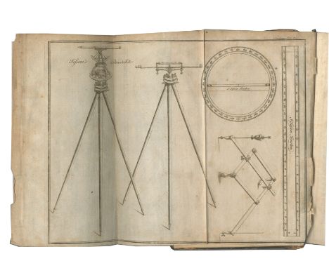
Lot 76
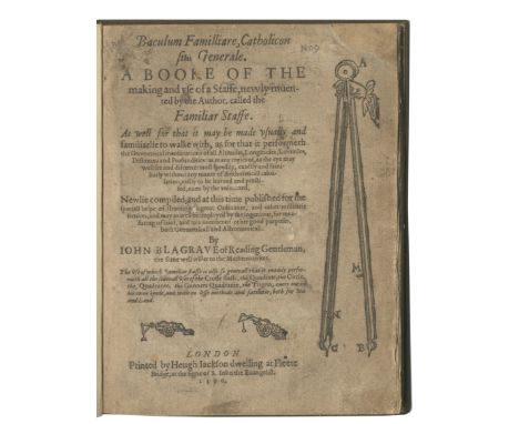
BLAGRAVE (JOHN)Baculum Familliare, Catholicon sive Generale. A Booke of the Making and Use of a Staffe, Newly Invented by the Author, Called the Familiar Staffe, FIRST EDITION, black letter, woodcut illustrations on title and several text leaves, woodcut initials and decorations, with final blank (K4), title soiled with small hole (filled touching 3 letters, and one corner repaired), a few short marginal repairs, one ornament shaved, modern cloth [ESTC S102659], small 4to (184 x 140mm.), Printed by Heugh Jackson, 1590Footnotes:First edition of a work by the practical mathematician John Blagrave (c.1561-1611), who practised as a land surveyor and designed and made scientific instruments, including an astrolabe, described in his The Mathematical Jewel (1585). Between 1589 and 1596 he enjoyed the patronage of Sir Francis Knolles, the dedicatee of Baculum familliare which describes a 'familiare staffe', an early example of an elaborate universal instrument, which the author claimed 'readily performeth all the severall uses of the Crosse Staff, the Quadrate, the Circle, the Quadrante, the Gunners Quadrante, [and] the Trigon', for use in surveying, ordnance and military practices.Provenance: Lawes Agricultural Trust, stamp inside upper cover.This lot is subject to the following lot symbols: •• Zero rated for VAT, no VAT will be added to the Hammer Price or the Buyer's Premium.For further information on this lot please visit Bonhams.com
![C[HURCHE] R[OOKE])An Olde Thrift Newly Revived. Wherein is Declared the Manner of Planting, Preserving, and Husbanding Yong T](https://cdn.globalauctionplatform.com/5329f428-b57e-403c-aeba-ad3b00cf838d/2648370c-d4f3-42a4-bf2b-ad4a00adb94e/468x382.jpg)
Lot 78
C[HURCHE] R[OOKE])An Olde Thrift Newly Revived. Wherein is Declared the Manner of Planting, Preserving, and Husbanding Yong Trees of Divers Kindes for Timber and Fuell. And of Sowing Acornes, Chesnuts, Beech-mas, the Seedes of Elmes, Ashen-keys, &c... And Also the Use of a Small Portable Instrument for Measuring of Board, and the Solid Content and Height of any Tree Standing... Discoursed in Dialogue betweene a Surveyour, Woodward, Gentleman, and a Farmer, FIRST EDITION, black letter, one folding woodcut plate of an instrument, several diagrams in the text, woodcut decorations and initials, without blank A1, shaved touching letters of running headline or side-notes on 18 pages, light soiling to title, twentieth century polished calf gilt, gilt morocco spine labels, g.e., one joint slightly rubbed [ESTC S107648, listing 3 variants, this with wording '.. odious to Farmers' of line 21 on D3r; Henrey 29; not in Goldsmiths or Kress], small 4to (175 x 132mm.), Printed by W.S. for Richard Moore, 1612Footnotes:'... for doe we think that wood alone can beare the brunt to satisfie every mans chimney? assuredly no, except it were more plentifull' (Preface). Written in the form of a dialogue between a surveyor, woodsman, gentleman and farmer, the work debates the problem of the rapid disappearance of England's forests. The author, himself a surveyor, advocated the use of enclosures. The final part is devoted to a measuring instrument, usable by those with 'any understanding in the science of Arithmeticke'.Provenance: Lawes Agricultural Trust, ownership inscription.This lot is subject to the following lot symbols: •• Zero rated for VAT, no VAT will be added to the Hammer Price or the Buyer's Premium.For further information on this lot please visit Bonhams.com
![[LEYBOURN (WILLIAM)]Planometria: or the Whole Art of Surveying of Land: Shewing the Composition, and Use of All the Most Nece](https://cdn.globalauctionplatform.com/5329f428-b57e-403c-aeba-ad3b00cf838d/9a7c6707-bac4-4b80-b839-ad4a00ae0996/468x382.jpg)
Lot 94
[LEYBOURN (WILLIAM)]Planometria: or the Whole Art of Surveying of Land: Shewing the Composition, and Use of All the Most Necessary Instruments thereunto Belonging... by Oliver Wallinby, FIRST EDITION, first leaf bears signature mark 'A' within ornamental border on recto and illustration on verso, woodcut illustrations and diagrams (with large diagram cut to size and laid down on C1 as instructed), mathematical calculations in an early hand to front free endpaper, contemporary sheep, rubbed, small loss to head of spine [ESTC R42121], 8vo, Printed for Nathanael Brooks, 1650Footnotes:Rare first edition of Leybourn's influential treatise on surveying, published under the pseudonym Oliver Wallinby (an anagram of his name), which was enlarged and printed as The Compleat Surveyor three years later.Provenance: Ch. Hevingham, ?eighteenth century inscription on title-page; Rothamsted Experimental Station, stamp inside upper cover.This lot is subject to the following lot symbols: •• Zero rated for VAT, no VAT will be added to the Hammer Price or the Buyer's Premium.For further information on this lot please visit Bonhams.com
Lot 95
LEYBOURN (WILLIAM)The Compleat Surveyor: Containing the Whole Art of Surveying of Land, by the Plain Table, Theodolite, Circumferentor, and Peractor... With Whatsoever Else is Necessary to the Art of Surveying, engraved frontispiece portrait of the author (aged 27), title printed in red and black within typographic border, diagrams in the text, woodcut ornaments and decorative initials, small circular hole cut from margin of pp.57/58 touching printed rule border, a few small rustholes (touching letters on pp.52/54, and pp. 75/76), ink smudges on p.68, some spotting and a few small ink marks elsewhere, contemporary calf, worn with small losses at corners and foot of spine, upper hinge cracked [ESTC R20856], small folio (280 x 185mm.), R. & W. Leybourn, for E. Brewster, 1653Footnotes:Scarce at auction, the expanded version of William Leybourn's influential treatise on surveying. First published anonymously as a pamphlet titled Planometria, or, The Whole Art of Surveying of Land in 1650, there were four further editions published in the author's lifetime. Leybourn (1626-1716) was subsequently 'appointed one of the six surveyors to measure the damage caused by the Great Fire of London.... [and his] practice as a land surveyor continued and he mapped estates in London and many other English counties' (ODNB).Provenance: Anthony Methwin, several ink inscriptions to endpapers and blank recto of frontispiece, one dated 1669; Lawes Agricultural Trust, stamp inside upper cover.This lot is subject to the following lot symbols: •• Zero rated for VAT, no VAT will be added to the Hammer Price or the Buyer's Premium.For further information on this lot please visit Bonhams.com
![N[ORDEN] (J[OHN)]The Surveyors Dialogue... Very Profitable for All Men to Peruse, that Have to Do with Revenues of Land, or t](https://cdn.globalauctionplatform.com/5329f428-b57e-403c-aeba-ad3b00cf838d/aca56b81-cf92-437f-a784-ad4a00ae1605/468x382.jpg)
Lot 96
N[ORDEN] (J[OHN)]The Surveyors Dialogue... Very Profitable for All Men to Peruse, that Have to Do with Revenues of Land, or the Manurance, Use, or Occupation Thereof, Both Lords and Tenants, FIRST EDITION, initial blank with signature-mark 'A' (with several early ink scribblings, laid down), woodcut ornament on title, several diagrams in the text, without final 2 blanks, good margins, a few small neat marginal repairs, modern red morocco, early vellum covers and spine bound in at end [ESTC S113314; Kress 279], small 4to (190 x 138mm.), Printed [by Simon Stafford] for Hugh Astley, 1607Footnotes:First edition of the first English surveying publication of the seventeenth century, 'important because of Norden's clear account of the operation of the court of survey and because of his efforts to reconcile the differences between surveyor and tenant' (A.W. Richeson, English Land Measuring to 1800, 1966).Provenance: Lawes Agricultural Library, stamp inside upper cover.This lot is subject to the following lot symbols: •• Zero rated for VAT, no VAT will be added to the Hammer Price or the Buyer's Premium.For further information on this lot please visit Bonhams.com
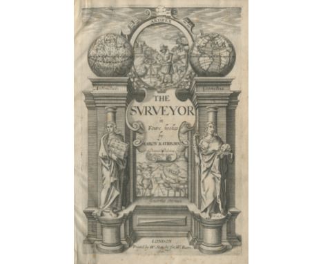
Lot 98
RATHBORNE (AARON)The Surveyor in Foure Bookes, FIRST EDITION, engraved allegorical title-page, 2 engraved portraits (that of the author cut to size and mounted as frontispiece; the other of Prince Charles, Prince of Wales), woodcut illustrations and diagrams in the text, woodcut ornaments and decorative initials, without final 2 blanks, occasional light marginal water-staining, a few spots and marks, later calf, spine gilt in compartments, joints slightly weakened [ESTC S116149; Fussell I, pp.22-23], small folio (270 x 180mm.), W. Stansby for W. Burre, 1616Footnotes:First edition of Rathborne's The Surveyor, an 'influential textbook addressed the practical everyday needs of surveyors more realistically than had been done hitherto' (ODNB), and written in the vernacular. Rathborne placed surveying firmly among the mathematical sciences, drawing on the latest teaching given at Gresham College, notably Henry Brigg's lectures on logarithms.This lot is subject to the following lot symbols: •• Zero rated for VAT, no VAT will be added to the Hammer Price or the Buyer's Premium.For further information on this lot please visit Bonhams.com
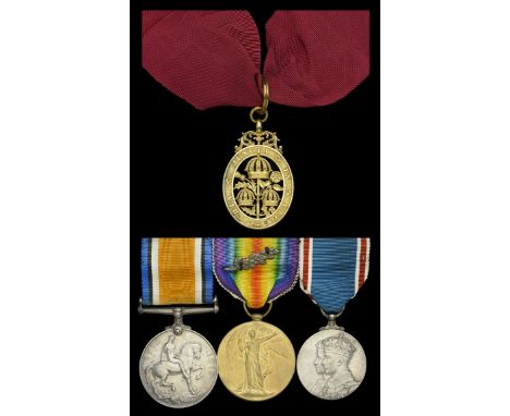
Lot 29
An inter-War ‘Civil Division’ C.B. group of four awarded to T. H. Boyd Esq., Assistant Director-General, Post Office, late Captain, Royal Naval Air Service and Royal Air Force, who was Mentioned in Despatches for sinking a German submarine in March 1918 The Most Honourable Order of the Bath, C.B. (Civil) Companion’s breast badge, converted for neck wear, silver-gilt, hallmarks for London 1903, with neck riband; British War and Victory Medals, with M.I.D. oak leaves (Capt. T. H. Boyd. R.A.F.); Coronation 1937, unnamed as issued, mounted as worn, very fine (4) £600-£800 --- C.B. London Gazette 1 January 1938. Thomas Herbert Boyd was born in 1890 and was educated at London University. He was employed pre-War as an Assistant-Surveyor, General Post Office, and was appointed a Probationary Flight Officer, Royal Naval Air Service, on 22 October 1916. He was appointed Flight Sub-Lieutenant at Calshot Naval Air Station in July 1917, and was posted to H.M.S. Campania in October of that year. He transferred to the Royal Air Force as an Aeroplane and Seaplane Pilot in April 1918, and served as Acting Flight Commander, H.M.S. Campania, from September 1918. For his services during the Great War he was Mentioned in Despatches (London Gazette 3 June 1918) - his Times obituary states that this was specifically for the sinking of an enemy submarine in March 1918. He transferred to the Unemployed List with the rank of Captain in May 1919. Resuming his career with the General Post Office, Boyd held numerous senior positions, culminating in his appointment as Assistant Director-General on 18 August 1936, on an annual salary of £2,000. Appointed a Companion of the Order of the Bath in the 1938 New Year’s Honours’ List, he died on 28 May 1941. Sold with copied research.
Lot 7
WHITE CAPTAIN T. P. Album of Original Drawings. 46 pen & ink sketches & drawings, one or two coloured, some monogrammed & mainly captioned. Laid onto 28 thick paper sheets (one-side only with one exception). Quarto. Well worn bdg., c.1870's. White was a surveyor employed by the Ordnance Survey. He published folio vols. on the archaeological remains of Kintyre, Knapdale & Gigha (see previous lot 6). Some of these drawings appear in these works but others are unpublished. A good example of a 19th century artist's / archaeologist's working sketch book.
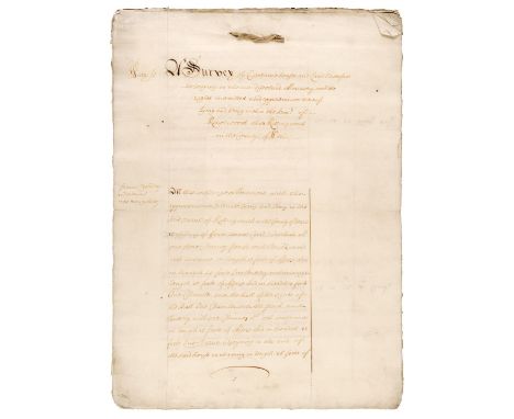
Lot 173
* Warwickshire. A survey of Certaine houses and Land heretofore belonging to the late dissolved Monastery with the rights members and appurtenances thereof lying and being within Kenelworth alias Killingworth in the County of Warrwickshire, entered 12 August 1650, contemporary manuscript fair copy on rectos of 16 laid paper leaves, property owner names include Francis Yardley (now Mary Yardley), Elizabeth Grainer, John Norton, Martha Phipps, Zachary Taylor, with an abstract at end for the Earls of Monmouth, and the name William Webb as Surveyor General, a little soiling and closed tear to final leaf with old tape repairs to verso, final leaf verso a little frayed and soiled, tied at upper margin, 43 x 31 cmQty: (1)
-
1532 item(s)/page