

Admiral Lord Nelson interest - A Wedgwood creamware sauce tureen possibly bearing the cipher of the Duke of Brontë the tureen c.1800, with twin bifurcated handles and lobed cover with urn finial, lobed pedestal foot, dark brown painted husk decoration, the cover and base also painted with a feathered letter `B` below a ducal coronet, 5½in. (14cm.) high, a/f; together with a set of five late 18th century style Wedgwood chocolate or custard cups and covers, early 20th century, with angular handles and pedestal feet, the domed covers with spire finials, decorated with gilded foliate borders and lining, impressed `Wedgwood` and printed `Goode` retailer`s stamp, 3¾in. (9.5cm.) high, four a/f; and their matching elongated octagonal tray, impressed `Wedgwood 3XO`, 13in. (33cm.) long. (13) * From the collection of a descendant of Sir Robert Seppings, senior naval architect, Master Shipwright at Chatham from 1804 and Surveyor of the British Navy from 1813. This small collection of late 18th century Wedgwood was, by family repute, gifted to Seppings by Nelson, the `B` cipher on the tureen attributed to the title `Duke of Bronté`, given to Nelson by Ferdinand IV of Naples and Sicily in 1801. ** Please see a Sheffield Plate vegetable tureen, c.1801, sold by Sotheby`s on 29th November 2005, Important Silver, Gold Boxes & Objects of Vertu, Lot 86, which is engraved with a very similar `B` below a ducal coronet cipher, sold with definite provenance from Admiral Lord Nelson.
We found 1532 price guide item(s) matching your search
There are 1532 lots that match your search criteria. Subscribe now to get instant access to the full price guide service.
Click here to subscribe- List
- Grid
-
1532 item(s)/page

Plan of the Town and Parish of St. Peter Port, Guernsey `Surveyed and Drawn by James Duquemin, Surveyor to the States of Guernsey, Published for the Proprietor by F. Clarke, States Arcade, Guernsey, 1873`, scale 400ft. to 1in., with hand colouring, 26½ x 36¼in. (67.5 x 92cm.), framed and glazed. See Illustration


19th Century brass 360˚ protractor by A. Holmes of London, 15.5cm diameter, in a mahogany case together with a late 19th Century boxwood and brass surveyor’s sector rule (compass missing), 16.5cm long when closed, in a stitched leather case The protractor case hinged cover broken through with mosses to the wood, the protractor with signs of tarnish, the rule case stained and torn near the hinge and compass missing as mentioned in description - ** General condition consistent with age


Scale, Bernard. An Hibernian Atlas; or General Description of the Kingdom of Ireland: Divided Into Provinces.... ....with Its Sub-Divisions of Counties, Baronies &c.. London: Laurie & Whittle, 1776. First Edition. 4to. Hard Cover. Very Good Shewing their Boundaries, Extent, Soil, Produce, Contents, Measure, Members of Parliament, and Numbers of Inhabitants; also the Cities, Boroughs, Villages; Mountains, Bogs, Lakes, Rivers and Natural Curiosities Together with the Great and Bye Post Roads. The Whole taken from actual Surveys and Observations by Bernard Scale, Land Surveyor and beautifully engraved on 78 Copper Plates by Messrs. Ellis and Palmer. Engraved title and dedication page and 37 full page hand-coloured maps including map of Ireland, a map of each of the four Provinces of Leinster, Munster, Ulster and Connaught and a map of each of the 32 counties of Ireland. Full calf. Professionally rebacked with decorative gilt spine & title on red label. Previous owner`s bookplate on front pastedown. This is the rare first edition.

ABRAHAM DE SMIDT (SOUTH AFRICAN, 1829-1908) Tintagel, Cornwall Pencil and watercolour heightened with white, signed, titled and dated 1898 lower left, 25 x 35cm De Smidt was a life long Cape Colony civil servant becoming Surveyor-General in 1873, a keen artist and a founding member of the South African Fine Art Association. At retirement in 1889 he moved to England where he resided until his death in 1908
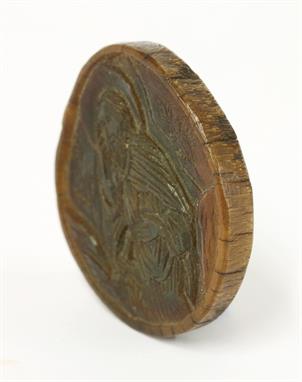
A carved rhinoceros horn disc, possibly 17th century, carved with an image of Christ, with paper label '72- No.120 Rec'd Oct '80 - On loan from Wm Bragge, Esq.', 5cm diameter 7mm deep William Bragge (1823-84), engineer and antiquary, was born in Birmingham, son of Thomas Perry Bragge, jeweller. He trained as a railway surveyor and engineer, supervised the Chester to Holyhead line and carried out railway and lighting projects in Brazil. From 1858-72, he was a managing director of John Brown and Co., an armour-plate manufacturers in Sheffield, becoming Master Cutler and Mayor of Sheffield. He left for Paris in 1872 to try to develop a sewage system but, unsuccessful, he returned to Birmingham in 1876 to establish a watch-making factory. A great collector, he donated his 1,500 volume collection of works by or relating to Cervantes to the Birmingham Free Libraries in 1873, unfortunately destroyed by the fire there in 1879. CITES PRE-SALE APPROVAL HAS BEEN GRANTED, BUT AN EXPORT LICENCE IS UNLIKELY TO BE ISSUED. CONDITION REPORT: 15.7g size - 5cm diameter. 7mm deep


Crevecoeur, Michel Guillaume De 1787 Carte Generale des Etats-Unis de l`Amerique Septentrionale, Renfermant Aussi Quelques Provinces Angloises Adjacentes... ""An uncommon map of the early United States and the first printed map to name Frankland. Also known as Franklinia, it is shown here just west of the border of North Carolina, named Pays de Frankland. In 1785 settlers in western North Carolina and what would become eastern Tennessee organized a state government to be named in honor of Benjamin Franklin. Congress turned down their appeal but the state maintained a legislature and governor until 1788. This ephemeral state appears on only a small number of maps. The 14th state of Vermont is named and noted in the key at right, with a notation in French that it was """"not yet accepted in the confederation."""" Virginia is shown in a strange configuration and there is a square-shaped region denoted as Pays de Kentukey. Engraved by Pierre Francois Tardieu. Crevecoeur was a French-born surveyor who settled in New York, where he produced this classic collection of twelve essays that reflected on the nature of American life, particularly its customs and manners. His description of bountiful American lands spurred many French people to immigrate to America. Howes says that Crevecoeur`s work is a: """"Description of American life of great influence in attracting European immigration in the post-revolutionary period. As literature unexcelled by any American work of the eighteenth century."""" See also Lot 178 for Crevecoeur`s three-volume Lettres d`un Cultivateur Ameriquain."" 16.7"" W x 10.1"" H Issued folding on watermarked paper with a short fold separation that just enters the image at right, some minor offsetting, and a binding trim at right.

U.S. Government, 1837 A Plat Exhibiting the State of the Surveys in the Territory of Florida This map is one of the earliest to illustrate the status of public land surveys in the Eastern Land District (east of the Suwanee River) and the Western Land District (west of the Suwanee) in the Florida Panhandle. Survey efforts south of the Indian Boundary Line (marked in red/pink) in southern Florida were largely suspended due to the guerilla warfare of the ongoing Second Seminole War. St. Augustine, Amelia Island, and Tallahassee are named. In this early edition, the supposed boundary of the Forbes Purchase is uncolored and the legend notes that its limits are undefined. From the Surveyors Office in Tallahassee by Robert Butler, Surveyor General for the Territory of Florida. A very early edition of this chart. 23"" W x 8.4"" H Issued folding with a few short fold separations confined to the blank margins that have been closed on verso with archival materials and some minor toning, mostly along the sheet`s edges and folds.
![Crevecoeur, Michel Guillaume De 1787 Esquisse du Muskinghum [on sheet with] Esquisse du Sioto [and] Esquisse de la Riviere d](http://lot-images.atgmedia.com/SR/36385/2901770/297-201425154217_468x382.jpg)
Crevecoeur, Michel Guillaume De 1787 Esquisse du Muskinghum [on sheet with] Esquisse du Sioto [and] Esquisse de la Riviere du Grand Castor ""Interesting map from a French edition of Crevecoeur`s important early collection of essays (Letters from an American Farmer). The sheet contains three separate maps showing the Indian villages in the region of the Ohio River. Engraved by Pierre Francois Tardieu. At upper left above neatline is """"Tome IIIme. Page 413."""" Crevecoeur was a French-born surveyor who settled in New York, where he produced this classic collection of twelve essays that reflected on the nature of American life, particularly its customs and manners. His description of bountiful American lands spurred many French people to immigrate to America. Howes describes Crevecoeur`s work as follows: """"Description of American life of great influence in attracting European immigration in the post-revolutionary period. As literature unexcelled by any American work of the eighteenth century."""" See also Lot 178 for Crevecoeur`s three-volume Lettres d`un Cultivateur Ameriquain."" 20.4"" W x 9.3"" H Issued folding on thick hand-laid watermarked paper with some light offsetting.

An early heavy cast iron railway bridge notice, inscribed 'Take notice this bridge is insufficient to carry weights beyond the ordinary traffic and owners and persons in charge of locomotives and other carriages of great weight are warned against attempting to pass over the bridge. By Order of Quarter Sessions. J George Powell County Surveyor of Wiltshire. NB. The latter name appears to have been added later suggesting an earlier surveyors name below.

(x) South West AfricaSouth African Stamps used in South West AfricaCollection on pages, over 100 stamps with values to 5/- (pair) and 10/-, cancellations with Ar Oab, Aus Rail, Bethany, Brackwasser, Gibeon, Grootfontein, Guchab, Hatsamas, Kalkfeld Rail, Kalkveld, Keetmanshoop, Komanskop, Kur, Kurbis, Leutwein Rail, Luderitz, Luderitzbucht, Malatahohe, Maltaho, Mariental, Neuheusis, Okandja, Okasise Rail, Otavi, Otjiwrongo, Outjo, Rehoboth, Swakopmund, Usakos, Walvis Bay, Warmbad, Windhoek, Windhuk, etc., many complete postmarks on pieces, also Revenue 5/-, 10/-, £1 and £2 on piece with oval "surveyor general/windhoek"; chiefly good to fine Subject to 5% tax on Hammer Price in addition to 20% VAT on Buyer’s Premium. For more information please view Terms and Conditions for Buyers.


Admiral Lord Nelson interest - a facsimile letter from Nelson to his daughter Horatia 19th century, dated `Victory Oct. 19th: 1805`, stating that `...I rejoice to hear that you are so very good a girl and love my Dear Lady Hamilton who most dearly loves you, give her a kiss for me........I shall be sure of your prayers for my safety, conquest and speedy return to Dear Merton and our Dearest Good Lady Hamilton` and signed `Nelson Bronte`, printed on laid paper and folded, 9½ x 7¾in., (24 x 19.5cm.). * From the collection of a descendant of Sir Robert Seppings, senior naval architect, Master Shipwright at Chatham from 1804 and Surveyor of the British Navy from 1813. Accompanied by a letter from the Curator of The British Library, dated Fe. 13th 1990, advising that they have a copy in their collection and that the facsimile letters were possibly printed to assist in raising funds for Horatia Nelson after Admiral Nelson`s death.

Jeppe, Friedrich Map of Zoutpansberg 341mm x 428mm `Schets Kaart Aantoonende de Zoutpansberg Goudvelden Gekompileerd van Metingen en Inspectien Door Fred. Jeppe Landmeter Generaals Departement Februari 1893.``Schaal 4000 Kaapsche Roeden op 1 Duim. Shaal 9;39 Engelsche Miljen op 1 Duim (Inch).`This map has recently been the subject of research. Its relevance today has to do with land claims and mineral rights in the Zoutpansberg, and how colonial authorities acted in the interests of the mining houses rather than the indigenous people of the ZoutpansbergCONDITION DETAILS: Images have been provided of some of the marks on the rear of the map. The tear at the bottom edge is also pictured, front and rear views. A close up of the right hand side margin shows the darkening around the entire margin caused by a mount for the many years that this map was in a frame, and two short closed tears. The back of the map is also darkened. This map has no fold marks. Good Pretoria Z.A.R. Surveyor General`s Office 1893 - February Reserve: $80 Click here to view further details and to bid

Crevecoeur, Michel Guillaume De 1787 Carte de l`Ile de Nantucket, pour les Lettres d’un Cultivateur Ameriquain "This early copper engraved map of Nantucket includes a legend identifying thirty-two different sites. In addition to the detail in the legend, the map locates Sherburn, Full Mill and “Isle de Tuckanuck”. Engraved by Pierre Francois Tardieu. Crevecoeur was a French-born surveyor who settled in New York, where he produced this classic collection of twelve essays that reflected on the nature of American life, particularly its customs and manners. His description of bountiful American lands spurred many French people to immigrate to America. Howes says that Crevecoeur`s work is a: “Description of American life of great influence in attracting European immigration in the post-revolutionary period. As literature unexcelled by any American work of the eighteenth century.” 11" W x 8" H Issued folding on watermarked paper with a few minor spots and light soiling along the sheet edges.
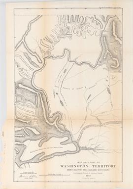
Tilton, James 1857 Map of a Part of Washington Territory Lying East of the Cascade Mountains to Accompany Report of Surveyor General This uncommon and very detailed map covers the Columbia River from Ft. Dallas eastward to Ft. Walla-Walla, and north to Ft. Colvill. The "Great Plateau of Spokane" spans the center of the map. In the upper right corner the "Gold Mines" are shown along the "Western limits of the Rock Mountains". Steven`s survey route for the Pacific Railroad, creeks, rivers, lakes, roads, the Old Presbyterian Mission are also shown. The map was surveyed by Tilton and lithographed by C.B. Graham, Washington D.C., 1857. 14" W x 22.1" H A nice, dark impression, issued folding, with minor toning and numerous fold separations backed in Japanese tissue on verso.
![Blaeu, Johannes 1654 [Lot of 2] Caricta Borealis vulgo the Northpart of Carrick [and] Carricta Meridionalis / The South Part](http://lot-images.atgmedia.com/SR/36385/2893812/414-2013117142119_468x382.jpg)
Blaeu, Johannes 1654 [Lot of 2] Caricta Borealis vulgo the Northpart of Carrick [and] Carricta Meridionalis / The South Part of Carrick "This pair of finely engraved maps depict the historic region of Carrick, now part of South Ayrshire. The maps, based on the work of Timothy Pont, famous surveyor of Scotland in the late sixteenth century, include great detail of the rivers, cities, villages and castles. The city of Ayr appears at the top of the northern sheet. Each map features an elaborate title cartouche and scale of miles cartouche, illustrated with regional figures and putti. Latin text on verso of the southern sheet only. A. “Caricta Borealis vulgo the Northpart of Carrick” (20.7 x 16.5”). Condition: Attractive color and wide margins with a hint of offsetting and a bit of printer`s ink residue. (A) B. “Carricta Meridionalis / The South Part of Carrick” (20.7 x 15.1”). Condition: Attractive color and wide margins with light offsetting and some show-through of text on verso. (B+)" #VALUE! See description.

Blaeu, Johannes 1654 Cantyra Chersonesus, Cantyr a Demie-yland This finely engraved map depicts the peninsula of Kintyre within Argyll and Bute, with north oriented to the right. The map, based on the work of Timothy Pont, famous surveyor of Scotland in the late sixteenth century, includes great detail of the rivers, villages and castles. An elaborate title cartouche and scale of miles cartouche decorate the map, both illustrated with putti. Latin text on verso. 19.6" W x 16.3" H Attractive color and wide margins with light offsetting and some show-through of text on verso.

Blaeu, Johannes 1654 Knapdalia Provincia, que sub Argathelia Censetur / The Province of Knapdail which is Accounted a Member of Argyll This finely engraved map depicts Knapdale, a rural district of Argyll and Bute in the Scottish Highlands, just west of Loch Fyne. The map, based on the work of Timothy Pont, famous surveyor of Scotland in the late sixteenth century, includes great detail of the rivers, cities, villages and castles. An elaborate title cartouche decorates the map, illustrated with putti, sea monsters and mer-people. Latin text on verso. 21" W x 16.6" H Attractive color and wide margins with light offsetting and some show-through of text on verso.

Blaeu, (Family) 1640 Natolia, quae olim Asia Minor This handsome map of present-day Turkey includes several Aegean Islands and Cyprus prominently shown in the south. A fierce sea battle rages in the Mediterranean along with curious looking sea monsters. Two winged female creatures suspend the banner style title cartouche, and the map is further decorated with a surveyor holding an unusual vertical scale of miles. Dutch text on verso. 19.5" W x 15" H Nice impression and color with wide original margins. There is a centerfold separation at top confined to the blank margin that is closed on verso with archival material and a large professionally repaired chip in the right blank margin.
[SLAVERY, AMERICANA, etc.] 2 pp. foolscap letter, Thompson Rawson to Miss H. H. Curtis, dated New Orleans, 1846, re slaves, itinerants, horses, etc; 2 slave valuations, 1839 & 1859; signed testimonial in favour of Capt. Simeon Haley as Surveyor of Customs, Mystic River, 1836; & 2 leaves of accounts re Nathaniel Haggot & others, ca. 1827. (5)
[LOCAL INTEREST] “Surrey 6 Inch Ordnance [MAP], 45, J. W. PENFOLD, “Stamped in gilt on upr. cvr. of sectioned linen-backed map of Chiddingfold, Dunsfold, Haslemere (East) area, with additional colouring, pencil notes and small label by the noted local historian/surveyor J. W. Penfold, folding down into leather covers, O. S., n.d. (1)

A carved rhinoceros horn disc, possibly 17th century, carved with an image of Christ, with paper label '72- No.120 Rec'd Oct '80 - On loan from Wm Bragge, Esq.', 5cm diameter 7cm deep William Bragge (1823-84), engineer and antiquary, was born in Birmingham, son of Thomas Perry Bragge, jeweller. He trained as a railway surveyor and engineer and he supervised the Chester to Holyhead line and carried out railway and lighting projects in Brazil. From 1858-72, he was a managing director of John Brown and Co., an armour-plate manufacturers in Sheffield, becoming Master Cutler and Mayor of Sheffield. He left for Paris in 1872 to try to develop a sewage system but, unsuccessful, he returned to Birmingham in 1876 to establish a watch-making factory. A great collector, he donated his 1,500 volume collection of works by or relating to Cervantes to the Birmingham Free Libraries in 1873, unfortunately destroyed by the fire there in 1879. CITES PRE-SALE APPROVAL HAS BEEN GRANTED, BUT AN EXPORT LICENCE IS UNLIKELY TO BE ISSUED. CONDITION REPORT: 15.7g


(x) Historical Documents1544 (27 Jan.) a letter of State, "To our very loving frende Michael Stanhop Esquier Gouvernor of the Kinges highnes town of Hull", the letter requests Stanhope to accompany Sir Richard Lee and others to inspect Ravensparre and provide funds for any needed works in respect of fortifications needed. It is signed by Charles Brandon, first Duke of Suffolk, Sir Thomas Lord Wriothesley, Lord Chancellor, Sir John Gage, Comptroller of the Household, and Sir John Baker, Chancellor of the Exchequer. An important historical State document. With engravings of the Council Chamber of King Henry VIII and Charles Brandon, Duke of Suffolk, with Mary Queen of France. From the Gerald E. Wellburn collection. Photo Sir Michael Stanhope (before 1508 – 26 February 1552) was the son of Sir Edward Stanhope of Rampton, Nottinghamshire. For a time an influential courtier, he was beheaded on Tower Hill on 26 February 1552 after he was convicted of conspiring to take the life of John Dudley, 1st Duke of Northumberland, and others.In the early 1540's Stanhope held several offices in Yorkshire, and by September 1544 had been appointed lieutenant of the garrison at Kingston upon Hull, an appointment which he likely owed to the influence of his brother-in-law, Seymour, now Earl of Hertford. His responsibilities as lieutenant, and later as governor, included the supply of provisions, men and ships for Berwick and for English campaigns on the Scottish border and into Scotland itself.Sir Richard Lee (1513–1575) was a military engineer in the service of Henry VIII of England, Edward VI and Elizabeth I. He was a commander of Henry VIII and appointed surveyor of the King's works. Lee was member of parliament for Hertfordshire in 1545.Subject to 5% tax on Hammer Price in addition to 20% VAT on Buyer’s Premium. For more information please view Terms and Conditions for Buyers.

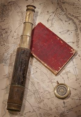
A COLLECTION OF ARTEFACTS PERTAINING TO WILLIAM COLLINGWOOD`S INDIAN SURVEYING EXPEDITION, 1846, comprising a passage journal kept aboard the Oriental from London to Bombay between 6th January and 30th May 1846, written over sixty-nine pages in a neat and clear hand with occasional coloured ink sketches, varied content including weather observations, poetry, and day-to-day commentary - March 31st 1846 Tuesday: A large shoal of porpoises playing about the bows the mate went out on the dolphin striker to harpoon one but was unsuccessful.. bound in red morocco with inscribed cover -- 7¼ x 4¾in. (18.5 x 12cm.); together with a presentation leather-cased 1½in. three-draw leather-covered surveying telescope and compass compendium signed and inscribed A. Ross, London / From Comr. Selby, Surveyor in Mesopotamia to Lieut. W. Collingwood, Asst. Surveyor, in kind remembrance of Services together in Babylonia & Irak Arabia, contained in leather carry case with lid enclosing a lacquered-brass compass, closed length -- 11½in. (29cm.); three 7 x 9in. (18 x 23cm.) watercolour and ink ship profiles by Collingwood of the Tigris; Coromandel and Georgiana each inscribed, signed and dated between 1856-8 and attached to ?album leaves; a printed service record for Collingwood (`H.M. late I.N.); and a map printed by J & C Walker, London of a Trigonmetrical Survey of a part of Mesopotamia by Selby and Collingwood , (7), Please see back cover image, Provenance: The family and thence by decent, Commander W.B. Selby, late Royal Indian Navy, began his distinguished surveying career in 1837 when, as a midshipman, he embarked on the expedition first to lay navigation buoys in the mouths of the Indus River and thence to chart some coastal areas in the `Horn of Africa`. By 1846 he was back working off the mouths of the Indus, having made his reputation in Mesopotamia (in 1840-41), and thereafter achieved considerable acclaim for his numerous other surveys, including those during the military expedition to Persia in 1856, before returning home (to England) at the end of 1862. He was succeeded as Surveyor of Mesopotamia by his protege, Lieutenant William Collingwood (a distant cousin of the Admiral), who had already done much valuable work in the region, including the large-scale, though surreptitious, mapping of Baghdad in 1855 and described by him as follows:-, "The survey of the city of Baghdad was completed entirely by myself and under very unpleasant restrictions....... The Turkish Government were not to know anything about it....... and I was left to survey the town as best I could, and under such difficulties that at times I had to note bearings and paces all over my white shirt, where best I could get the pencil at the time.....", During this same expedition, Collingwood also surveyed the Shatt-ul-Arab, the city of Bussorah (also by stealth) and much of the country between the Tigris and Euphrates Rivers, and was undoubtedly one of the most gifted and productive R.I.N. surveyors of his day.


Ulster County, NY; Hardenbergh Patent; Verplanck, Samuel (1739-1820). Map of the westerly part the Great Lot Number 6, in the Hardenbergh Patent, and southside of Papeckham River. Laid into farms at the request of Mr Samuel Verplanck AD 1771. Signed below by surveyor "Will. Cockburn". One page, 35 x 15 1/3" on vellum, in green, red and yellow natural colors. Table of the 13 smaller lots, broken down as to type of land and acreage, Explanation key and map embellishments. Born in Berwickshire, Scotland, William Cockburn settled in Kingston, NY in the 1760s and was employed as a surveyor, land agent and speculator principally in Ulster County for the Hardenbergh and Hurley patents. Small extension at right. Roll-fold, some minor soiling in bottom blank margin, overall a Fine and attractive map.

Livingston, Peter van Brugh (1710-1792). Son of Philip Livingston and Catherine van Brugh Livingston, partners with William Alexander in shipping business in New York City; became one of the original trustees of the College of New Jersey (now Princeton) in 1748; delegate to NY Provincial Congresses, and president (1775 and 1776-1777), provincial (then New York State) treasurer (1776-1778); and Alexander, William, Lord Stirling (1726-1783). Business partners with Livingston; cultivating 2,100 grapevines on his NJ estate, he helped establish viticulture and wine-making in North American colonies; a major figure in the Revolution, Williams was appointed Brig. General in the Continental Army in March 1776, praised by both Washington and the British (who took him prisoner) for his bravery in the Battle of Long island, promoted to Maj. General after his release, served with distinction up to his death months before the end of the war. Autograph Document Signed "P.V.B. Livingston" and below "Wm. Alexander". Indenture, one page, 33 1/8 x 23", on vellum, New York City, May 10, 1754. The document from Peter van Brugh Livingston and William Alexander to one Jacobus Van Dyke concerns the "Release for a House and Lot of Ground in King Street". Livingston and Alexander sign in lovely hand at the bottom right, a paper seal affixed next to each signature. At the bottom left, as witnesses to the Razure of Richard Waldron and his wife Hannah (who are part of the indenture) are the signatures of William Waddell and Gerard Bancker (the senior, his son Gerard Bancker Jr. would be a NYC surveyor, NY State Treasurer and director of the Bank of New York). In the document synopsis on verso, Jacobus van Dyke is spelled `Jacobus Van Dyck'. Light soiling generally in margins, a fine and well-preserved document.


A Fine Victorian lacquered brass box sextant Cary, London, circa 1864 The circular top plate with screw for rack and pinion index mirror adjustment against a fine inset silver vernier scale with magnification arm, the circumference with sliding pinhole shutter revealing threaded telescope mounting aperture and levers for raising/lowering the coloured glass filters, the underside with further shuttered aperture to allow filter arms to move clear when not in use, the instrument enclosed by a threaded canister-shaped cover engraved with surveyor`s table to circumference and with presentation inscription Royal Military College, Presented to Gentleman Cadet William A. Law for Attention to and Progress in Military Surveying, June 1864 to top surface, complete with single-draw telescope attachment fitted with revolving filter selection to eyepiece, in original blue velvet lined mahogany presentation box, the instrument 7.2cm (3ins) diameter, the box 12cm (4.75ins) wide. The firm of William Cary is recorded in Clifton, Gloria Directory of British Scientific Instrument Makers 1550-1851 as working from various addresses in the Strand, London 1789-1891. Gentleman Cadet William Arthur Law`s commission is recorded in The London Gazette (available online) `21st Foot, Gentleman Cadet William Arthur Law, from The Royal Military College, to be Ensign without purchase, vice Pollard, promoted, Dated 28th June 1864`, no further records of his service appear in the usual sources.


Samuel Cousins RA, British 1801-1887- Portrait of a lady, seated three-quarter length turned to the left; black chalk with touches of red chalk on buff paper, signed and dated 1842, in an octagonal mount, 27x19.5cm: British Provincial School, mid 19th century- Portrait of a man seated half-length turned to the left, traditionally held to be Thomas Skinner 1771-1854, architect and surveyor; watercolour, varnished over, bears inscription on the reverse of the frame, 24.5x19.5cm., (2) Provenance: From the collection of The Estate of the Hon Christopher Lennox-Boyd

Ray Nestor; R.F.mayer Two books on Kenya: An African Sketchbook; Kenya Camera Studies AN AFRICAN SKETCHBOOK: Ray Nestor travelled to Kenya to work as a surveyor two years before the First World War began. He returned to Kenya after enlisting and being seriously injured in the first Battle of the Somme. 111 pages detailed text and delightful book, illustrated by the author. Dustcover is not clipped, small closed tears at head of spine front and back hinge has caused a bit of curling of the top edges. KENYA CAMERA STUDIES: Mustard colour softcover wraps are rubbed and edges frittered. Map to inside of wraps. BEP heavily nibbled. Slip tipped in at fep denoting that 12 pages have been withdrawn from circulation. Stubs remain bound in where these pages have been removed, and hence pagination is not consecutive. xvi pp of preliminary text followed by 128pp of monochrome plates (less 12 as stated above). Publisher Place: England; Nairobi Publisher: Fountain Press; The east african Standard Publication Date: 1988; 1934 Condition: Very Good Size: Quarto Category: Art & Art Reference Reserve: $20 Click here to view further details and images


An Arts and Crafts late 19thC/20thC metal extending standard lamp in the Liberty / Knox Ramsden style. The lamp is raised on an open pierced and scrolling torpedo-shaped base on three heart-shaped feet. The extendable upper stem of the lamp is operated by a shaped "twist" mechanism. Provenance is by descent from a great-grandfather who was a prominent surveyor / architect in Glasgow and an avid art collector


Bradford Darby & Hulls, shelf edge hydrostatic steelyard, patent No.686 of Dec. 1753, with two sets of fulcrum pins, within a cap end pressed cardboard box, stamped with initials 'R.D', with two sliding poises, beam 17.2cm Jonathan Hulls, yeoman and inventor, and William Bradford, mathematics teacher and surveyor, of Chipping Campden took out the patent. Richard Darby was the maker (working 1753-1773).

Sauthier, Claude Joseph (1736-1802) Chorographical Map of the Province of New York in North America. London: William Faden, 1779. Extra-large map printed on multiple panels, some hand-coloring along borders, panels overlapping, some toning, fading, not excessively folded, in an older black and gilt frame, map is 56 x 73 in., frame is 61 x 78 in. overall. Sauthier, the renowned Alsatian-born mapmaker, was working as the appointed surveyor of the Province of New York as early as 1773. His detailed surveys and maps were employed to advantage by the British during the American Revolution. Richly detailed and beautifully presented, this impressive map serves as a snapshot of the complexion of New York just before the province became the state.
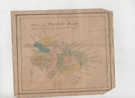
An important archive on the geology of the Lake District – Lake District – Jonathan Otley^ Clockmaker and Geologist important group of ms documents including letters^ sketch maps etc relating to Otley (1766-1856) one of the most important of the early geologists of the Lake District. The collection includes letters to Otley from correspondents discussing geological matters^ letters by Otley^ including a paper on the phenomena of floating islands^ a draft will of a local resident leaving property to Otley^ notes of a visit to Scarfell Pike ‘with Mr Dalton’ (doubtless John Dalton^ discoverer of atomic theory^ who was a friend of Otley from childhood) and approx five ms maps drawn by Otley^ one being a fine plan of Wasdale Head^ and another of ‘The Scroggs’^ Otley’s birthplace. Approx 25 separate documents in all. Otley lived his entire long life in the Lake District and was a self taught horologist^ guide^ surveyor^ map maker^ meteorologist^ natural historian and geologist.

French binoculars by LeMaire of Paris and a surveyor`s instrument (lot of 2) French binoculars by LeMaire of Paris executed in brass and leather with later gilt paint, LeMaire of Paris was one of the major suppliers of binoculars during the Civil War and was popular with officers on both sides, marked LeMaire Fabt Paris on each eyepiece with the small bee logo, 7"h x 4.5"w; together with a brass and leather surveyor`s instrument 19"l Starting Price: $75


-
1532 item(s)/page