Middlesex. Rocque (John), A Map of the County of Middlesex from an Actual Survey in four Sheets, 1757, engraved map with contemporary outline colouring, sectionalised and laid on linen, title repeated in French, mileage scale, compass rose and a decorative cartouche showing a surveyor using a waywiser, some wear and splits to the linen along old folds, edged in green silk (frayed), 520 x 685 mm, retaining the boards of a contemporary marbled card slipcase with near-contemporary ink manuscript title to the upper coverQty: (1)
We found 1532 price guide item(s) matching your search
There are 1532 lots that match your search criteria. Subscribe now to get instant access to the full price guide service.
Click here to subscribe- List
- Grid
-
1532 item(s)/page
Local Interest, Derby and Derbyshire - a collection of maps and ephemera, comprising, Derby, Board of Health Map, 120in: 1 mile, engraved and a printed in colour by Bemrose 1852, originally in four sheets each of 99 x 66cm: two copies SW section, also NW and NE sections; County Borough Council, Architects? office, C. H. Aslin, CBE, Central Improvement Plan phase 2 1944 (not built), in which it was envisaged that the centre of the town would be entirely rebuilt around a new plaza on the site of the Market Place: map of intended layout of Market Place from Albert St to the Cathedral, also map of revised traffic flow in and around the town centre, of which only Traffic Street was built 95 x 98cm each; Derby map, 1815, complied from original sources and drawn on cartridge paper by Kevin Archer of Littleover, with key to locales, armorials, MS signature of the compiler with date April 2001, 55 x 76cm; Allestree Lordship map, 1727, copy drawn from the original by Kevin Archer of Littleover, cartridge paper, Mundy armorial 36 x 45cm; Facsimile map of Derby 1791 after George Moneypenny, on cartridge paper, 33 x 30 cm; Derby OS 1:2500 map 1884 edition, copies of sheets XLIX.16 (California), L.13 (Derby E), LIV.4 (Littleover and Normanton (two), LIV.8 (Sinfin), LV.1 (Peartree & Osmaston) & LV.5 (Cottons); two reproduction prints of Bemrose lithographs showing Derby from the Meadows, and Derby from Exeter Bridge, c. 1847, both printed on cartridge paper and named, each 40 x 30cm; Conduct and Proceeding of the Rebels in Derby, reproduced in facsimile from the Derby Mercury 9/12/1745, being the paper?s account of Bonnie Prince Charlie?s stay in Derby 4-6th December 1745, with other similar extracts printed in facsimile on the reverse; Ashbourne, facsimile of the 1830 map of the town by the ?pupils of Mr. Jones?s Academy? scale 44yds: 1in., with two vignettes (church and hall) 63.5 x 43.5cm; Bolsover Civic Society poster 88 x 62cm printed on cartridge paper with descriptions, plans and elevations of buildings including the Castle 1982; Egginton, map printed on cartridge paper embellished with vignettes and descriptions, drawn 1994 in aid of St. Wilfrid?s parish church at the request of Sir Henry Every, Bt., signed by the artist, 64 x 45cm; Long Eaton Hall: three copies of Erewash Borough Council drawings made in 1922 by H. Raven, Long Eaton Urban District Council surveyor when it was proposed to purchase the property as the town hall: block site plan 46 x 77cm; plans of the hall and outbuildings by H. Raven scale 8ft:1in, 100 x 70cm & east, south and west elevations of the hall 8ft: 1in H Raven 75 x 54cm; Radbourne, three plans copied from originals in the County Record Office: plan of 1711 drawn by Thomas Hand showing the previous house and immediate surroundings 84 x 59cm; copy of a plan of part of the estate, mid-18th century 42 x 29.5cm, also copy of William Emes?s map of 1790 showing his proposed alterations to the landscape 83 x 60cm; Renishaw Hall glossy poster 42 x 59cm advertising exhibition John Piper at Renishaw September 1999 with large colour print after Piper of Montegufoni (Sir George Sitwell?s Italian house); South Wingfield, facsimile of the tithe award map 1845 (DRO 13b) 86cm x 86cm; Genealogy: two hand scrivened pedigrees relating to the Tymperley family: pedigree of George Arderne and Sibyll Arderne of Tymperley, Cheshire, showing descent from Sir John Tymperley via John Chatterton, abstracted from the Heralds? Visitation of Cheshire 1580, 48 x 60cm, also pedigree of Tymperley of Hintlesham, Suffolk, abstracted from the Heralds? Visitation of Suffolk, 1664, 31 x 45cm, the latter in clear plastic carrying tube, (qty)
EDMUND THORNTON CRAWFORD RSA RSW (SCOTTISH 1806 - 1885) - and others, an album of primarily pencil sketches, nine signed by Crawford, others unsigned, various landscape and marine subjects, together with a group of others by various hands and a number of prints, approximately 34 pictures, sizes from c. 7cm by 10cm to c. 14cm by 21cm, album lacking original boards. Album 26cm by 21cm Note: Crawford was a landscape and marine painter, born at Cowden, near Dalkeith, in 1806. He was the son of a land surveyor, and when a boy was apprenticed to a house-painter in Edinburgh. He entered the Trustees' Academy under Andrew Wilson, where he had fellow-students David Octavius Hill and Robert Scott Lauder. William Simpson, who was one of the older students, became a close friend. Crawford's early paintings were exhibited in the Royal Institution, and his first contributions to the annual exhibition of the Royal Scottish Academy appeared in 1831, two of these being taken from lowland scenery in Scotland, and the third being the portrait of a lady. Although not one of the founders of the Academy, Crawford was one of its earliest elected members. His name appears in the original list of associates, but having withdrawn from the body before its first exhibition, it was not until 1839 that he became an associate. Meanwhile he visited Holland for the first of what would be several times. He studied the Dutch masters, whose influence in forming his picturesque style was seen in nearly everything he painted. Despite acclaim and commercial success it was 1848 before he was elected a full academician. In the same year he produced his first great picture, ‘Eyemouth Harbour,’ which he rapidly followed up with other works of high quality which established his reputation as one of the greatest masters of landscape-painting in Scotland. Among these were a ‘View on the Meuse,’ ‘A Fresh Breeze,’ ‘River Scene and Shipping, Holland,’ ‘Dutch Market Boats,’ ‘French Fishing Luggers,’ ‘Whitby, Yorkshire,’ and ‘Hartlepool Harbour.’ He also painted in watercolours, usually working on light brown crayon paper, and using body-colour freely. The only picture he contributed to a London exhibition was a ‘View of the Port and Fortifications of Callao, and Capture of the Spanish Frigate Esmeralda,’ at the Royal Academy in 1836. The characteristics of his art are the old school of Scottish landscape-painting. This was not so realistic in detail as the modern school, but was perhaps wider in its grasp, and strove to give impressions of nature rather than the literal truth. In 1858 Crawford left Edinburgh and settled at Lasswade, but he continued to contribute regularly to the annual exhibitions of the Academy until 1877, maintaining to the last the high position he had gained early in life. He was at one time a keen sportsman with both rod and gun. He died at Lasswade 27 Sept. 1885, ‘Coast Scene, North Berwick,’ and ‘Close Hauled; Crossing the Bar,’ by him, are in the permanent collection of the National Gallery of Scotland and a further nineteen works are held in UK public collections.
Dean Ellis (New York, 1920 - 2009) "Thomas Jefferson" Signed lower right. Original Oil painting on Masonite. Provenance: Collection of James A. Helzer (1946-2008), Founder of Unicover Corporation. This painting is the original painting which was published on the Fleetwood First Day Cover of the U.S. 29c Thomas Jefferson Great Americans stamp issued April 13, 1993. On April 13, 1743, Thomas Jefferson was born in Albemarle County, Virginia. His father, a surveyor and cartographer, is credited with instilling in his son the importance of a sound classical education. Jefferson was only 17 years old when he entered the College of William and Mary in Williamsburg, Virginia. Despite his youth, he became friends with three of the city's leading residents -- a professor, a jurist and the lieutenant governor of the colony. Their influence led Jefferson to study law and ultimately seek a career in politics. In 1775, he was appointed to the Second Continental Congress and drafted the Declaration of Independence the following year. Although he lacked the fiery eloquence of fellow Virginian Patrick Henry, he was peerless when putting words to paper. Serving as ambassador to France after the Revolution and as George Washington's secretary of state, Jefferson ardently supported states' rights and vehemently opposed the formation of a strong central government. This put him in direct conflict with men such as Alexander Hamilton and John Adams who were Federalists. As a member of the newly formed Democratic-Republican Party, Jefferson lost to John Adams in the 1796 presidential election. However, he defeated Adams in 1800 and went on to serve two terms. During his administration he slashed the national debt and acquired the vast Louisiana Territory from France. Image Size: 18 x 21 in. Overall Size: 24 x 27 in. Unframed. (B10732)
'The Glevering Park Estate, Wickham Market, Suffolk', sale particulars/sale catalogue 1936, 43pp, large folding coloured plan as called for, 15 mounted photographic prints as called for, Glevering Hall (2876 acres), comprising Shrubbery Farm Charsfield, Brook Farm Dallinghoo, Home Farm Dallinghoo, Low Farm Wickham Market, Abbey Farm Hacheston, Glevering Watermill, former home of the Kirby family, John Kirby (1690-1753), land surveyor and topographer, author of 'The Suffolk Traveller', 1735, the first single county road-book, and father of Joshua Kirby (1716-1774), 18th-century landscape painter, engraver, writer, draughtsman and architect famed for his publications and teaching on linear perspective based on Brook Taylor's mathematics. Original printed wraps. Scarce
India, Burma & the River Irrawaddy.- Forlong-Gordon (Thomas Alexander George, Captain, surveyor in Burma, 1831-1914) Travel Journal, autograph manuscript, 310pp. excluding blanks (180pp. of diary and 130pp. of verse), a few pp. in pencil, 12 pencil sketches, some ff. loose, a few manuscript pieces loosely inserted, inner hinges broken, original half morocco, rubbed, gilt spine, some ff. edges with tears, sm. 4to, 1853-55.⁂ "... the few inhabitants are fearful of going out of their doors almost, Tigers are so numerous. A poor native has just been killed while carrying a letter across the Aracan... ." - Forlong-Gordon.Forlong-Gordon was the youngest son of William Forlong of Erines. In 1852, aged 21, he he set sail for Australia and experienced "cattle driving, horse hunting, shepherding, bullock driving... all so much in unison with my ideas of pleasure and freedom". In December 1854 he left Port Phillip on the Barque Appolline and sets sail for Calcutta. In India, he notes the high mortality rate, "Draper-dying of consumption", Bombay, "is a very dirty place... nor think it comparable to Madras. In Burma, Forlong -Gordon joins his brother in Prome as a trainee surveyor, Major General James Forlong, road engineer and later Chief Engineer to the Governor of Oudh. On the way he mentions the devastation caused by the second Burmese War and proves a perceptive observer, on tobacco production, the manner in which the natives use teak forests, the death of Captain Matagan, "killed by a band of armed Burmese... held him down while the others wounded him in 22 places", roads collapsing, difficulty of sleeping at night due to the rain and "the howling of tigers & wild elephants", visits Rangoon before leaving for India.
EDMUND THORNTON CRAWFORD RSA RSW (SCOTTISH 1806 - 1885) - and others, an album of primarily pencil sketches, nine signed by Crawford, others unsigned, various landscape and marine subjects, together with a group of others by various hands and a number of prints, approximately 34 pictures, sizes from c. 7cm by 10cm to c. 14cm by 21cm, album lacking original boards. Album 26cm by 21cm Note: Crawford was a landscape and marine painter, born at Cowden, near Dalkeith, in 1806. He was the son of a land surveyor, and when a boy was apprenticed to a house-painter in Edinburgh. He entered the Trustees' Academy under Andrew Wilson, where he had fellow-students David Octavius Hill and Robert Scott Lauder. William Simpson, who was one of the older students, became a close friend. Crawford's early paintings were exhibited in the Royal Institution, and his first contributions to the annual exhibition of the Royal Scottish Academy appeared in 1831, two of these being taken from lowland scenery in Scotland, and the third being the portrait of a lady. Although not one of the founders of the Academy, Crawford was one of its earliest elected members. His name appears in the original list of associates, but having withdrawn from the body before its first exhibition, it was not until 1839 that he became an associate. Meanwhile he visited Holland for the first of what would be several times. He studied the Dutch masters, whose influence in forming his picturesque style was seen in nearly everything he painted. Despite acclaim and commercial success it was 1848 before he was elected a full academician. In the same year he produced his first great picture, ‘Eyemouth Harbour,’ which he rapidly followed up with other works of high quality which established his reputation as one of the greatest masters of landscape-painting in Scotland. Among these were a ‘View on the Meuse,’ ‘A Fresh Breeze,’ ‘River Scene and Shipping, Holland,’ ‘Dutch Market Boats,’ ‘French Fishing Luggers,’ ‘Whitby, Yorkshire,’ and ‘Hartlepool Harbour.’ He also painted in watercolours, usually working on light brown crayon paper, and using body-colour freely. The only picture he contributed to a London exhibition was a ‘View of the Port and Fortifications of Callao, and Capture of the Spanish Frigate Esmeralda,’ at the Royal Academy in 1836. The characteristics of his art are the old school of Scottish landscape-painting. This was not so realistic in detail as the modern school, but was perhaps wider in its grasp, and strove to give impressions of nature rather than the literal truth. In 1858 Crawford left Edinburgh and settled at Lasswade, but he continued to contribute regularly to the annual exhibitions of the Academy until 1877, maintaining to the last the high position he had gained early in life. He was at one time a keen sportsman with both rod and gun. He died at Lasswade 27 Sept. 1885, ‘Coast Scene, North Berwick,’ and ‘Close Hauled; Crossing the Bar,’ by him, are in the permanent collection of the National Gallery of Scotland and a further nineteen works are held in UK public collections.
Five: Captain K. E. Baseley, Royal Engineers 1939-45 Star; France and Germany Star; Defence and War Medals 1939-45; General Service 1918-62, 1 clasp, S.E. Asia 1945-46 (Capt. K. E. Baseley. R.E.) mounted as worn, last struck on a slightly thinner flan, light contact marks, good very fine (5) £120-£160 --- Kenneth Evans Baseley was born on 7 July 1916 and enlisted in the ranks for the Royal Engineers at Southampton on 4 March 1941, an Ordnance Surveyor by trade. Commissioned Second Lieutenant on 16 July 1943, he was promoted Lieutenant on 16 January 1944, and served as acting Captain attached to 102 Indian Survey Directorate, Royal Indian Engineers, in Java from 18 April to 28 May 1946. He transferred to the Regular Army Reserve of Officers on 3 December 1951, and was granted the honorary rank of Major. Sold with the recipient’s Soldier’s Service and Pay Book; Officer’s Record of Service; and an Asian identity booklet containing a photograph of the recipient.
White Star line SS 'Titanic' - Proceedings Before The Right Hon. Lord Mersey, with Rear Admiral The Hon. S.A. Gough-Calthorpe C.V.O., R.N., et al. On a formal investigation ordered by the Board of Trade into the loss of the SS 'Titanic'. In the Wreck Commissioner's Court May/June 1912. Published by HMSO London. Unbound with hand written paper cover titled 'Evidence Given At 'Titanic' Inquiry 1st to 18th days. Incomplete - missing days 1 to 4 in list of witnesses, day 18 missing pp.503-506, appendix inserted between days 17 and 18. A rare and interesting part copy of the proceedings with unique annotations in many page margins. The first day title page is named in ink 'Mrs. Robinson', presumably Mrs. Annie Robinson First Class Stewardess and survivor, whose examination was on the eleventh day and which is partly highlighted in red pencil. The first eleven days also contain various pencil marginalia, hand unknown, together with a pencil cross-section drawing of the ship, with references to the pre-voyage fire and the engineers. The title pages of the twelfth day to the eighteenth day are all named in ink 'Mr. Boyle', referring to Alexander Boyle, with the twelfth day also bearing his professional stamp as 'Engineer Surveyor In Chief 23rd May 1912 Board of Trade'. No marginalia is found on days 12 to 18.Click here to view further images, condition reports, sale times & delivery costs for this lot.
British County Maps. Five engraved maps, 17th & 18th century, including Kitchin (Thomas). A New Improved Map of Hampshire from the best surveys & Intelligence, Divided into Hundreds..., R. Sayer. T. Bowles and John Bowles & Son, circa 1764, engraved map with contemporary outline colouring, large uncoloured allegorical cartouche, old folds, some creasing, central fold repaired on verso, right-hand margin repaired and extended, some repairs to verso, the whole backed with archival tissue, 520 x 670 mm, with another copy similar, together with Blaeu (Johannes). Bercheria vernacule Barkshire, Amsterdam, circa 1650, engraved map with contemporary hand colouring, extensive repaired closed tears to margins and extending into the printed image, some 'bleeding' of the red watercolour, old watercolour has oxidised causing splitting to the printed image, repaired on verso, slight spotting, 380 x 500 mm, French text on verso, plus Drayton (Michael). Untitled map of Middlesex and Hertfordshire, circa 1612, uncoloured engraved allegorical map, torn with loss to the printed image in the lower corners, repaired and crudely replaced in facsimile, 250 x 330 mm, and Ogilby (John). The Roads from York to Whitby and Scarborough in Yorkshire [1676 or later], engraved strip road map, sheet 100 showing a surveyor using a waywiser in the cartouche, some later crude colouring to the cartouche, toned overall, some creasing and occasional fraying and repaired tears and small holes affecting the printed image, backed with tissue 330 x 445 mmQty: (5)NOTESSold not subject to return.
LOW COUNTRIES -- KRIMPENERWAARD -- "HOOGE HEEMRAADSCHAP, Het, VANDE CRIMPENRE WAARD". (The Hague, G. v. Moelingen & J. Gijseman), 1755. Tog. 18 sheets: 6 double-p. engr. maps (the map alone: 105 x 147 cm), 4 engr. w. large coats of arms including the title banner, and 8 engr. w. large coats of arms which form - conjoined - a large wall map (tog. 155 x 195 cm). (Traces of use, some rep. to splits in places, espec. maps show some light staining/thumbing, but over all in fair condition). NOTE:Impressive polder map of the Krimpenerwaard. Donkersloot-de Vrij, 766 distinguishes 8 editions of this polder map of which this is the 6th edition, dated in the plate 1755. Each edition was printed in c. 200 copies. The surveyor was Johannes Leupenius.
AN EXCEPTIONAL 1:72 SCALE MODEL OF THE 50 GUN SALISBURY CLASS SHIP CENTURION [1774] the 24in. planked hull copper sheathed below the waterline, ebonised main and secondary wales, open gunports, guns and rings, finely carved full-length Roman Centurion figurehead, glazed stern with balcony and quarter galleries, metal anchors with bound wooden stocks, chainplates and deadeyes, planked decks with fittings including gratings, bitts, stovepipe, belfry, well deck with capstan and three fully fitted ships’ boats over, hammock nets, companionways, binnacle box with chimney, rigged double helm, deck light, shot racks, bound masts with bracing, yards with stuns’l booms and furled stitched linen sails, fighting tops, standing and running rigging with blocks and tackle and much other fine detailing. Mounted on 2 turned brass columns within wooden plexiglass case, overall measurements -- 36½ x 45½ x 16½in. (90 x 115.5 x 42cm.)Footnote: During the late 1760s, increasing colonial unrest prompted the Admiralty to expand the Royal Navy’s capabilities, most notably with the building of numerous 3rd and 4th Rate ships-of-the-line. The 4th Rate H.M.S. Centurion was one such vessel and, having been ordered on Christmas Day 1770, she was laid down in Barnard’s yard at Harwich in May 1771. Constructed to a well-tried design by Surveyor Thomas Slade, she was measured at 1,044 tons and mounted 50 guns of varying calibre, principally a volley of 24-pounders on her main gundeck. With an overall length of 146 feet and a 40½ foot beam, her dimensions were fairly standard for her tonnage and, after three years on the stocks, she was launched on 27th May, 1774. Fitted out and completed for sea just as the American War of Independence was gathering momentum, she was hastily commissioned with a crew of 350 officers and men and sent to join the fleet standing off the eastern seaboard of the United States. Joining Sir Peter Parker’s squadron of five 50-gun ships, Centurion’s first taste of action came on 8th December, 1776 when she assisted with the assault and capture of Rhode Island and Narragansett Bay, both places seen as vital to British interests. By July 1778 she was under Lord Howe’s command in the operations off the same stretch of coast and was part of the large fleet which narrowly missed clashing with a French fleet on 11th August and several succeeding days. Once France had joined the war in support of the colonists’ cause, much of the seaborne activity shifted to the immensely rich sugar islands of the West Indies, the scene of so many Anglo-French naval engagements during the second half of the 18th century. Beginning with the encounter between Rear-Admiral Barrington’s fleet and a French squadron off St. Lucia on 15th December, 1778, which resulted in the capture of that island 15 days later, Centurion thereafter played major roles in several actions and was even on hand to witness one of the last naval encounters of the war when H.M.S. Hussar engaged and captured the French frigate Sibylle off Cape Henry, Virginia, on 22nd January, 1783. Laid up for most of the following decade, Centurion was sent to the Indian Ocean early in 1794 after the outbreak of war with Revolutionary France and participated in several significant engagements across Eastern Waters during the final years of the old century, one of which brought her captain £15,000 in prize money. Her final action was undoubtedly her most spirited when, on 18th September, 1804, she was attacked by the French ‘74’ Marengo, together with two frigates mounting 76 guns between them, whilst lying in the Vizagapatam Roads [off the east coast of India] waiting to escort a merchant convoy to Madras. Despite the 3-to-1 odds stacked against her, Centurion put up a magnificent fight and, after a furious engagement lasting six hours, the French withdrew to lick their wounds leaving the convoy scattered but safe. Centurion herself was seriously damaged, however, which might explain the decision to hulk her for harbour duties in 1808, thus bringing what appeared to be a somewhat premature end to her seagoing career. Eventually finishing up at Halifax, Nova Scotia, she served as a hospital ship until she sank at her moorings on 21st February, 1824, after which she was raised and broken up.Condition report: Fine overall condition.
18th century engraving in glazed frame - map of Colchester - 'To the Society of Antiquary's in London, This Actual Survey of the Ancient Town and Borough of Colchester in the County of Essex, is most humbly dedicated by their obedient servant, Thos. Sparrow, land surveyor in Hammersmith, Middlesex, MDCCLVII' depicting a map of Colchester and vignettes of the town's ancient buildings. 52cm x 71cm.
TAYLOR, William, Land Surveyor. The Measurer's Assistant, Birmingham 1792. Owners sig. (175 x 110mm) requires rebinding, bds deficient plus Ambulator or a Pocket Companion in a Tour Round London. Jane Bew, London 1793. Library rebound in brown cloth plus an 18th century volume of Sermons. Vol 2. (of 2). only full leather (168 x 100mm) (3)
LEYBOURN, William, Philomathematicus, 'The Compleat Surveyor'. Seven books in one volume, numerous diagrams, tables etc. Sawbridge at the Signe of the Bible on Ludgate-Hill. 1679. Red and black print on title page, end papers with m/s note, owners sigs. doodles etc. Small Fo. (304 x 195mm). Full contemporary calf.
BRYANT, William Andrewes (Andrew) (1799-1878), Surveyor and Map Maker A large scale folding map in three sections of the County of Suffolk, 'from an actual survey by A Bryant in the Years 1824 and 1825, inscribed by permission to His Grace The Duke of Grafton, Lord Lieutenant and to the Nobility, Clergy and Gentry of the County, London March 1st 1826'. Hand coloured with calligraphic title, Ecclesiastical Divisions and table of Explanation, marbled backing labelled East, West and Centre with b/p for Rev. Chas. J. Steward. Somerleyton Rectory (Suffolk). Contained within a finely tooled full calf (two sectional) book box (280 x 195mm). Maps with some staining and splits on folds, box with bent corners, scuffs etc. plus Domesday Book, A facsimile of the part relating to Suffolk, Ordnance Survey, Southampton 1863, red and black print, tooled cloth boards (310 x 245mm). Bumped and worn.
WILLIAM MORRIS (1834-1896) FOR MORRIS & CO. RARE 'ST. JAMES' PATTERN WALLPAPER REPEAT, CIRCA 1881 block-printed paper, framed(118cm x 106cm)Footnote: Provenance: St. James Palace, London Literature: Clark, Fiona (editor) William Morris: Wallpapers and Chintzes, Academy Editions 1974, p. 15 and 36, no. 28 illus. Note: Morris & Co. only undertook two public commissions, and this rare repeat fragment of wallpaper comes from one of them - St James’s Palace, London. It was removed during a renovation. The other commission was for the South Kensington Museum. The two are possibly connected “through the influence of Richard Redgrave, who was both on the staff at South Kensington and, in his capacity as Surveyor of the Queen’s Pictures, was reorganising the paintings at St. James’ from 1864 onwards.”
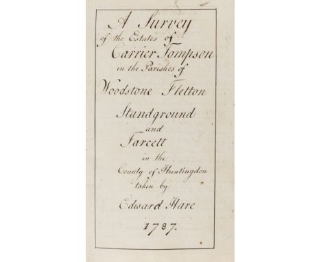
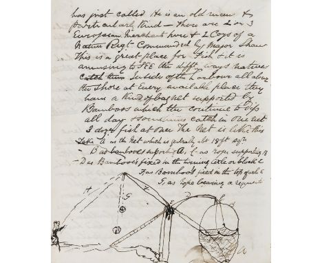
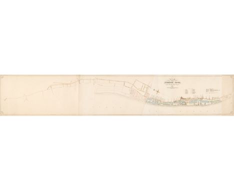
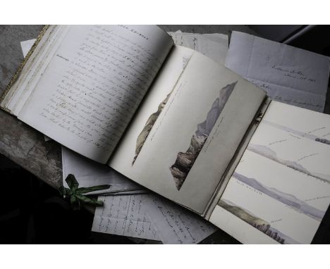
SCOTLAND - SURVEYING AND GEOLOGYIllustrated manuscript survey of the North coast of Scotland undertaken by Captain Henry Charles Otter, R.N., in 1844, describing in detail the coast from Thurso to Cape Wrath, via Sandside, the Kyle of Tongue, Loch Eriboll and the Kyle of Durness, advising on the harbours, prevailing winds, safe anchorages ('...no landing for boats except in the finest weather...') and treacherous rocks to avoid ('...give...a sufficient berth to prevent the sea... from filling the boat & at the same time to keep clear of the Black Rocks...'), geological formations ('...a conical hill 630 feet high, the upper portion of which is Gneiss intersected with veins of quartz, half way down, conglomerate, and the sea cliffs are composed of old red sandstone...'), the landscape ('...a dreary waste of hills and steep ravines covered with short heather and coarse grass...'), local flora ('...that beautiful Alga the 'Bonnemaisonia Asparagoides'...'), wildlife ('...wild fowl in great numbers... Seals also are numerous but they have been much disturbed lately...'), fishing ('...It abounds in Trout and Pike!...'), the local economy ('...vessels as large as 150 tons burden, laden with coal, tar, butter, salt etc sometimes come in here...'), ferries ('...The ferry belongs to the Duke of Sutherland, and is kept by a man who pays no rent, but is required to keep 4 men in pay & the boat in repair...'), notable coastal residences such as Bighouse ('...now in the possession of the Duke of Sutherland... no pretence to architectural beauty...'), local customs ('...the unsuspecting geese gather round... and are easily knocked down by sticks...'), history ('...It is famous for having been the place to which... the Danes... drove down the cattle... before taking them off to their ships... The above account was given to Mr Anderson of Rispond by Sir Walter Scott...'), and much else, ending with 'Sailing Directions for the Kyle of Tongue'; bound with four fine pencil and watercolour full-page illustrations on paper backed on linen, inscribed in ink and pencil, including 'Captn Slater's Monu[ment]', 'Entrance of Loch Eriboll', and 'Kyle of Durness looking up to Fionabhen and the Gualin', one pull-out depicting landscape profiles of Thurso, Entrance of Kyle of Tongue, Loch Eriboll and Entrance of the Kyle of Durness, two additional leaves with nine specimens of seaweed on cards slotted in, 67 numbered pages, plus 7 leaves of additional material, inscription on inside front board in ink 'Given by Captain Otter./ Sutherland', maroon calf gilt with blind-stamping, titled in gilt 'Description of the North Coast of Scotland. 1844' on front board and in ink on spine, marbled ends, 4to (242 x 195mm.), Thurso to Cape Wrath, 1844; with a 16 page report on the East Coast of Sutherland, signed 'Henry C. Otter/ Commander'; and four autograph letters to the Duke of Sutherland ('My dear Lord Duke') from Henry Otter advising the Duke on matters such as the local fishing industry, mentioning his disagreement with 'Mr Stevenson' over the site for a harbour at Loch Robie ('...he may find more shelter in some winds by constructing his Harbour in the Bay...'), plans for a harbour at Scullamie and his coastal surveying work for the Hydrographical Office, 22 pages, folio and 8vo, Eastlands Southsea, HMS Comet and Tobermory, 28 February 1848 to 18 August [1849] (6)Footnotes:'...THE VIEW OF BEN LOAGHAL FROM HENCE IS BEAUTIFUL, ITS POINTED PEAKS AND SALIENT SPURS CATCHING THE SETTING SUN, AND THROWING THEIR DARK SHADES INTO THE DEEP RAVINES, GIVE IT A DIFFERENT ASPECT EVERY HOUR...': A coastal survey presented to George Granville Sutherland-Leveson-Gower, 2nd Duke of Sutherland by Commander Henry Charles Otter, R.N.Henry Charles Otter (1808-1876), then commander of the cutter Sparrow, was appointed to undertake surveys of the Western coast of Scotland after the unfortunate death of Commander M.A. Slater who fell over the cliffs at Holburn Head in the course of his duties in 1842, and to whom an obelisk was erected, as described in our survey: '...near a frightful overhanging cliff 250 feet high is a small monument... from whence the late Captain Slater is supposed to have fallen... To this indefatigable officer we are indebted for the survey of the greater part of the East Coast of Scotland...'. Otter was to continue this work until 1863, and built up a reputation for taking a keen philanthropic interest in the people of the area, and for his evangelistic preaching (he and his sailors painted bible texts on the rocks at Lorn and the inscription 'God is Love' on the rocks near Tobermory Pier, which can still be seen) and, rather appropriately considering his name, for his swimming and diving abilities, having saved several of his crew from drowning over the years. In 1858, commanding the survey ship Porcupine he piloted the first transatlantic telegraphy cable in its final stages into Trinity Bay, Newfoundland, and his tidal work around the Scottish isles played a pivotal role in the later cabling of that area.As shown by the letters and report included here, the 2nd Duke of Sutherland was actively involved in the mapping and surveying of the area and sought hydrographic data to assist with his plans for developing local coastal trade and the fishing industry. This is also confirmed by correspondence held in the UK Hydrographic Office from James Loch, MP for the Wick Burghs and factor to the Duke of Sutherland (see David L. Walker, 'Admiralty Charts in the Sutherland Papers', CAIRT: the newsletter of the Scottish Maps Forum, issue 34, January 2019, pp.6-8). The fine illustrations in our manuscript attest to Otter's abilities as surveyor and mapmaker, and the Sutherland Papers in the National Library of Scotland include several manuscript charts made and amended by Commanders Slater and Otter (Dep.313/3167/58; 3624/10; 3631/1; 3631/2; 3631/3; 3631/4 and 3631/6).This lot is subject to the following lot symbols: •• Zero rated for VAT, no VAT will be added to the Hammer Price or the Buyer's Premium.For further information on this lot please visit Bonhams.com
A collection of approximately 300 Military cloth trade badges, to include: Group A Tradesmen, Anti Tank Gunners, Group B Tradesmen, Bren Gunner, Group C Tradesmen, Driver Operator, Light Machine Gunner, Light Machine Gun Marksmen, Mortarmen, Surveyor, Artificer, Driver, Course Only Trained Parachutist, Musician Bandsmen, Dog Handler, Radar Fire Control Operator, Tactics and Western Training Instructor, Rifle Marksman, Bugler, Sniper, Drummer, etc. (approximately 300)
Three: Commander W. C. Taylor, Royal Indian Marine Naval General Service 1915-62, 1 clasp, Persian Gulf 1909-1914 (Commander W. C. Taylor, R.I.M.S. Palinurus.); British War and Victory Medals (Comdr. W. C. Taylor, R.I.M.) good very fine (3) (3) £300-£400 --- Walford Charles Taylor trained in H.M.S. Conway for 2 years 1885-87, and apprenticed to Williamson Milligan & Co., Liverpool, where he served 4 years 6 months in Sailing Ships and 7 months in Steam. He obtained a 2nd mate’s Certificate of Competency in Dublin on 18 December 1890; passed for Lieutenant at Bombay on 25 January 1895; obtained the Honorary Certificate, R.N. College, Greenwich, Session 1897-98; and passed for Commander’s Certificate at Bombay on 21 September 1900. Taylor joined the Royal Indian Marine as Lieutenant and Assistant Surveyor 3rd Class on 26 October 1906. He was appointed to the Marine Survey of India and was engaged in survey work in the Indian Marine Ships Investigator from October 1907, and in Palinurus from October 1909, having been promoted to Assistant Surveyor 1st Class. He was promoted to Commander 3rd Grade on 18 July 1911 and remained in Palinurus until the outbreak of war in 1914, when he was appointed Assistant Marine Transport Officer at Karachi. He was promoted to Commander 2nd Grade in January 1915 and appointed to the command of R.I.M.S. Investigator, but actually took command of R.I.M.S. Nearchus on 18 January, which command he held until 20 March 1915, when he was appointed for General Duty and Bombay Dockyard and Assistant Port Officer, Bombay. During the war, the Royal Indian Marine was assigned tasks such as marine survey, lighthouse maintenance, troop transport and minesweeping, e.g. it kept Bombay and Aden harbours open through intensive sweeping efforts. In March 1918 he was appointed Senior Marine Transport Officer at Marmagou and, on 25 June, he took over as S.M.T.O. at Bushire where he died on 29 July 1918. He is buried in Tehran War Cemetery.
The rare M.G.S. medal for ‘Chrystler’s Farm’ awarded to Lieutenant Hector Munro, 49th Foot, who carried the colours and was slightly wounded in this action, for which only 7 officers of the regiment lived to claim the clasp; he was later a Captain in the Royal Canadian Rifles and settled in Canada Military General Service 1793-1814, 1 clasp, Chrystler’s Farm (Hector Munro, Lieut. 49th Foot) clasp face slightly bent at left side, small edge bruise, otherwise good very fine £14,000-£18,000 --- Only seven M.G.S. medals with ‘Chrystler’s Farm’ clasp issued to officers of the 49th Foot, out of a total of only 17 officers to receive this clasp from British or Canadian regiments. Hector Munro was born on 28 November 1796, and entered the army as an Ensign in the 89th Foot on 5 September 1811, aged 15 years 6 months. He served in North America from July 1812 until July 1816, initially with the 89th but was promoted to Lieutenant in the 49th Foot on 19 May 1813. He exchanged into the 103rd Foot in February 1817 and was placed on half-pay the following month. He was appointed Lieutenant in the Royal Newfoundland Veterans on 25 December 1838, transferred as Lieutenant to the Royal Canadian Rifles on 16 July 1841, and was promoted to Captain in that regiment on 14 December 1845. He exchanged to the 2nd Foot on 4 August 1848, and retired by the sale of his commission. His services are given in Hart’s Army List thus: ‘Lieut. Munro served in the American war with the 49th Regt. and was present in the actions at Prescot, Chrystler’s Farm, and Plattsburg, besides various skirmishes.’ However, as can be seen from the following biographies, Munro carried the 49th colours and was wounded at Chrystler’s Farm. The latter was almost certainly a light wound as it is not mentioned in either the casualty lists or in his record of service; not uncommon for light and in particular non-pensionable wounds. Presumably Munro carried the colours after young Ensign Richmond had been wounded. ‘Captain Hector Munro, fourth son of Captain John of Kirkton, whose descendants now represent this family in the male line, was born on the 28th of November, 1796, and entered the army in 1811, in his sixteenth year, as an Ensign in the 89th Regiment. Two years later he was promoted Lieutenant in the 49th Regiment and carried the colours at Chrystler's Farm for which he received a medal and was wounded. He was also present at Plattsburg and Lundy's Lane. He was placed on half-pay on the 25th of March, 1817, from the 103rd Regiment, but on the 25th of December, 1838, was again placed on full pay as Lieutenant in the Royal Newfoundland Veterans, and when the Royal Canadian Rifles were formed he obtained a company in 1846. He soon after exchanged into the 2nd Regiment of Foot, or Queen's, and retired by sale of his commission in 1848. In 1859 he was appointed Surveyor of Customs at Galt, Ontario, an office which he held for the remainder of his life. He was for several years President of the Galt and Hamilton Highland Societies, and it was largely owing to his patriotic exertions that the fine and striking monument, on which his name appears as hon. secretary, was erected at Queenston to the memory of Sir Isaac Brock.’ (History of the Munros refers). ‘HECTOR MUNRO, deceased, father of L. H. R. Munro, was born at Dornoch, Scotland, in 1796. He came to Canada in 1812 with the 49th Regiment, being a brother officer of Sir Allan McNab. He participated in the battles of Chrystler’s Farm, Queenston Heights, and Lundy’s Lane, and carried the colours at Chrystler’s Farm. After the war he retired on half-pay; and, when again placed on full pay, was stationed at St. John’s, Newfoundland, from which he removed to Toronto, having been transferred to the Royal Canadian Rifles. He subsequently filled the position of Collector of Customs at Galt, until 1854, when he died, leaving eight children. His son, George T. Munro, who had been retired as a captain on half pay on the disbanding of the Royal Canadian Rifle Regiment with his wife and child and youngest sister were lost at sea on one of the Allan vessels the Hazeldean, in 1870.’ (History of Toronto and County of York, Ontario, Volume 2, refers) Hector Munro died at Galt, Ontario, on 12 February 1868. Sold with comprehensive research on CD.
Leybourn (William). Cursus Mathematicus. Mathematical Sciences, in Nine Books. Comprehending Arithmetics... Geometry... Cosmography... Astronomy... Navigation... Trigonometry... With the Description, Construction, and use of Geometrical and Nautical Instruments: And the Doctrine of Triangles applied to Practice in Mensurations of all kinds..., 1st edition, London: Printed for Thomas Basset, Benjamin Tooke, Thomas Sawbridge, Awnsham and John Churchill, 1690, engraved portrait frontispiece by R. White (detached with frayed margins), title printed in red and black, 44 engraved plates (35 folding), illustrations, title and dedication detached, leaf 2E2 (i.e. Book II sectional title bound after 2E3), engraved plate of the moon (between pp. 446-447) bound upside down, occasional early annotations, a few closed tears some browning and damp stains, early ownership signature of R. Grove?, contemporary calf, covers detached, some wear, folioQty: (1)NOTESESTC R2239; Wing L1911. Provenance: Christopher Hussey (1899-1970), British architecture authority, presentation inscription to George Barnes, 1959, and small label 'Scotney Castle, Lamberhurst' (Hussey's family home) to front pastedown. William Leybourn (1626-c.1700) was a mathematician and land surveyor, published this encyclopaedic work in 1690, 'This is a folio volume of over nine hundred pages and includes the substance of his former publications.' (DNB).
British Isles. Blaeu (Johannes), Anglia Regnum, Amsterdam, circa 1662, engraved map with contemporary outline colouring, slight spotting and dust soiling, upper margin strengthened on recto, 385 x 500 mm, Spanish text on verso, together with Blome (Richard). A Mapp of Staffordshire with its Hundreds, circa 1673, engraved map, hand-coloured in outline, 330 x 245 mm, with Morden (Robert). Cheshire, circa 1705, uncoloured engraved map, 165 x 200 mm, plus Williams (G. Commander, surveyor). Isle of Man, Admiralty chart, 1846, last update 1977, colour photolithographic map, inset maps of Port Erin, Peel, Calf Sound, Castletown Bay, Ramsey Bay & Port St. Mary, the title of each inset map scored through in biro, old folds, slight browning, 1020 x 665 mm and Mount (William & Page Thomas). A New and Correct Draught of the Channell between England & France, shewing ye Sands, Shoales, depth of Water & Anchorage on ye said Coasts with the Setting of the Tydes and the time of High water as observed by Capt. Edm. Halley, circa 1748, an uncoloured engraved chart on two conjoined sheets, inset map of the Scilly Isles, horizon profiles to upper margin, compass rose and numerous rhumb lines, old folds, heavily dust-soiled, some spotting and staining, near-contemporary manuscript annotations to verso, 450 x 815 mm, together with Faden (William). A Map of the Mediterranean Sea with the Adjacent Regions and Seas in Europe, Asia and Africa, 1785, engraved map with bright contemporary hand colouring, large uncoloured allegorical cartouche, 605 x 850 mmQty: (6)NOTESThe Mount and Page chart of the English Channel was an immediate reaction to Edmond Halley's 'Fundamental Thematic Map of the English Channel'. The importance of understanding longitude was well known, but the tidal flow of the seas and their unpredictability was a major navigational hazard resulting in heavy losses of vessels, especially on the approach to harbours and ports. Halley's voyage aboard the "Paramore" in 1701, enabled him to produce a map of the English Channel which for the first time, enabled a prediction of the tides. Its genius was that it made something that was extremely complicated, understandable by 18th-century mariners. Mount & Page published a derivative map in 1702 and this example was published in the 'English Pilot' of 1749.
Manchester. Laurent (C.). A Topographical Plan of Manchester and Salford with the adjacent parts; shewing also the different allotments of land proposed to be built on as communicated to the Surveyor by the respective Proprietors..., Dec. 9th 1793, large uncoloured folding map, inset strip road map of the route from Manchester to London, inset plan of Manchester and Salford and an inset map of the Country around Manchester, old folds with occasional short splits along the fold, slight spotting and toning, 990 x 920 mmQty: (1)NOTESThe map was used to illustrate Aikin's 'Description of the Country from Thirty to Forty Miles Round Manchester'.
Ogilby (John). The Road from London to Holy-head co. Anglesey North Wales, The Continuation of the Road from London to Holy head, The Continuation of the Road from London to Holy head [and] The Continuation of the Road from London to Holy head, [1675 or later], together 4 consecutive uncoloured engraved strip road maps, the first commencing at London with a cartouche showing a surveyor using a waywiser, very slight staining, each approximately 350 x 455 mmQty: (4)NOTESThe four sheets showing the complete route from London to Holyhead. Sheet numbers 21, 22, 23 & 24.
* Poland. Blauvitz (Christoph), N - Ro I. Diese Carte zeiget uns dass Hoch Freiherrl. Fidei Comiss guth Praub mit dem herschafftlichen Schlob und forweds gebäuden auch Kirch und Pfarr haub sambt allen ... Und zu gehörigen Feldern..., A Manuscript plan of Prusy (Prauss) in Strzelin (Strehlen) County near Breslau, circa 1740, a pen and watercolour plan of the village of Prauss, a large decorative cartouche, compass rose and mileage scale showing a surveyor using a pair of dividers, old folds, some creasing, occasional repaired closed tears, 425 x 860 mm, mounted, framed and glazedQty: (1)NOTESPrauss (now Prusy) is a village in South-west Poland. This plan was made during the First Silesian War (1740 - 42) between Prussia and Austria and the Prussian victory and the subsequent 'Peace of Breslau and the Treaty of Berlin resulted in the bulk of Silesia and the Bohemian County of Kladsko being ceded to the Prussians. This area was later consolidated as the Province of Silesia.
Africa.- Smith (William) A new voyage to Guinea: describing the customs, manners, soil, Climate, Habits, Buildings, Education, Manual Arts, Agriculture, Trade, Employments, Languages, Ranks of Distinction..., first edition, 5 engraved plates, some spotting and staining, 19th century speckled calf, gilt, covers detached, 2 pieces from backstrip loosely inserted, rubbed, [Sabin 84559], 8vo, Printed for John Nourse at the Lamb without Temple Bar, 1744.⁂ William Smith was surveyor to the Royal African Company. He undertook his voyage in 1726 with the aim of making surveys and drawings of all English settlements in Guinea. Includes material on the slave trade. Provenance: Charles George Milnes Gaskell (oval bookplate).
HMS Victory & Royal Navy ships.- British Navy M.S.S. Extracts from Navy Office, manuscript, 37pp., ruled in red, slightly browned, ff. loose, bookplate of Henry B.H. Beaufoy on front pastedown, original half calf, gilt morocco label on upper cover, covers loose, corners and edges worn, lacks spine, folio, date from upper cover 1805.⁂ An extract of naval ships, listing their specifications, from the 18th century and up to the year of Trafalgar. "[HMS] Victory... S[i]r T[homas] Slade Surveyor [shipbuilder]... Number of Men 850... Number of Guns 100... ." Pencil inscription on front pastedown by ?Henry Beaufoy, "Confidential and Official from the records of the Office by... Captain James Scott for Colonel Mark Beaufoy... HB." Notes at end comprise, "Dimensions of Masts and Yards" and "Charges for taking the following Ships to Pieces."(1). Sir Thomas Slade (1703/4-71), shipbuilder (2). Mark Beaufoy (1764-1827), astronomer and physicist; the first Englishman to climb Mont Blanc; experimented on solids moving through water (3). Henry Benjamin Hanbury Beaufoy (1786-1851), businessman and politician.
Middle East.- War Office (Geographical Section) Sketch Map of Arabia, map of the peninsula, with inset map of 'Koweit', several black ink inscriptions and annotations, lithograph printed in blue and black, sheet 490 x 475 mm (19 1/4 x 18 3/4 in), nicks and tears to extremities, some handling creases and minor surface dirt, unframed, 1835 with corrections July, 1905, Railways revised Sept. 1906; together with an Indian map of Baluchistan, heliozincographed at the Survey of India Office, Calcutta, 580 x 455 mm (22 3/4 x 17 7/8 in), folding into brown paper ends with title printed on upper cover, published under the direction of Col. F. B. Longe, R.E., Surveyor General of India, 1910 (2)
Five images of the Moon taken from orbit, comprising: 1) Crater Schmidt (RED NUMBERED NASA AS10-34-5161)2) Oblique view across the northern edge of Keeler (RED NUMBERED NASA AS10-34-5171)3) Sinus Medii; prominent craters are Blagg (foreground) and Bruce (BLACK NUMBERED NASA AS10-27-3905)4) Landing site 2 (BLACK NUMBERED NASA AS10-34-5158)5) Sinus Medii including Surveyor 4 and 6 landing sites. Crater Bruce in foreground. (RED NUMBERED NASA AS10-27-3908)Five vintage chromogenic prints on fibre-based paper, 25.5 x 20.5 cm (10 x 8 in), on A KODAK PAPER watermarked stockCondition Report: Overall condition on each photograph is very good. Each photograph has a number inscribed in pencil on the verso; photo 5 has an 'Apollo X' annotated in biro on the verso. Fronts are not affected.Condition Report Disclaimer
Peter ConradTwo lunar views at the Ocean of Storms, including a portrait of the photographer's shadow with the US flag; Surveyor Crater is illuminated by the rising sun19 November 1969Two vintage gelatin silver prints on fibre-based paper, each 20.3 x 25.4cm (8 x 10in), the first numbered in margin NASA number AS12-46-6752 (NASA/USGS), the second BLACK NUMBERED NASA AS12-46-6763 in top margin, with NASA MSC caption on the verso (NASA Manned Spacecraft Center)Footnotes:Two very rare frames from Conrad's 4 o'clock 360° panoramic sequence of the Ocean of Storms landing site.'Here, on the sunny Sea of Storms, the crew of Intrepid had cause for their ebullience. They had eight hours, twice as much as their predecessors, Armstrong and Aldrin, to explore, set up experiments and collect more and bigger rocks.' Life Magazine, 12 December 1969
Alan BeanFour images of Surveyor 3 taken by the Apollo 12 astronauts (all photographs taken with black and white magazine 48 during second EVA), comprising: 1) Charles Conrad inspects the Surveyor 3's TV camera prior to detaching it (BLACK NUMBERED AS12-48-7134)2) Unusual view showing two NASA spacecraft on the lunar surface. In the foreground is Surveyor III which landed on the 19 April 1967, in the background is the Apollo 12 Lunar Module (BLACK NUMBERED AS12-48-7099)3) View of Surveyor III in its crater, with Lunar Module to far left (BLACK NUMBERED AS12-48-7090)4) A close-up view of a footpad of the unmanned Surveyor 3 spacecraft (BLACK NUMBERED AS12-48- 7110)20 November 1969Four vintage gelatin silver prints on fibre-based paper, 25.3 x 20.5 cm (10 x 8 in), all BLACK NUMBERED and with NASA MSC captions on the versoFootnotes:[NASA caption] The Apollo 12 Lunar Module landed about 600 feet from Surveyor III in the Ocean of Storms. The television camera and several other pieces were taken from Surveyor III and brought back to Earth for scientific examination.
Alan BeanPeter Conrad at the Surveyor III robotic probe20 November 1969 Vintage gelatin silver print on heavy stock fiber-based paper, 25.4 x 20.3 x 25.4 cm (10 x 8 in), BLACK NUMBERED NASA AS12-48-7134 Footnotes:'This image is symbolic of our mission. Our objective was to perform a pinpoint landing at the Surveyor 3 target site at the rim of the Surveyor Crater. This precision landing was of great significance to the future exploration program because landing points in rough terrain of great scientific interest could then be targeted.' Richard Gordon
Camera onboard the Surveyor I robotic spacecraft1) Boulder-strewn surface of the Moon's Ocean of Storms shows the outside of a crater rim along right centre of the horizon. (NASA photo no 66-H-776)Image transmitted to Earth on the morning of June 5 1966 as Surveyor I began its fourth day of operation on the lunar surface.2) Horizon of the Moon. Horizon is tilted because the camera is tilted. Camera is pointed almost directly at the sun, which is out of view. Bright circles in sky are reflections of the sun caused by the camera mirror. (NASA photo no 66-H-591)June 2, 1966Two vintage gelatin silver prints on fibre-based paper, 20.6 x 25.4cm (8 x 10 in), both with NASA HQ captions mimeographed on the verso Condition Report: 1) A couple of minor handling cracks, otherwise good2) Very goodCondition Report Disclaimer
Cameras onboard Lunar Orbiter 3's robotic spacecraftA mosaic of three photographs showing three views of the area on the Moon where Surveyor I landed on 2 June 1966; the landing area is circled or squared in each photograph22 February 1967Vintage gelatin silver print on fibre-based, 25.5 x 10.5 cm (10 x 8 in), with NASA Headquarters caption on the verso Condition Report: Very goodCondition Report Disclaimer
A group of three photographs, depicting Surveyor 3 working through the trenches, scooping up lunar soil samples by the use of the scoop.April/May 1967Three gelatin silver prints on fibre-based paper, 25.5 x 20.5 cm (10 x 8 in), NASA photo nos. 67-H-842, 67-H-844, 6-H-468, with NASA HQ captions on the versosFootnotes:Surveyor 3 was the first robotic probe from the Surveyor programme to be equipped with a soil scooper. The mechanical scoop extended out on an arm of approx. 120 cm. It dug, scraped, scooped and lifted up the soil samples that were then photographed by the television camera installed onboard and transmitted back to earth for analysis. The television camera and the scoop were later collected by the Apollo 12 crew and returned to earth.
A plan of the estate belonging to the trustees of The Late Miss Mary Heald, Brant Broughton and Beckingham, for sale by auction 1873, produced by R J Booth surveyor and Co Wainfleet Lincolnshire, and an estate sale comprising a messuage or dwelling house, Brant Broughton and Beckingham, conducted by Messrs Elston Law and Sons at The Clinton Arms Hotel, Newark on Trent, 1873. (2)
Estate plan. Singer (Joseph, Land Surveyor), A Plan of an Estate lying in the Parish of Frome Selwood and County of Somerset belonging to Mrs S. Haynes, 1779, large pen and watercolour estate plan laid on near-contemporary textured cotton, strapwork cartouche with a pen and ink vignette of a watermill, compass rose, table of explanation and a scale of chains and furlongs, the map is reticulated with an alphabetised key in the margins, some later pencil annotations, old folds, some creasing, slight surface abrasion but largely confined to margins, 875 x 970 mmQty: (1)NOTESAn unusually large estate plan centred on Keyford and Frome.
Duval (Pierre). La Connoissance et l'usage des globes et des cartes de ge?ographie, Paris: L'autheur, 1654, 91,[1]pp., worming to fore-edge margins throughout volume (occasionally affecting text), contemporary limp vellum, near detached, marked and soiled, slim 12mo, together with: Burnet (Thomas), Thesaurus Medicinae Practicae..., 2 volumes in one, Geneva: Joh. Herm. Widerhold, 1678, engraved title, occasional light damp staining, contemporary vellum, thick 12mo, Wyld (Samuel), The Practical Surveyor, or the Art of Land-Measuring made easy..., to which is added, an Appendix, 5th edition, London: W. Johnston, 1764, folding engraved frontispiece and six folding plates, contemporary calf, rebacked, morocco title label, boards rubbed, slim 8vo, and an incomplete copy of A Description of the Air-Pump, made in Form of a Table; with the manner of making the most curious experiments thereon, by Thomas Ribright, London: Sold by the Maker, Thomas Ribright, Optician to His Royal Highness George Prince of Wales, in the Poultry, 1759, folding engraved frontispiece (pencil drawing to verso), lacking final four leaves (pages 17 - 24), original wrappers, side stitched as issued, slim 8voQty: (4)
A Topographical Plan of Manchester and Salford, with the adjacent parts, shewing also the Different Allotments of Land proposed to be built on, As communicated to the Surveyor by the respective Proprietors (...), published December 9th 1793, by C. Laurent, the map lined on fabric, 108 cm x 95.5 cm
Manuscript Estate MapsNorthern Ireland: Fraser (John) Surveyor, A Collection of 5 large Mansucript Estate Maps, of Mullinlauphy, (c. 180 1/2 acres); Tinnacaghill (c. 113 acres); Drimmeenen, (c. 305 acres); Corveen & Birchill, (c. 206 acres). Surveyed in 1833, each approx. 21 1/2" x 30" (55cms x 76cms), and each field with tenant's name, area of ground, and rent payment. All in good condition, signed by surveyor and dated. As maps, w.a.f. (5)
Thomas William Whipp ARIBA (1880-1950) (Chartered Architect and Surveyor): Quantity of architectural drawings and plans relating to Scarborough including: Manor Road Boarding House 1932, Temperance Hall Falsgrave Road 1935, Londesborough Theatre and Picture House 1930 Cooperative Bakery Victoria Road 1938, 4 Valley Bridge Parade 1927, Cooperative Society 181-183 Dean Road 1931, Mill Lane Bakery 1938, housed in a canvas steamer style trunk, wood and metal bound, L91cm - Condition Report
Manchester. Laurent (C.). A Topographical Plan of Manchester and Salford with the adjacent parts; shewing also the different allotments of land proposed to be built on as communicated to the Surveyor by the respective Proprietors..., Dec. 9th 1793, large uncoloured folding map, inset strip road map of the route from Manchester to London, inset plan of Manchester and Salford and an inset map of the Country around Manchester, old folds, very slight staining, 990 x 920 mmQty: (1)NOTESThe map was used to illustrate Aikin's 'Description of the Country from Thirty to Forty Miles Round Manchester'.
Electrical and Other Measurement Equipment, including an Evershed & Vignoles direct reading resistance box for use with a "Megger" instrument, a Muirhead decade resistance box, a military surveyor/mapping rule in wooden case, a Rabone wooden spirit level, several hinged measuring rules, a Fowler circular long scale calculator in a leather case
Epping Forest. Plan of Waste Lands in the Northern Portion of Epping Forest in the County of Essex [and] Plan of Waste Lands in the Southern Portion of Epping Forest in the County of Essex..., within the meaning of the Epping Forest Act 1871, as ascertained by the Epping Forest Commissioners and referred to in their Scheme dated 23rd day of February 1877, two colour lithographic maps, the Southern Portion on three sheets, the Northern portion on four sheets, facsimile signatures of the commissioners and surveyor, old folds, some dust soiling and slight spotting, one marginal stain, all laid on contemporary stiff paper with manuscript labels to verso, the overall size (if conjoined) of the Southern Portion, 935 x 845 mm, the overall size (if conjoined ) of the Northern Portion 1840 x 655 mm, contained in a later card folder, frayed and wornQty: (2)NOTESScarce. We can find no auction records for this map, but there appears to be a copy held in the National Archives at Kew and another in The British Library.
Forest of Dean. Atkinson (John), Plan of Her Majesty's Forest of Dean, in the County of Gloucestershire, with High Meadow and Great Doward Woods by John Atkinson, Mineral Surveyor, one of the Deputy Gavellers of Her Majesty's Forest of Dean,1842, large map, engraved by J & C Walker, with contemporary outline colouring, sectionalised and laid on linen, calligraphic cartouche, compass rose and table of explanation, heavily spotted, 1350 x 1060 mm, contained in a contemporary morocco gilt slipcase, worn and frayedQty: (1)NOTESScarce.
Campbell (Colen). Vitruvius Britannicus, or the British Architect, Containing the Plans, Elevations, and Sections of the Regular Buildings, both Publick and Private, in Great Britain, with Variety of New Designs ... either from the Buildings themselves, or the Original Designs of the Architects, 3 volumes, 1st edition, London: 1715, 1717, 1725, engraved title to volumes 1 & 2, engraved dedication leaf to volume 1, letterpress title to volume 3 in red & black, 211 engraved plans & elevations only (includes 44 double-page & folding, comprising individual plate numbers to each leaf), subscribers lists present, volume 1 double-page plate of Wansted House West Front with closed tear to central fold and double-page plate Elevation of one wing of Great Court of Greenwich Hospital creased, volume 2 plates 46 & 59 with ink splashes & specks, double-page plate of Longleat with vertical closed tears and double-page plate 99/100 marked & dust-soiled, volume 3 plates 89 & 90 misbound, occasional toning, dust-soiling and few marks, armorial bookplate of Lord Napier to upper pastedowns, front free endpapers with later ownership inscription 'Thomas Balbirnie, Architect & surveyor, Glasgow, 1846', contemporary half calf with vellum corners (volume 3 lacking corners), marbled sides, spines and some marbled sides torn with loss, worn, folioQty: (3)NOTESHarris 97 & 99; Archer 32.1 & 33.1; Fowler 76. Volume 1 lacking double-page plate numbered 86/87 - Greenwich Hospital Double Pavilion to the river. Volume 3 lacking double-page plate numbered 3/4 - Greenwich Hospital in Perspective, and double-page plate numbered 5/6 - Castle Howard in Perspective. Thomas Balbirnie (1816-1867) was an architect and surveyor. In 1847 he married Ann, youngest daughter of Captain Robert Alward, of Brixham, Devon. Thomas travelled to the United States in 1850 and was the architect for some several structures in the city of Baltimore, including the Madison Avenue Methodist Episcopal Church.
Photography - The British Empire, Colonial Africa - three photograph albums containing b/w photographs taken by William Willows Baxter Kitching (1887-1958), during his time as a surveyor for the British Colonial Service from 1914-1933, volume I illustrating Kenya and its capital Nairobi's imperial architecture, the people of the Kikuyu tribe and their dance (the Ingoma), court of justice and warriors armed with spears and shields, further shots of Kitching on leave at Llansteffan Castle, Wales; volume II showing occupied German East Africa in 1916, including scenes of World War One - a Mbgathi horse camp, a mud-stranded armoured car, a train that had detonated a German mine, Red Cross transport and a hospital train, other more leisurely images: big game hunting, other African views of Mobasa, Zanzibar, Beira, Laurenco Marques, Durban, Port Elizabeth and Cape Town, and a large picture of a young lion taken by Cherry Kearton (1871-1940); volume III with further views of Nairobi, the 1919 Mombasa Peace Celebrations, more big game shoots and hunting, 1919 leave home via Naples, Marseille and Norway!, the return in 1921 via Madeira, 1924 leave then via Genoa, Port Said, Aden, Lugano and Venice, Crossing the Line in 1927 with his new bride Ethel (née Radford Cooper of Derby), their marital home Mwanza and a safari in a Chevrolet lorry, 1930 leave: Pisa, Florene, Lugano and Venice, its art and architecture, then back to Africa in 1932, oblong albums, mixed bindings and sizes, [3]
Epping Forest.- Driver (Robert, surveyor) Plan in Four Parts of Waste Lands in the Northern Portion of Epping Forest, within the Meaning of the Epping Forest Act, 1871, partially coloured map divided into four sections, mounted on linen and folding, each section 640 x 440 mm. (25 x 17.5 inches), overall 50 x 35 inches, on a scale of 6.4 inches to 1 mile, plans 3 and 4 water-stained, affecting colour of linen more than map surface, which is lightly stained; Plan in Three Parts of Waste Lands in the Southern Portion of Epping Forest, three sections mounted on linen and folding, each 820 x 320 mm. (33 x 12.5 inches), overall 33 x 37.5 inches, the seven parts each folding into cloth covers and together in one cloth slip-case, 8vo, [c.1880].⁂ Very scarce. The maps were produced as part of the negotiations in which the City of London took over the forest to protect it from development and to open it to the public. They provide a very detailed survey of the whole of the forest, not just the nominal waste land. Although the maps are not dated, surrounding developments suggest a date of around 1880, and this is consistent with a related manuscript map in the Public Record Office signed by Driver and dated 1882. Driver was a founder member and one-time President of the RICS, greatly concerned with the interests of the poorer members of society.
Huntingdonshire.- Hare (Edward, surveyor, of Castor, near Peterborough, 1741-1816) A Survey of the Estates of Carrier Tompson in the Parishes of Woodstone Fletton Standground and Farcett in the County of Huntingdon..., manuscript, title and 49pp., original roan, worn, wormtracks with loss, remains of brass clasps, 8vo, 1787; and c. 30 others, including a printed Enclosure Act of Fletton, indentures etc., v.s., v.d. (c. 30).⁂ Fletton and Stanground are now southern suburbs of Peterborough.
Aberdeen.- Fordyce (Capt. Alexander Dingwall of Culsh and Brucklay, R.N., M.P., naval officer and whig politician, 1800-1864) List of Household Furniture in Captain Fordyce's House in 6 Albyn Place, 20+3pp manuscript inventory, each page initialed by the surveyor J.H. Hill, contemporary marbled wrappers, 4to, Aberdeen, June 1st 1856.
* Attributed to Charles Leander Weed (1824-1903). Yangtsekiang from I Chang (Hoopeh) to Kwei Fu (Szechuen)… by Francis Ingram Palmer, 1869, c. 1870, mammoth albumen print of Palmer’s hand-drawn map showing the route of Robert Swinhoe’s expedition up the Yangtze River in June 1869, with 19 vignette views and cartouche below, 38.2 x 50.4 cm (15 x 19.9 ins), folded vertically and split at head of ‘centrefold’ with minor loss and continuing diagonal closed tear repair descending diagonally left, small splits to lower margin without loss, some browning to centrefold and margins, lower left corner tipped onto a contemporary album leaf, 27.5 x 38.5 cm, together with Illustrations of China. Scenery of Formosa [Taiwan]. Chinese Architecture, Manners & Customs, c. 1870, calligraphic title-page in brown ink on an album leaf, minor marginal fraying, 27.5 x 38.7 cmQty: (2)NOTESFourth photograph: Terry Bennett, History of Photography in China: Western Photographers 1861–1879, (2010), p. 157, fig. 127; Clark Worswick, Imperial China: Photographs 1850-1912, (1979), p. 41. This mammoth-plate photograph, the only one in the collection, may well be unique and may provide a clue as to the original ownership of this collection. The artist-surveyor of the map and drawings in the photograph was Navigating Sub-Lieutenant Francis Ingram Palmer. Palmer was a skilled artist and was employed by the Admiralty in surveying the coasts of Japan and China on HMS Sylvia in 1869. On this trip up the Yantztze River in 1869 the senior surveyor was L.S. Dawson. The expedition itself was led by Robert Swinhoe, HM Consul in Treaty Port China from 1854 to 1873. Swinhoe's account of the expedition was given in an account read before the Royal Geographical Society on 9 May 1870. It would seem most likely that either Palmer, Dawson or Swinhoe would have arranged for this expensive photograph of the map and drawings to be made. The uniform calligraphy on the album leaves suggests that these captions could not have been written before 1871 when Thomson photographed in Formosa and by which time Palmer was back in England and Weed back in America. This photograph has no caption on the mount and one can speculate that perhaps Weed or Thomson wanted this photograph of the map and vignette drawings for their personal use.
Lunar 1. A set of four large format vintage NASA gelatin silver high resolution prints of the moon's far side: numbered for the location IS-9, exposure I-136 H1/H2 & H3 and I-136M, also marked 'NASA -LRC' lower right margin.*Notes- Taken by the 1966 Lunar 1 Orbiter Space programme which was the first American spacecraft to orbit the moon surveying and recording the surface for possible landing sites of the Surveyor and Apollo missions.
Raspe,R.E.Raspe,R.E. Specimen historiae naturalis globi terraquei, praecipue de novis e Raspe,R.E. Raspe,R.E. Specimen historiae naturalis globi terraquei, praecipue de novis e mari natis insulis,... Hookiana telluris hypothesi,... Amsterdam u. Lpz., Schreuder & Mortier 1763. Mit 3 (davon 2 gefalt.) Kupfertaf. XXII, 191 S. Einf. Pbd. d. Zt. (Fleckig u. berieb.). Roller-G. II, 342. Hoover 160. Honeyman 2578. Erste Ausgabe. - Zur Abfassung seines Werkes wurde Raspe durch das große Erdbeben von 1755 in Lissabon angeregt. - 'Cleverly interwove his own ideas with those of Robert Hooke on the origin of new islands and mountains from subterranean forces... he worked as a translator, industrial spy, and mine surveyor, finding time even for the authorship of the famous Baron Münchausen stories' (Hoover). - Wasserrandig, S. 39/40 mit ob. Randabriß. - Exlibris.

-
1532 item(s)/page