We found 1532 price guide item(s) matching your search
There are 1532 lots that match your search criteria. Subscribe now to get instant access to the full price guide service.
Click here to subscribe- List
- Grid
-
1532 item(s)/page
![[Plan of New York City], "Plan of the City of New York, Drawn from the Actual Survey by Casimir Goerck and Joseph Mangin, Cit](https://cdn.globalauctionplatform.com/3554f1f8-89cc-4c26-84e2-a90d012e2a82/3216adf4-9c5b-43b6-f1d5-8d42dacd462a/468x382.jpg)

Lot 672
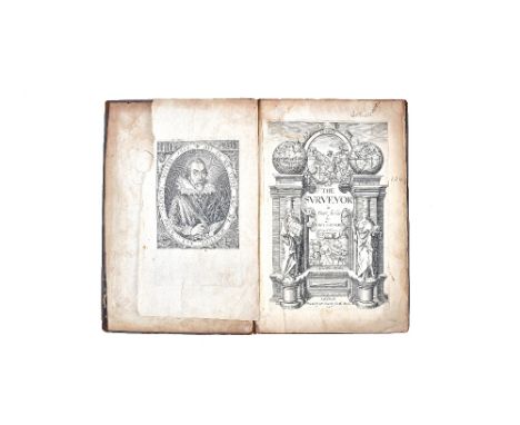
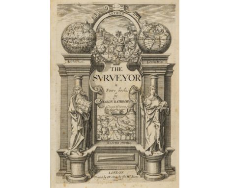
RATHBONE (Aaron) - The Surveyor in Foure bookes. First Edition. engraved pictorial title (by Wm. Hole), portrait of the author & portrait of Charles, Prince of Wales (the dedicatee), num. text diagrams, headpiece decorations, contemp. gilt & blind-ruled decorated calf, panelled spine & gilt emblematic device on covers, 4to. printed by W. Stansby for, W: Burre, 1616. * i.e. Bookes 1 - 3 only, the fourth being concerned with legal & manorial issues; an important & influential text; one apparently being taken on the 'Mayflower' to the New World. Illustrated
Lot 60
Virginia map.- Dedman (Samuel, surveyor) 906 acres... Mecklinbugg County... Survey'd for Roger Atkinson..., D.s. "Saml Dedman", small manuscript map at head and description of the estate, 1p., docket on verso, 4 folds (first fold detached), browned, watermark Arms of Amsterdam, folio, 22nd September 1783.⁂ Survey'd for Roger Atkinson, 906 Acres of Land Lying on the South branch of Mehirrin [Meherrin River], in the County aforesaid... ."
Lot 339
Surveying.- Leybourn (William) The Compleat Surveyor, third edition, engraved portrait frontispiece, title in red and black, 5 folding engraved plates, engraved and woodcut diagrams, slight worming to upper inner corner throughout, mostly marginal but occasionally touching headline, contemporary calf, gilt arms of William Tighe to covers, rubbed, [Wing L1909], Printed by E. Flesher for George Sawbridge, 1674; and 14 others including a fourth edition of the same work, 1679, v.s. (15)
Lot 450
Surveying.- Wyld (Samuel) The Practical Surveyor, or, the Art of Land-Measuring, Made Easy, first edition, engraved folding frontispiece and 5 plates, occasional browning, contemporary calf, sympathetically rebacked, J. Hooke & J. Sisson, 1725 § Davis (William) A Complete Treatise on Land Surveying, third edition, 7 engraved folding plates, contemporary tree calf, by H.D. Symonds, 1804; and 3 others, surveying, 8vo (5)
Lot 461
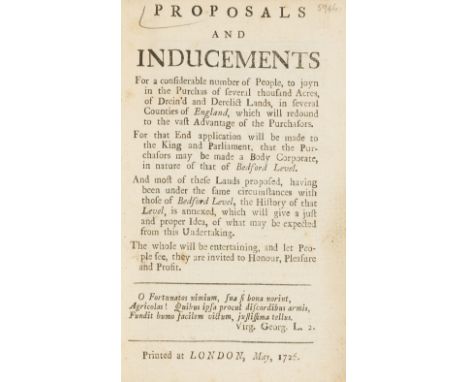
Fens Drainage.- S. (R.) Proposals and Inducements for a considerable number of People, to joyn in the Purchas of several thousand Acres, of Drein'd and Derelict Lands...which will redound to the vast Advantage of the Purchasors, half-title, light spotting and soiling, contemporary calf-backed marbled boards, [Goldsmiths' 6438], 1726 § [Trafford (Sigismund)] An Essay on Draining: more particularly with Regard to the North Division of the Great Level of the Fenns, call'd Bedford Level, folding engraved map mounted on stub (stained and worn with some loss at folds), ink signature "Mylne" at head of title, text heavily stained, contemporary half calf, for J.Roberts, 1729, first editions, rubbed, 8vo (2)⁂ Scarce: ESTC lists 6 UK locations of the first, and 2 American; and 5 UK locations of the second, and one American, both including Rothamsted.?Robert Mylne (1733-1811), architect, surveyor to the New River Company and engineer involved in the development of the Eau Brink Cut, a new channel for the Great Ouse river in the Fens; or his son and assistant William Chadwell Mylne (1781- 1863).
![Surveying.- N[orden] (J[ohn]) The Surveyors Dialogue. Divided into five Bookes: Very profitable for all men to peruse, that h](https://cdn.globalauctionplatform.com/95c463bf-8582-41f1-88eb-a8f900fdee7b/c9798b27-0e8f-441e-e76a-6d7e3cbc8cfb/468x382.jpg)
Lot 192
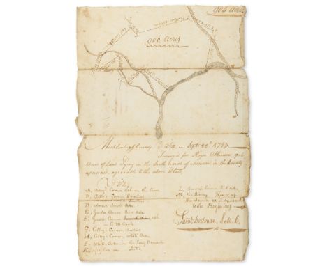
Surveying.- N[orden] (J[ohn]) The Surveyors Dialogue. Divided into five Bookes: Very profitable for all men to peruse, that have to do with the revenues of Land, or the manurance, use, or occupation thereof, both Lords and Tenants, first edition, a few woodcut diagrams, initials and decorations, initial leaf (blank except for signature "A") present but laid down, a few other marginal repairs, good margins, modern red morocco, spine faded, old vellum covers and spine bound in at end, [STC 18639; Kress 279], Printed [by Simon Stafford] for Hugh Astley, dwelling at S. Magnus corner, 1607.⁂ First edition of this work "important because of Norden's clear account of the operation of the court of survey and because of his efforts to reconcile the differences between surveyor and tenant." (A.W. Richeson, English land measuring to 1800, 1966).Rothamsted acquisition date not listed.
Lot 204
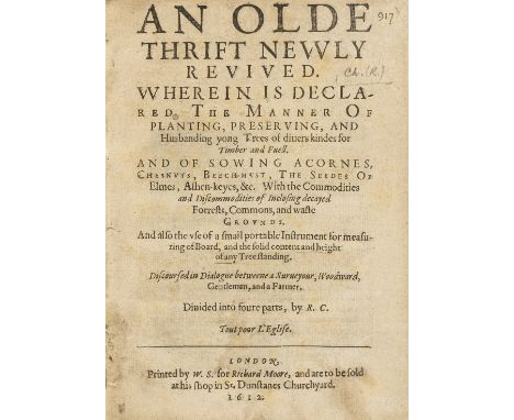
Trees.- Churche (Rooke) An Olde Thrift newly Revived. Wherein is Declared the Manner of Planting, Preserving, and Husbanding yong Trees of divers kindes for Timber and Fuell, first edition, largely printed in black letter, trimmed close in places, just touching headlines on occasions, occasional light foxing, folding woodcut plate, woodcut illustrations and diagrams, initial blank leaf present, later polished tan calf, gilt, by Riviere & Son, g.e., [STC 4923; Fussell I, p.33], small 4to, Printed by W.S. for Richard Moore, and are to be sold at his shop in St. Dunstanes Churchyard, 1612.⁂ Sometimes attributed to Robert Chambers and R. Churton, ESTC records 3 variants: this copy has "Surveyors are odious to Farmers" on D3, line 21. The work is written in the form of a dialogue between a surveyor, woodsman, gentleman and farmer.Rothamsted acquisition date not noted.
Lot 211
Surveying.- Rathborne (Aaron) The Surveyor in Foure bookes, first edition, fine engraved title by William Hole, 2 engraved portraits, that of the author cut and laid down as frontispiece, woodcut illustrations and diagrams, occasional light marginal water-staining, a few spots and marks, later calf, joints cracked, [STC 20748; Fussell I, pp.22-23], folio, by W. Stansby for W. Burre, 1616.⁂ The first comprehensive English textbook on surveying, the work is divided into four parts: Geometry; Problems in Geometry; the application of parts 1 and 2 to the measurement of land; and a legal section dealing with the problems of the manor.Rothamsted acquisition date not noted.
![Surveying.- [Leybourn (William)], "Oliver Wallinby". Planometria: or the Whole Art of Surveying of Land: Shewing the Composit](https://cdn.globalauctionplatform.com/95c463bf-8582-41f1-88eb-a8f900fdee7b/6b0a1941-0c7e-4177-8c93-e009240b6e7b/468x382.jpg)
Lot 271
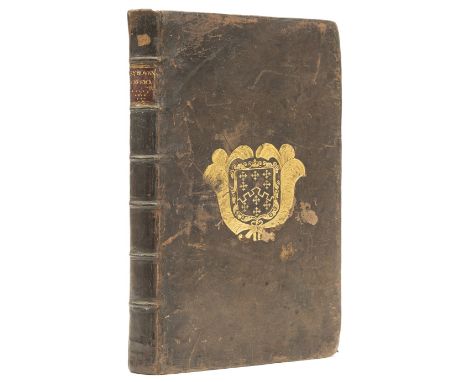
Surveying.- [Leybourn (William)], "Oliver Wallinby". Planometria: or the Whole Art of Surveying of Land: Shewing the Composition, and Use of All the Most Necessary Instruments thereunto Belonging, woodcut diagrams and illustrations including 3 full-page, woodcut diagram laid down on C1 as instructed, occasional light browning, ink ownership inscription to title, ink notes to front free endpaper, contemporary sheep, rubbed and scuffed, [Honeyman 2002; Wing L1928A], 8vo, Nathanael Brooke, 1650.⁂ Leybourne's scarce first work on surveying, this formed the basis of his better known The Compleat Surveyor, published in 1653. Provenance: Ch. Heveningham (ink ownership inscription).
Lot 276
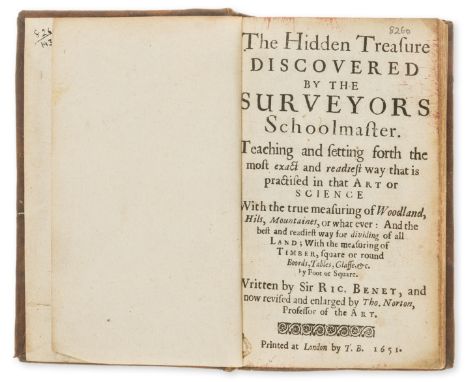
Education.- Benese (Richard) The Hidden Treasure Discovered by the Surveyor Schoolmaster... with the true measuring of woodland, hills, mountains or whatever and the best and readiest way for dividing of all land, revised and enlarged by Thomas Norton, woodcut diagrams in text, minor worming to foot of gutter, touching a few catch-words, contemporary calf, rebacked preserving original backstrip, [Wing B1867B], small 8vo, by T.B., 1651.⁂ Charming scarce work, only 5 copies listed on ESTC, no copies at auction in the last 50 years.
Lot 284
Surveying.- Leybourn (William) The Compleat Surveyor: Containing the whole Art of Surveying of Land, by the Plain Table, Theodolite, Circumferentor, and Peractor, first edition, engraved portrait frontispiece, title in red and black within typographic border, numerous woodcut illustrations and diagrams, foxing and soiling, one small burn-hole in text, I1 with circular piece cut from margin, affecting ruled border but not text, contemporary calf, worn, [Wing L1907], folio, Printed by R. and W. Leybourn, for E. Brewster and G. Sawbridge, 1653.⁂ Quite scarce at auction, the work was first issued under the pseudonym of Oliver Wallinby and under the title Planometria, or the Whole Art of Surveying Land, in 1650 (see lot 271). In 1666 Leybourn was one of six surveyors given the task of measuring the damage caused by the Great Fire of London.Provenance: Anthony Methwin (several ink inscriptions to endpapers, one at end dated 1669).
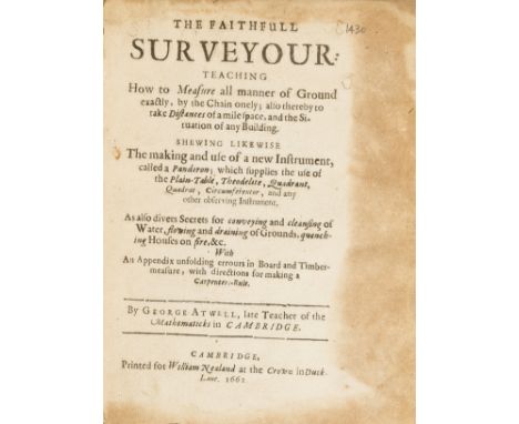
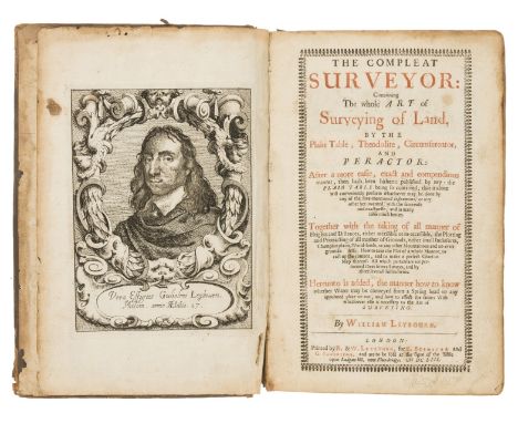
Lot 310
Surveying.- Atwell (George) The Faithfull Surveyour, second edition, woodcut diagrams, marginal browning at beginning and end, contemporary sheep, rubbed, [Wing A4164], Cambridge, Printed for William Nealand, 1662 § Leybourn (William) The Compleat Surveyor, second edition, engraved portrait frontispiece with short tear, title in red and black, woodcut illustrations and diagrams, stub of final blank leaf present, occasional soiling, contemporary sheep, spine worn at head and foot, scuffed, [Wing L1908], Printed by R. and W. Leybourn, for G. Sawbridge, 1657 § Norden (John) The Surveiors Dialogue, third edition, partially printed in black letter, some woodcut diagrams, last leaf with margin and corner cut away but not affecting text, endpapers and verso of final leaf with heavy contemporary ink annotations and calculations, contemporary limp vellum, lacking ties, [STC 18641], Printed by Thomas Snodham, 1618, 4to and folio (3)⁂ Three important 17th century titles on surveying, all in contemporary bindings.
Lot 24
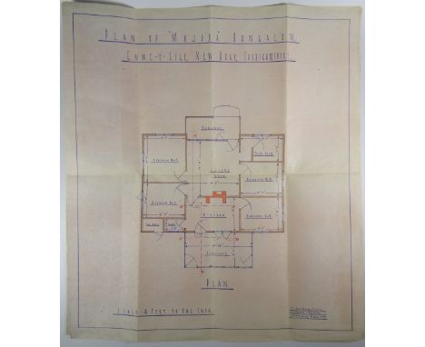
OF DYLAN THOMAS INTEREST - A PLAN OF MAJODA BUNGALOW WITH POLICEMAN'S NOTES relating to an infamous incident in New Quay, Ceredigion, of March 6th 1945; Captain Killick, a drinking pal of Dylan Thomas and a former Commando Officer on leave, shot his machine gun at the bungalow in which his friend and the poet's family were residing. The incident resulted in a court-case in Lampeter and was covered by National newspapers. It was characterised in the biographical film 'Edge of Love' (2008). According to 'The Dylan Thomas Trail' by David Thomas (Y Lolfa) '...at about 10.40pm Dylan was standing in front of the fire place in the living room at Majoda, telling Caitlin and friends about his scuffle in the Black Lion with William Killick. In Ffynonnfeddyg next door, Killick had also returned from the pub and was retrieving a Sten gun and hand grenade from his store of weapons, intent on giving Dylan and his party a taste of war'. It is believed that Captain Killick was seeking revenge for a complicated relationship that was ensuing with Dylan Thomas and the Captain's wife Vera Killick. He had just returned from 18 months' service behind enemy lines in Greece with the Special Operations Executive to find tongues wagging about an affair between his wife, Vera, and Thomas, with whom Thomas had grown up. To add insult to injury, the Captain's bank account was empty - plundered to support the Thomas' rackety lifestyle. The plan of the bungalow was commissioned by PC 21 Arthur Islwyn Williams, who was the local 'Bobby' and whom investigated the incident. On the reverse of the plan are PC Williams' notes in pencil with his observations at the scene noting the bullet-holes and the final location of the bullets '2 holes in glass pane outside scullery window 4-9 above ground level, 2 B/Holes in asbestos partition.....In transom of same door......asbestos partition nr. rt of same door......on the door of bedroom No 2....lodged in the right jamb of same door.....about 29in from wall of bedroom No 2...ceiling of living room facing the sea I found an embedded bullet...In the ceiling directly in line with the front door I noticed 6 bullet holes in the shape of a horse shoe....' The plan is in good condition with a scale of 4 feet to one inch, measuring 48 x 42cms and is attributed bottom right to J Lewis-Evans FIAA Architecture and Surveyor, Aberystwyth, March 1945', it has been folded into eight sections with two sections on the back inscribed with PC Williams' notes. Fortunately for Captain Killick he was acquitted of attempted murder at the subsequent trial. It is said that there was some sympathy in the local community for the former soldier who had seen active combat. To his friend and poet Vernon Watkins, Dylan Thomas wrote, 'Caitlin and I go to bed under the bed' Provenance: directly from the son of PC Williams now ironically living in the old police house in New Quay
Lot 179
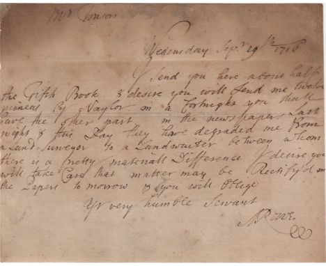
ROWE NICHOLAS: (1674-1718) English Dramatist, Poet Laureate 1715-1718. Rare A.L.S., N Rowe, one page, oblong 8vo, n.p., 29th September 1716, to Mr. [Jacob] Tonson. Rowes informs his correspondent, in full, 'I send you here about half the Fifth Book & desire you will send me twelve guineas by Naylor. In a fortnight you shall have the other part. in (sic) the newspapers last night & this day they have degraded me from a land-surveyor to a landwaiter between whom there is a pretty materiall difference. I desire you will take care that matter may be rectify'd in the papers to morrow & you will oblige.' A very neat trim to the left edge, only very slightly affecting the text, staining to the upper edge and overall light foxing, professionally silked. G Jacob Tonson (1655-1736) English Bookseller and Publisher, founder of the famous Kit-Cat Club, best known for having obtained a copyright on the plays of William Shakespeare.
Lot 59
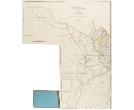
India.- Joseph (Charles) Map of the Grand Trunk Road from the Karamnassa to the Sutledge, Part Second, from Agra to Ferozepoor, large folding road map of one of the oldest and longest trade routes linking the Indian subcontinent with Central Asia, lithographed map with hand-colouring, 2270 x 1075 mm. (89 1/2 x 42 1/4 in), dissected and mounted on linen, some surface dirt and light abrasion, folding with blue endpapers into original cloth covered boards with publisher's label on upper cover, worn, oblong 4to, 1854⁂ Scarce. The present map is the second part published to accompany an earlier publication, in 1851, of the area between Agra and Benares. Little is known about Charles Joseph, but he appears to be listed as a surveyor in the Surveyor General's office.
Lot 133
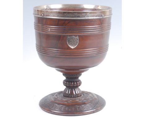
An 18th century lignum vitae wassail bowl, of ring turned cylindrical form, on a fluted column to further carved circular footrim, having later silver mount inscribed 'James Gascoigne Lynde born 25th January 1816', with further white metal shield shaped initialled cartouche, the silver band with makers mark for Elizabeth Eaton of London 1880, h.25cm, dia. 20cmJames Gascoigne Lynde (1816-1883) served his apprenticeship at Chelsea Waterworks Co, and later worked on several engineering projects including the burgeoning railway system, viaducts and bridges. He was a member of the Institute of Civil Engineers and was appointed City Surveyor of Manchester in 1859. Condition Report / Extra Information One pin with silver band missing. Small split to foot approx 2”. Old split to top of column. Minor age/handling wear.
Lot 126
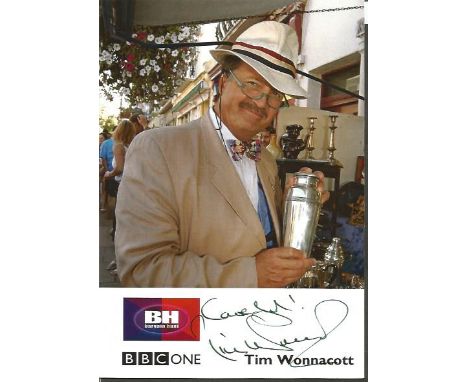
Tim Wonnacott 6x4 signed Bargain Hunt colour promo card. Timothy Wonnacott born 6 May 1951 is an English chartered auctioneer, chartered surveyor, antiques expert, and a television presenter. He was a director of Sotheby's, one of the world's oldest auction houses. Wonnacott is best known for presenting the BBC daytime programme Bargain Hunt from 2003 until 2015 and has been the narrator of Antiques Road Trip since it began in 2010. Good Condition. All signed items come with our certificate of authenticity. We combine postage on multiple winning lots and can ship worldwide. UK postage from £3.95, EU from £4.99, Overseas from £7.95
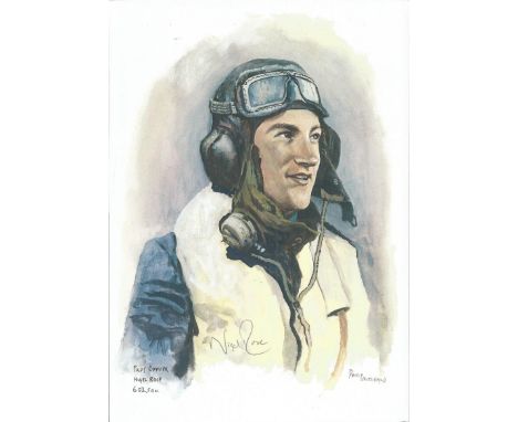
Lot 683
Plt/Off Nigel Rose WW2 RAF Battle of Britain Pilot signed colour print 12 x 8 inch signed in Pencil. Image of him in flying gear. Sqn Ldr Rose, who was training to be a quantity surveyor when war broke out, had joined the Royal Air Force Volunteer Reserve at Southampton in December 1938 as an airman under training pilot. After completing his training in June 1940, he was commissioned as a Pilot Officer and joined No 602 Squadron at Drem the next day. On 13 August he was thrown into the front line when the squadron moved to Westhampnett, a satellite of Tangmere. On one occasion, he found himself in trouble over the Channel after he was shot up by an ME 110 which he later explained had made rather a mess of the spitfire. He went on: At first I thought I had to get out. I put the hood back, undid the straps and got my feet up on the seat. But then I decided that I could get back to Westhampnett. I managed that and landed with no brakes, flaps or radio. After serving with No 54 Squadron and spending time as an instructor in the UK and the Middle East, Sqn Ldr Rose left the RAF in February 1946 and pursued his earlier choice of career, becoming a chartered quantity surveyor. Good Condition. All signed items come with our certificate of authenticity. We combine postage on multiple winning lots and can ship worldwide. UK postage from £3.95, EU from £4.99, Overseas from £7.95
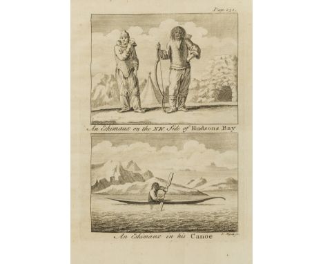
Lot 4
Americas.- Ellis (Henry) A Voyage to Hudson's-Bay, by the Dobbs Galley and California...for Discovering a North West Passage, first edition, folding engraved map, 9 engraved plates, 5 folding, list of subscribers to the expedition, occasional light soiling, contemporary ink inscription of Thomas Fane to front free endpaper, contemporary calf, rubbed, [Sabin 22312], 8vo, for H.Whitridge, 1748.⁂ Ellis was the surveyor on this voyage which proved, once and for all, that a North-West passage from Hudson's Bay did not exist. The work contains some of the earliest information on the customs of the Inuit.
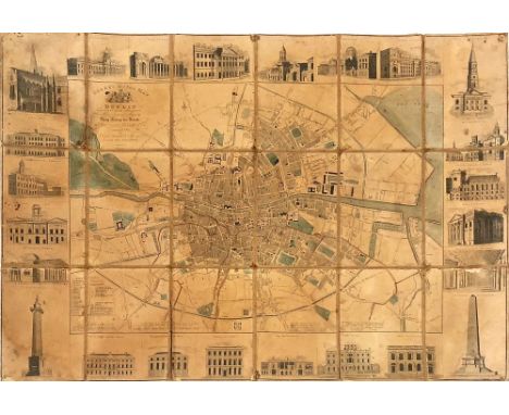
Lot 741
Map of Dublin with Attractive EngravingsIrish Map: Dublin - Cooke (J.) Arch & Surveyor Cooke's Royal Map of Dublin, dedicated by Special Permission to His Most Gracious Majesty King George the Fourth on His Visit to Ireland in August 1821, hand coloured, Dublin 1822, the border decorated with various engraved vignette of landmark buildings in the city, approx. 50cms x 72cms (20" x 28"), worn. Scarce. (1)
Lot 414
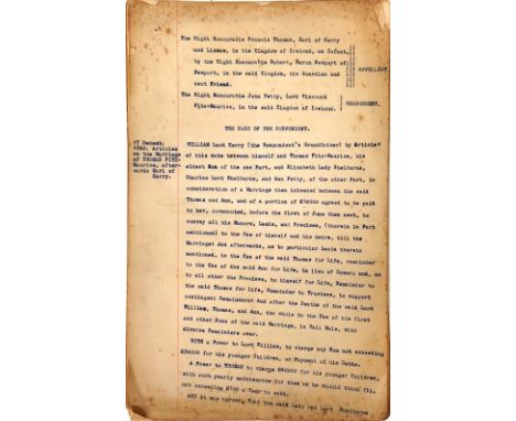
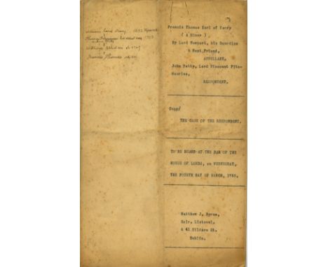
Typescript of a 1752 Court Case Regarding Lands in KerryCo. Kerry: Typescript (22 pp) of a case to be heard by the Irish House of Lords on 4 March 1752 between Francis Thomas, Earl of Kerry and Lixnaw, a minor, and John Petty, Viscount FitzMaurice.Thomas (FitzMaurice), 1st Earl of Kerry and Lixnaw, married in 1692 Anne Petty, daughter of the celebrated Sir William Petty, economist, scientist, philosopher and land surveyor. They had two sons: William, who succeeded his father in 1742, and John, who in 1751 inherited the estates of his maternal grandfather, changed his name to Petty, and was created Viscount FitzMaurice (he became Earl of Shelburne in 1753). William, 2nd Earl of Kerry, died in 1747 and was succeeded by his son Francis Thomas, then a young child. The law-suit is thus between a nephew and an uncle, John (the uncle) claiming money and lands under settlements made by his father the 1st Earl. In 1750 the court upheld his claim, but the nephew (through his guardian) appealed the case to the House of Lords. In this document, John demands that the original judgement be upheld.John's insistence was caused in part by the fact that under Earl Thomas's management the Kerry estate had greatly increased in value, with the construction of a mansion, deer park, gardens, fruit and forest plantations, and encouragements to tenants to improve their lands (see p. 13).An important legal document illustrating the complexities of Irish land ownership, the feudings within a prominent family, and the development of a Kerry estate, in the first half of the 18th century. As a typescript. (1)
Lot 8
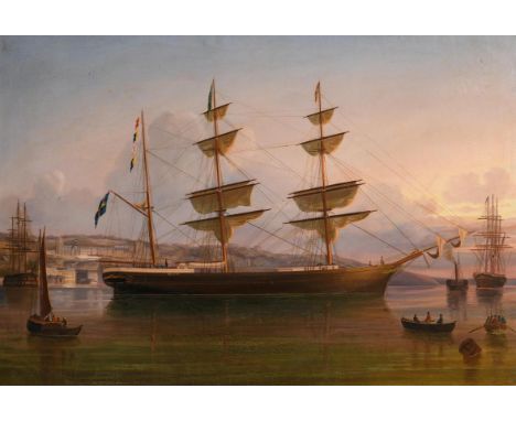
George Mounsey Atkinson (1850-1908) The Eugenie Off Queenstown oil on canvas title inscribed lower left 61 x 89½cm (24.02 x 35.24in) Private Collection A self-taught artist, as Government Surveyor of Shipping and Emigrants at Queenstown, now Cobh, Atkinson was ideally located to capture his favourite subjects - the elegant sailing ships docking under his nose.
Lot 115
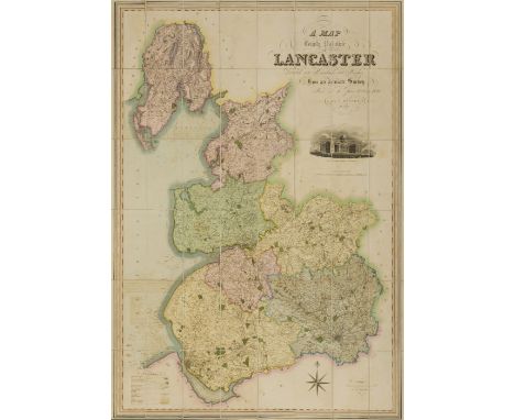
NO RESERVE Lancashire.- Hennet (George, surveyor) A Map of the County Palatine of Lancaster, large map with ornate title upper right, vignette view of the New Custom House, Liverpool, just below, engraved map by James Bingley, with bright original hand-colouring, 1630 x 1160 mm. (64 1/4 x 45 3/4 in), dissected and mounted on linen, edged with green silk, very slight offsetting and browning, minor surface dirt, folding with green marbled endpapers, presented in tree calf book-style slipcase, rubbed, spine with red morocco label gilt-lettered 'Teesdales Map of Lancashire', 4to, Henry Teesdale, 1830.
Lot 2125
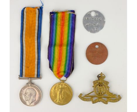
WWl pair to 3159 SJT. R S Jones 12-LOND. R.with a dog tag for Jones R.S. H 5602 with medal bar, Protection & Disembodiment Certs. Xmas 1914 tin, a Soldier's Service Book and dog tag for 1083026 S R Jones with Royal Artillery, Surveyor & Indian Infantry patches, RA cap bage Army Prayer Book, Burmese Phrase Book, 107 Batt. Comedy programe and a 1945 South East Asia Demob letter Condition Report Click here for further images, condition, auction times & delivery costs
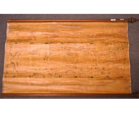
Lot 17
A wall hanging scroll, the New Burial Ground Charminster, Dorset, by J Feacey, Architect and Surveyor, Dorchester, linen backed, approx 59 x 99 cm Condition report Report by RBThe pine rods lack to end finials, has been rolled and unrolled for a number of years, its cracked, some ink crossing through to the plots
Lot 3
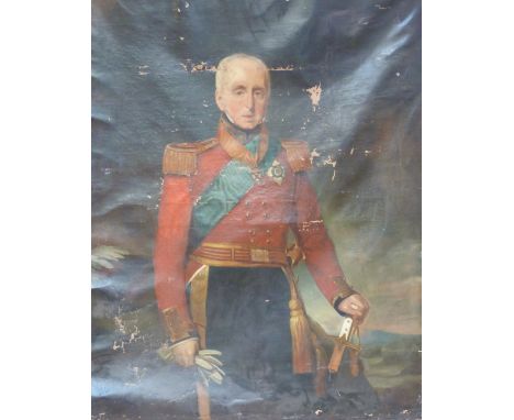
A large 19thC three-quarter length oil on canvas portrait of Lt General Sir Rufane Shaw Donkin, GCH KCB FRS FRGS (1772-1841) in full regalia with his hand on an ivory-handled Mughal/Indian sword, wearing Knight of the Garter insignia and the Guelphic Order. CE Clifford, Artist Colourman No 30 Picadilly, London verso, 140cm x 110cm.Lt General Sir Rufane Shaw Donkin had a distinguished military and civil career, having served in the West Indies (1793) and Pophams' expedition to Ostende (1798) with Cathcart in Denmark (1807) and Wellington in the Peninsula. He was Quartermaster General to the Mediterranean from 1810-1813 and was posted to India in 1815. After the army, Donkin's life was spent in literary and political work, he was one of the original Fellows of the Royal Geographical Society, MP for Berwick-on-Tweed (1832-1837) and in 1835 he became Surveyor General of the Ordnance. He was MP for Sandwich in 1839 until his death on 1st May 1841.
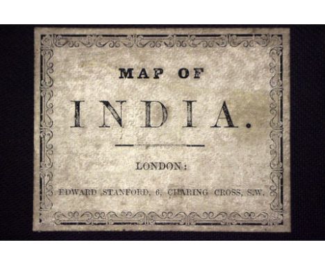
Lot 911
'Map of India 1881', hand-coloured 19th-century linen-backed map in four parts (North East, South East, South West, North West), with decorative marbled paper and original labels. Complete with original slipcase bearing label for Edward Stanford of London. 'Published under the direction of Lieut. General J. T. Walker, Surveyor General of India, Surveyor General's Office, Calcutta, November 1881'. The map records the original price: 'Uncolored Six Rupees, Colored Eight Rupees'. Produced on a scale of one inch to 32 miles. Printed from a transfer from copperplate with additions on stone. British Raj interest.
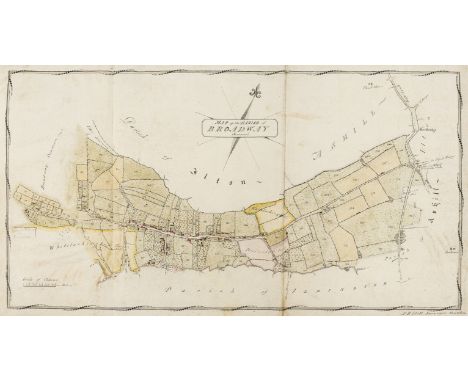
Lot 10
Somerset Estate Maps.- Ilett (P.B., surveyor, of Taunton) Map of the Parish of Broadway Somerset, 380 x 655mm., n.d. [c. 1820s]; Map of the Forest Grounds and Broadway Common... Copied from a Survey made by Mr Chilcott, 670 x 680mm., 1823, manuscript watercolour estate maps on vellum, folds, soiled and browned; and 3 others, Broadway area, v.s., v.d. (5).⁂ Broadway, near Ilminster.
![Dialling.- [Martindale (Adam, nonconformist minister and mathematics instructor, 1623-86)] A description of a plaine instrume](https://cdn.globalauctionplatform.com/b6934ccb-7922-4e2b-a95a-a88f00e27afa/34d29ab4-3ebe-46fb-fdef-21513271d6bb/468x382.jpg)
Lot 146
Dialling.- [Martindale (Adam, nonconformist minister and mathematics instructor, 1623-86)] A description of a plaine instrument, that with much ease and exactness will discover the situation of any vertical plane, howsoever inclining, reclining, or declining, and how to draw a diall upon any such plane, or upon the face of any vertical body how irregular soever, together with several other things requiset to the arte of dialling, manuscript, 14pp. [ESTC cites 2 copies only of this work], [c. 1670] bound with [Leybourn (William, mathematician and land surveyor, 1626-1716)] The Art of dialling Arithmetically performed: By the Canons; or Tables of Artificiall sines & Tangents, manuscript, 22pp., [c. 1670], bound in reverse order, 3 pen and ink drawings of dials, some ff. loose, browned, unbound.⁂ "In 1668... [Martindale] published The Description of a Plain Instrument, in which he described the uses of a scientific instrument designed for geometric and navigational measurement." - Oxford DNB.
Lot 148
Kent Estate Map.- Brazier (John, surveyor) A Plan of Bradbourn Farm in the Parishes of Sevenoaks and Otford Kent belonging to Sir Chas. Farnaby Radcliffe Bart., manuscript watercolour estate map on vellum, foxed, browned and slightly creased, on wooden battens at head and tail, 570 x 380mm., 1702.⁂ Bradbourne, near the village of East Malling, Kent.
Lot 112
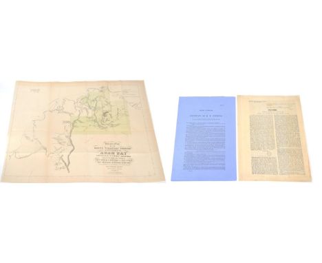
South Australia Tenders for Survey in Northern Territory, together with Report on Same by Surveyor-General, Ordered by the House of Assembly to be Printed, 20th October, 1868, eight pages plus two plans, one of which is; Bennett (J.W.O.) & Finniss (B.T.), Sketch Map of the Northern Territory Country in the Vicinity of Adam Bay ... Showing approximately the tracks of the various explorers ... and the locality of the Gold Producing District discovered by Mr F.H. Litchfield in September 1865, sheet 570mm x 630mm [cf. Jones's Ochre and Rust, page 141-2]; Finnis (B.T.), Petition of B.T. Finniss, printed 28th September 1866, six pages, disbound; [B.T. Finniss was the first Premier of South Australia] Vice Admiralty Court of Victoria, Decree, relating to a Shipping Claim between the Steamships 'Kanowna' and 'Glaucus', 1907, 4 pages (3)
Lot 402
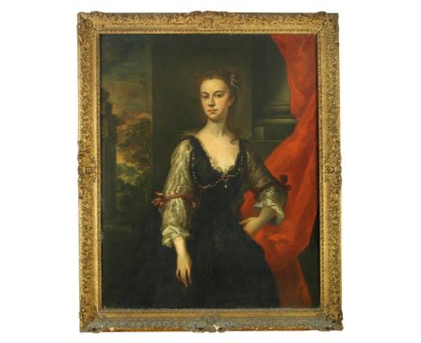
Studio of John Vanderbank (British, 1694-1739) Portrait, said to be Elizabeth, Countess of Pembroke, circa 1740, three-quarter length, standing, wearing pearls in her hair and a ruby and pearl necklace, before a red drapery and a distant landscape oil on canvas 125 x 100cm (49 x 39in) Provenance: Westacre High House, Norfolk, and by descent to the present owner Literature: Prince Frederick Duleep Singh, Portraits in Norfolk Houses, Norwich: Jarrold and Sons, 1928, Volume II, p.379, No. 29, where given erroneously as "Elizabeth Herbert, Countess of Pembroke, 1737" Other Notes: The sitter is traditionally said to be Elizabeth, Countess of Pembroke (see Literature). If, however, the sitter is a Countess of Pembroke, from the date of the painting and their respective dates, it can only be either the Hon. Mary Howe (died 1749), third wife of the 8th Earl of Pembroke, who, after his death, married the Hon. John Mordaunt, or the Hon. Mary Fitzwilliam, wife of the 9th Earl of Pembroke, who after his sudden death, married Major North Ludlow Bernard. Sir Oliver Millar, Surveyor of the Queen's Pictures, confirmed the attribution to Vanderbank in April 1961. Slightly over-cleaned. Oil on canvas which has been lined and attached onto a new strecher. The canvas tension is good and the picture is in plane. The paint layer is in a good, stable condition. There is some retouching in the sitter's face which lies under the varnish. The varnish is very yellowed, dull and uneven. There is a layer of surface dirt present. (Inscription - the Duchess of Cleveland verso) - circa 1740.
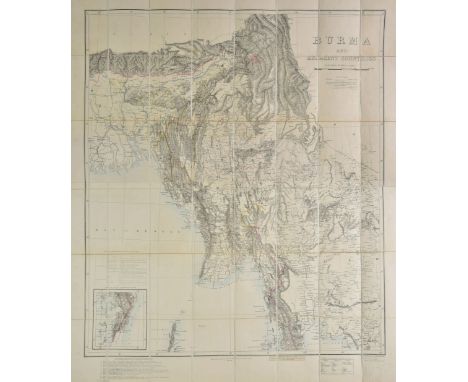
Lot 148
Burma. Philip (George & Son, publisher), Burma and adjacent countries, published under the direction of Col. H. R. Thuillier R. E., Surveyor General of India, 1890, lithographic map with sparse contemporary outline colouring, sectionalised and laid on linen, 1100 x 895 mm, marbled endpapers, contained in a contemporary cloth slipcase with printed label to upper board, slipcase a little faded (1)
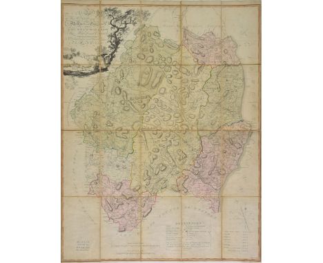
Lot 174
Ireland. Nevill (A. R., surveyor), To the Rte. Honble. and Honble. The Noblemen and Gentlemen of the County of Wicklow, This Map of said County, taken from actual surveys is dedicated by their most humble servant..., published Wm. Allen, Dublin, circa 1790, engraved map by John McKinley Taylor, sectionalised and laid on linen, contemporary hand colouring, compass rose and table of references, some dust and finger soiling, a few small abraided holes to linen along old folds, bookplates of P. & A. Shaw to outer covers, 900 x 705 mm Uncommon. (1)
Lot 363
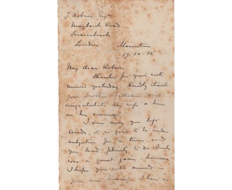
GORDON CHARLES GEORGE: (1833-1885) British Army officer, known as Chinese Gordon. A.L.S., C.G. Gordon, two pages, 8vo, Mauritius, 17th October 1881, to John Robson. Gordon sends congratulations on Robson's brothers' marriage, and continues, 'I am sorry you left Airds, it is good to be under subjection for a time, and you had plenty to do which was a great gain. However, I hope you will succeed in your new business. I have no idea who I could introduce you to in the W[ar].O[ffice] I do not even know the surveyor... I expect anyone can tender.' A rare letter from Gordon's short tenure in Mauritius. With light overall foxing, otherwise G John Robson came into Gordon's circle in the 1860's while still a schoolboy, and later became his pupil as the first step in an engineering career. In April 1881 Gordon left for Mauritius as Commander, Royal Engineers. He remained there until March 1882.
Lot 145
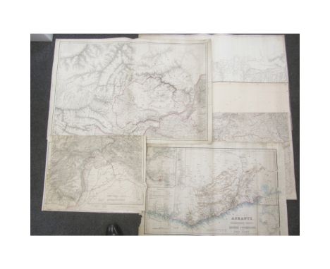
Maps, India & elsewhere including - Capt. J.T. Walker.District Peshawar & parts of districts Kohat, Rawul Pindee & Hazara, with Buneyr, Swat, Kabul & Terah. (No. 14) John Walker, 1860, double page engraved map, hand-coloured in outline, 638 x 970mm., several tears on E. side repaired on verso; similar map, imprint cropped, showing Kabul, 638 x 970mm., one tear repaired on verso; Mansell, Lt. A.L. Famagousta. Admiralty, 1878, lithographed map, 632 x 485mm., folds, short tear lower left; Wyld, James Wyld's Map of Ashanti and Neighbouring States with the British Possessions on the Gold Coast. 1873, double page coloured map, 512 x 794mm., 2 tears repaired on verso with minimal loss, some spotting; Punjab Map, Section 1, 2 (of 8), Calcutta, Surveyor General's Office, 1867, 556 x 962mm., hand-coloured in outline; Wyld, James Wyld's Military Staff Map of Central Asia and Afghanistan. [c. 1870 ?], 4 sheets (possibly once joined), each sheet 44 x 58cm.; sold not subject to returnProvenance: The property of the Newbattle Abbey College Trust
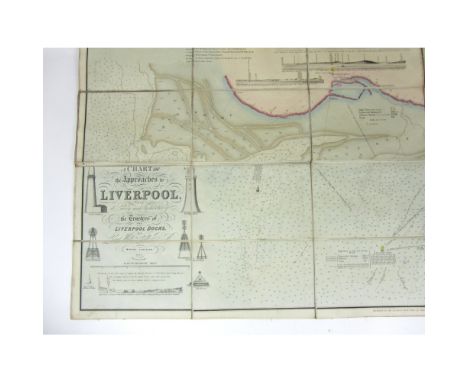
Lot 515
Liverpool - Liverpool Dock TrustA chart of the approaches to Liverpool from a survey made by direction of the Trustees of the Liverpool Docks by Lieut. William Lord RN Marine Surveyor. London: J. & C. Walker, 1852. 124 x 147cm. Engraved, hand coloured chart on 48 linen backed sheetsNote: Scale: circa 1:19,000. Chart showing the area from Formby Point southwards to the eastern branch of the Dee. Illustrations and positions of the following given: lighthouses, lightships, beacons, buoys. Notes on tide levels and sailing directions. Originally issued with a slip case.
Lot 37
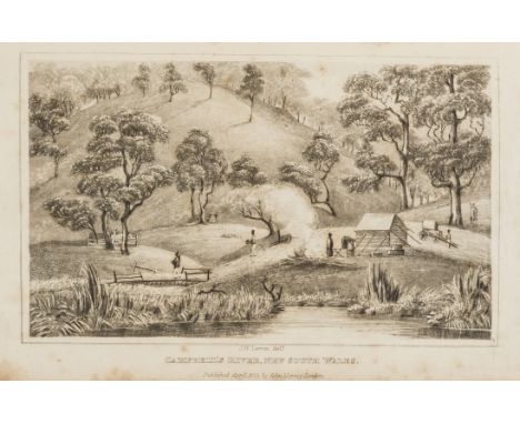
Australasia.- Australia.- Field (Barron) Geographical Memoirs on New South Wales; by Various Hands..., first edition, 4 folding engraved maps, 3 engraved plates (one aquatint view of Campbell river after J.W.Lewin and 2 botanical), maps and plates a little foxed and offset, contemporary half calf, spine gilt with red morocco label, a little rubbed, [Abbey, Travel 571; Ferguson 1009; Wantrup 108], 8vo, 1825.⁂ Important collection of works on the exploration of New South Wales, edited by a judge of the Supreme Court, and including Surveyor-General John Oxley's 'Report of an Expedition to Survey Port Curtis, Moreton Bay, and Port Bowen, with a view to form Convict Penal Establishments there', on which he discovered the Brisbane River and selected the site of the future city of Brisbane (not separately published). Also including John Uniacke's account of the same expedition, the only published account of Allan Cunningham's 'Journal of a Route from Bathust to Liverpool Plains...', Field's 'On the Aborigines of New Holland and Van Diemen's Land' and 'On the Rivers of New South Wales' across the Blue Mountains, Capt. Mark Currie's 'Journal of an Excursion to the southward of Lake George in New South Wales', and the first trade publication of 'First Fruits of Australian Poetry' (the first book of poems published in Australia, previously only issued privately, Sydney, 1819), as well as others on the aborigines and timber, geology and meteorology etc. of the area.
Lot 46
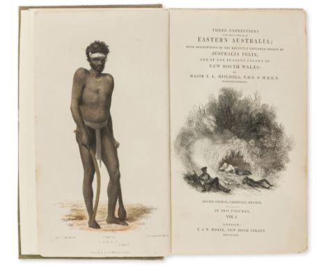
Australasia.- Australia.- Mitchell (Sir Thomas Livingstone) Three Expeditions into the Interior of Eastern Australia; with descriptions of...Australia Felix , and of the present colony of New South Wales, 2 vol., second edition, titles with wood-engraved vignettes, folding engraved map hand-coloured in outline in pocket at beginning of vol.1, 51 plates and maps, most lithographed, some hand-coloured, a few folding, vol.1 with 8pp. 'Opinions of the Press' bound before text rather than at beginning (soiled) and 16pp. publisher's catalogue at end, occasional light foxing or soiling, folding map with a few short tears to folds, second issue binding of original blind-stamped green cloth, spines gilt with titles and kangaroos, emus and boomerangs, rubbed and lightly stained, spines faded, new endpapers, [Ferguson 2811; Wantrup 125], 8vo, 1839. ⁂ Account of expeditions into the interior of Australia by the Surveyor General of New South Wales, and containing important information on aboriginal life.
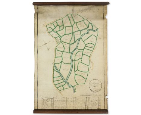
Lot 144
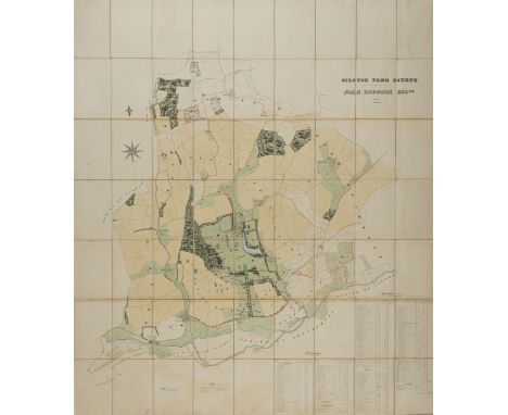
Hertfordshire Estate Map.- Adams (Charles F., surveyor, of Bartway, Hertfordshire) Gilston Park Estate, the Property of John Hodgson Esq., large folding hand-coloured manuscript estate map, reference key, mounted on linen, original black straight-grained morocco case, gilt, one side split, 185.5 x 155cm., 1851.⁂ John Hodgson was a wealthy shipbroker who purchased this extensive estate in 1850 and proceeded to alter it dramatically in his thirty year ownership. This map shows the area before the changes.
Lot 768
A pair of Eight Horses of Mu Wang bowls, marks of Jiajing, mid 17th century, of flared conical form, the eighth horse within, 17.5cm diameter (2)Provenance: Edward Newcombe, born in 1843, the son of William Lister Newcombe, General Manager of the Midland Railway Company. Edward worked for the same company as his father until his wedding in 1873. He had taken a job as a surveyor to work on the construction of railways in Japan, for the Meiji government. Three years later his contract expired and he won an appointment in the surveyor general's office in Hong Kong. The family were well off and able to afford luxuries, including Japanese and Chinese porcelain, which they brought back to the UK just a few months later.condition: hairlines to both, chips to rim and foot of one
Lot 769
A Blanc de Chine, whiteware tripod censer, with a frieze of archaistic characters in relief, with reticulated hardwood lid, 17cm high with lidProvenance: Edward Newcombe, born in 1843, the son of William Lister Newcombe, General Manager of the Midland Railway Company. Edward worked for the same company as his father until his wedding in 1873. He had taken a job as a surveyor to work on the construction of railways in Japan, for the Meiji government. Three years later his contract expired and he won an appointment in the surveyor general's office in Hong Kong. The family were well off and able to afford luxuries, including Japanese and Chinese porcelain, which they brought back to the UK just a few months later.condition: hairlines and crazing, repair to handle, lid broken and part missing
Lot 770
A pair of lime green ground bowls, Daoguang marks and probably of the period, each exterior embellished with scattered and overlapping medallions under the vivid enamel glaze, the interiors painted in underglaze blue with a "white rabbit grazing" medallion centring four flower sprays, 15cm diameter (2)Provenance: Edward Newcombe, born in 1843, the son of William Lister Newcombe, General Manager of the Midland Railway Company. Edward worked for the same company as his father until his wedding in 1873. He had taken a job as a surveyor to work on the construction of railways in Japan, for the Meiji government. Three years later his contract expired and he won an appointment in the surveyor general's office in Hong Kong. The family were well off and able to afford luxuries, including Japanese and Chinese porcelain, which they brought back to the UK just a few months later.
Lot 771
An 18th Century Chinese bowl, reeded form with landscape enamels to the exterior and interior, 22cm diameterProvenance: Edward Newcombe, born in 1843, the son of William Lister Newcombe, General Manager of the Midland Railway Company. Edward worked for the same company as his father until his wedding in 1873. He had taken a job as a surveyor to work on the construction of railways in Japan, for the Meiji government. Three years later his contract expired and he won an appointment in the surveyor general's office in Hong Kong. The family were well off and able to afford luxuries, including Japanese and Chinese porcelain, which they brought back to the UK just a few months later.condition: hairline to base, small chips to rim
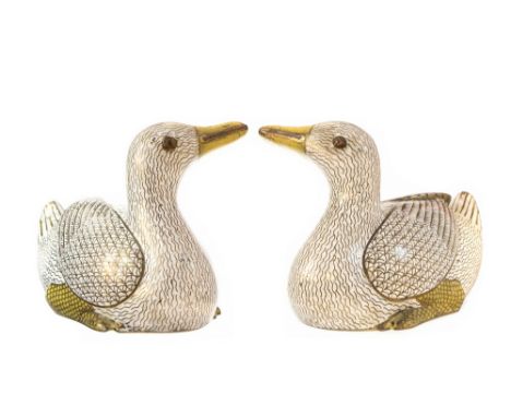
Lot 798
A pair of Chinese cloisonné Ducks, white enamel on brass, modelled in sitting pose (2)Provenance: Edward Newcombe, born in 1843, the son of William Lister Newcombe, General Manager of the Midland Railway Company. Edward worked for the same company as his father until his wedding in 1873. He had taken a job as a surveyor to work on the construction of railways in Japan, for the Meiji government. Three years later his contract expired and he won an appointment in the surveyor general's office in Hong Kong. The family were well off and able to afford luxuries, including Japanese and Chinese porcelain, which they brought back to the UK just a few months later.
Lot 169
Leybourn (William) The Compleat Surveyor, fourth edition, title in red and black, engraved portrait by R. White (portrait margin torn laid down) and 6 folding engraved plates, F4 small hole affecting page no., some staining in corners becoming more pronounced towards end, slightly browned, ink signature on title, new endpapers, modern half calf, gilt, [Wing L1910], E. Flesher for George Sawbridge, 1679.
Lot 59
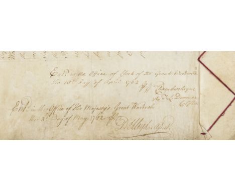
George III and the Great Wardrobe.- George III (King of the United Kingdom of Great Britain and Ireland, and King of Hanover, 1738-1820) Warrant Dormant addressed to Earl Gower, Master of the Great Wardrobe for Liveries to... Thomas Worlsey. Esq., Surveyor General... Henry Flitcroft Esq., Comptroller... Henry Hastings, Page of the Bedchamber... William Hastings, Page of the Presence..., D.s. "George R" at head of first sheet, manuscript on vellum, 2 sheets, folds, yellowed, lacks seal, 560 x 700mm. and 500 x 700mm., 3rd May 1762.⁂ The Great Wardrobe was responsible for expenditure on clothing, textiles, furs, spices, and other domestic items. It was abolished by the Civil List and Secret Service Money Act 1782.
![Attractive Manuscript Estate Map[1798] Roe (John) surveyor, A Map of the Demesne of Sir Edward B. Littlehales Bart. in the Ph](https://cdn.globalauctionplatform.com/7a8ea991-1c32-47c1-980c-a82000b965a8/92530822-34ba-45fe-dd68-430ff1bfbfec/468x382.jpg)
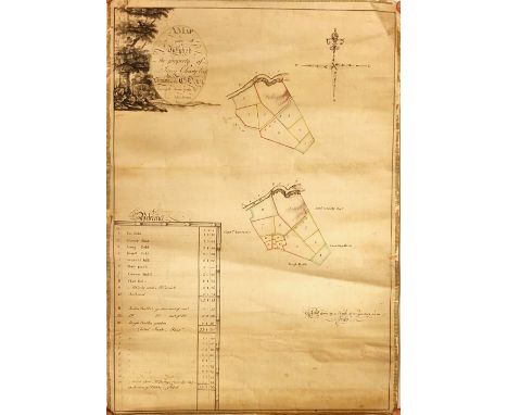
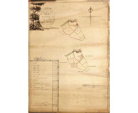
Lot 490
Attractive Manuscript Estate Map[1798] Roe (John) surveyor, A Map of the Demesne of Sir Edward B. Littlehales Bart. in the Phoenix Park, July 1809. a large colourful drawing, with 'Reference' key, approx. 36cms x 62cms (14" x 24 1/2"), two small sections of blank border torn away. As a drawing, w.a.f. (1)* N.B. Sir E.B. Littleholes came to Ireland in 1799 as Secretary to Lord Cornwallis, and after 1800 stayed on as Military Under-Secretary at Dublin Castle till his retirement in 1818. (1)
Lot 424
Typescript of a 1752 Court Case Regarding Lands in KerryCo. Kerry: Typescript (22 pp) of a case to be heard by the Irish House of Lords on 4 March 1752 between Francis Thomas, Earl of Kerry and Lixnaw, a minor, and John Petty, Viscount FitzMaurice.Thomas (FitzMaurice), 1st Earl of Kerry and Lixnaw, married in 1692 Anne Petty, daughter of the celebrated Sir William Petty, economist, scientist, philosopher and land surveyor. They had two sons: William, who succeeded his father in 1742, and John, who in 1751 inherited the estates of his maternal grandfather, changed his name to Petty, and was created Viscount FitzMaurice (he became Earl of Shelburne in 1753). William, 2nd Earl of Kerry, died in 1747 and was succeeded by his son Francis Thomas, then a young child. The law-suit is thus between a nephew and an uncle, John (the uncle) claiming money and lands under settlements made by his father the 1st Earl. In 1750 the court upheld his claim, but the nephew (through his guardian) appealed the case to the House of Lords. In this document, John demands that the original judgement be upheld.John's insistence was caused in part by the fact that under Earl Thomas's management the Kerry estate had greatly increased in value, with the construction of a mansion, deer park, gardens, fruit and forest plantations, and encouragements to tenants to improve their lands (see p. 13).An important legal document illustrating the complexities of Irish land ownership, the feuding's within a prominent family, and the development of a Kerry estate, in the first half of the 18th century, as a typescript. (1)
-
1532 item(s)/page