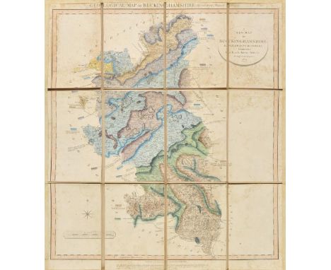

Buckinghamshire. Cary (John), A New Map of Buckinghamshire. Divided into Hundreds, Exhibiting its Roads, Rivers, Parks &c. [with secondary title above map] Geological Map of Buckinghamshire by W.S.Smith, Mineral Surveyor, 1824, engraved maps with contemporary hand colouring, sectionalised and laid on linen, some staining, margins strengthened on recto with old tape, 600 x 510 mm, contemporary blind stamped sheep boards with gilt title to upper siding, retaining old silk ties, worn and heavily frayed with slight loss at corners, together with, Stephenson (John), An Actual Survey of the Coast of Kent from Dim Church to Rye Harbour with the New Shoal to the Westward of Dungeness by John Stephenson a Master in the Royal Navy, published Robert Sayer, 1787, uncoloured engraved chart with two horizon profiles, old folds, 490 x 695 mm (2)
We found 1532 price guide item(s) matching your search
There are 1532 lots that match your search criteria. Subscribe now to get instant access to the full price guide service.
Click here to subscribe- List
- Grid
-
1532 item(s)/page
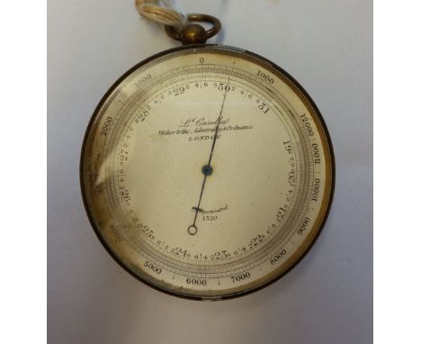
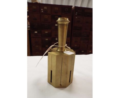
A Brass Pocket Barometer By L Casella, Maker to the Admiralty & Ordnance London. *The Barometer was given to James Conroy by Waldyve Wellington St. George in the early 1900's while stationed in the Curragh. James Conroy served as a surveyor in New Westminster British Colombia Canada. It was left in James Nolans pub in 1914 and over the years, because it was so accurate, the local farmers would cut the hay by its reading. "It was nothing to do with it being in a pub".
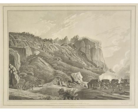
Colebrooke (Robert Hyde). Twelve Views of Places in the Kingdom of Mysore, the Country of Tippoo Sultan, from drawings taken on the spot. To which are annexed, concise descriptions of the places drawn, with a brief detail of part of the operations of the army under the Marquis of Cornwallis, during the late war, and a few other particulars, 1st edition, 1793, printed title, dedication leaf, 12 uncoloured aquatint plates by J.W. Edy after R.H. Colebrooke, each with accompanying leaf of letterpress description, single-sheet list of subscribers at rear, title with some light soiling and marginal fraying, relined, with central horizontal repaired tear, and lower outer blank corner missing, short closed tear repair to centre of foremargin of dedication leaf and first two text leaves and plates (not affecting image), a few minor marginal marks and small marginal repairs towards rear of volume, final plate with light central vertical crease, list of subscribers, with one or two marginal closed tears (repaired), late 19th or early 20th-century cloth gilt, with printed label of the Royal United Service Institution to front pastedown, rubbed and some marks and soiling, spine partly defective, large oblong folio (550 x 705mm) Abbey, Travel 419. Tooley 149. First edition of these scenic views of the southern kingdom of Mysore in India, etched in aquatint by the engraver John William Edy after drawings by the surveyor Robert Hyde Colebrooke (1762-1808), produced in the aftermath of the Third Mysore War, following which Tippoo Sultan handed over parts of the region, various forts, and a significant financial settlement to the East India Company. The prints are titled: East View of Bangalore, The Lake of Mooty Tallaow near Seringapatam, Prospect of the Country near Mooty Tallaow, Pagodas at Maugry with a distant View of Sewandroog, N.W. View of Nandydroog, North View of Sewandroog shewing the Attack in Decr. 1791, South View of Sewandroog, S.W. View of Ootra-Durgum, West View of Ramgherry, The Mausoleum of Hyder Aly Khan at Laulbaug, East View of Seringapatam & N.W. View of Seringapatam. (1)
Mitchell (Thomas Livingstone). Three Expeditions into the Interior of Eatern Australia; with Descriptions of the Recently Explored Region of Australia Felix, and of the Present Colony of New South Wales, 2 vols., 2nd ed. carefully revised, 1839, title with wood-engraved vignettes, 50 lithographed plates and charts, including seven coloured (one or two close-trimmed affecting imprint), large folding map (neat repairs), single-page colour map, a few minor spots, blindstamps to titles, modern olive half sprinkled calf, spines with red labels, slightly faded, 8vo Ferguson 2811. Account of Surveyor-General Mitchell's three expeditions to determine the courses of the large rivers in Southern Australia and is of ethnographic value with its detailed descriptions of Aboriginal life, as well as geology, topography and natural history. (2)
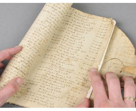
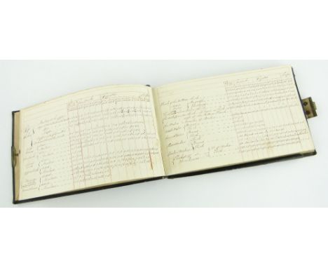
*Leicestershire Manuscript Survey. A manuscript survey entitled 'An Exact and Perfect Survey of the Lordship of Bringhurst in the County of Leicester, being taken and admeasured by the Purch of 16. 1/2. foot, according to the Statute. De Terris mensurandis, by Vincent Wing Supervisor, Octob: 1658', ink on paper, 11 leaves (half-title, title, text, final 2 leaves blank), half-title torn with loss and laid down, large tear to title affecting blank areas and border only, several text leaves torn across without loss and leaves strengthened on foremargins, stitched and rolled in a contemporary vellum sheet with original ties intact, contemporary manuscript surveying notes to vellum inner surface, 4to (text leaves 20 x 15cm unrolled) Vincent Wing (1619-1668), English astrologer, astronomer and land surveyor. Born in North Luffenham, Rutland, he was a highly accomplished mathematician and by the age of 20 he was already a professional land surveyor, almanac-maker and astrologer. He is now chiefly remembered as an astronomer and was notable as a champion of the new astronomical systems of Copernicus and Tycho Brahe. However, it was mostly through his work as a land surveyor that he made his living and, in 1664, he published 'The Art of Surveying'. This manuscript survey gives a rare insight into his practices and presentation of his work. It refers to an open plan field system with the strips of land held by various tenants; a mixture of freehold and copyhold, as the land in Bringhurst was not enclosed until 1804. Tenant names include Sir John Norwich (freehold land) and Richard Green (freehold and copyhold land). Although a few of his maps are known to have survived, no other of his land surveys have been located. (1)
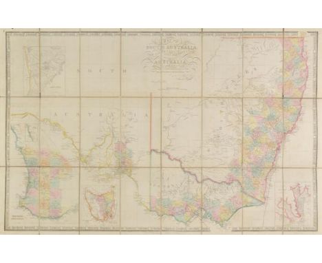
Australia. Wyld (James), Map of South Australia, New South Wales, Van Diemens Land and Settled parts of Australia, Respectfully dedicated to Major T.K.Mitchell..., Surveyor General of New South Wales, published Jas. Wyld, circa 1850, engraved map with contemporary outline colouring, sectionalised and laid on linen, inset maps of Sydney, Adelaide and Van Diemens Land, some splits along old folds, slight staining, 620 x 965 mm (1)
Field (Barron, ed.). Geographical Memoirs on New South Wales; by Various Hands: Containing an Account of the Surveyor General's Late Expedition to Two New Ports; the Discovery of Moreton Bay River, with the Adventures for Seven Months there of two Shipwrecked Men; a Route from Bathurst to Liverpool Plains; Together with Other Papers on the Aborigines, the Geology, the Botany, the Timber, the Astronomy, and the Meteorology of New South Wales and Van Diemen's Land, 1st ed., 1825, uncoloured aquatint frontispiece, four folding maps, two botanical plates, some light marginal waterstains, occasional light soiling and crease marks, untrimmed, modern half calf, slight fading and small indentation to upper cover, 8vo Ferguson 1009. Contains early accounts of explorations and expeditions in Eastern Australia, including Oxley's expedition to Port Curtis and Moreton Bay, and the only published account of Allan Cunningham's exploration from Bathurst to the Liverpool Plains. (1)
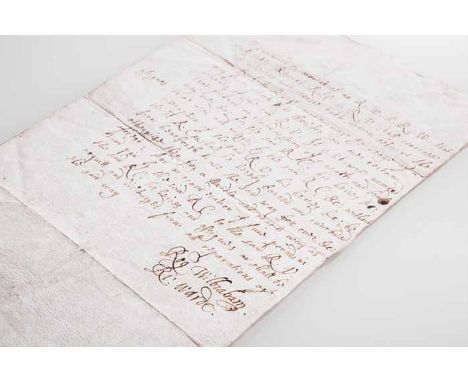
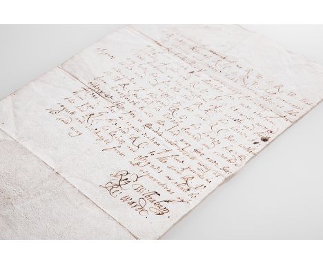
LATE 16TH CENTURY POLITICAL INTEREST LETTER signed by Sir Richard Warde (died 1578) and Sir Roger Wilbraham (1553 - 1616), it appears to be a letter discussing the promises and terms connected to an agreement or argument over the property of an 'R.C' and 'R.V' which these two men where either witness too or facilitaing; together with another later letter, probably 19th century, which discusses the position of bishops to affect the morality of the people in their diocese and to stay true to the path of their faith rather than furthering thier own causes, possibly a daft to be used as a surmon or speech, these two letters are loose inside a half morocco leather folio that originally contained a group of Civil War Broadsides, a label to the inside cover shows the folio and it's original contents were sold at Sothebys, July 9th 1923 Lot 151 for five pounds, ex libris Fairfax of Cameron label to inside cover, also with a dealer's receipt dated 1915 from Maggs Brothers, 109 Strand, London, for a list of civil war period documents, some may have made up the broadsides later contained within the folio, folio 39.5cm long Note: Sir Richard Warde was an English politician and Royal Official. In 1571, during the reign of Elizabeth I of England, he was elected the Member of Parliament for Berkshire, due to the support of Henry Norris, 1st Baron Norreys. He was also MP for Windsor a number of times, as well as being Cofferer of the Royal Household and Clerk of the Green Cloth. Sir Roger Wilbraham was a prominent English lawyer who served as Solicitor-General for Ireland under Elizabeth I and held positions at court under James I, including Master of Requests and surveyor of the Court of Wards and Liveries. He bought an estate at Dorfold in the parish of Acton (later his son built Dorfold Hall on the site which still stands today) near his birthplace of Nantwich.

LATE 16TH CENTURY POLITICAL INTEREST LETTER signed by Sir Richard Warde (died 1578) and Sir Roger Wilbraham (1553 - 1616), it appears to be a letter discussing the promises and terms connected to an agreement or argument over the property of an 'R.C' and 'R.V' which these two men where either witness too or facilitaing; together with another later letter, probably 19th century, which discusses the position of bishops to affect the morality of the people in their diocese and to stay true to the path of their faith rather than furthering thier own causes, possibly a daft to be used as a surmon or speech, these two letters are loose inside a half morocco leather folio that originally contained a group of Civil War Broadsides, a label to the inside cover shows the folio and it's original contents were sold at Sothebys, July 9th 1923 Lot 151 for five pounds, ex libris Fairfax of Cameron label to inside cover, also with a dealer's receipt dated 1915 from Maggs Brothers, 109 Strand, London, for a list of civil war period documents, some may have made up the broadsides later contained within the folio, folio 39.5cm long Note: Sir Richard Warde was an English politician and Royal Official. In 1571, during the reign of Elizabeth I of England, he was elected the Member of Parliament for Berkshire, due to the support of Henry Norris, 1st Baron Norreys. He was also MP for Windsor a number of times, as well as being Cofferer of the Royal Household and Clerk of the Green Cloth. Sir Roger Wilbraham was a prominent English lawyer who served as Solicitor-General for Ireland under Elizabeth I and held positions at court under James I, including Master of Requests and surveyor of the Court of Wards and Liveries. He bought an estate at Dorfold in the parish of Acton (later his son built Dorfold Hall on the site which still stands today) near his birthplace of Nantwich.
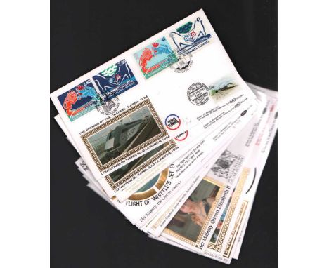
Benham Cover Collection. 50 unsigned Benham covers with good postmarks, all Unaddressed and in very good condition. Includes 1994 Channel Tunnel Opening pair of covers - Calais/Folkestone, 1994 25th Anniversary of the Investiture of the Prince of Wales, 1990 90th Birthday of the Queen Mother, 1994 British Open, 1991 Canine Defence League, 1992 World Wildlife Fund, 1992 40th Anniversary of the Accession, 1991 Darling Buds of May, 1991 Rugby Union World Cup, 1991 25th Anniversary of the Surveyor 1 Space Mission, 1993 Adventures of Sherlock Holmes, 1989 Children's Toys and Games, 1990 150th Anniversary of the Universal 1d Post, 1990 RSPCA 150th Anniversary, 1990 Printers of the Penny Black, 1987 British Architects and many more. All in Good condition. All signed items come with COA and guarantee of authenticity. Can be shipped worldwide.
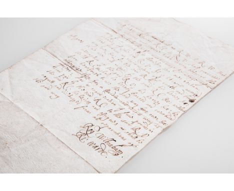
LATE 16TH CENTURY POLITICAL INTEREST LETTER signed by Sir Richard Warde (died 1578) and Sir Roger Wilbraham (1553 - 1616), it appears to be a letter discussing the promises and terms connected to an agreement or argument over the property of an 'R.C' and 'R.V' which these two men where either witness too or facilitaing; together with another later letter, probably 19th century, which discusses the position of bishops to affect the morality of the people in their diocese and to stay true to the path of their faith rather than furthering thier own causes, possibly a daft to be used as a surmon or speech, these two letters are loose inside a half morocco leather folio that originally contained a group of Civil War Broadsides, a label to the inside cover shows the folio and it's original contents were sold at Sothebys, July 9th 1923 Lot 151 for five pounds, ex libris Fairfax of Cameron label to inside cover, also with a dealer's receipt dated 1915 from Maggs Brothers, 109 Strand, London, for a list of civil war period documents, some may have made up the broadsides later contained within the folio, folio 39.5cm long Note: Sir Richard Warde was an English politician and Royal Official. In 1571, during the reign of Elizabeth I of England, he was elected the Member of Parliament for Berkshire, due to the support of Henry Norris, 1st Baron Norreys. He was also MP for Windsor a number of times, as well as being Cofferer of the Royal Household and Clerk of the Green Cloth. Sir Roger Wilbraham was a prominent English lawyer who served as Solicitor-General for Ireland under Elizabeth I and held positions at court under James I, including Master of Requests and surveyor of the Court of Wards and Liveries. He bought an estate at Dorfold in the parish of Acton (later his son built Dorfold Hall on the site which still stands today) near his birthplace of Nantwich.
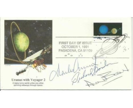
Apollo 12 Crew Signed FDC Charles Conrad, Richard Gordon & Alan Bean signed Apollo 12 FDC. Apollo 12 was the sixth manned flight in the United States Apollo program and the second to land on the Moon (an H type mission). It was launched on November 14, 1969 from the Kennedy Space Centre, Florida, and four months after Apollo 11. Mission commander Charles Pete Conrad and Lunar Module Pilot Alan L. Bean performed just over one day and seven hours of lunar surface activity while Command Module Pilot Richard F. Gordon remained in lunar orbit. The landing site for the mission was located in the south eastern portion of the Ocean of Storms. Unlike the first landing on Apollo 11, Conrad and Bean achieved a precise landing at their expected location, the site of the Surveyor 3 unmanned probe, which had landed on April 20, 1967. They carried the first colour television camera to the lunar surface on an Apollo flight, but transmission was lost after Bean accidentally destroyed the camera by pointing it at the Sun. On one of two moonwalks, they visited the Surveyor and removed some parts for return to Earth. The mission ended on November 24 with a successful splashdown. Good condition. Item comes with lifetime guarantee of authenticity and COA from an AFTAL registered dealer.
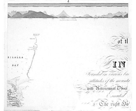
William BaldMayo, Map of the maritime County Mayo in Ireland.Founded on various bases and trigonometrical operations, exhibiting barometrical altitudes of the mountains, the levels and depths of the bogs and lakes; with Astronomical Observations, Physical Sections and Profiles of the Country; Executed by order of the Grand Jury. The Right Honourable Denis Brown M.P. and Member of the Dublin Society, and Royal Irish Academy, foreman; Commenced in 1809, and terminated in 1817, by William Bald F.R.S.E. Member of the Royal Geographical Society Paris, Member of the Geological Society London, Member of the Royal Irish Academy, Honorary Member of the Wernerian Natural History Society Edinburgh. Engraved by Pierre Tardieu, 1830. overall dimensions when joined. 3.11m x 2.57m average sheet size 620 x 510By William Bald, a massively detailed map of Mayo in 25 sections, each varying slightly in size; a little detail here and there of adjacent counties. Large title cartouche. Extensive table of mountain heights. Lake levels; bog levels and depths. Coastal soundings. Plan of trigonometrical base lines. Scale 1 inches to 1 mile. Published by the Mayo Grand Jury. Some edges frayed and some light foxing otherwise in very good condition. William Bald was born in Burntisland in 1789. He was employed as an apprentice under the celebrated Scottish surveyor, engraver and mapmaker, John Ainslie. Bald made a survey of Harris in 1805 when he was only 16, and was later responsible for surveys of ~Benbecula, south Ulst, Eriskey and Argyll, possibly because the tugged nature of the terrain would have been difficult for Ainslie, then in his 60s. These and other of his surveys were later incorporated into Aaron Arrowsmith's map of Scotland. By the time Bald arrived in Mayo in 1809 as county surveyor, he had been described by his teacher and mentor John Ainslie as a very big man... In the words of John Andrews, no ordinary tribute for a twenty-year-old. Bald's first commitment in Mayo was a Grand Jury map of the county. At the same time, he managed to work for the Bogs Commission on their brief for a survey of the bogs of Ireland. Both surveys were to degree of sophistication and meticulousness which far outstripped anything known in Ireland up to that time. His map of Mayo was unique in its scale and scholarship. The base measurement and triangulation were impeccable. Bald spent 18 years on the Mayo survey and engaged Pierre Tardieu in Paris, the foremost engraver of his day, to bring the map to fruition. This was done very slowly and at great expense, finally reaching the light of day in 1830. Bald was a familiar figure in Castlebar, much admired by some, yet disliked by others who through envy of his great expertise, carped at his efforts; or who, unused to the sheer cost of mapping on such a scale, complained at his lavish use of public money. Bald went on to plan surveys of Clare and Down. He even envisaged a general triangulation of Ireland and a new geological map. He still found time to attend to roads and bridges in his adopted county. The coming of the Ordnance Survey spelled the end of the era of the great land surveyors, Bald among them. In later life, he concentrated on roads, bridges, canals and harbours, and eventually railways. He was a principal adviser in the early deliberations of the Ordnance Survey. William Bald loved Mayo, as can be seen from his Map. The profusion of place names, particularly coastal place names, attests to his love of the Mayo landscape, so like his native Scotland. He was one of the ablest, most hard-working and most creative map-makers ever to practise in Ireland. He died in 1857; he is buried in Highgate Cemetery, London. His wife, Anne, pre-deceased him; she is buried in Straide, Co. Mayo.
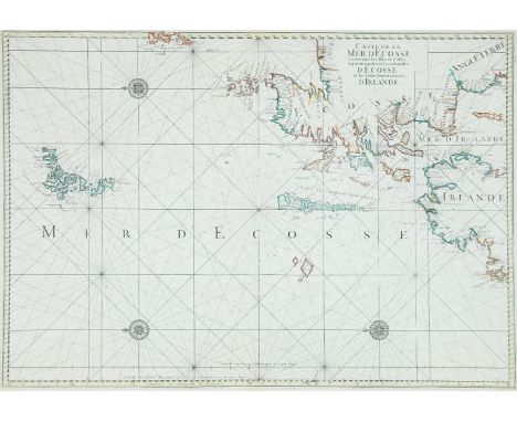
Pene, Charles (fl. 1679)A Chart of Northern Ireland and Scotland (1693)“Carte de la Mer d`Ecosse Contenant les Isles et Costes Septentrionales et Occidentales d`Ecosse et les Costes Septentrionales d`Irlande.” Watermark “BYCOLOMBIER” (1693). 870 x 605.Surveyor and cartographer, original editor of the great volume of charts called Le Neptune Francois, published in 1693. Three charts of the Irish coast, originally from Le Neptune Francois but in various editions and states.
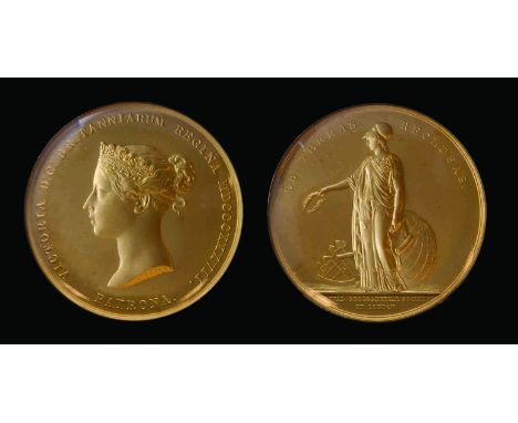
The Royal Geographical Society’s Victoria Medal awarded to Colonel Sidney Gerald Burrard, K.C.S.I., Royal Engineers, Surveyor of India, for his work on the Topography of the Himalayas (including Everest) in 1913 and who was considered ‘the eminent, member of the Community of Surveyors of the Empire’, together with his Baronet’s Badge, comprising: (i) Royal Geographical Society, Victoria Medal, in gold, by W. Wyon, young head of Queen Victoria, rev. the draped figure of Athena standing holding a wreath and map, at her feet a globe and sextant (Colonel S.G. Burrard, C.S.I., R.E., F.R.S. 1913), 55.5mm, 131g all in, glazed with gold rim, in original fitted Wyon case of issue (Eimer 1229); (ii) Baronet’s Badge, United Kingdom type, in silver-gilt and enamels (Burrard of Walhampton 3 April 1769), hallmarked London, 1935, in original Royal Mint case of issue, two tiny marks to glass near edge of the first, extremely fine (2) NOTE: C.S.I.: London Gazette, 12 December 1911: ‘Coronation Honours’; K.S.C.I.: London Gazette, 22 June 1914: ‘Royal Engineers, Surveyor-General in India’; 1913: S. G. Burrard Indian Survey - ‘For his distinguished contributions to geography and geodesy.’ Colonel Sidney Gerald Burrard (1860-1943) was born at Yarmouth on the Isle of Wight, and was the eldest son of Lieutenant Colonel Sidney Burrard of the Grenadier Guards. After being educated at Uppingham and at Wellington College he was sent to Woolwich to join the Royal Engineers. He was a talented Cadet, particularly in Mathematics, receiving his first commission in April 1879. He sailed for India in 1882, and spent two years at Roorkee at the Head Quarters of the Bengal Sappers and Miners, before joining the Survey of India in September 1884. In this role he performed important work in accurately calculating and revising longitudes in India, and establishing tidal observatories at either end of the Suez canal, but it was in his work as Superintendent of the Trigonometrical Survey in Calcutta from 1899 onwards that he performed much of his greatest work. Written in collaboration with Sir Henry Hayden, Director of the Geological Survey of India, he wrote the book ‘A Sketch of the Geography and Geology of the Himalayan Mountains and Tibet.’ This work published a mine of hitherto unknown information regarding the Himalayas, including names, heights of peaks, classification into ranges, rivers, glaciers, lakes etc. In 1911, Burrard was made Surveyor-General of India in 1911, and was made C.S.I. at the Durbar in Delhi. In 1907 he had become a Fellow of the Royal Geographical Society and in 1913 he was awarded the Victoria Medal. The President of the Society, Lord Curzon, commented at the presentation: “There is not a scientific explorer of our time who has not consulted and in some measure been guided by Colonel Burrard, and there has not been a Surveyor-General of equal scientific attainments since the days of Everest.” He was later made K.S.C.I. in 1914, and continued an extended tenure as Surveyor-General until the end of WWI, retiring in 1919.
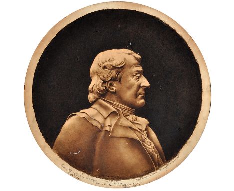
John J*** Miller (late 19th Century) A BUST PORTRAIT OF NICOLAS LEBLANC signed and inscribed "From a small photograph. Painted by John J. Miller, Surveyor and Draughtsman, Newcastle Chemical Works, Gateshead for Tyneside Chemical Industry Exhibition Showcase, Royal Jubilee Exhibition Newcastle on Tyne 1887. sepia 55cms; 21 1/2in. circular, mounted on board, unframed.
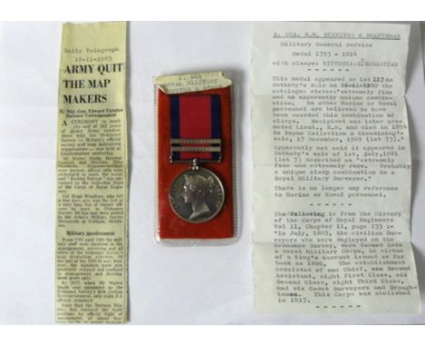
A.Rea Royal Marines Surveyor and Draftsman Military General Service Medal 1793-1814. With bars for St Sebastian and Vittoria, this medal appeared as lot 117 in Sotheby`s sale on 26/11/1980 the catalogues states"extremeley fine and an apparently unique combination.no other Marine or Naval personnel are believed to have been awarded this combination of clasps.recipient was later promoted Lieut.,R.M. and died in 1854 Ex Payne collection & Glendining`s sale 17 dec 1969 (lot 73)" Apparently not sold it appeared in Sotheby`s sale of 1st of July 1981 (lot 7) described as "extremely rare and fine probably a unique clasp combination ro a Royal Military Surveyor" there is no longer any reference to Marine or Naval personnel. a very rare and unusual medal in extremely fine condition with original ribbon as well as new replacement and cutting of the medals history so far.
Literature: "POSTAGE STAMP ISSUE FOR THE HEJAZ", "A Short Note on the Design and Issue of Postage Stamps Prepared by the Survey of Egypt for His Highness Husein Emir & Sherif of Mecca & King of the Hejaz" attributed to T. E. Lawrence (later 'Lawrence of Arabia') printed and published by 'Survey of Egypt and Government Press Cairo' in 1918, an original volume with white cardboard covers (7½" x 11") decorated with a printed arabesque motif in green. A fine unnumbered example of the 200 copies printed of this extremely rare book, itself very attractive and describes in detail the aspects of the stamp production process with all pages intact. Covers with a few small stain spots only mentioned for accuracy. All nine stamps intact on the frontispiece followed by the text by 'E. M. Dowson' then the twelve plates and folding table, dedicated to 'James H. Cole' a surveyor working in Egypt/Sudan at the time. Offered on behalf of the grandson of Mr. Cole. One of the most respected and desirable volumes of philatelic literature.
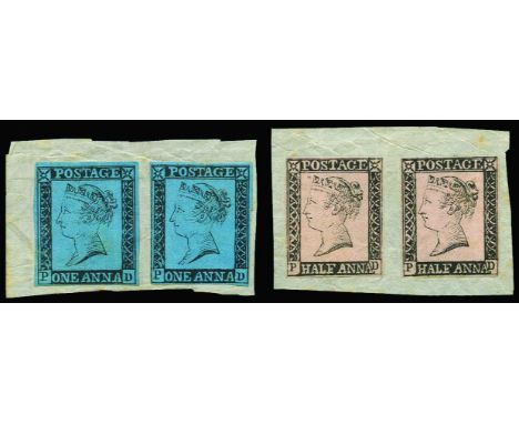
1854 (February)? Group of Thullier(?) lithographed essays, comprising 'POSTAGE HALF ANNA' (black on salmon) and 'POSTAGE ONE ANNA' (black on blue) designs of Queen Victoria (24 x 20mm), two of each value affixed to small pieces, also similar values and colours but circular designs showing a "Coat of Arms", Half Anna and One Anna (2) again affixed to small pieces, fine and very rare, not being known to Spence, and only discovered in 1980. (See "The Philatelist" Dec 1980). In 1853 it was decided that Indian stamps should be printed in India rather than London, and Col. Forbes (the Superintendent of the machinery at the mint in Calcutta) was consulted to produce such stamps. Subsequently it was deemed that his design (the Lion and Palm Tree) could only be printed singly and therefore the mint was unable to supply the approximate number (25million) required in sufficient time. This led to Captain Thullier (Deputy Surveyor General, Calcutta) being commissioned to prepare stamp designs for half, one, four and eight Anna stamps. Amonst the designs/essay not chosen were the circular design which was based on the East India 1pice coin bearing the Arms of Great Britain, and the rectangular design which was based on the Great Britain 1840 1d black and 2d blue issued stamps, the idea for these possibly came after Lord Dalhousie expressed a view that the stamps should be of a simple design with the Coat of Arms and Queen's head.
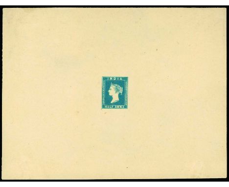
Half Anna - Proposed designs with the head of Queen Victoria: 1854 Lithographed impression of the essay submitted by Capt. Thullier, Half Anna blue on yellowish wove paper (Spence 69) complete sheetlet (140 x 110mm) with m/s " Given me by Sir Sidney Burrard/Surveyor General" and initialled in pencil on reverse, fine and scarce
Meon Valley.- - Wright Survey and Valuation of the Parish of Droxford in the... Wright (H.C., surveyor and valuer, fl. 1832) Survey and Valuation of the Parish of Droxford in the County of Hants: Descriptive of the Farms, Owners and Occupiers thereof together with the Woods, Mansions, Tenements and Tithes for the purpose of Equalizing the Parochial Assessments, manuscript, 126pp., ruled in red, new endpapers, modern half calf, old gilt morocco label on upper cover, folio, 1832.

LATE 16TH CENTURY POLITICAL INTEREST LETTER signed by Sir Richard Warde (died 1578) and Sir Roger Wilbraham (1553 - 1616), it appears to be a letter discussing the promises and terms connected to an agreement or argument over the property of an 'R.C' and 'R.V' which these two men where either witness too or facilitaing; together with another later letter, probably 19th century, which discusses the position of bishops to affect the morality of the people in their diocese and to stay true to the path of their faith rather than furthering thier own causes, possibly a daft to be used as a surmon or speech, these two letters are loose inside a half morocco leather folio that originally contained a group of Civil War Broadsides, a label to the inside cover shows the folio and it's original contents were sold at Sothebys, July 9th 1923 Lot 151 for five pounds, ex libris Fairfax of Cameron label to inside cover, also with a dealer's receipt dated 1915 from Maggs Brothers, 109 Strand, London, for a list of civil war period documents, some may have made up the broadsides later contained within the folio, folio 39.5cm long Note: Sir Richard Warde was an English politician and Royal Official. In 1571, during the reign of Elizabeth I of England, he was elected the Member of Parliament for Berkshire, due to the support of Henry Norris, 1st Baron Norreys. He was also MP for Windsor a number of times, as well as being Cofferer of the Royal Household and Clerk of the Green Cloth. Sir Roger Wilbraham was a prominent English lawyer who served as Solicitor-General for Ireland under Elizabeth I and held positions at court under James I, including Master of Requests and surveyor of the Court of Wards and Liveries. He bought an estate at Dorfold in the parish of Acton (later his son built Dorfold Hall on the site which still stands today) near his birthplace of Nantwich.

LATE 16TH CENTURY POLITICAL INTEREST LETTER signed by Sir Richard Warde (died 1578) and Sir Roger Wilbraham (1553 - 1616), it appears to be a letter discussing the promises and terms connected to an argeement or argument over the property of an 'R.C' and 'R.V' which these two men where either witness too or facilitaing; together with another later letter, probably 19th century, which discusses the position of bishops to affect the morality of the people in their diocese and to stay true to the path of their faith rather than furthering thier own causes, possibly a daft to be used as a surmon or speech, these two letters are loose inside a half morocco leather folio that originally contained a group of Civil War Broadsides, a label to the inside cover shows the folio and it's original contents were sold at Sothebys, July 9th 1923 Lot 151 for five pounds, ex libris Fairfax of Cameron label to inside cover, also with a dealer's receipt dated 1915 from Maggs Brothers, 109 Strand, London, for a list of civil war period documents, some may have made up the broadsides later contained within the folio, folio 39.5cm long Note: Sir Richard Warde was an English politician and Royal Official. In 1571, during the reign of Elizabeth I of England, he was elected the Member of Parliament for Berkshire, due to the support of Henry Norris, 1st Baron Norreys. He was also MP for Windsor a number of times, as well as being Cofferer of the Royal Household and Clerk of the Green Cloth. Sir Roger Wilbraham was a prominent English lawyer who served as Solicitor-General for Ireland under Elizabeth I and held positions at court under James I, including Master of Requests and surveyor of the Court of Wards and Liveries. He bought an estate at Dorfold in the parish of Acton (later his son built Dorfold Hall on the site which still stands today) near his birthplace of Nantwich.
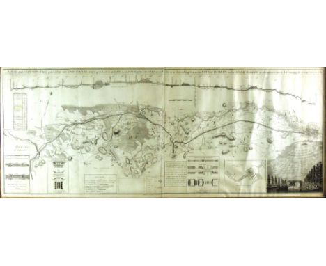
The Grand Canal, 1788 Co. Kildare & Dublin: Brownrigg (J.) Surveyor & Publisher, "A Map & Section of that Part of The Grand Canal now perfected and also a Sketch of the Country on each Side etc etc. Extending from The City of Dublin to the River Barrow at Monasterevan," engraved by J. Ford, Essex Quay, with fine engd. vignette, and inset sections etc., approx. 54cms x 136cms (21 1/2" x 53 1/2"), in hogarth type frame. (1) Fine Extremely Scarce.
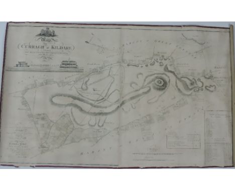
Rare Map of The Curragh Co. Kildare: Walker (Henry) Surveyor. "A Map of the Curragh of Kildare" showing The Race Courses Gentlemen's Seats etc. Accurately described. Dedicated to The Duke of Leinster and engraved by Kersting, approx. 69ms x 114cms (27" x 45"), with engd. views of The Stand etc., gilt frame. V. Rare. (1)
SANDERSON (GEORGE) MAP OF THE COUNTY OF NOTTINGHAM FROM A CAREFUL SURVEY MADE IN THE YEARS 1834 & 1835....BY THE PROPRIETOR GEO SANDERSON, SURVEYOR scale 0.5inch:1 mile, hand coloured engraving by J & C Walker, with vignette of Welbeck Abbey, backed on linen on two sheets with maroon cloth boards and NORTH and SOUTH labels, 141 x 216cm in gilt and blind tooled maroon morocco slip case, spine gilt, 1836

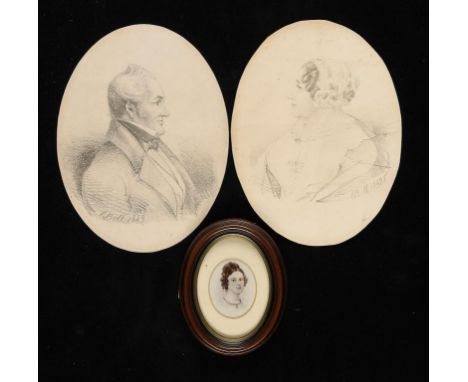
BY AND AFTER CHARLES DAVIDSON BELL, FRSE (1813-1882) PORTRAITS OF THE HON JOHN BARDWELL EBDEN OF EKELENBURG, RODENBOSCH, CAPE COLONY AND HIS WIFE ENID BELL SANDERS, NÉE HOPKINS TWO, LITHOGRAPHS 1849, OVAL, 24 X 18CM, A VICTORIAN PHOTOGRAPH OF A MINIATURE OF THEIR DAUGHTER MARTHA ANTOINETTE EBDEN AT ABOUT THE TIME OF HER MARRIAGE TO CHARLES DAVIDSON BELL AND A SMALL GROUP OF OTHER PRINTS AND PHOTOGRAPHS MAINLY OF MEMBERS OF THE BRODIE FAMILY. THE LITHOGRAPHS OF PENCIL DRAWINGS BY BELL WOULD APPEAR TO BE EXTREMELY RARE AND WERE PRESUMABLY PRINTED IN THE COLONY. CHARLES DAVIDSON BELL WAS THE FIRST SURVEYOR GENERAL IN THE CAPE COLONY AND AN ACCOMPLISHED ARTIST, WHO DESIGNED BY THE FAMOUS TRIANGULAR CAPE OF GOOD HOPE POSTAGE STAMPS. HE MARRIED, AS HIS FIRST WIFE, ON 3RD JUNE 1841 MARTHA ANTOINETTE EBDEN BY WHOM HE HAD THREE CHILDREN BEFORE DIVORCING HER IN 1850 ON THE GROUNDS OF HER ADULTERY WITH DR LESTOCK WILSON STEWART.
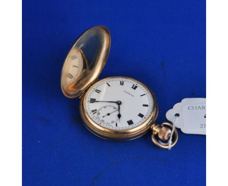
A 9ct gold hunter pocket watch, the white dial with Roman numerals and subsidiary seconds dial signed Stayte Condition report Report by GH The case has some small dents, scratches and wear. The glass has been replaced with a plastic piece which is detached from the face. The face itself has two very light hairline cracks. The watch ticks when wound and appears to be working. There is an inscription in the back of the case reading 'Presented to F L Gibson by the County Surveyor and Staff, Barnstaple, August 1926' Charterhouse does not guarantee the working condition of any watches or clocks.
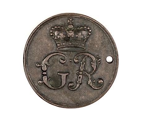
King’s Road Chelsea: an interesting AE pass, obverse: crown above GR; reverse: rosette above “The King’s Private Roads 17 RA 31”, diameter 30mm, pierced for suspension. GVF Plate 2 Note: The RA probably refers to Richard Arundell who was Surveyor of the King’s Private Roads 1731-1737 (and Master of the Mint 1737-1744). The route was originally used by Charles II who closed it to public transport; by the time of George II members of the public could pay for a pass to use the route. It is stated that this road was George III’s favourite route down to Kew. It ceased to be a Private Road in 1830.
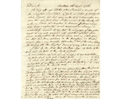
SMEATON JOHN: (1724-1792) English Civil Engineer who was responsible for the design of bridges, canals, harbours and lighthouses including the Eddystone Lighthouse (1755-59). A.L.S., J. Smeaton, two pages, 4to, Austhorpe, 22nd August 1786, to Dr. [Charles] Blagden at Whitby. Smeaton states that he has received a minute of the Longitude and Latitude of York, remarking that he looks upon it ‘as the best determination we have had: and York being pretty central to the County; and so far as I have had occasion to examine Jeffereys Large map, being a reasonably exact topographical survey, it immediately occurred to me that the Longitude of this place might be very well compared with what had resulted from former determinations: the best of which was, as I told you, one that had been put down in the Connoisance de temps deduced from a very accurate observation I had of the suns eclipse the morning after the Transn. Of Venus of 1769, which was 5’, 43” ‘ , continuing to provide his calculations for Austhorpe and explaining that they agree better with his own observations than those of the French, commenting on the effect that the recent weather has had on his observations, ‘I kept my letter open in hopes to have got a transit of the sun; to have ascertained the going of the clock since the 16th and this morning afforded some transitory gleams….and then came on a great black cloud….’ In a lengthy postscript Smeaton refers to his correspondent’s visit to the Pier and works at Whitby, where he should meet Mr. Pickernell, the engineer, remarking ‘I recommended him to the trustees upon the merit of his having acquitted himself, not only to my own, but every ones satisfaction, as resident surveyor to my unfortunate work of Henham Bridge’ and further writing ‘Ruswarps Mill near Whitby has been esteemed one of the most curious in the Kingdom; it was built about the time I first begun to direct works of that kind, and is one of the best specimens of the state of the art, about the year 1754: it has many very ingenious contrivances about it: but it is totally deficient in that branch of the art, that I have principally cultivated; that is the art of producing the greatest degree of Power, with a given quantity of water and fall’. With integral address leaf post marked at Ferry Bridge and bearing a good red wax seal (small area of paper loss where broken). A letter of excellent content. VG Charles Blagden (1748-1820) British Physician and Scientist, Secretary of the Royal Society 1784-97.
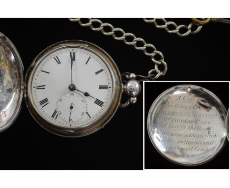
Thomas Cass, silver cased pocket of New Zealand interest London 1833. engraved with presentation inscription A gift of the Governors of Christ's Hospital to Thomas Cass a boy of the Royal Mathematical foundation for his diligence and general good conduct, 1834 Cass was the surveyor responsible for laying out part of Canterbury New Zealand.BIOGRAPHY; THOMAS CASS (1817-95).Thomas Cass was born in Yorkshire in 1817. His father died in 1825 leaving his mother with six children including Thomas for whom she obtained a place Christ's Hospital where he was in the Royal Mathematical School for four years, studying navigation. He then went to sea and served in the East India trade. After three years he gave this up and studied architecture and surveying, and on qualifying was employed as an assistant in the Tithe Commission Office, Somerset House. The newly founded colony of New Zealand attracted him and he obtained the post of assistant surveyor with the New Zealand Company. The Prince Rupert, in which he left England, was wrecked at the Cape of Good Hope, and with it went most of his belongings. He continued his voyage in the Antilla, reaching Auckland in December 1841. He was employed in laying out part of the city of Auckland, at the Bay of Islands, and to the northward where he surveyed the town of Kororareka and prospected road lines to Hokianga and Whangaroa. He then surveyed the north shore of Auckland and after that was again at the Bay of Islands until late in 1844 when the New Zealand Company discharged him owing to the reduction of the survey department. It was then that his service at sea stood him in good stead. He became second, later chief, mate of the Government brig Victoria and was present at the destruction of Kororareka in 1845, and at the operations against Te Rauparaha in Cook Strait in 1846. Other adventures included the transport in custody from Otago to Wellington of Langlands and Davis, two of Canterbury's first bushrangers who had robbed the Greenwoods at Purau in 1845.In 1847 Cass returned to England to press his claim for compensation for the loss of his position as surveyor. The formation of the Canterbury Association led, in July 1848, to the dispatch of an advance party under Captain Joseph Thomas, with Cass and Torlesse as assistant surveyors, to select a site for the proposed Church of England settlement. They sailed in the Bernicia, reached Wellington in November, hired a cutter, the Fly, and with William Fox, the New Zealand Company's agent, and five survey, hands proceeded to Port Cooper, landing at Purau on 15 December. Cass began by making the first detailed survey of Lyttelton Harbour, previously roughly charted by M. Fournier of the French corvette Heroine. When the site for the Canterbury settlement had been decided, he made the first trigonometrical survey of the Christchurch district preparatory to the laying off of the town itself. He next surveyed the Lincoln and Ellesmere districts. In January 1851, on Captain Thomas's precipitate departure, he became Chief Surveyor in Canterbury, a position which he held until March 1867 when he retired on account of his health - he suffered from chronic asthma. He played a prominent part in the life of the young community. In 1853 with Sewell and the Rev. R. B. Paul, he fixed the site of Christ's College. He was one of the members of the first Provincial Council of 1857. He was in the Executive Council under Moorhouse and again under Bealey. For 10 years he was a member of the Canterbury Waste Lands Board, and served on various commissions connected with the development of communications in the province.In 1867 he revisited England and succeeded Crosbie Ward as immigration agent for Canterbury. While he was there, Samuel Butler painted a portrait of him which is now in the Canterbury museum. Cass returned to Christchurch in 1868. He was a member of the Church of England and served as churchwarden at St. Michael's. He married the widow of David Theodore Williams in 1856. They had no family and after his wife's death in 1885, he lived very quietly with his stepson, C. Hood-Williams, until his death in Christchurch on 17 April 1895.Cass filled the post of Chief Surveyor with distinction, and brought to the deliberations of the various bodies of which he was a member a profound knowledge of the province. He was a delightful character, known affectionately to all as Tommy, and noted for his benevolence. His name is perpetuated in a township, a river, a bay, and a Banks Peninsula peak.
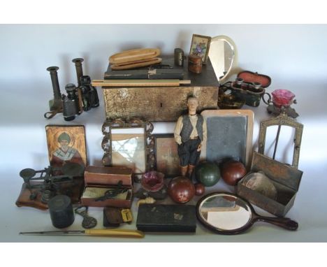
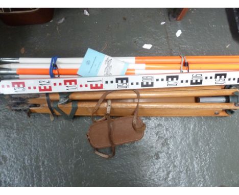
A miscellaneous collection (3 boxes) to include a set of postal scales with graduated associated weights, a boxed medicinal glass beaker, a boxed pocket surveyor, vintage cased and other binoculars, an unusual clothed timber work figure of a male with naturalistically painted facial detail, a late 19th/early 20th century cash box of rectangular form, etc
Hargreaves Map of the Staffordshire Potteries & Newcastle Hargreaves (Thomas, land surveyor and engineer ) Map of the Staffordshire Potteries & Newcastle, Including their Vicinities, Shewing the Limits of the Boroughs, Parishes, Townships, etc., Engraved from a Minute Trigonometrical Survey, hand-coloured engraved map on paper, in sections, on linen, slightly browned, approximately 158 x 122cm., Burslem, 1st May 1832.
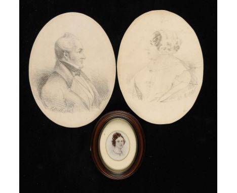
BY AND AFTER CHARLES DAVIDSON BELL, FRSE (1813-1882) PORTRAITS OF THE HON JOHN BARDWELL EBDEN OF EKELENBURG, RODENBOSCH, CAPE COLONY AND HIS WIFE ENID BELL SANDERS, NÉE HOPKINS two, lithographs 1849, oval, 24 x 18cm, a Victorian photograph of a miniature of their daughter Martha Antoinette Ebden at about the time of her marriage to Charles Davidson Bell and a small group of other prints and photographs mainly of members of the Brodie family The lithographs of pencil drawings by Bell would appear to be extremely rare and were presumably printed in the Colony. Charles Davidson Bell was the first Surveyor General in the Cape Colony and an accomplished artist, who designed by the famous triangular Cape of Good Hope postage stamps. He married, as his first wife, on 3rd June 1841 Martha Antoinette Ebden by whom he had three children before divorcing her in 1850 on the grounds of her adultery with Dr Lestock Wilson Stewart. ++Lithograph of Mrs Ebden with tears, small losses and creases. Both slightly browned. The carte des visite in excellent condition, unexamined out of the frame
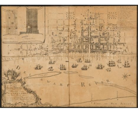
AN EARLY ENGRAVED MAP OF PHILADELPHIA, NICHOLAS SCULL, 1762To the Mayor, Recorder, Aldermen, Common Council and Freemen of Philadelphia this plan of the improved part of the city, surveyed and laid down by the late Nicholas Scull, Esqr., Surveyor General of the Province of Pennsylvania, is humbly inscrib'd by the editors., Philadelphia: Sold by the editors, Matthew Clarkson and Mary Biddle, 1762. Measurements: 48.5 x 66 cm (19 1/8 x 26 cm) [sight]PROVENANCE Collection of Jacob Gamble, Philadelphiathence by descent in the family (according to a handwritten note dated June 8, 1931, affixed to the backing)LITERATUREM.P. Snyder, City of Independence: Views of Philadelphia Before 1800, (1975), pp. 62 ff.S. Bedini, The Scull Dynasty of Pennsylvania Surveyors, in Professional Surveyor Magazine (May 2001)LOT NOTESA very rare map and important historical document in its own right, the last time a similar map was offered at public auction was at Sotheby's auction of Fine Books and Manuscripts on June 11, 2013, with an estimate of $100,000-150,000. As Martin P. Snyder notes about this map in City of Independence, this map was the first detailed map of the interior of Philadelphia. It was the first map to identify all the streets and alleys of Philadelphia, and the exact locations of important institutions of the time. The cataloguing for the Sotheby's lot notes that they located only five copies in public institutions: Philadelphia, Historical Society of Pennsylvania (2 of which one is defective); Philadelphia, Library Company; New York Public Library, Stokes Collection; Washington D.C., Library of Congress. PLEASE NOTEIf you will be bidding live on auction day, please note that Session I of the Auction (Russian Fine & Decorative Art), starts at 10:00 AM New York Time and goes from Lot 1 through Lot 234. Session II of the Auction (European, American and International Fine & Decorative Art) starts at 2:00 PM New York Time and goes from Lot 500 through Lot 657. We sell approximately 70 lots per hour.
including: Bicester Market… About 50 Dozens of Choice Geraniums, Fuschias including: Bicester Market About 50 Dozens of Choice Geraniums, Fuschias, and Bedding Plants, 1866; Blackthorne: 18½ Acres of Capital Grass Crop, manuscript note by "HW King" land surveyor, 1870; Bicester Easter Fair About 20 Tons of Yellow Globe Mangold Wurtzel, 1881; Bicester Market About 30 Tons of Mangolds, 1896, together c. 25 agricultural posters, folds, some creasing and browning, some tears, v.s. (smallest 520 x 390mm. & largest 760 x 500mm.), printed at Bicester for Jonas Paxton, v.d., 1866-96 (c. 25).
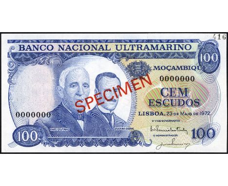
Mozambique, P 113s, Banco Nacional Ultramarino, Moçambique, 100 Escudos, May 23, 1972, SPECIMEN. Portrait of G. Coutinho and S. Cabral at left on front. Surveyor at center on back. Diagonal red overprint SPECIMEN on front and back. Black specimen number 416 in upper right margin on front., # 0000000, UNC
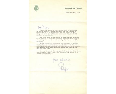
PRINCE PHILIP: (1921- ) Duke of Edinburgh, husband of Queen Elizabeth II. T.L.S., Philip, with holograph salutation and subscription, one page, folio, Buckingham Palace, 26th February 1973, to ‘Dear Dean’. The Duke states ‘Rupert has shown me your letter about Dykes Bower. It is, of course, a matter entirely for the Chapter to decide who is to be responsible for the fabric of the Abbey and there is, of course, no reason why you should not have a consultant’ and continues ‘The only point I was trying to make was that it would be prudent to be sure that everyone concerned knew exactly where they stood in this and exactly who was responsible for what. I most certainly appreciate how necessary it is for the Trustees to work in close consultation with the Dean and Chapter in such matters, but after all you have brought the Trustees into being to offer advice and that is all that has been done.’ before concluding ‘You may remember the saying, which goes something along the following lines, “Don’t buy a dog if you intend to do the barking yourself”.’ VG Stephen Dykes Bower (1903-1994) British Church Architect, known for his work at Westminster Abbey, where he was official Surveyor of the Fabric from 1951-73.
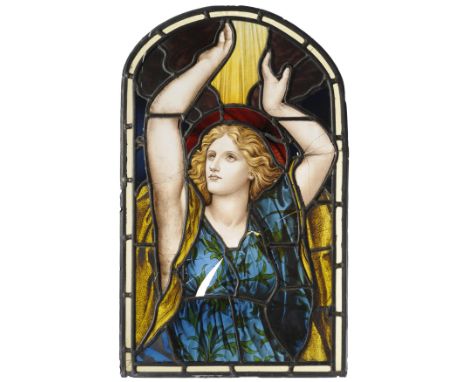
Henry Holiday (1839-1927), Attributed to: A Panel, circa 1878, Stained Leaded Glass, painted with a maiden with arms stretched above her head, 71cm by 43cm (damages) Possibly removed from St.Maurice's Church, Monkgate, York, rebuilt in 1878 to a design by Charles Fisher (local architect), replacing the smaller 12th century church (demolished in 1876). This new church was itself demolished in 1967 and was on the corner of Lord Mayor's Walk and Monkgate. Given to the vendor by a quantity surveyor who salvaged the panel from a church demolition in the 1960's, and who had worked on the York St. John's University development on Lord Mayor's Walk.
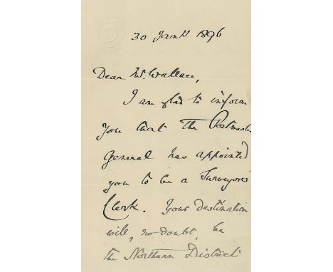
Autograph letter signed with embossed ‘General Post Office Edinburgh’ head Autograph letter signed ( W.R. Mitford ) with embossed General Post Office Edinburgh head, appointing G. Wallace as Surveyor s Clerk and specifying your destination will, no doubt, be the Northern District when the necessary arrangements have been made ; 2 pages, mailing folds, ink slightly faded, 8vo, 30th January 1896. Also included are the envelope signed by Mitford addressed to G. Wallace and containing his letter of appointment as Surveyor s Clerk and his temporary pass and a pen sketch probably featuring Wallace working at his desk.
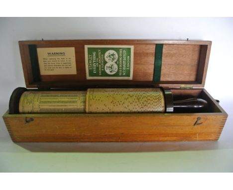
A cased vintage Fuller calculator with Bakelite handle and bracket, stamped Stanley Trade Mark, housed within a bespoke timber case of rectangular form with green felt lined supports, the box lid interior bearing the label Stanley, Everything For The Engineer, Architect And Surveyor In Field And Drawing Office, W F Stanley & Co Ltd, London
A photograph of a 19th century gentleman, thought to be H E Buckley, a surveyor in Yorkshire, original owner of lots 385-394 in this sale, (Great-Grandfather of the Vendor, his son reputedly designed Beer Water Tower and Lulworth Water Pump Station) together with a photograph of Gouthwaite Masonry Dam, 1903, a Surveyor's drawing board and set squares
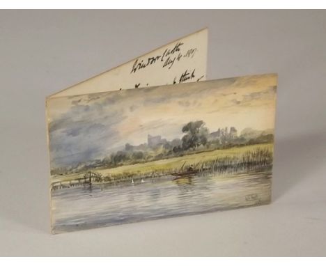
ALFRED YOUNG NUTT. A miniature watercolour, a of a view of Windsor from the river. Signed & dated 1907. 6 x 9cm. Accompanied by a hand written note addressed from Windsor Castle 1907, dedicating the small watercolour to his daughter. Note: AY Nutt was Surveyor to the Dean and Canons of Windsor Castle & Clerk of Works, until his retirement in 1912.

KITCHENER HERBERT: (1850-1916) British Field Marshal. Two Ls.S., H H Kitchener, each one page, folio, Cairo (?), 1888 & 1889, to the Head of the Department of Seizure and Coordination, in Arabic. The official manuscript letters of introduction appear to refer to several Egyptian lieutenants under Kitchener`s command, named as First Lieutenant Ali and Second Lieutenant Shaaban, and states that they have recently served in the Police warehouse. Kitchener writes to enable the lieutenants to approach a high ranking official, in charge of the department for the seizure of land and assets, most likely in the Sudan. Together with a third Arabic letter (not signed by Kitchener) on the stationery of the office of the Surveyor General at the War Office, Cairo. Some age wear to the edges and one letter with an extensive, although neat, split at the fold. G to about VG, 3
Dury (Andrew) - An Actual Survey of the Provinces of Bengal, Bahar &c., the survey by Major James Rennell, Surveyor General to the honourable the East India Company, engraved map with original hand-colouring on 2 sheets, unjoined, approx 995 x 1500mm., if joined, the sheets lined, slight surface dirt and some rolling creases, Laurie and Whittle, 1794.

KITCHENER HERBERT: (1850-1916) British Field Marshal. Two Ls.S., H H Kitchener, each one page, folio, Cairo (?), 1888 & 1889, to the Head of the Department of Seizure and Coordination, in Arabic. The official manuscript letters of introduction appear to refer to several Egyptian lieutenants under Kitchener's command, named as First Lieutenant Ali and Second Lieutenant Shaaban, and states that they have recently served in the Police warehouse. Kitchener writes to enable the lieutenants to approach a high ranking official, in charge of the department for the seizure of land and assets, most likely in the Sudan. Together with a third Arabic letter (not signed by Kitchener) on the stationery of the office of the Surveyor General at the War Office, Cairo. Some age wear to the edges and one letter with an extensive, although neat, split at the fold. G to about VG, 3
-
1532 item(s)/page