We found 1532 price guide item(s) matching your search
There are 1532 lots that match your search criteria. Subscribe now to get instant access to the full price guide service.
Click here to subscribe- List
- Grid
-
1532 item(s)/page


Lot 25
Nick Nicholls (1914-1991) A View of Dublin from the Phoenix Park Gouache and ink on paper, 32 x 39cm (12½ x 15") Signed and dated '40 Victor Waddington framing label verso Provenance: Acquired directly from the artist by the current owner's family in the 1940s This work is thought to be after the well known painting by William Ashford (1746-1824) of the same title painted between 1795-98 (which can be found in the National Gallery of Ireland's collection). Born in Salisbury, Wiltshire, the son of an English father and an Irish mother. As a child he spent a good deal of time with relatives in County Cavan. A quantity surveyor by training, in 1935 he turned to painting, in which he was self-taught. His early pictures are conventional watercolours, but later he embraced surrealism and other forms of abstraction, being influenced by Cézanne, Picasso, Klee and Miró. While living in London he took a studio in Fitzroy Street and exhibited at the influential Spectrum Gallery. With the approach of war he moved to Dublin along with Georgette Rondel and remained there until 1946. He was introduced to the White Stag Group by Basil Rákóczi, whom he met in Dublin. In 1946 he experienced a deep religious conversion and henceforth religion played an important part in his thinking. In 1953 he gave up painting and began to study philosophy and religion, but he returned to painting in the 1960s, being by then influenced by native African art and the work of the French painter Jean Dubuffet (1901-85), with its emphasis on images derived from graffiti and children's art. During his years in Dublin he also wrote and published poetry. Nick Nicholls died in London in 1991.


Lot 147
*Leeds. Baines (John & Company, pubs.), Map of the Country extending Ten Miles round Leeds Including Wakefield, Bradford, Dewsbury, Otley, Harewood, Aberford & Castleford; Shewing all the Parish and Township Boundaries &c. from actual Admeasurements in the years 1819, 20 & 21 by Joshua Thorp and re-surveyed & corrected to January 1st. 1831 by S.D.Martin, Surveyor, Leeds, engraved map with bright contemp. hand colouring, sectionalised and laid on linen, calligraphic title, compass rose, table of explanation and vignette of Kirkstall Abbey, 1140 x 1220mm, framed and glazed. Brian Kentish, A Catalogue of County Atlases of England and Wales 1607-1868 and Large Scale county Maps, item 79. (1).
Lot 273
[Care, Henry]. English Liberties: Or, the Free-Born Subject’s Inheritance, Containing I. Magna Charta... II. The Proceedings in Appeals of Murther... III. The Terms of Liberty of Conscience... IV. An Abstract of the Penal Laws against Popish Recusants, Priests and Jesuits, V. The Office and Duty of a Constable, Churchwarden, Surveyor of the Highways..., 1691, A3 bound after A4, a few leaves trimmed shaving headlines, occasional spotting and soiling, lacking endpapers, previous owner signature to title, contemporary calf, joints cracking, a little bowed, 12mo. Wing C518.. (1).

Lot 344
Three Indian Buddhist white clay votive or cremation tablets, probably 8th or 9th Century AD, each having press moulded decoration, 3.5cm high, 5cm high and 14cm high, also included is a hand written note dating from approximately 1900 and signed by August Hermann Francke which reads `Cremation Clay Tablets (Potted Lamas from Khalatse. These tablets were excavated at an ancient site near Khalatse and stored up at the Mission House. Specimens were sent to Dr. Ph. Vogel, Archaeological Surveyor, Lahore, who read the inscription and pronounced it to date from the eighth or ninth century A.D. according to the form of its characters. It contains the well known ancient Buddhist formula in Sanskrit. Translation by Rhys Davids; of all objects which proceed from a cause, the Tathagatha has explained the cause, and he has explained their cessation also, this is the doctrine of the great …., the small tablet contains a figure of the White Tara. The middle sized table contains a figure of Manjughosa. A.H. Francke Moravian Missionary` General condition consistent with age **


Lot 690
Reynolds M. : The Town of Bedford C.1844. Linen backed, engraved map of the town by the borough surveyor. Glazed surface with ornate engraved title and dedication; mounted on rollers for wall-hanging display. CONDITION REPORT: Condition : Edges slightly frayed but not affecting the map margins; overall surface a little browned but details clear and crisp.


Lot 230
Emigrant Letters 1882-1896, Wyoming. Letters between Walter Cowan and Joseph Jefferson who had been students together in 1881 at Moss Farm Academy, West Derby, Lancashire. They emigrated together to Wyoming and set up the Sand Creek Land and Cattle Co. Saratoga. In 1889 Jefferson married and returned to England settling in Lorton Hall, Cumberland. Cowan remained with his brother James who became a US Deputy Minerals Surveyor. James was consulting engineer and manager of the Golden Eagle Syndicate set up in 1896 to develop a gold mine in the Saratoga area. This collection of original letters is between Walter Cowan and Joseph Jefferson and relates to the Sand Creek Land and Cattle Co. and the Golden Eagle Syndicate. The London School of Economics Archive of Emigrants' Letters has a large collection of correspondence from the Cowan brothers to family and friends at home and included are a number of copy letters from this collection. Also included are printed documents relating to the Sand Creek Land and Cattle Co. and the Golden Eagle Syndicate together with a research file.
Lot 177
England & Wales. Kitchin (Thomas), A New Map of England and Wales Drawn from Several Surveys &c. on a New Projection, Corrected from Astronomical Observations & the Places marked where the Observat’ns were made....., the Canals inserted to 1792 by J.Phillips Surveyor, pub. Laurie & Whittle, 12th May 1794, large engraved map with contemp. outline colouring on two sheets conjoined, inset map of The Scilly Isles, large decorative b & w cartouche, list of canals and table of explanation, old folds, occ. repaired tears, slight dust soiling, 1285 x 1085mm, together with Andrews (John),A New Physical, Historical & Political map of England and Wales from actual Surveys & Astronomical Observations of the Royal Society....., 1st. ed., 1786, engraved map on six sheets conjoined in pairs, contemp. hand colouring, calligraphic cartouche and table of explanation, inset map of the Scilly Isles, slight marginal spotting and staining, occ. repaired marginal closed tears, overall size 1590 x 1300mm, plus Arrowsmith (J.),England, 1832, engraved map with contemp. outline colouring, 630 x 505mm (3)
Lot 194
Ireland. Bellin (Jacques Nicolas), Carte Generale des Costes D’Irlande et des Costes Occidentales D’Angleterre avec une Partie de celles D’Ecosse, pub. Paris, n.d., c.1760, uncoloured engraved sea chart, inset map of Chester and the River Dee, compass roses and numerous rhumb lines, ‘Depot de la Marine’ stamp, slight staining, trimmed to plate mark along lower margin, 620 x 870mm, together with Carte Reduite des Isles Britanniques Cinquieme Feuille Contenant L’Irlande, c.1760,uncoloured engraved sea chart, decorative cartouche, ‘Depot de la Marine’ stamp, slight water staining just affecting image, 890 x 580mm, with Admiralty Chart (pubs.), Bedford (Commander G.A., Surveyor), Ireland, W.Coast, Galway Bay, c.1898,uncoloured litho. sea chart, short split to central fold, 630 x 960mm (3)

Lot 60
Cary (John, publisher). Cary’s Actual Survey of the Great Post Roads between London and Falmouth including a Branch to Weymouth as well as those from Salisbury to Axminster thro’ Dorchester or Sherborne; Those from Basingstoke to Salisbury either thro’ Popham Lane or Andover; and those from Exeter to Truro, either thro’ Plymouth or Launceston...., ascertained by A.Arrowsmith Land Surveyor, 1782, pub. J.Cary. 1784, general strip map frontis., dec. eng. title page, fifty (complete) uncoloured engraved strip road maps, very occ. staining and offsetting, contemp. marbled covered boards with recent calf spine, 12mo. Rare. The only copy to the come on to the market in the last ten years was the Wardington copy in 2007. (1)


Lot 215
Scottish Naval Log - H.M.S. Romney, 29 Nov. 1800 - 1st June 1803 - Capt. David Ewen Bartholomew of Linlithgowshire, 1767- 1821H.M.S. Romney`s log from England up the Red Sea & to Bengal in 1800 and 1801, D.E. Bartholomew, [and] from Sangar to the Prince of Wales Island, Dec. 1801, [and] from Prince of Wales Island to Madras in 1801 and 1802"; [and] from Cochin to Mocha in Jan. & Feb. 1802; [and] from Mocha to Inddah in July 1802" [and] from Inddah to Suez in Feb. & March 1802, [and] from Suez to Bombay 1802, [and] from Bombay to England via St. Helena, 27 Oct. - 11 April 1803; with a section on "Time-keepers", in all c. 500 pages, nineteenth century maroon half morocco, a few leaves dampstained, lightly rubbedProvenance: Admiral Sir John Ross. Inscribed on front endpaper "Hartwell Library, presented by Admiral Sir John Ross" and with a list, signed by Admiral Ross, "of articles in a ? for Doctor Lee", listing various naval logs including this journal. Hartwell House in Buckinghamshire, belonged in 1810 to the Lees, an old Buckinghamshire family. Armorial bookplate of John Lee of Hartwell (1783-1866), with motto `Verum atque decens`. [Property of the Trustees of Lord Gretton]Note: A naval log by an exceptional Scottish surveryor and cartographer. Captain David Ewen Bartholomew, CB (c. 1767 - 1821) was an officer of the British Royal Navy and Merchant Navy, who rose from a poor background to become a post captain and prominent surveyor and cartographer, and was the first British man to map numerous sections of the South American, Arabian and African coastlines. He was born into a poor family in Linlithgowshire, was press-ganged twice, once at the instigation of the First Lord of the Admiralty, Lord St. Vincent, served in various naval engagments, and in 1802 was in charge of H.M.S. Romney`s chronometers during a voyage to the Red Sea. Bartholomew`s abilities as a surveyor and cartographer were highly regarded and, later in his career, he conducted important surveys of the Argentine, Persian and West African coasts. Bartholomew was also considered exceptional for his rise from an impressed sailor to post captain at a time when this was almost impossible to achieve.


Lot 409
BEAN ALAN: (1932- ) American Astronaut, Lunar Module Pilot of Apollo XII (1969), the fourth man to walk on the moon. Signed colour 39.5 x 8 photograph, the panoramic image (captured by Bean, his shadow evident in the foreground) showing astronaut Charles Conrad working at the equipment bay of the lunar module at the Ocean of Storms. Signed by Bean in bold silver ink to the image, adding Apollo 12 LMP in his hand beneath his signature. Bean has also identified various points and apparatus etc. on the moon, annotating the image in his hand with the names of Surveyor Crater, an antenna, television camera etc. Double matted in dark green and white and framed and glazed in a plain coloured frame to an overall size of 45.5 x 18. EX

Lot 443
LIGONIER JOHN: (1680-1770) British Field Marshal. D.S., J L Ligonier, one page, small folio, Office of Ordnance, 14th October 1757. The attractive manuscript document is an order for various items, including paper cartridges, ladles & spunges, tackle hooks and aprons of lead, to be issued from His Majesty's stores and sent to Woolwich where they have been requested by the officers for supply of Naval stores. Signed by Ligonier at the foot and countersigned by Charles Frederick (1709-1785, Surveyor-General of the Ordnance 1750-82). Originally from the noted collection of Ray Rawlins and bearing his small circular stamp to the verso. One small area of paper loss in the lower left corner, not affecting the text or signatures. Together with George Wade (1673-1748) British Military Commander, Commander-in-Chief of the Forces, 1745. D.S., George Wade, one page, small folio, Office of Ordnance, 16th September 1742. The attractive manuscript document is an order for various items, including oyle and beeswax, to be supplied to the Gunners Stores on board His Majesty's Ship Royal Caroline commanded by Captain Charles Molloy. Signed at the foot by Wade and countersigned by Thomas Lascelles (1670-1751, Colonel) and one other. With blank integral leaf. Originally from the noted collection of Ray Rawlins and bearing his small circular stamp in the upper right corner. Some slight splitting at the folds, also including George Beauclerk (1704-1768) British General, Governor of Gibraltar. Son of the 1st Duke of St. Albans and grandson of King Charles II and his mistress Nell Gwynne. A.L.S., G Beauclerk, two pages, 4to, Edinburgh, 5th January 1764, to a gentleman. Beauclerk writes to his correspondent on military matters, referring to various individuals and officers and giving his reasons for not agreeing to allow Lieutenant Gordon to retire on full pay. With blank integral leaf. Some light foxing, otherwise VG, 3


Lot 43
Wellsted (James Raymond). Travels to the City of the Caliphs, along the shores of the Persian Gulf and the Mediterranean. Including a Voyage to the coast of Arabia, and a tour on the island of Socotra, 2 vols., 1st ed., 1840, folding b&w map (torn without loss), two tinted litho. views, inner margin between frontis. and title page of each vol. cracked with minor chipping, 19th century half calf, rubbed and scuffed, with a little wear to extrems., 8vo. Howgego III, 635. The surveyor and traveller James Raymond Wellsted (1805-1842) was appointed by the East India Company in 1830 as 2nd Lieutenant of the Ship Palinurus to survey the Gulf of Akaba and the northern part of the Red Sea, and in 1833, the southern coast of Arabia. (1)


Lot 653
HODGSON`S MAPS OF WESTMORLAND, 19th century, two printed and hand coloured folding maps held within a leather covered double section case formed as a book, published by Thomas Hodgson surveyor October 6th 1828, Lancaster, and sold by C Smith 172 Strand London. Condition Report: Wear throughout case with some losses etc, the maps generally ok but with some staining etc, viewing advised.


Lot 211
A SURVEYOR’S LEVEL BY BAKER, LONDON, in oxidised-brass with lacquered fittings, signed on the main tube Baker, 244 High Holborn, London 2818, bubble levels, compass, levelling screws and base plate for tripod attachment, contained in fitted mahogany box with leather strap -- 16in. (40.5cm.) wide; together with a ‘Walker’s’ yacht log and impellor, (2)

Lot 212
AN 18TH-CENTURY MAHOGANY AND BRASS SURVEYOR’S LEVEL BY COTTAM & HALLEN, LONDON, comprising a lacquered-brass quadrant, signed and inscribed Cottam & Hallen Winsley Strt, London No 180, the scale divided 12-0-12 and inscribed to left Inches Full In 3 Feet, and to the right Inches Rise In 3 Feet, thumb-screw retention, the crossbar with folding pin-hole and cross-hair sights, shaft terminating in a sharp point with foot plate; accompanied with matching surveyor’s staff -- dimensions overall 56½ x 54in. (143.5 x 137cm.), (2)

Lot 278
A BUILDER’S MIRROR-BACKED HALF-MODEL FOR THE STEEL SCHOONER-RIGGED STEAM YACHT VENETIA, BUILT BY HAWTHORNE & CO. TO DESIGNS BY COX & KING, 1903, the laminated and carved hull with glazed portholes, silvered fittings including anchor with studded cable and winch, deck lights, companionways, masts, binnacle, superstructure with over bridge with binnacle, helm, telegraph, ventilators, cutaway funnel, aft helm and binnacle, capstan and other details, mounted on a front-silvered mirror within glazed wooden case with details plate, overall measurements -- 27½ x 74½in. (70 x 189.5cm.), Owned by several well-known yachtsmen over the years, Venetia served out of Gibraltar during World War I where, with the assistance of the U.S. Coast & Geodetic Survey vessel Surveyor, she was credited with damaging U-39 so severely, the submarine was forced to seek internship with Spain. Her later years were spent in Canada on the Great Lakes, and she disappeared from Lloyds’ List in 1968.


Lot 519
PADSTOW, CORNWALL. AN INTERESTING GROUP OF FOUR VICTORIAN SILVERED BRONZE SEALS including a combination seal with interchangeable matrices, the ten engraved matrices comprising Cornwall arms and crest/arms of Sloggett, three engraved THOMAS HENRY SLOGGETT PADSTOW or SLOGGETT CORNWALL, 8cm h and smaller Provenance: Captain Thomas Henry Sloggett (1824-1912) Board of Trade Marine Surveyor. The silvering mostly worn and with polish residue but well made and in good overall condition


Lot 19
Phillimore (Col. R.H.). Historical Records of the Survey of India, vol. II (1800 to 1815) only, pub. Survey of India, 1950, twenty-four colour and b&w maps and plans etc., many folding, with single withdrawn stamp from the National Army Museum collection, dated 2011, to front endpaper, orig. green cloth gilt, some minor marks and lightly damp flecked to edges, small folio. With a partly hand written presentation slip from Brigadier G. F. Heaney, Surveyor General of India, to Brigadier H. Bullock, presenting this work, dated 17th August 1950, and two leaves of typescript copy of a note to the author Colonel Phillimore, dated New Delhi, 6th September 1950, but unsigned, providing some minor corrections to the publication (possibly from Brigadier Bullock), loosely inserted. (1)


Lot 461A
PEPYS SAMUEL: (1633-1703) English Naval Administrator and Diarist. L.S., S Pepys, one page, folio, Navy Office, 9th February 1668, to Mr. Shippwet, Ch. Cherq. & Storekeep at Chatham. The manuscript letter seeks clarification of the claims made by a labourer working for the King and states, in full, `Wee have seene your certification at yr. bottome of a peticon of Danl. Bowtroolls the Kings MarCaulker at Chatham, and having good reason to doubt that his pretence to yr. Joyners house is grounded upon a designe of yr. late Joyners to prejudice him that who succeede him. Wee desire you to informe us what you can learne touching yr. grounds of yr. said Joyner no earlyer declaring yr. Caulkers right to his house.` Countersigned by three Commissioners of the Navy, William Brouncker, 2nd Viscount Brouncker (1620-1684) English Mathematician, first President of the Royal Society, Sir John Mennes (1599-1671) English Vice Admiral, Controller of the Navy and Colonel Thomas Middleton (d.1672) Surveyor of the Navy 1667-72. Some very light, minor overall foxing and some slight chipping to the left edge. About VG The letter dates from the period of Pepys` Diaries and as such is scarce and desirable. Indeed, Pepys makes references to the three countersignatories in his diaries, expressing his disgust at Brouncker for living out of wedlock with the actress Abigail Williams and describing Mennes as being `ill at ease` in his role as a Commissioner of the Navy.


Lot 222
Colorado Springs, Colorado (Birds Eye View of Colorado Springs and Vicinity), Anon., ca. 1900. 17 x 24”. (BW) This rare, anonymous promotional map of Colorado Springs shows a developing city with an impressive view of the Front Range in the background. Colorado Springs was founded in 1871 by William Palmer, a former Civil War General. Palmer was a surveyor for the Kansas Pacific railroad and secured legislation and funding for the Denver & Rio Grande railroad. Palmer thought this area was ideal for a town, and announced Colorado Springs as the route`s first destination out of Denver. As a result of the new infrastructure and the Pike`s Peak gold rush, the city became one of the most popular tourist destinations in the west. Printed on thin, banknote style paper. There are a few short splits at fold intersections and a number of small fold separations, some of which have been repaired on verso with archival tape. (B)

Lot 232
Southern Florida, Bahamas, Cuba (A Chart of the Gulf of Florida or New Bahama Channel, Commonly Called the Gulf Passage…), Faden, London, 1794. 29 x 23”. (HC) This chart was completed by Charles Roberts, Master of the Royal Navy, and is based on the work of George Gauld, a Scottish surveyor. Gauld was assigned by British Admiralty to chart the waters off the Gulf Coast from Louisiana to the Bahamas. He arrived in the Florida area in 1764 on the English ship Tartar, along with John Harrison’s son. William Harrison was on board to test his father`s clock Number Four, which was designed to determine longitude at sea. Although Harrison returned to England soon after arriving in Barbados, his longitude measurements were determined to be accurate to two minutes, or two miles. This data aided Gauld in creating extremely accurate charts. Realizing the importance of his work, Gauld began sharing manuscript charts of his early work with scientific societies in America. The Revolutionary War forced Gauld to suspend his work due to attacks by American privateers, and he was taken prisoner in 1781 and repatriated to England, where he died. This rare sea chart depicts southern Florida, the Keys, the Bahamas, and the northern coast of Cuba. Extensive detail of soundings, shoals, navigational hazards, safe anchorages, and wind and water currents is shown. Seven coastal views are depicted in Cuba, and a small inset shows enlarged detail of the islands from Nassau to Booby Rocks. A table with the longitudes and latitudes of various locations fills the top right corner. This map was published by William Faden, who published many of Gauld`s charts. Original outline color with toning, minor offsetting, and light scattered foxing at top. There is a clean centerfold separation that enters 2.5" into map at top, a tear that enters 1/2" into map at top of the cartouche, and several small chips and tears in blank margins, not affecting map. (B)
![New York ([Lot of 7 - New York Canal Maps]), 1868-69. x ”. (BW) This lot of seven maps shows the evolving canal network](http://lot-images.atgmedia.com/SR/36385/2862480/278-2012510162546_468x382.jpg)
Lot 278
New York ([Lot of 7 - New York Canal Maps]), 1868-69. x ”. (BW) This lot of seven maps shows the evolving canal network in the state, along with some detail of railroads, lakes and rivers. The maps were compiled by Van Rensselaer Richmond, the State Surveyor of New York and include: A. Maps Showing the Lakes and Streams in the State of New York. Also the Rail Road & Canal Lines , dated 1868, (28 x 22.8"). Condition: Light offsetting with a few tiny splits at fold intersections and a binding trim at left.. (B+) B. Map of the New York State Canals Completed and in Progress, dated 1868, (40 x 24.3"). Condition: Light offsetting with a few small splits at fold intersections. (B) C. Map Showing the Connections of Champlain Canal St. Lawrence, Ottawa, Rideau and Richelieu Canals of Canada, dated 1868, (19.3 x 7.8"). Condition: Light offsetting. (A) D. Welland Canal, dated 1868, (9.3 x5.8"). Condition: (A) E. Map of Chenango Canal Extension, dated 1868, (33.8 x 8"). Condition: Light offsetting, else very good. (B+) F.Northern Region Between the Atlantic and Pacific Showing the Chains of Lakes, dated 1868, (34 x9"). Shows the canal network from New York to the Pacific Ocean. Condition: Binding trim at lower left and a hint of offsetting. (A) G. Map of Proposed Fish Creek Feeder, dated 1869, (25.8 x 16.3"). Condition: Binding trim at lower left and a hint of offsetting. (B+) See descriptions. ()

Lot 909
Exploration and Surveys (Report of the Exploring Expedition to The Rocky Mountains in the Year 1842, and to Oregon and North California in the Years 1843-44), Fremont, HR Doc. 166, Washington D.C., 1845. 6 x 9”. (BW) Fremont and his colleagues covered some 10,000 miles between the frontiers of the Missouri and the shores of the Pacific. The report made substantial contributions in the fields of surveying, topography, and natural history. Fremont`s report was the most widely read account of the West before the gold rush, and its contents and maps had a profound effect on the development of emigration routes. The expedition party included such notable explorers as the German topographical surveyor Charles Preuss, the American guides L. Maxwell and Christopher Kit Carson and the celebrated botanist John Torrey. The lithograph plates in this report include illustrations of both the countryside and flora, as well as plates of fossils, ferns and shells. This is the House of Representatives issue, which preceded the Senate version. Octavo, hardbound, quarter calf with gray cloth covers, 583 pp., 23 plates and 4 maps (of 5 - lacks the large folding map). The body of the book contains Fremont`s two reports, titled "A Report on an Exploration of the Country Lying Between the Missouri River and the Rocky Mountains" and "A Report of the Exploring Expedition to Oregon and North California, in the Years 1843-`44." Ref: cf. Wagner-Camp 115:2. There is scattered foxing throughout the pages and plates, with a few pages marked with a highlighter (yellow), but the contents are tight. Both maps have scattered foxing and one has archival tape on verso to reinforce the folds. Covers and spine show some light wear and the edges are bumped. (B)


Lot 526
Sir John Charles Robinson, British 1824-1913- Loch Portree, Isle of Sky; watercolour, bears label to the reverse, 47.5x92cm. Note: The artist Sir John Charles Robinson studied in the studio of Michel-Martin Drolling in Paris. Appointed curator of the Museum of Ornamental Art at Marlborough House. In 1857 this collection was moved to the newly establish South Kensington Museum where he worked until 1867. He was appointed Surveyor of the Queen`s Pictures i 1882 and acted in this capacity until 1901.

Lot 57
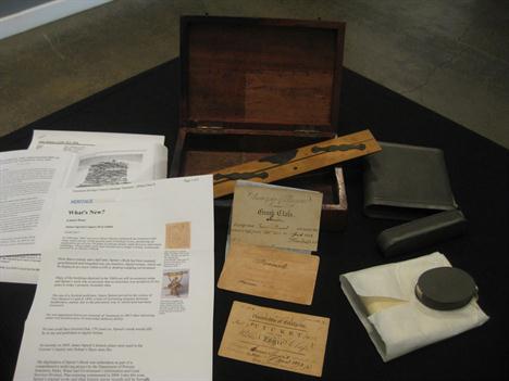
A collection of documents and items relating to James Sprent, surveyor of Hobart town in 1841.Comprising a sealed parchment manuscript (Sprent`s degree certificate), a University of Glasgow class ticket dated 1822, another dated 1823, and another dated 1822/23, a Reeves ruler and a zinc document case. (…) No one could have foretold that 170 years on Sprent`s work would still be in use and published in digital format. As recently as 2009, James Sprent`s historic plans were used in thecoroner`s enquiry into Hobart`s Myer store fire. Illustrated online at: www.mossgreen.com.au

Lot 226
* Ogilby (John). The Road from London to Holy-head co. Anglesey North Wales actually Survey’d and Delineated, c.1676, hand coloured engraved strip road map, elaborate cartouche showing a surveyor using a waywiser, slight overall browning, 310 x 435 mm, mounted framed and glazed. The road commences in London and travels through Highgate, St. Albans, Dunstable, Stoney Stratford and Towcester. (1)
-
1532 item(s)/page