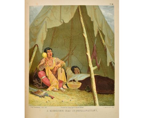
Schoolcraft (Henry R). Historical and Statistical Information respecting the History, Condition and Prospects of the Indian Tribes of the United States, 6 volumes, 1st edition, Philadelphia: Lippincott, Grambo & Company [volumes 5-6: J. B. Lippincott & Company], 1851-7, half-titles, additional engraved title pages to volumes 1-5, engraved portrait frontispiece to volume 6, 326 (of 330) lithographic, chromolithographic or engraved plates and maps, mainly after Seth Eastman, one folding table, including 58 chromolithographic plates by Ackerman, Bowen or Duval in volume 1, many of the lithographic or engraved plates and maps hand-coloured, occasional tissue-guards, lacking volume 1 plate numbers 40, 42, 52 and 70 (but plates 42 and 70 are reprinted in volume 6 as numbers 27 and 15), variable spotting, browning and offsetting, volume 1 plates 24, 44 and 45 dog-eared, secretarial presentation inscriptions to Buckingham Smith from Luke Lea as Commissioner of Indian Affairs (volume 1 front pastedown), Henry Schoolcraft (volumes 2 and 4 front pastedowns), Seth Eastman (volume 3 front pastedown), and Charles E. Mix (volume 5 front free endpaper), gift inscription from Smith to 'John Cunningham of Sevilla' dated 1864 to volume 1 half-title, ink-stamps of Michelina Gorgolini, Rome, to engraved title page and p. 22 of each volume, modern book-labels of Jay Snider, contemporary ownership inscription to volume 6 title page, volumes 1-5 edges untrimmed in original pictorial cloth gilt, recased, rubbed, wear and restoration to extremities, volume 1 endpapers renewed, volume 6 in modern cloth, large 4to (32.5 x 24.5 cm) (Qty: 6)Howes S-183; Sabin 77849; cf. Field, Indian Bibliography 1379 (with a later issue of the first volume, dated 1853). Presentation set of Schoolcraft's monumental and profusely illustrated survey of the Native American tribes, volumes one to five variously inscribed on behalf of the author, the illustrator Seth Eastman, and two Commissioners of Indian Affairs to Buckingham Smith (1810-1870), diplomat, historian of Spanish exploration in Florida and the Americas, and the first surveyor of the Everglades following Florida's accession to the United States in 1845. Volume one is a first issue, retaining the chromolithographic plates with the imprints of Ackerman, Bowen or Duval, and the unabbreviated title page. An excellent association. In volume three Schoolcraft acknowledges his use of Smith's transcripts of documents held in the Archivo-General, Mexico City, which Smith made during his posting as secretary of legation (1850-2), and of Smith's translation of the 16th-century narrative of Alvar Núñez Cabeza de Vaca. In fact, Smith privately supported the criticism directed against Schoolcraft by archaeologist E. G. Squier (1821-1888) from 1854, but Schoolcraft nevertheless helped secure Smith's next posting as secretary of legation in Madrid (1855-8; see Dippie, Catlin and His Contemporaries , p. 254). Inconsistencies in the numbering of the plates have led to records' also calling for 327 or 332 plates, this last figure counting 'plates' 17, 32, 33 and 36 in volume five as individuals, although they appear on two sheets. Provenance: Buckingham Smith (1810-1870; presentation inscriptions); given by Smith to 'John Cunningham of Sevilla' in 1864 (gift inscription to volume one); library of Michelina Gorgolini, Rome (ink-stamps); Jay T. Snider (bookplates; his sale, 'The Jay T. Snider Collection of Historical Americana', Christie's New York, 21 June 2005, lot 264).

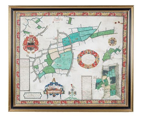
![John Bodger (18th Century) A [ map ] Chart of the Beautiful Fishery of Whittlesea Mere in the County of Huntingdon and](https://cdn.globalauctionplatform.com/af661980-23d2-488e-936e-aa4600c689e5/ca24e2e2-3836-467e-9bce-aa4800c45eda/468x382.jpg)


![[MAPS & ATLASES]. CHINA A folding 'Map of the China Coast and Rough Sketch of the Provinces lying between Canton and Pek](https://cdn.globalauctionplatform.com/96fa8808-0964-41ec-9ebb-aa3600d9f6b5/11bbe114-9876-436c-a666-aa3b011243d2/468x382.jpg)
![Rooke, J[ohn]. Sacred Music. Or a Collection of Psalms, Hymns, and Chants for the Organ, 111 New Lowther Street, Whitehaven,](https://cdn.globalauctionplatform.com/49328683-6a05-4b15-be23-a9a800a8a0bc/352caa4d-b95f-4c5c-a794-a9a801330b44/468x382.jpg)


![Norden, John (1548-1625?) The Surveyors Dialogue. London: Printed [by Simon Stafford] for Hugh Astley, dwelling at S. Magnus](https://cdn.globalauctionplatform.com/e154d3cb-0cea-4b63-a8dc-a9130111b048/178170f5-56f5-4e83-cffb-56b6327e66e4/468x382.jpg)