We found 1532 price guide item(s) matching your search
There are 1532 lots that match your search criteria. Subscribe now to get instant access to the full price guide service.
Click here to subscribe- List
- Grid
-
1532 item(s)/page

Lot 51
Philip (George & Son, publishers). Philip's Handy General Atlas of America, 1879, title and index, 22 (of 23, lacking the map of Kansas) double-page colour lithographic maps, one map detached, upper joint weak and cracked, publisher's gilt cloth, worn and faded, small folio, together with Beers (J. B.). County Atlas of Middlesex Massachusetts..., New York, 1875, calligraphic title, 151 colour lithographic single page, double page and folding maps of town plans, regions and counties, some fraying, marginal chipping and staining throughout, text block detached, publisher's cloth gilt, spine partially lacking, crudely repaired with masking tape, bumped worn and rubbed, folio, with Walker (George H. & Co. publishers). Atlas of Massachusetts..., Boston, circa 1890, calligraphic title, numerous colour lithographic double-page maps, slight staining throughout, publisher's blind-stamped half morocco, boards detached, lacking spine, crude tape repairs to the spine, heavily worn and rubbed, folio, plus, Office of the Surveyor General, (publishers). Alberta and British Columbia Boundary Atlas, Part III from 1918 to 1924, Ottawa, 1925, title printed on the upper siding, index map and 29 colour photolithographic maps, a few maps with red crayon annotations, publisher's cloth gilt, slim folio, and [Garran, Hon. Andrew. Picturesque Atlas of Australasia, 2 volumes (only of 3) 1888], lacking titles and preliminaries, numerous illustrations and maps throughout, some leaves disbound, boards detached, heavily worn and rubbed, folioQTY: (6)NOTE:Sold as a collection of maps and prints, not subject to return.
Lot 536
Wyld (Samuel) The Practical Surveyor, or, The Art of Land-Measuring Made Easy, 2nd edition, London (no date), e. 1730, 8vo., contemporary full calf, neatly re-backed, plates correct although worn and repaired, with 5 others relating to surveying and measurement CONDITION REPORT: Condition information is not usually provided in the description of the lot but is available upon request; the absence of a condition report does not imply that a lot is without imperfection
Lot 98
A Voyage to Hudsons-Bay, By The Dobbs Galley and California, in the Years 1746 and 1747, for Discovering a North West Passage; With an accurate Survey of the Coast, and a short Natural History of the Country. Together With A fair View of the Facts and Arguments from which the future of such a Passage is rendered possible. By Henry Ellis, Gent. Agent for the Proprietors in the said Expedition. To which is prefixed, An Historical Account of the Attempts hitherto made for the finding a Passage that Way to the East-Indies. Illustrated with proper Cuts, and a new and correct Chart of Hudson’s-Bay, with the Countries adjacent. London: Printed for H. Whitridge, at the Royal Exchange. MDCC.XLVIII. [1748] with a dedication to His Royal Highness Frederick, Prince of Wales, a Preface (vii - xxii), a List of Subscribers, including Lord Chesterfield and Charles Stanhope, a Table of Contents, and 336 pages of text, with a large fold-out of “A New Chart of the parts where a North West Passage was sought” at the front, four more fold-outs and four engravings, for a total of nine plates altogether. The book is a first edition, with five raised bands, a gilt title and gilt devices on the spine, with contemporary calf, a gilt crest on both covers, marbled endpapers with the bookplate of Ditton Park, and all the edges are marbled. (Ditton Park is in the English county of Buckinghamshire and belonged to the crown in the reign of Queen Elizabeth I, way back in the 1500’s.) One fold-out shows Wager Strait as a closed bay and includes the first map reference to Chesterfield Inlet (see Schwartz and Ehrenberg: Mapping of America), and apparently the crew suffered from scurvy, which Ellis attributed to two kegs of brandy obtained for a Christmas celebration. Ellis was later elected to the Royal Society for his scientific research on rust and magnetism; his research turned out to be “more or less ingenious, but wildly erroneous”. (Sabin 22312) Ellis was sent on this voyage to find the Northwest Passage and served as hydrographer, surveyor, and mineralogist on the expedition. Dobbs had been part of earlier attempts to find a Northwest Passage, one under the command of Christopher Middleton, an old Hudson's Bay Company employee, and those attempts failed to find anything. Middleton believed no passage existed, yet Dobbs refused to believe Middleton's report. A second voyage of discovery ensued in 1746, this time backed by Dobbs and his friends and commanded by two bitter enemies of Middleton and the Hudson's Bay Company. Two ships were sent on the expedition: the Dobbs Galley and the California - the title of the book here - and their search of the bays and inlets again found nothing, and according to some, this expedition proved decisively that no such passage from Hudson's Bay existed. Ellis and Dobbs continued to believe firmly in a Northwest Passage, and the controversy between Middleton and Doobs simmered for a few years, but had no definite outcome. The book contains some of the earliest information on customs of the Inuit, and you can see that in the plates and engravings here, but a Northwest Passage was never found. The book is 8vo. and measures 8 3/8 x 5 1/2 in. wide, with modest wear on the spine and corners, the first fold-out at the front has some browning, and the rest of the text and plates are clean, and all the plates and engravings are here. An interesting read about the history of Hudson’s Bay and early Canadian exploration.
Lot 536
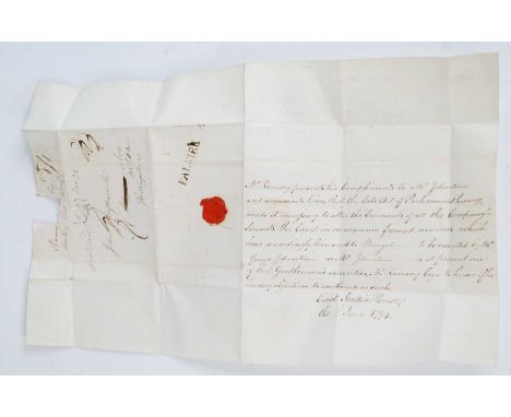
A collection of late 18th and 19th century postmarked / stamped letters, many with broken red wax seals, mainly to and/or from the Scottish gentry and businessmen, to include the Forbes family of Callendar, the Carrron Company Ironworks, Nicol Baird surveyor of the Forth & Clyde Canal, the East India Company secretary to John Johnstone of Alva House etc, many regarding financial transactions including tax and a Parochial Assessment, some mention of the Napoleonic Wars, many empty stamped envelopes (70+)
Lot 15
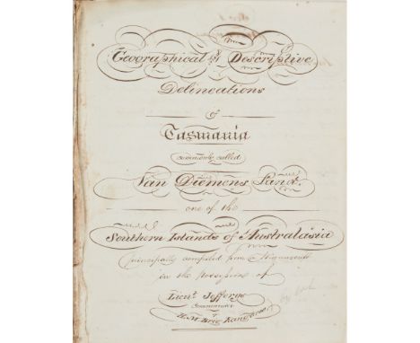
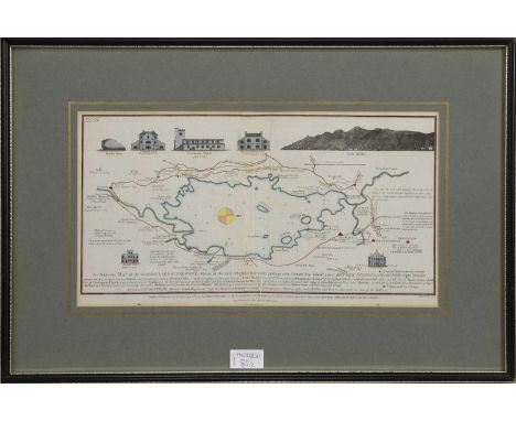
'Geographical and Descriptive Delineations of Tasmania, commonly called Van Dieman's Land, one of the Southern Islands of Australia principally compiled from a Manuscript in the possession of Lieut. Jefferys, Commander of H.M. Brig Kangaroo'. Small 4to (195 x 150mm) Manuscript, 155 pages, in a neat copperplate hand. [paper watermarked 'G. Pike', '1815', '1817', '1814', 'C. Ansell' & '1818'], contemporary calf, spine gilt;Temple, 31st Dec. 1819' and 'Subsequently decided in favor of [ ] in the Court of Common Pleas, W.E.'Note: Charles Jeffreys's book with a slightly different title, Van Dieman's Land. Geographical and Descriptive Delineations of the Island of Van Dieman's Land, was published in 1820 in London by J.M. Richardson, as an octavo and comprised [vi], 168 pages. 'Charles Jeffreys (1782-1826), naval officer and author, was born on 16th October 1782 at Cowes, Isle of Wight, England, the son of Ninian and Mary Jeffreys. He joined the navy at 11 and served as midshipman in various ships before his passing certificate as lieutenant was issued by the Admiralty in August 1803. He was commissioned lieutenant in March 1805. In August 1810 at Lambeth, Surrey, he married Jane Gill of London. In January 1814 he arrived with her at Port Jackson in the brig Kangaroo.Jeffreys's first commission was to transport convicts and other passengers in the Kangaroo from Port Jackson to the Derwent. After an unsuccessful attempt in May 1814 he finally sailed for the Derwent in August and arrived at Hobart Town in October. Instructed to return to Port Jackson by way of Port Dalrymple to collect a cargo of wheat Jeffreys travelled overland, but though the Kangaroo sailed for Port Dalrymple later in October it did not re-enter Port Jackson until February 1815. Governor Lachlan Macquarie was dissatisfied with Jeffreys's explanation of the delay, wanted to send the brig back to England as unfit for service and to discharge Jeffreys, whom he thought a timid seaman and ignorant of his duties; however, in April he dispatched Jeffreys to Ceylon with the remainder of the 73rd Regiment. Whilst on this voyage Jeffreys named Molle Island in the Whitsunday Passage after Lieutenant-Governor George Molle, and Mount Jeffreys on Molle Island after himself. When sailing around Cape York Peninsula in May he discovered and named Princess Charlotte Bay. After his return to Port Jackson in 1816 he made two trips with convicts and stores to the Derwent, which he carried out satisfactorily, but in April 1817 the governor, still critical of Jeffreys's incompetence, reported that he was sending him in the Kangaroo to England. Macquarie instructed him not to touch at any port in either of the colonies, but Jeffreys disobeyed his instructions. He entered Hobart at the end of April under the pretext that he had lost a boat and suffered some damage, but with the real purpose of landing a large quantity of spirits. While the brig was in the Derwent it was learned that several prisoners were missing from Hobart, that two prisoners had been stowed at Port Jackson, and that the escaped Sydney merchant, Garnham Blaxcell, who owed a large sum of money to the government, was on board. When Lieutenant-Governor William Sorell ordered two boats to patrol the river on the evening of 6th May Jeffreys boarded one of them, beat and abused the commander, Captain Jones, and took him and other crew members on board the Kangaroo as prisoners. The captured men were released next day and Jeffreys sailed for England a week later. Macquarie hoped that Jeffreys would be suitably punished, but legal impediments prevented his trial in England; however, at least he had given the British government the means of successfully prosecuting its claims against Blaxcell.While in London Jeffreys arranged for publication of his Geographical and Descriptive Delineations of the Island of Van Diemen's Land in 1820. Most of the information for his work was obtained from the manuscript of Surveyor George William Evans who had travelled in the Kangaroo between Van Diemen's Land and Port Jackson. The book, now rare, was the first of many guides for immigrants intending to settle in Van Diemen's Land.' [Australian Dictionary of Biography, volume 2, 1967].Evans accused Jeffreys of plagiarism in his introduction to the second edition of Evans' own work, A Geographical, Historical and Topographical Description of Van Dieman's Land, with Important Hints to Emigrants, which was first published in 1822. It would appear that the present manuscript is a copy of the copy made by Jeffreys of Evan's manuscript purloined by Jeffreys whilst Evans was on board the Kangaroo. It is conceivable that it could be the actual copy made by Jeffreys (or at his order), with the title suitably worded to make it sound as though it was Jeffreys' own work, or at least with no reference to Evans as being the author. For a biography of George William Evans (1780-1852), see Australian Dictionary of Biography, George William Evans.See also the manuscript lot in this sale by W.C. Wentworth.In May 1820, Jeffreys and his wife returned to Hobart in the Saracen, and later obtained a grant at Pittwater of 800 acres (324 ha), which he named Frogmore. The first house and all its contents were destroyed by fire soon after being built, but he immediately laid the foundations of another. However, Jeffreys did not prosper as a farmer. He died on 6th May 1826 and was buried at Sorell. His widow remained in the colony, and was allowed an additional grant of 500 acres (202 ha).Provenance: William Macpherson, the son of Colonel Allan Macpherson who bought the Blairgowrie Estate which included Newton Castle. He was born in India in 1784 and came to Scotland at the age of three with his parents. He emigrated to Australia in 1829, having spent a decade growing cotton in Berbice in the West Indies. He was Collector of Internal Revenue in New South Wales, and later served (for 24 years) as Clerk of the Councils in New South Wales. He left agents and members of the family in charge of Blairgowrie Estate. He died in 1866 having lived in New South Wales for more than thirty-six years. By descent to the vendor.
Lot 2
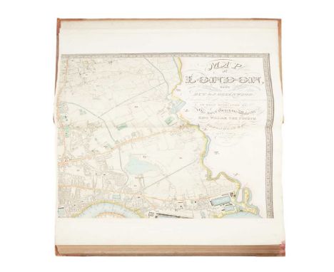
Greenwood, C. & J. Map of London made from an Actual Survey in the Years 1824, 1825 & 1826 Extended and Comprising the Various Improvements to 1830. London: Greenwood & Co., 1830. Wall-size engraved map on 6 sheets (each 65 x 80cm), with contemporary hand-colour, large calligraphic title including dedication to William IV, inset views of St Paul's Cathedral and Westminster Abbey, each sheet folded once and mounted on guard. Bound in at the front of a copy of C. & J. Greenwood's Atlas of the Counties of England, from Actual Surveys made from the Years 1817 to 1833, London: Greenwood & Co., 1834. Large folio, contemporary half morocco, engraved title-page incorporating general map, 46 engraved county maps each with inset view, contemporary hand-colour throughout, all folding and mounted on guards, similarly opening to 65 x 80cm, binding rubbed and marked, spotting to Anglesey [etc.] and Monmouth maps, Northumberland browned [Chubb 458a]Note: Note: Greenwood's landmark map of London was first published in 1827, his only venture outside county map making. His Atlas of the Counties of England and Wales was published in parts between 1829 and 1834. 'It was an astonishing achievement for a private surveyor in so short a time. The majority of these surveys anticipated publication of the sheets of the Ordnance Survey. Even in the south of England and in Lincolnshire, where the Ordnance Survey published their maps first, Greenwood did not slavishly copy the work, but offered a distinctive style and some additional information; not least of the attractions of his maps was the high standard of the engraving ... The enduring popularity of its plates came partly from the beautifully engraved vignettes of cathedrals, castles, or town views that graced each one' (ODNB).
Lot 464
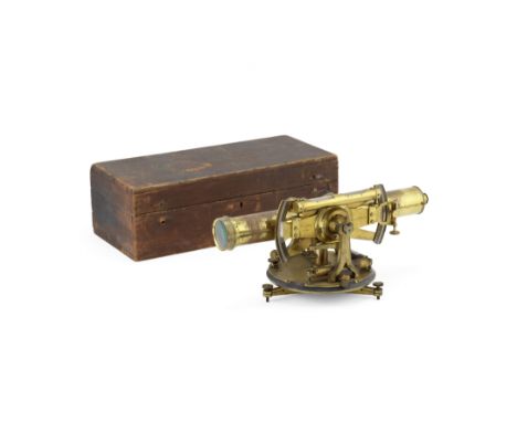
A Troughton & Simms Brass Surveyor's Level, English, Mid-19th century,signed TROUGHTON & SIMMS LONDON, the telescope mounted in a trunnion with twin silver-scale and verniers, and bubble level mounted in parallel, on an associated tripod stand signed BARROW LONDON, in two pine cases, telescope 18in (46cm) long Footnotes:The tripod stand signed 'Barrow' likely refers to the instrument maker Henry Barrow (1790-1870) who was a contemporary of Troughton & Simms. When the Troughton & Simms partnership was established in 1826, Barrow was also working in London, his trade workshop located in Crown Court, Soho. Barrow was mathematical instrument maker to the Surveyor General of India in the 1830's, so it is possible that the Troughton & Simms surveyor's level and Barrow's were compatible with one another.For further information on this lot please visit Bonhams.com

Lot 179
Three framed works and London Survey: Two 19th century gilt framed still life lithographs on embossed card, 37 x 47 cm each; An Italian Printed Broadsheet dated January 18th 1817 relating to a decree by the Governor General of Lombardi Conte Di Saurau, the notice bearing the double-headed eagle device of Italy's Austro-Hungarian ruler's before the establishment of the state under Garibaldi, 60cm x 80cm, all framed and glazed; together with John Rocque Land Surveyor, A Replica of An Exact Survey of the City's of London, Westminster and Borough of Southwark and the Country Near Ten Miles Round Begun in 1741 and Ended in 1745, published by Harry Margary, 1971 (4)
Lot 85
TWO MAPS OF LAKES, PETER CROSTHWAITE, late 18th century, comprising Lake Derwent and Buttermere, Crimmock & Lowes-Water Lakes, both later hand coloured, mounted, framed and under glass, the larger 40.5cm x 73cm overall (2)Note: Crosthwaite '...is considered the founding Father of tourism in Keswick, though those are not the limits to his accomplishments. He was a sailor in the East India Company, an inventor, explorer, surveyor, a husband, a father, customs officer, hydrologist, geographer, cartographer, museum owner and admiral in the Keswick regattas. His revolutionary mindset was the first to recognise and utilises the growing tourist trade in Keswick. Peter Crosthwaite was the definition of a polymath, with a plethora of interests and an insatiable curiosity. He was considered a controversial and eccentric character, though in his eulogy there was nothing but kind things to said about him; it was well known that he and Thomas Hutton had an intense rivalry, due to their museums and their work as guides being in competition. Despite their rivalry, the towns people and visitors enjoyed both museums, though Crosthwaite was the only one with Musical Stones.'
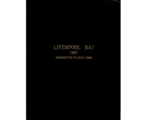
Lot 599
Linen map. Liverpool Bay 1967. Approximately 41 x 34 . Surveyed by the Marine Surveyor of the Mersey Docks and Harbour Board. Contained in attached, smart black boards, titled in gilt. RARE. Linen map. 1967. We combine shipping on all lots. Single book £5.99 UK, £7.99 Europe, £9.99 ROW. We can ship a parcel up to 20kg which will take approx. 40 books in UK £12, EUROPE £39.99, ROW, £59.99
Lot 107
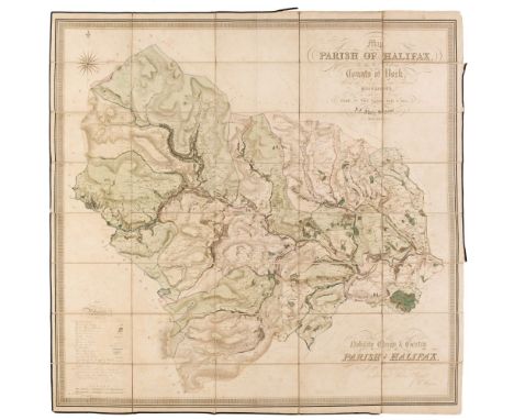
Halifax. Myers (J. F.), Map of the Parish of Halifax in the West Riding of the County of York, Shewing the Township Borough & Manorial Boundaries, from an Actual Survey Made in the Years, 1834 and 1835, by J. F. Myers, Surveyor, Halifax, circa 1835, large scale engraved map with contemporary hand colouring, sectionalised and laid on linen, calligraphic title and dedication, compass rose and a table of references, some light dust soiling and staining, 1075 x 1135 mm,QTY: (1)
Lot 111
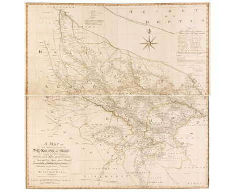
India. Dury (Andrew), A Map of the Provinces of Delhi, Agrah, Oude and Ellahabad, Comprehending the Countries lying between Delhi and the Bengal-Provinces, surveyed by Major James Rennell, Surveyor General to the Honourable East-India Company and Published by the Order of the Court of Directors of the said Company, Laurie & Whittle, 12th May 1794, engraved map with contemporary outline colouring, on two sheets, not conjoined, slight offsetting, narrow margins, one short closed tear to the upper sheet, each sheet approximately 545 x 1065 mmQTY: (1)
Lot 127
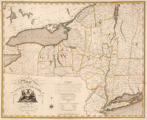
New York State. De Witt (Simeon), A Map of the State of the State of New York by Simeon De Witt, Surveyor General, Contracted from his Large Map of the State, New York, 1804, engraved map with contemporary outline colouring, large inset title cartouche and compass rose, old folds, some adhesion scaring to verso, a few folds strengthened and repaired on the verso, slight marginal fraying and creasing, 565 x 690 mmQTY: (1)NOTE:Ristow. American Maps and Mapmakers, pages 73-83. Rare. Copac lists only one institutional copy (British Library), although we have found other copies at Yale and The Centre for Brooklyn History.
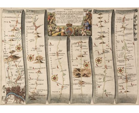
![Ogilby (John). The Road from Oxford to Cambridge [1676 or later], hand-coloured engraved strip road map, decorative cartouche](https://cdn.globalauctionplatform.com/2a43871f-d280-4166-9f6c-af8800c0bef7/d9605558-4665-4a1a-80a3-af8900a97b3a/468x382.jpg)
Lot 133
Ogilby (John). The Road from Oxford to Cambridge [1676 or later], hand-coloured engraved strip road map, decorative cartouche showing a surveyor using a waywiser, three margins strengthened on verso, one repaired closed tear, slight toning, 345 x 415 mm, together with The Road from Oxford to Coventry continued to Darby [1676 or later], hand-coloured engraved strip road map, decorative cartouche, slight creasing, 340 x 450 mmQTY: (2)NOTE:Sheet numbers 80 & 82 respectively.
Lot 401
Salmon (William). Palladio Londinensis; or, the London Art of Building, in three parts, 4th edition, with great alterations and improvements, by E. Hoppus, Surveyor to the Corporation of the London Assurance, London: printed for S. Birt, T. Longman, C. Hitch, J. Oswald and others, 1752, 52 engraved plates, some folding, one or two closed tears and repairs, a few frayed fore margins, contemporary calf, some wear with joints cracked, 4to, together with[Carter, John]. The Builder's Magazine: or, Monthly Companion for Architects, Carpenters, Masons, Bricklayers, &c. as well as for every gentleman who would wish to be a competent judge of the elegant and necessary art of building, consisting of Designs in Architecture... by a Society of Architects, 1st edition, volume 1 only (of two), London: printed for the Author; and sold by F. Newbery, 1774, 75 engraved plates, including several folding and one-coloured, title laid down with some soiling and tears, water stain to first few leaves, contemporary calf-backed boards, some wear, 4to, plus 3 others: B. & T. Langley's The Builder's Jewel, 10th edition, 1763, William Pain's The Practical House Carpenter, 6th edition, 1799, and Batty Langley's The Builder's Director or Bench-Mate, circa 1792 (covers detached)QTY: (6)NOTE:Harris 796; 67; 436; 656; 430 respectively. The complete work contains 185 plates.
![[MAP] HANSON (Thomas) surveyor: "Plan of Birmingham Survey'd...1778", large map on 2 sheets joined, engr. by J. Roe, mounted](https://cdn.globalauctionplatform.com/11849aff-3fd4-4d74-98b7-af880105a156/2ab886db-094b-4eba-917f-af88010f69dd/468x382.jpg)
![[Rathborne (Aaron)] [The Surveyor in Foure bookes], first edition, lacking engraved title and portrait of Prince Charles (bot](https://cdn.globalauctionplatform.com/1bc452bc-6d53-48a0-a003-af8600b43a80/f896b476-89d9-4d20-b8e5-af8600cbd738/468x382.jpg)
Lot 70
[Rathborne (Aaron)] [The Surveyor in Foure bookes], first edition, lacking engraved title and portrait of Prince Charles (both supplied in facsimile) but with engraved portrait by S.Passe at end, woodcut head-pieces, initials, illustrations and diagrams, O3 a cancel with "58 4/5" in line 5 on verso and mounted on stub (slightly frayed at lower edge), very occasional light soiling or staining, contemporary sheep, rubbed and scuffed, rebacked preserving old spine, new endpapers, [Fussell I, pp.22-23; STC 20748], folio, by W. Stansby for W. Burre, 1616 § [Moxon (Joseph) A Tutor to Astronomy and Geography...], third edition, lacking half-title and letterpress title (both supplied in facsimile) but with additional engraved title, engraved and woodcut illustrations, occasional soiling, Foyle copy with leather book-label, modern half red morocco, [Wing M3024], Tho. Roycroft, for Joseph Moxon, 1674, folio & 4to; sold not subject to return (2)⁂ The first is the first comprehensive English textbook on surveying.
Lot 1213
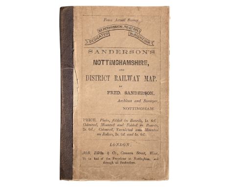
Frederic Sanderson (Architect and Surveyor, Nottingham), Sanderon’s Nottinghamshire, and District Railway Map/Poor Law Union and Parish Map of the County of Nottingham, Exhibiting in a Comprehensive Manner the Railway System of the District, London: Published by Job, Bros. & Co., 1st Dec:r 1861, engraving laid on linen, hand-coloured delineation, 20 folds, 72cm x 53.5cm, original publisher’s cloth-backed printed boards, the pastedown of which with adverts. The folds a little worn, principally the central horizontal one. The lower-right vignette of Clumber with a scuffed loss, ditto – but smaller – to its opposite upper-right. The boards gently bumped and rubbed, split but stable back.
Lot 88
GI Joe - Action Man - Palitoy - Hasbro - Others - Four GI Joe / Action Man modern boxes each containing a quantity of loose mainly Action Man and GI Joe weapons and accessories. Equipment included in the boxes includes Action Man Engineers Surveyor theodolite with tripod; 81mm Mortar; M16; Browning machine gun; radios, map canister; flag; jungle knife and similar. Boxes have some storage related wear appearing Good overall and DO NOT CONTAIN FIGURES. Items within boxes show play and age ear, generally ranging Fair Plus - Very Good and are unchecked for completeness. Kit bags are filled with packaging only and do not contain accessories (4) (This does not constitute a guarantee)Condition Report - The MP radio featured in this lot does NOT posses any makers marks. It is blank to the rear - please refer to photograph showing comparison with normal field radio.
Lot 143
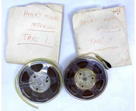
Henry Moore (1898-1986). Recorded interview on two reel-to-reel tapes, approximately 60 minutes in length, also converted to digital USB, tog. w/ photographs of Tittenhurst Park (where the recordings were discovered) taken during renovations in 1989, and architect plans/copies of drawings for a proposed home & recording studio for John Lennon on his private island, Dorinish Island, which appear Space Age and almost psychedelic in their design. The Henry Moore Foundation has very kindly identified the recording for us, which they say appears to have been made in 1967 in Moore’s home Hoglands. From their bibliography, the Foundation has identified the article the interview was made for, namely, The Venerable Henry Moore, an Oxford University magazine report of an interview with Moore, mainly on his choice of stone and method of work in Italy. In the recordings, Moore is very generous in his responses to the interviewer's questions, giving lengthy, considered answers that provide a valuable insight into his work. One can only guess why the recordings were abandoned at Tittenhurst Park or if they were ever owned or acquired by John Lennon during his residence there [1969-71]. The photographs in this archive include images of a Tudor building on the Tittenhurst estate, now sadly gone, which was described as 'the party house'; the interior walls are adorned with graffiti, with one daubing - a Samuel Johnson quotation - being signed 'Paul', and we can only speculate if this may have been Paul McCartney. A unique archive that was rescued from destructionProvenance: The vendor has kindly provided the following statement for inclusion in our catalogue: 'These lots were rescued in 1989 from a builder's skip on a major reinstatement project of Tittenhurst Park estate, nr Ascot, former residence of John Lennon. I was the senior site quantity surveyor acting on behalf of the new owner and they have been in safe storage ever since.'NB. Anyone seeking to commercially publish the material would need to have permission from both copyright holders prior to use, namely The Henry Moore Foundation, and Oxford Student Publications Ltd
Lot 53
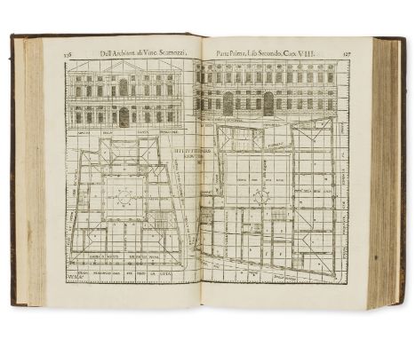
NO RESERVE Scamozzi (Vincenzo) L'Idea della Architettura Universale, 2 parts in 1, first edition, additional engraved architectural titles incorporating portrait of the author, letterpress titles with large woodcut device, woodcut head- & tail-pieces and initials, numerous full-page woodcut illustrations, some double-page, 44 full-page engraved illustrations, 5 double-page, with 2 blank leaves but lacking Register leaf (p.371) at end (as often), plate on p.62 of Book 6 not pasted over, first engraved title lightly soiled, otherwise an excellent clean copy, engraved bookplate of Thomas Worsley Surveyor General of His Majesty's Works, eighteenth century calf, rubbed, a few scuffs and gouges, rebacked in morocco, spine gilt, corners repaired, new endpapers, [Berlin Kat. 2605; Fowler 292; Millard Italian 123], folio, Venice, Giorgio Valentino, 1615.⁂ After Palladio's Quattro Libri this was the most influential architectural work of the early seventeenth century.Thomas Worsley (1711-78), of Hovingham Hall, Yorks., landowner, horse-breeder and amateur architect who was Surveyor of the Office of Works from 1760 until his death. He designed the stables at Marske Hall near Richmond, Yorks., for John Hutton and his own Hovingham Hall with its unusual entrance via a manège.
Lot 154
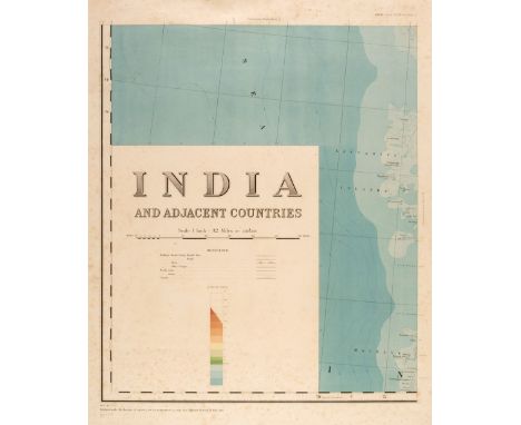
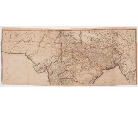
India. Burrard (Colonel Sir S. G. publisher). India and Adjacent Countries, Published under the direction of Colonel Sir S.G. Burrard, K.C.S.I.R.E., F.R.S., Surveyor General of India, Calcutta, 1915 but 1922 re-issue, colour printed large scale map (1 inch - 32 miles) printed on 12 sheets, each sheet with a small punch-hole in the margin with an indicative tag attached to show its eventual position, some spotting and marginal fraying to the margins, each sheet's overall size 785 x 675 mmQTY: (12)
Lot 190
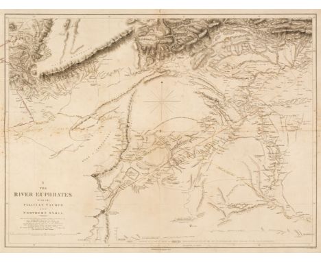
River Euphrates. Chesny (Colonel Francis Rawson, surveyor), Twelve map sheets, 1849, twelve double-page maps, engraved by J & C Walker, slight spotting, old folds, backed with near-contemporary silk, each approximately 475 x 630 mmQTY: (12)NOTE:The Euphrates expedition was led by a British army officer, Colonel Francis Rawson Chesney. The main objective was to establish a route “between the Mediterranean Sea and His Majesty’s possessions in the East Indies by means of a steam communication of the river Euphrates”. Finding a shorter route to India was the hot topic of the time. The East India Company particularly, needed a solution to cut down the travel time between England and India. Chesney was involved in initial surveys in Egypt and the Middle East in the late 1820s where he had investigated the possibility of passage to India via the Red Sea and in 1829, submitted a report advocating the construction of the Suez Canal. He also brought to attention the feasibility of steam communication with India through the Euphrates. King William IV himself expressed a desire that the route by the Euphrates to India should be put to a practical test. The main task involved determining the depth, current and state of the river and this wealth of data was used in the compilation of detailed charts of the region’s waterways from the Mediterranean to the Persian Gulf.The Euphrates project was shelved and the shorter route to India was eventually established in late 1869 via the Suez Canal. Nevertheless, Chesney’s survey proved an invaluable source of information on the region’s hydrography.
Lot 62
Stokes (John Lort). Discoveries in Australia; with an account of the coasts and rivers explored and surveyed during the Voyage of H.M.S. Beagle in the years 1837-38-39-40-41-42-43. By Command of the Lords Commissioners of the Admiralty. Also a narrative of Captain Owen Stanley's visits to the islands of the Arafura Sea, 1st edition, 2 volumes, London: T. and W. Boone, 1846, 26 engraved and lithographed plates, 8 folding maps (6 in front pockets), advertisements to front and rear of both volumes (including small inserts), neat ownership inscriptions of E.C. Gore to front pastedowns, small initials to upper margins of titles, rear pockets renewed, lightly spotted, original blindstamped blue cloth gilt, rebacked with original spines laid on, rubbed and lightly marked, 8voQTY: (2)NOTE:Ferguson 4406; Wantrup 89a.Provenance: Edward Clive Gore (1887-1938), possibly descendant of Lieutenant Graham Gore who participated in the expedition. Purchased by John Betjeman and given to Peter Stewart in 1963 (signed ALS from Betjeman included).The work documents the third and final circumnavigation of HMS Beagle from 1837 to 1843 under Wickham and Stokes. Stokes was previously assistant surveyor on the Beagle's second expedition, of which Charles Darwin was a part. The expedition comprehensively mapped the Australian coastline, as well as the Arafura Sea.
Lot 79
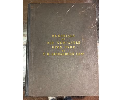
Richardson (Thomas Miles). Memorials of old Newcastle upon Tyne ... comprising forty etchings from original drawings of the towers, gateways, churches, streets and ancient buildings of Newcastle upon Tyne in the early part of the present century, nearly all of which have been removed, Edinburgh: Thos. Gray & Co.; Newcastle on Tyne: James Garland, [1880], lithograph title with signature J.H. Horsley to upper margin, 42 etched & engraved plates, occasional light spotting, original cloth, rebacked, few marks, folio, together with:Richardson (Thomas Miles), Antiquities of the Border Counties from original drawings by T. M. Richardson, Senr. with descriptive letterpress to which is added a reprint of Grey's Chorographia, Edinburgh: T. Gray & Co.; Newcastle on Tyne: J. Garland, 1881, lithograph portrait frontispiece, illustrated title and 20 mounted etched plates (two plates frayed to margins and detached), occasional light spotting and minor dust-soiling, all edges gilt, original cloth, light fraying to extremities, folio,Surtees (Robert). The History and Antiquities of the County Palatine of Durham, 4 volumes, facsimile reprint, Wakefield: E.P. Publishing, 1972, numerous monochrome illustrations, original cloth in dust jackets, folio, together with other facsimile reprints including Drake (Francis), Eboracum: or, the History and Antiquities of the City of York, facsimile reprint, Wakefield: E.P. Publishing, 1978, monochrome map & plates (some folding), illustrations, original cloth in dust jacket, folio, and Nicolson (Joseph & Burn, Richard), The History and Antiquities of the counties of Westmorland and Cumberland, 2 volumes, facsimile reprint, Wakefield: E.P. Publishing, 1976, two monochrome folding maps, original cloth in dust jackets, 4toQTY: (9)NOTE:Provenance: Sir William Whitfield CBE (1920-2019), one of the most significant British architects of the second half of the 20th century, notable for his ground-breaking designs for major public projects including Glasgow University Library, the Hunterian Art Gallery (1960-1968), Richmond House in Whitehall (1982-1984), recently selected as one of London’s ten most iconic Postmodern Buildings, Hereford Cathedral’s Mappa Mundi Library (1996), and Hawksmoor’s Baroque masterpiece Christ Church Spitalfields, slowly and carefully restored over three decades from 1970 to 2000 under his direction. He was Surveyor of the Fabric of St Paul’s Cathedral between 1985 and 1990.
Lot 241
India.- Laurie & Whittle (publishers) A New Map of Hindoostan from the latest authorites made by Major James Rennell, Surveyor General to the Hble. East India Company, of the Bengal provinces and of the Countries lying between them and Dehly..., large engraved map with outline colouring, presented in two horizontal sections, each section approx. 610 x 1400 mm (24 x 55 1/8 in), old folds, some splitting and loss associated to folds, heaving spotting and browning, handling creases, nicks and tears, unframed, 1794; together with a good group of maps of India, including 'A Map of the Northern Part of Hindoostan or A Geographical Survey of the Provinces of Bengal, Bahar, Awd, Ellahabad, Agra, and Dehli', 1794, with some losses and tears to map, and with 4 others by Thomson, Kitchin, and another, various sizes, unframed, 18th and 19th century (6)
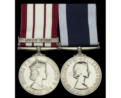
Lot 270
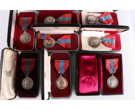
Pair: Acting Chief Petty Officer J. Todd, Royal Navy Naval General Service 1915-62, 1 clasp, Near East (P/JX. 882559 J. Todd. A.B. R.N.); Royal Navy L.S. & G.C., E.II.R., 2nd issue (JX.882559 J. Todd. A/C.P.O. H.M.S. Vidal.) mounted as worn, light polishing and contact marks, otherwise good very fine (2) £160-£200 --- H.M.S. Vidal was a survey ship in the Royal Navy and was unarmed except for four 4-pdr saluting guns and the first small ship designed to carry a helicopter. She was launched at Chatham on 31 July 1951, and broken up at Bruges in June 1976. Named after the nineteenth century surveyor Alexander Vidal, who had surveyed much of the coast of Africa, the crew of the ship formally annexed the islet of Rockall on 18 September 1955.
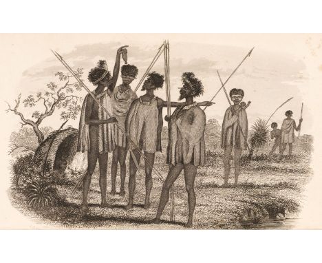
Lot 612
George Victor Du Noyer (1817-1869) Watercolours of Ireland’s Geological Landscapes This folio of ten large watercolour drawings by George Victor Du Noyer provides an insight into the work of a remarkable artist, who devoted his life to the advancement of science and art in nineteenth-century Ireland. Born in Dublin in 1817, of French Huguenot descent, Du Noyer was a prolific watercolourist, geologist and antiquarian. Over the course of his lifetime, he produced thousands of drawings documenting the landscapes, geological formations, antiquities and general life of the towns and countryside of Ireland. Du Noyer’s employment with the Ordnance Survey began when, aged seventeen, he was apprenticed to George Petrie, head of the Topographical section. In 1848 he was appointed assistant at the Geological Survey of Ireland, working under Thomas Oldham. The expansion of the railway network in Ireland during these years resulted in cuttings being made through rock, exposing valuable geological information. Du Noyer made drawings of many of these cuttings, then spent the next two decades traversing the Irish countryside as a geological surveyor, working mainly in counties Waterford, Wexford, Cork and Kerry, as well as Co. Antrim, Down and Armagh. Between 1841 and 1863, he exhibited forty-eight paintings at the RHA, as well as contributing illustrations to all's "Ireland" and Joseph Portlock's Geological Report on Londonderry, Tyrone and Fermanagh. His drawings were also used to illustrate Roderick Impey Murchison's Siluria, Joseph Beete Juke's Popular Geology and other publications. Du Noyer’s Huguenot roots were important to him, and in 1858, aged forty-one, he married Frances Adélaide Du Bédat. They had five children, the youngest being Henry Westropp. In 1867 he became the first District Surveyor of the Geological Survey, moving to Carrigfergus, Co. Antrim. However, while surveying he contracted scarlet fever, and died on 3rd January 1869, just one day after his daughter Fanny had died of the same disease. They were both buried in the graveyard adjoining All Saint's Parish Church, in Co. Antrim. After his death, his widow offered his collection of drawings, contained in twelve volumes, to the Royal Irish Academy, where they remain today. The other main collection of his work is held by the Geological Survey of Ireland, with the result that works by Du Noyer are comparatively rare on the open market. The first watercolour in the Fonsie Mealys' folio, Ancient River Course at Bagnelstown, is inscribed on verso “Ancient River course in granite near Bagnelstown, Co. Carlow. View of the site of great waterfall, looking up the gully.” Although signed and dated March 1857, it relates to a group of similar sketches (now in the Geological Survey of Ireland collection), made in September 1848 when George Du Noyer was in the Bagnelstown area. As with many of his landscape drawings, it includes figures of surveyors at work, examining and measuring the rocks. Another watercolour in the Fonsie Mealys' folio,Tilted Slabs, depicts large inclined slabs of stone in a coastal landscape, and is dated December 1857. The location is not identified but may be the Old Red Sandstone quarries at Carnivan Head in Co. Wexford. In Columnar Basalt, a third drawing in the folio, du Noyer, with characteristic brio, depicts a rowing boat braving the waves on the coastline of Co. Antrim. Visible in the foreground, battered by the seas, are hexagonal basalt formations, similar to those at the nearby Giant’s Causeway. The date of this watercolour is almost certainly 1857, when du Noyer visited the Giant’s Causeway in preparation for writing an article, which was duly published three years later, in The Geologist journal. A related drawing in the Fonsie Mealys' folio, Dunluce, is dated August 1857, and depicts what is likely the same rowing boat, beneath the cliffs near Dunluce, in Co. Antrim. The soft chalk cliffs have been eroded by the sea, but the columns of harder basalt stone stand proud. Granite River Bed depicts two surveyors working in an area of complex geology. Visible on the right hand side is a section of granite rock that still bears the marks of having been, as Du Noyer notes in an inscription on the verso, ‘rounded and furrowed’ by the action of running water. Beyond is a valley strewn with large boulders. As the new railway extended north from Dublin towards Belfast, du Noyer followed the line of the track, sketching newly-exposed walls of stone. A watercolour in the Fonsie Mealys' folio, Dundalk and Enniskillen Railway Cutting, with the railway line in the foreground, also includes a self-portrait of the artist, holding a drawing book. This relates to a similar drawing of a cutting on the same line, Trapped Dyke, which was reproduced in Beete Jukes’ 1853 Popular Physical Geology. Another important geological location north of Dublin can be found on the coastal cliffs of Loughshinny, between Skerries and Rush. The dramatic folded layers at Loughshinny are depicted by du Noyer with great accuracy in a watercolour which is a finished version of his woodcut illustration in Beete Jukes’ 1862 The Student’s Manual of Geology. Signed and dated 1857, the watercolour Dingle Harbour Cliffs shows dramatic cliffs, with vertical strata. The view is probably taken looking south from near Ferriter’s Cove, over fossil-bearing rocks of the Silurian period. Another Du Noyer watercolour of the Dingle Peninsula, Dingle Promontory, depicts a geological formation known as ‘The Acadian Unconformity’, where horizontal Middle Devonian rocks overlie older, Lower Devonian strata. Also visible is the sea stack known as “An Searrach” near Kinard Beach. This watercolour probably also dates to 1857. As a portfolio, w.a.f. (10) Dr. Peter Murray, 2022

Lot 9029
Edward Stanford: 'India and Adjacent Counties - Baroda', folding colour lithographic map, 1917, published under the direction of colonel S.G. Burrard, Surveyor General of India, sheets 41 and 46, covering roughly the area of the present day state of Gujarat, approx 57 x 91cm, folding into original covers, printed paper label to front cover
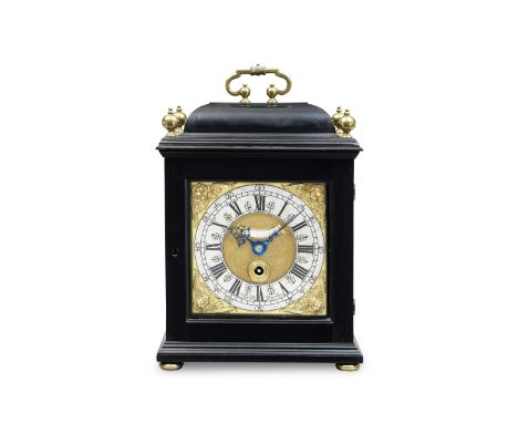
Lot 78
A FINE LATE 17TH CENTURY EBONY VENEERED QUARTER-REPEATING TABLE TIMEPIECELangley Bradley, LondonThe caddy top with tied bud handle and four ball finials over a well-moulded cornice and base on button feet. The 6.75-inch dial framed by well-cast winged cherubs' head spandrels framing the silvered chapter ring, the periphery of which has Arabic five-minute numerals interrupted by half-quarter marks, around a minute band and Roman hour ring with fancy half-hour markers, the finely matted centre with chamfered mock pendulum aperture and signature between V and VII. The single gut fusee movement with knife-edge verge escapement repeating the hours and quarters on three bells and hammers via the repeat cord to the side, the backplate framed by a stylised wheatear border with shaded corners enclosing a series of symmetrical anemones within foliate scrolls, signed in an open reserve in copperplate script Langley Bradley, London. Ticking and repeating. 38cms (14.5ins) high.Footnotes:Sir Christopher Wren was a key supporter of Bradley's and may have influenced the decision to award him the contract for the new clocks at St Pauls Cathedral, Hampton Court and another in the Admiralty Building. King William III presented a Bradley watch to Wren on completion of St Pauls.Langley Bradley was born in Stepney in 1671, the second of five children born to Martha Curtus and Thomas Bradley, a gardener. In 1688, Langley was apprenticed to Joseph Wise, a member of a well-known horological family. His brother, Thomas Wise, seems to have known Joseph Windmills in some capacity, the latter of whom served as surveyor for Thomas' will. Three months after Thomas' death in 1696, his widow Ann, married Langley Bradley, who had gained his freedom a year earlier. This meant that Bradley was able to buy out Thomas' son's entitlement to his father's tools and materials; the inventory included a number of clock and watch movements, cases and a large clock which hung above the shop in the street. This clock gave Wise's house and shop its name, the Minute Dyall, in Fenchurch Street: Bradley is recorded as working here after his marriage, having previously worked in Whitechapel. The same year, 1696, Bradley assisted William Derham in his writing of the landmark book The Artificial Clockmaker. In 1706, Benjamin Bradley was born; Benjamin was apprenticed to his father in 1721, eventually being made partner in 1728. In 1726, Bradley became a Master of the Clockmakers Company, a position he would hold until 1748. Interestingly, Aynsworth Thwaites, who would go on to establish the Thwaites clock company, was apprenticed to Benjamin Bradley in 1735. The output of the Minute Dyall under the Bradleys was quite diverse, including longcase clocks, lantern clocks, bracket clocks, and watches. The firm also supplied a large number of turret clocks, using techniques Bradley possibly learned as an apprentice from his master's father, a noted turret clock maker. Seventeen turret clocks are known to have been made by Bradley, including one at Blenheim Palace, installed in 1710, whose escapement was later modified by Vulliamy, and one at St. Magnus the Martyr church by London Bridge, installed in 1709. Both these clocks are still working, though the clock for St. Magnus the Martyr has had the striking train disabled. He also maintained several turret clocks he didn't supply, including one supplied by Edward Stanton to the Royal Exchange. His turret clock work was not confined to London, ranging as far afield as Cambridge and Oxford; he is also known to have manufactured his own specialty tools to help him with his turret clock manufacture. Perhaps his most famous project, however, was supplying the original turret clock to St. Paul's cathedral in 1707. It was a massive undertaking, especially as it was desired that the clock should strike and run for eight days on a single wind. Unfortunately, the clock was plagued with time keeping problems; Bradley himself blamed the public, who were allowed to view the clock movement and apparently couldn't resist trying to ring the bell. A contemporary account, however, suggests that the movement itself was not robust enough to deliver the necessary power to drive the very large hands. Consequently, the clock was removed in 1717, and replaced with a thirty-hour clock by Wright and Street. Despite this, Bradley was still appointed Keeper of the Clock for St. Pauls in 1738, a position he held until his death.Benjamin worked at the Minute Dyall until his untimely death in 1744. A year later, the 74-year-old Langley Bradley moved back to Stepney; he continued to maintain a variety of turret clocks, though he no longer worked from a shop. He died in 1753, and the entirety of his estate was passed to his sole living child, Margaret Renard (née Bradley). She would also receive the final payment from St. Dunstan's Church, for Langley Bradley's work on maintaining their turret clock.Hodgson, B. (2002) 'Langley Bradley-'A Judicious Workman' Part I: Historical Details & Domestic Output', Antiquarian Horology, Vol. 26 (5), pgs. 477-499.Hodgson, B. (2002) 'Langley Bradley-'A Judicious Workman' Part II: Turrett Clocks', Antiquarian Horology, Vol. 26 (6), pgs. 611-625.Hodgson, B. (2002) 'Langley Bradley-'A Judicious Workman' Part III: St. Paul's Cathedral', Antiquarian Horology, Vol. 27 (1), pgs. 35-51.For further information on this lot please visit Bonhams.com
Lot 190
Bell (John). Account of Queen Victoria passing through Newcastle upon Tyne, on Friday 28 September 1849, circa 1850, frontispiece, manuscript title with onlaid printed vignette, mounted newspaper articles throughout, numerous tipped-in folding broadsides, numerous lithograph illustrations, bookplates to front pastedown, light spotting and dust-soiling, hinges cracked, 20th-century burgundy half calf gilt over brown marbled boards, lightly rubbed, 4to, contained in custom slipcaseQTY: (1)NOTE:Provenance: John Bell, antiquary and surveyor, (1783-1864, his sale). Joseph Crawhall, artist (1861-1913, his sale). Matthew Mackey, bookplate. R.W. Martin, bookplate.An interesting volume compiled by John Bell for Queen Victoria's visit to Newcastle in 1849, containing a wide range of ephemeral items.
Lot 359
* Pepys (Samuel, 1633-1703). English diarist and naval administrator. Document Signed, ‘Samuell Pepys’, Navy Office, 5 April 1661, warrant addressed to William Sheldon, Clerk of the Cheque of the naval yard at Woolwich, for an order from his Royal Highness James Duke of York &c. Lord High Adm[ira]l of England, ‘dat[ed] 3rd instant These are to pray and require you to enter Dan[ie]l Kempe boatswaine of his Ma[jest]ys Shipp the Yarmouth with such allowance of wages and victuals for himselfe and his servant as is usuall and propper for the Boatswaine of his Ma[jest]ys, said shipp…’, signed at foot of text by Pepys and three others, Robert Slingesby, William Batten and William Penn, some spotting and light old dampstaining (affecting Penn’s autograph), 1 page with integral blank, endorsed, tipped onto a paper mount, folioQTY: (1)NOTE:Signed by Pepys, (unusually with his full first name), as Clerk of the Acts to the Navy Board. Pepys’s Diary (pepysdiary.com) for 5 April 1661 reads:‘Up among my workmen and so to the office, and then to Sir W. Pen’s with the other Sir William and Sir John Lawson to dinner, and after that, with them to Mr. Lucy’s, a merchant, where much good company, and there drank a great deal of wine, and in discourse fell to talk of the weight of people, which did occasion some wagers, and where, among others, I won half a piece to be spent.Then home, and at night to Sir W. Batten’s, and there very merry with a good barrell of oysters, and this is the present life I lead.Home and to bed.’Sir Robert Slingsby, 1st Baronet (1611–1661), naval commander and Comptroller of the Navy, and in his last years a much-loved colleague of Samuel Pepys.Sir William Batten (1601-1667), naval officer and administrator. As Surveyor of the Navy he was a colleague of Samuel Pepys, who mentions him frequently in his ‘Diary’, often to his detriment.Sir William Penn (1621-1670), English admiral and politician. In 1660 he was appointed a Commissioner of the Navy Board where he worked with Pepys. He was the father of William Penn, founder of the Province of Pennsylvania.
Lot 420
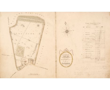
Suffolk Estate Plans. Plans of Estates in Easton, Letheringham & Charsfield in the County of Suffolk; The Property of the Rt. Hon: The Earl of Rochford, 1794, Survey'd & Plann'd by Isaac Johnson, Woodbridge, Suff., continued down to 1830, calligraphic title, half-title and summary of the estate with reference to each farm &c, followed by 10 pen and ink and watercolour wash estate plans with cartouches and table of contents giving field names with gross and nett areas in terms of acres, roods and perches, each 48.5 x 30 cm when opened, a few scattered light pencil annotations and some dust soiling, mostly re-guarded with linen strips, late 19th-century burgundy roan, upper cover stamped 'Plans' in gilt, heavily rubbed, 4to (32 x 26 cm)QTY: (1)NOTE:The ten plans are for: The Park, The Property of the Earl of Rochford; Martley Hall: Mrs Plant; Bonds; Richard Levett; Bentries & Cobbs: Stephen Catchpole (2 maps); The Lodge: William Cooper; Old Hall: Joseph Amoss; Wood grounds: Earl of Rochford &c; Detached lands; Sundry people; General view of the Parishes of Easton and Letheringham. A further five farms are listed at the foot of the contents summary but in such a way as to imply these were not to be included in the present survey.Isaac Johnson (c. 1754-1835) was the son of the surveyor John Johnson (1722-1780), and his wife Mary. He was baptized at Pettistree, Woodbridge, Suffolk. He was probably trained by his father at Alderton, Suffolk, and probably worked with him, as this album suggests, until John's death in 1780. In 1772 he opened a writing school at Alderton and then in 1784 moved to Woodbridge where he married Elizabeth Maxwell. His account book for 1791-1796 survives and shows that he had 165 clients, earning £1,069 in surveying fees for these five years. His fine draughtsmanship led him to draw all the churches and various other antiquities of Suffolk.
Lot 629
8 Elizabeth II Imperial Service medals to include: Elizabeth II (Tudor crown BRITT OMN variety 1953-54 c.9,000 issued) Imperial Service medal [ROBERT FRANCIS GILES], in Royal Mint issue box, Elizabeth II (Tudor crown DEI GRATIA variety 1955-, c.150,000 issued) Imperial Service medal [ALBERT EDWARD SMITH], in fitted issue case, Elizabeth II (Tudor crown DEI GRATIA variety 1955-, c.150,000 issued) Imperial Service medal [JOHN HENRY WILLCOCKS], in Royal Mint issue case, Elizabeth II (Tudor crown DEI GRATIA variety 1955-, c.150,000 issued) Imperial Service medal [MISS SHEILA ANN HUTCHISON NIVEN], in Royal Mint issue case, Elizabeth II (Tudor crown DEI GRATIA variety 1955-, c.150,000 issued) Imperial Service medal [MISS ELEANOR VICTORIA PATRICIA WARNER], in Royal Mint issue case, Elizabeth II (Tudor crown DEI GRATIA variety 1955-, c.150,000 issued) Imperial Service medal [ARTHUR ROBERT BOYD], in Royal Mint issue case with typed note 'Cartographic Surveyor, Senior Grade, Ordnance Survey Department', Elizabeth II (Tudor crown DEI GRATIA variety 1955-, c.150,000 issued) Imperial Service medal [JOSEPH FERGUS], in Royal Mint issue case, and Elizabeth II (Tudor crown DEI GRATIA variety 1955-, c.150,000 issued) Imperial Service medal [FRED CAIRNS MURRAY], in Royal Mint issue case. (8)

Lot 129
Wyld (James). Maps & Plans, Showing the Principal Movements, Battles & Sieges, in which the British Army was engaged during the War from 1808 to 1814 in the Spanish Peninsula and the South of France, [1840], engraved title and dedication, contents page printed in blue, 39 lithographed maps and plans, (7 double-page, 4 with fold-out extensions, 4 with movable flaps), many with hand-coloured troop positions and some geographical features, some light spotting throughout, some mostly short marginal tear repairs to versos without loss, ink presentation inscription to title, 'Presented to D. Captain Adjutant General for Instruction, South Eastern District, by Col. C[harles] J[ohn] Cramer Roberts [1834-1895], late 9th (Norfolk) Regiment, Feb. 1895', original red half morocco, gilt red morocco label to upper cover, heavily rubbed and slightly soiled, atlas folio (85 x 69 cm), together with:Memoir Annexed to an Atlas Containing Plans..., London: James Wyld, 1841, index/errata leaf and publisher's advert leaf at rear, occasional spotting, all edges gilt, contemporary half morocco, slightly rubbed, 4to (30.5 x 23.5 cm)QTY: (2)NOTE:First and only edition of this colossal and uncommon atlas, the maps being the meticulous work of the surveyor Thomas Livingston Mitchell (1792-1855). The Memoir was issued to accompany the atlas, and due to size incompatibility and different publishing dates it is scarce to find both volumes together.
Lot 172
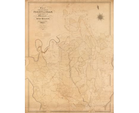
Gloucestershire. Atkinson (John), Plan of Her Majesty's Forest of Dean, in the County of Gloucestershire, with High Meadow and Great Doward Woods, by John Atkinson, Mineral Surveyor, one of the Deputy Gavellers of Her Majesty's Forest of Dean,1842, large map, engraved by J & C Walker, with contemporary outline colouring, on four conjoined sheets, the whole laid on linen, calligraphic cartouche, compass rose and table of explanation, slight overall toning, 1350 x 1060 mm, presented on a contemporary turned wooden roller attached to the lower marginQTY: (1)NOTE:Scarce.
Lot 353
Ackermann (Rudolph). The History of the Abbey Church of St. Peter's Westminster, its Antiquities and Monuments, 2 volumes, London: Printed for R. Ackermann, 1812, half titles, subscribers list, engraved portrait and plan, 81 hand-coloured aquatint plates, occasional light offsetting and spotting, top edge gilt, later handsome crimson morocco by Bayntun Riviere, Bath, covers with geometric design in blind and gilt, spines with raised bands, letterd and decorated in gilt, spine ends slightly rubbed, 4to QTY: (2)NOTE:Abbey Scenery 213-214; Tooley 2.Provenance: Sir William Whitfield CBE (1920-2019), one of the most significant British architects of the second half of the 20th century, notable for his ground-breaking designs for major public projects including Glasgow University Library, the Hunterian Art Gallery (1960-1968), Richmond House in Whitehall (1982-1984), recently selected as one of London’s ten most iconic Postmodern Buildings, Hereford Cathedral’s Mappa Mundi Library (1996), and Hawksmoor’s Baroque masterpiece Christ Church Spitalfields, slowly and carefully restored over three decades from 1970 to 2000 under his direction. He was Surveyor of the Fabric of St Paul’s Cathedral between 1985 and 1990.
Lot 354
Brand (John). History and Antiquities of the town and county of the town of Newcastle upon Tyne, 1st edition, London: B. White & Son, 1789, engraved frontispieces, engraved titles, 31 engraved plates (some folding), lightly spotted, bookplate to front pastedown (partially torn with loss), 20th-century blindstamped calf gilt, some light marks, 4to, together with:Hartshorne (Charles Henry). Illustrations of Alnwick, Prudhoe and Warkworth, for Private Distribution, circa 1850, engraved frontispiece, full-page illustrations throughout (many engraved), bookplate of John Hunter to front pastedown, spotting, small light damp-stain to upper margin of some leaves, hinges tender, contemporary maroon half morocco gilt, all edges gilt, gilt armorial to front board, rubbed, 4to, withCollingwood (Bruce). A Descriptive Catalogue of Antiquities, chiefly British, at Alnwick Castle, Newcastle-upon-Tyne, 1880, vignette title, chromolithograph frontispiece, chromolithographs throughout, further black and white plates, some leaves damp-stained to upper margin (affecting images), contemporary maroon half morocco gilt, top edge gilt, rubbed, 4to, with 17 others relatedQTY: (21)NOTES:Provenance: Sir William Whitfield CBE (1920-2019), one of the most significant British architects of the second half of the 20th century, notable for his ground-breaking designs for major public projects including Glasgow University Library, the Hunterian Art Gallery (1960-1968), Richmond House in Whitehall (1982-1984), recently selected as one of London’s ten most iconic Postmodern Buildings, Hereford Cathedral’s Mappa Mundi Library (1996), and Hawksmoor’s Baroque masterpiece Christ Church Spitalfields, slowly and carefully restored over three decades from 1970 to 2000 under his direction. He was Surveyor of the Fabric of St Paul’s Cathedral between 1985 and 1990.
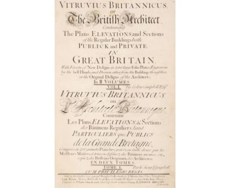
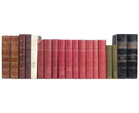
Lot 355
Campbell (Colin). Vitruvius Britannicus, or the British Architect, Containing the Plans, Elevations, and Sections of the Regular Buildings both Publick and Private in Great Britain, volumes I & II, 1st edition, London: For the author, 1715-1717, subscribers list in volume I, 160 engraved plates, numbered to 200 including titles and dedication (complete), some double-page and folding, a few plates with repaired tears and reinforcements to verso, light toning to one or two plates, occasional light spotting, previous owner inscription of William Smith, Durham University, 1938, contemporary panelled calf gilt, spines rubbed with small splits and some worming, some edge wear, folio 44.5 x 27 cm QTY: (2)NOTE:Fowler 76; Harris 9; Millard 10. First edition of the first two volumes of the Palladian revival which set the pattern for English architectural design in the eighteenth century. Volume III was published in 1725 followed by volumes IV (1767) and V (1771).Provenance: Sir William Whitfield CBE (1920-2019), one of the most significant British architects of the second half of the 20th century, notable for his ground-breaking designs for major public projects including Glasgow University Library, the Hunterian Art Gallery (1960-1968), Richmond House in Whitehall (1982-1984), recently selected as one of London’s ten most iconic Postmodern Buildings, Hereford Cathedral’s Mappa Mundi Library (1996), and Hawksmoor’s Baroque masterpiece Christ Church Spitalfields, slowly and carefully restored over three decades from 1970 to 2000 under his direction. He was Surveyor of the Fabric of St Paul’s Cathedral between 1985 and 1990.
Lot 357
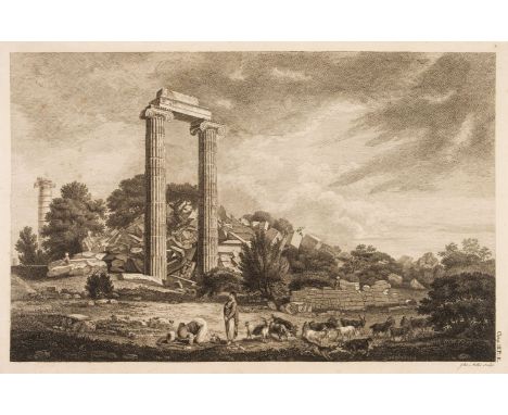
Chandler (Richard, Nicholas Revett & William Pars). Ionian Antiquities, published with permission of the Society of Dilettanti, volume I only (of 5), 1st edition, London: T. Spilsbury and W. Haskell, 1769, double-page engraved frontispiece of inscriptions, 28 full-page engraved plates and plans, engraved head and-tail pieces, occasional minor spotting contemporary previous owner signature of John Power to front endpaper verso, contemporary diced half calf, gilt-decorated spine, a little rubbed with some edge wear, folio 54.5 x 37 cmQTY: (1)NOTE:Provenance: Sir William Whitfield CBE (1920-2019), one of the most significant British architects of the second half of the 20th century, notable for his ground-breaking designs for major public projects including Glasgow University Library, the Hunterian Art Gallery (1960-1968), Richmond House in Whitehall (1982-1984), recently selected as one of London’s ten most iconic Postmodern Buildings, Hereford Cathedral’s Mappa Mundi Library (1996), and Hawksmoor’s Baroque masterpiece Christ Church Spitalfields, slowly and carefully restored over three decades from 1970 to 2000 under his direction. He was Surveyor of the Fabric of St Paul’s Cathedral between 1985 and 1990.Blackmer 1566; RIBA 3123. First edition, first issue of volume I without chapter IV, which contains a further five plates. The full work extended to five volumes, the last of which was published almost a century and a half later in 1915.
Lot 358
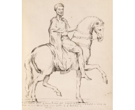
Creed (Cary). The Marble Antiquities, The Right Hon. the Earl of Pembroke... I have Drawn and Etch'd in Imitation of Perrier... They may be had of me Cary Creed at the Jarr between Cecil and Salisbury Streets in the Strand... Anno 1731, etched title, 60 etched plates only (of 70), small pale damp stain to last few plates, front endpaper detached, contemporary mottled calf gilt, upper cover detached, lower joint cracked, a little rubbed, 4toQTY: (1)NOTE:Provenance: Sir William Whitfield CBE (1920-2019), one of the most significant British architects of the second half of the 20th century, notable for his ground-breaking designs for major public projects including Glasgow University Library, the Hunterian Art Gallery (1960-1968), Richmond House in Whitehall (1982-1984), recently selected as one of London’s ten most iconic Postmodern Buildings, Hereford Cathedral’s Mappa Mundi Library (1996), and Hawksmoor’s Baroque masterpiece Christ Church Spitalfields, slowly and carefully restored over three decades from 1970 to 2000 under his direction. He was Surveyor of the Fabric of St Paul’s Cathedral between 1985 and 1990.Blackmer 426 (for the fourth edition). Rare. The third edition. "The first edition, with b16 plates, and the second, with 40, appeared in 1730. The third edition, with 70 plates, appeared in 1731. The fourth edition, with 74 plates, appeared later the same year. Creed is known mainly as the engraver of these plates. This is the first description of the Wilton House Collection. In 1751 appeared Cowdrie's Description. The next illustrated edition was that of Kennedy in 1769, with plates by J.A. Gresse." (Blackmer).
![[Fauchet, Claude, Sébastien-Roch-Nicolas de Chamfort, Pierre Louis Guingené, & Francois-Xavier Barges de Vixouse]. Collection](https://cdn.globalauctionplatform.com/2387bab2-4269-4067-987a-af3a01109e57/d413b955-db15-4d2d-a09d-af4000b127af/468x382.jpg)
Lot 359
[Fauchet, Claude, Sébastien-Roch-Nicolas de Chamfort, Pierre Louis Guingené, & Francois-Xavier Barges de Vixouse]. Collection Complète des Tableaux Historiques de la Révolution Française, 3 volumes, Paris: Chez Auber, éditeur, De l'Imprimerie de Pierre Didot l'Ainé, 1802, fine engraved plates, including portraits and battle scenes, by Duplessi-Bertaux, Girardot, Varbault and others, all edges gilt, contemporary uniform gilt-decorated full calf, rubbed and some marks, covers mostly detached, folioQTY: (3)NOTES:Provenance: Sir William Whitfield CBE (1920-2019), one of the most significant British architects of the second half of the 20th century, notable for his ground-breaking designs for major public projects including Glasgow University Library, the Hunterian Art Gallery (1960-1968), Richmond House in Whitehall (1982-1984), recently selected as one of London’s ten most iconic Postmodern Buildings, Hereford Cathedral’s Mappa Mundi Library (1996), and Hawksmoor’s Baroque masterpiece Christ Church Spitalfields, slowly and carefully restored over three decades from 1970 to 2000 under his direction. He was Surveyor of the Fabric of St Paul’s Cathedral between 1985 and 1990.
![Fonthill Library. Johann Friedrich Ludwig Hausmann, Reise durch Skandinavien in den jahren 1806 und 1807, 4 volumes [of 5], G](https://cdn.globalauctionplatform.com/2387bab2-4269-4067-987a-af3a01109e57/74d2236e-5a80-4282-8866-af4000b1286b/468x382.jpg)
Lot 360
Fonthill Library. Johann Friedrich Ludwig Hausmann, Reise durch Skandinavien in den jahren 1806 und 1807, 4 volumes [of 5], Gottingen: J.F. Röwer1812-1818, vignette titles, 14 engraved plates to rear of volumes (some folding), bookplate of D. A. Holdsworth and early inscription noting Fonthill provenance to front pastedowns, top edge gilt, remainder untrimmed, contemporary crimson red boards specially bound for the Fonthill library, gilt decorated motifs to spine compartments, green morocco labels lettered in gilt, worn, volumes 1 & 2 with loss at head of spines, rear board of volume 2 and front board of volume 3 detached, 8vo QTY: (4)NOTE:Provenance: Sir William Whitfield CBE (1920-2019), one of the most significant British architects of the second half of the 20th century, notable for his ground-breaking designs for major public projects including Glasgow University Library, the Hunterian Art Gallery (1960-1968), Richmond House in Whitehall (1982-1984), recently selected as one of London’s ten most iconic Postmodern Buildings, Hereford Cathedral’s Mappa Mundi Library (1996), and Hawksmoor’s Baroque masterpiece Christ Church Spitalfields, slowly and carefully restored over three decades from 1970 to 2000 under his direction. He was Surveyor of the Fabric of St Paul’s Cathedral between 1985 and 1990.William Beckford's copy, from Fonthill library in an iconic Fonthill binding.Fonthill Abbey, built at the request of Beckford, contained one of the finest libraries ever assembled by an individual. After the collapse of the Abbey due to erratic construction, the library was sold in 1823 after John Farquhar bought much of its contents in the preceding year. The sale attracted huge attention, with 72,000 copies of the auction catalogue sold at a guinea apiece and an average of 600 to 700 people arriving each day to view, including the Duke of Wellington. William Hazlitt described it as “a desert of magnificence, a glittering waste of laborious idleness, a cathedral turned into a toy shop”. The sale lasted 37 days.
Lot 362
Jones (Inigo). The Designs of Inigo Jones, Consisting of Plans and Elevations for Publick and Private Buildings. Published by William Kent with some additional designs, 2 volumes in one, 1st edition, 1727, engraved allegorical frontispiece by William Kent, titles with engraved vignette portrait of Inigo Jones, engraved dedication to the King, subscribers list, 97 engraved plates (plates numbered to 136) including 29 double-page and folding by Foudrinier, Hulsbergh and Cole after designs credited to Jones, William Kent and Lord Burlington, bound without the half title, frontispiece reinforced at gutter to verso, a few small marginal repairs, signature E in first volume detached, occasional light spotting, contemporary half morocco over reverse calf, discoloured with some worming and stains to covers, folio, 45 x 34 cm QTY: (1)NOTE:Provenance: Sir William Whitfield CBE (1920-2019), one of the most significant British architects of the second half of the 20th century, notable for his ground-breaking designs for major public projects including Glasgow University Library, the Hunterian Art Gallery (1960-1968), Richmond House in Whitehall (1982-1984), recently selected as one of London’s ten most iconic Postmodern Buildings, Hereford Cathedral’s Mappa Mundi Library (1996), and Hawksmoor’s Baroque masterpiece Christ Church Spitalfields, slowly and carefully restored over three decades from 1970 to 2000 under his direction. He was Surveyor of the Fabric of St Paul’s Cathedral between 1985 and 1990.Archer 166.1; Fowler 162; Harris 385. "The Designs of Inigo Jones is an impressive and important work. Yet oddly enough more influential than any single building depicted in it were its plates of doors, windows, niches, etc. These plates seem to have had a formative effect upon Gibbs's Book of Architecture (1728) and from that point on became a standard feature of eighteenth-century pattern books." (Harris).
Lot 366
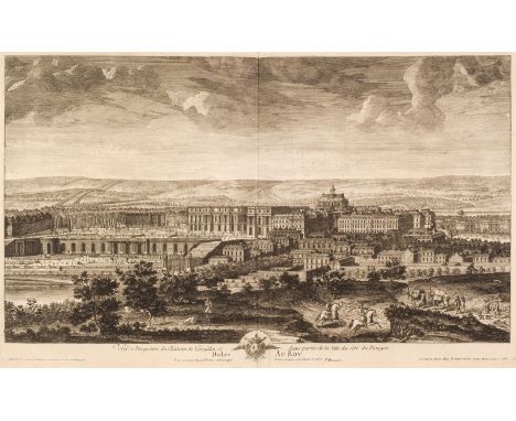
Demortain (Gilles). Les Plans, Profils et Elevations des Ville, et Chateau de Versailles, avec les Bosquets, et Fontaines, tels quils sont a present, levez sur les lieux, dessinez et gravez en 1714 et 1715... Paris: Demortain, [1716], engraved title, 32 engraved plates on 31 sheets only (of 54), including 19 double-page plates by Fonbonne, Lucas, de Rochefort and others after Delamonce, Menant, Martin and others, a few with closed tears and repairs, a few small stains, occasional pale marginal water stains, all edges gilt, contemporary red morocco gilt, some wear at spine ends and corners, folio 50 x 35.5 cm QTY: (1)NOTE:Provenance: Sir William Whitfield CBE (1920-2019), one of the most significant British architects of the second half of the 20th century, notable for his ground-breaking designs for major public projects including Glasgow University Library, the Hunterian Art Gallery (1960-1968), Richmond House in Whitehall (1982-1984), recently selected as one of London’s ten most iconic Postmodern Buildings, Hereford Cathedral’s Mappa Mundi Library (1996), and Hawksmoor’s Baroque masterpiece Christ Church Spitalfields, slowly and carefully restored over three decades from 1970 to 2000 under his direction. He was Surveyor of the Fabric of St Paul’s Cathedral between 1985 and 1990.Sold as a collection of plates not subject to return.
Lot 367
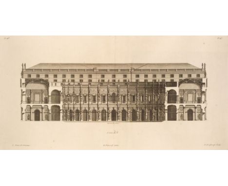
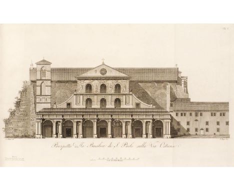
Nicolai (Nicola Maria). Della Basilica di S. Paolo, 1st edition, Rome: Nella Stamperia de Romanis, 1815, title with engraved vignette, 18 engraved plates and plans by Ruga, Mochetti & Giangiacomo, many folding, occasional light spotting, bookplate of Robert Mackenzie Beverley (1798-1868, author, polemicist and opponent of Darwin's Theory of Evolution), contemporary half vellum, small abrasions and indentations to covers, folio 45.5 x 30.5 cmQTY: (1)NOTE:Provenance: Sir William Whitfield CBE (1920-2019), one of the most significant British architects of the second half of the 20th century, notable for his ground-breaking designs for major public projects including Glasgow University Library, the Hunterian Art Gallery (1960-1968), Richmond House in Whitehall (1982-1984), recently selected as one of London’s ten most iconic Postmodern Buildings, Hereford Cathedral’s Mappa Mundi Library (1996), and Hawksmoor’s Baroque masterpiece Christ Church Spitalfields, slowly and carefully restored over three decades from 1970 to 2000 under his direction. He was Surveyor of the Fabric of St Paul’s Cathedral between 1985 and 1990.Rare work on the Basilica of Saint Paul Outside the Walls in Rome, no copies recorded at auction. Seven institutional copies located.
Lot 368
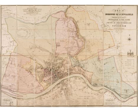
Oliver (Thomas). Plan of the Borough of Newcastle comprising the town and county of Newcastle upon Tyne and part of the County of Northumberland, together with Gateshead from an actual survey by Thomas Oliver, Architect & Surveyor, Newcastle, Thomas Oliver, 1844, engraved plan of Newcastle by W. H. Lizars after Thomas Oliver, with original hand-colouring, sectionalised on linen, with key to the public buildings, overall size 880 x 1190 mm, together with the accompanying descriptive text entitled Reference to a Plan of the borough of Newcastle upon Tyne, also dated 1844, viii+104pp., original printed wrappers, some marks and light soiling, upper outer corner of rear wrapper lacking, all contained in original publisher's plum morocco slipcase, rubbed and some marks, some wear to spine (restrengthened with clear adhesive tape), ties partly defective, 8vo QTY: (1)NOTES:Provenance: Sir William Whitfield CBE (1920-2019), one of the most significant British architects of the second half of the 20th century, notable for his ground-breaking designs for major public projects including Glasgow University Library, the Hunterian Art Gallery (1960-1968), Richmond House in Whitehall (1982-1984), recently selected as one of London’s ten most iconic Postmodern Buildings, Hereford Cathedral’s Mappa Mundi Library (1996), and Hawksmoor’s Baroque masterpiece Christ Church Spitalfields, slowly and carefully restored over three decades from 1970 to 2000 under his direction. He was Surveyor of the Fabric of St Paul’s Cathedral between 1985 and 1990.
![Palladio (Andrea). I Quattro Libri dell'Architettura [edited by Silla Palladio], 2nd edition, Venice: Battolomco Carampello,](https://cdn.globalauctionplatform.com/2387bab2-4269-4067-987a-af3a01109e57/104fd0a6-a4d4-474d-841b-af4000b12f6f/468x382.jpg)
Lot 369
Palladio (Andrea). I Quattro Libri dell'Architettura [edited by Silla Palladio], 2nd edition, Venice: Battolomco Carampello, 1581, 4 parts in one volume, titles within elaborate architectural woodcut borders, with printer's devices of 'Regina Virtus' at head and Venus in a boat with the Queen below title cartouche, 221 woodcut plans and illustrations, many full-page, blanks 2K4 & 4R4 present, occasional light spotting and toning, a few mainly marginal water stains, lacking front endpapers, small areas of worming to rear endpaper and pastedowns, contemporary limp vellum, tear and small loss to spine, a few stains, folio 33.5 x 23 cm QTY: (1)NOTE:Provenance: Sir William Whitfield CBE (1920-2019), one of the most significant British architects of the second half of the 20th century, notable for his ground-breaking designs for major public projects including Glasgow University Library, the Hunterian Art Gallery (1960-1968), Richmond House in Whitehall (1982-1984), recently selected as one of London’s ten most iconic Postmodern Buildings, Hereford Cathedral’s Mappa Mundi Library (1996), and Hawksmoor’s Baroque masterpiece Christ Church Spitalfields, slowly and carefully restored over three decades from 1970 to 2000 under his direction. He was Surveyor of the Fabric of St Paul’s Cathedral between 1985 and 1990.Adams P101; Cicognara 595; Fowler 213; Millard IV 66; PMM 92 (for the 1570 first edition); RIBA 2384. Second edition of "the most studied of the architectural treatises of the Renaissance" (Millard), first published in 1570 in Venice by Domenico de Franceschi, with new typesetting and initials but with the titles and illustrations printed from the original plates, and edited by Andrea Palladio's son Silla."Palladio's lasting influence on architectural style in many parts of the world was exercised less through his actual buildings than through.his textbook. This is divided into four sections: orders and elementary problems, domestic buildings, public building and town planning and temples. Palladio's style was directly inspired by Roman classical models through the writings of Vitruvius and Alberti. Its characteristics are those of classicism: symmetry, order, fixed mathematical relations of the parts to each other and to the whole, logic and monumentality. Though it is true that Palladio in his later period adopted some of the mannerist vernacular, his buildings remain essentially classical, in contrast to the baroque style of the period in Rome and Piedmont." (PMM).
Lot 370
Palladio (Andrea). The Architecture of A. Palladio; in four books. Containing, a short treatise of the five orders, and the most necessary observations concerning all sorts of building, as also the different construction of private and publick houses, high-ways, bridges, market-places, xystes, and temples, with their plans, sections, and uprights. To which are added several notes and observations made by Inigo Jones, never printed before. Revis'd, design'd, and publish'd by Giacomo Leoni, a Venetian; Architect to his most Serene Highness, the Elector Palatine, volumes 1 & 3 only (of 4), London: Printed by John Watts, for the Author, 1715 - [1718], engraved portrait of Palladio by V. Picart after Veronese [actually a portrait of an unknown man by Sir Sebastiano Ricci], an additional engraved allegorical frontispiece by B. Picart after Sebastiano Ricci, printed title, translator's preface by Nicholas du Bois, subscriber's list, Preface to the Reader [translated from Palladio], and 43 engraved plates, of which 31 are full-page, and with Italian and French versions of the text at end, each with separate title page, contemporay blind-decorated full calf, gilt decorated spine, rubbed and scuffed with some wear to joints and edges, joints partly cracked, volume III: printed title, dedication leaf in Italian, single-leaf list of subscribers, Preface to the Reader, 20 full-page engarved plates, including one double-page, and Itlaian and French versions of the text at rear, each with seperate title page, I2 with small paper repair to lower blank inner margin, contemporary dark brown full calf, rubbed and scuff with a little wear to extremities, both large folio QTY: (2)NOTE:Provenance: Sir William Whitfield CBE (1920-2019), one of the most significant British architects of the second half of the 20th century, notable for his ground-breaking designs for major public projects including Glasgow University Library, the Hunterian Art Gallery (1960-1968), Richmond House in Whitehall (1982-1984), recently selected as one of London’s ten most iconic Postmodern Buildings, Hereford Cathedral’s Mappa Mundi Library (1996), and Hawksmoor’s Baroque masterpiece Christ Church Spitalfields, slowly and carefully restored over three decades from 1970 to 2000 under his direction. He was Surveyor of the Fabric of St Paul’s Cathedral between 1985 and 1990.ESTC T95463; Fowler 223; Harris 683; RIVA, early printed books, 2391.'This edition marks a turning point in the history of British Palladianism, being not only the first complete English translation of I Quattro Libri but also the first edition to contain worthwhile engraved copies of the original woodcuts (several earlier editions have contained crude or incomplete copies)'. (RIBA). The list of subscribers number 308, indicating a low print run. The notes and observations of Inigo Jones, refer to in the title were only published for the first time in the 3rd edition of 1742.
![[Pearson, John and others, editor]. Critici Sacri: sive clarissimorum virorum in sacro-sancta utriusque foederis Biblia, doct](https://cdn.globalauctionplatform.com/2387bab2-4269-4067-987a-af3a01109e57/fe659cc7-ecd1-4467-9690-af4000b1311c/468x382.jpg)
Lot 371
[Pearson, John and others, editor]. Critici Sacri: sive clarissimorum virorum in sacro-sancta utriusque foederis Biblia, doctisssimae annotationes atque tractatus theologico-philologici. Opus summa cura denuo recognitum... e IX in VII tomos redactum, 7 volumes, 2nd edition, Frankfurt: Balthasaris Christophori Wustii for Johannis Philippi & Johannis Nicolai Andreae, 1695-96, volumes II, III, V & VII dated 1695, the others 1696, volume I with half title and title printed in red and black, text printed in double column, 13 engraved maps and plates, including 7 folding in volume VI, woodcut illustrations, occasional light toning and spotting, previous owner inscription dated 1911 to volume I front endpaper, all edges blue, contemporary uniform vellum, spines titles and numbered in neat manuscript, some light dust-soling and a few minor stains, folio (25.5 x 20.5 cm)QTY: (7)NOTE:Provenance: Sir William Whitfield CBE (1920-2019), one of the most significant British architects of the second half of the 20th century, notable for his ground-breaking designs for major public projects including Glasgow University Library, the Hunterian Art Gallery (1960-1968), Richmond House in Whitehall (1982-1984), recently selected as one of London’s ten most iconic Postmodern Buildings, Hereford Cathedral’s Mappa Mundi Library (1996), and Hawksmoor’s Baroque masterpiece Christ Church Spitalfields, slowly and carefully restored over three decades from 1970 to 2000 under his direction. He was Surveyor of the Fabric of St Paul’s Cathedral between 1985 and 1990.First published in 1660, and edited by John Pearson (1613-1686), theologian and classical scholar, who was appointed Master of Trinity College, Cambridge, in 1662, and bishop of Chester in 1672. Intended as a companion work to Brian Walton's famous Polyglot Bible of 1655-57. A two-volume supplement, not present here, was added in 1701.
Lot 372
Piranesi (Giovanni Battista). Varie Vedute di Roma Antica, e Moderna. Disegnate e Intagliate da Celebri Autori, Roma: Fausto Amidei, 1748 [but 1750 or later], 87 etched plates, including title only (of 94), of which 45 (of 48) signed Piranesi, others by P. Anesi, Bellicard, Duflos et al, some identified in manuscript to lower margin (a few inscriptions cropped at outer margin), 3 plates with a water stain just touching image, a few others with small marginal damp stain, occasional light marginal dust-soiling, previous owner initials to right-hand margin of title, bookplate of George Thomas Whitgreave (1787-1863), contemporary wrappers, later backstrip, a little rubbed, oblong folio, sheet size 29.5 x 23 cmQTY: (1)NOTE:Provenance: Sir William Whitfield CBE (1920-2019), one of the most significant British architects of the second half of the 20th century, notable for his ground-breaking designs for major public projects including Glasgow University Library, the Hunterian Art Gallery (1960-1968), Richmond House in Whitehall (1982-1984), recently selected as one of London’s ten most iconic Postmodern Buildings, Hereford Cathedral’s Mappa Mundi Library (1996), and Hawksmoor’s Baroque masterpiece Christ Church Spitalfields, slowly and carefully restored over three decades from 1970 to 2000 under his direction. He was Surveyor of the Fabric of St Paul’s Cathedral between 1985 and 1990.The views by Piranesi are among his earliest topographical engravings.
Lot 373
Poley (Arthur F.E.) St. Paul's Cathedral London, 2nd edition, London: printed for the author, 1932, collotype frontispiece, title printed in red and black with two medallions, 32 plates, original half morocco by Zaehnsdorf, one or two edges slightly rubbed, worn slipcase, folio 56.5 x 38 cmQTY: (1)NOTES: Provenance: Sir William Whitfield CBE (1920-2019), one of the most significant British architects of the second half of the 20th century, notable for his ground-breaking designs for major public projects including Glasgow University Library, the Hunterian Art Gallery (1960-1968), Richmond House in Whitehall (1982-1984), recently selected as one of London’s ten most iconic Postmodern Buildings, Hereford Cathedral’s Mappa Mundi Library (1996), and Hawksmoor’s Baroque masterpiece Christ Church Spitalfields, slowly and carefully restored over three decades from 1970 to 2000 under his direction. He was Surveyor of the Fabric of St Paul’s Cathedral between 1985 and 1990.
Lot 374
Porcacchi (Thomaso). Funerali Antichi di diuersi Popoli, et Nationi; forma, ordine, et pompa di sepolture, di consecrationi antiche et d'altro, Venice: [Appresso Simon Galignani de Karera], 1574, engraved title with architectural border, 23 engraved plates within text, woodcut initials, head and tailpieces, final leaf with printer's device, armorial bookplate of George Wilbraham to front pastedown, K4 and final leaf with obtrusive notations, final 3 leaves damp-stained (affecting text), K3 with small marginal repair, scattered spotting and dust-soiling, hinges tender, 18th-century half calf over marbled boards, rubbed, 4toQTY: (1)NOTE:Provenance: Sir William Whitfield CBE (1920-2019), one of the most significant British architects of the second half of the 20th century, notable for his ground-breaking designs for major public projects including Glasgow University Library, the Hunterian Art Gallery (1960-1968), Richmond House in Whitehall (1982-1984), recently selected as one of London’s ten most iconic Postmodern Buildings, Hereford Cathedral’s Mappa Mundi Library (1996), and Hawksmoor’s Baroque masterpiece Christ Church Spitalfields, slowly and carefully restored over three decades from 1970 to 2000 under his direction. He was Surveyor of the Fabric of St Paul’s Cathedral between 1985 and 1990.Adams P1903; Mortimer 395; Lipperheide 101. First edition.
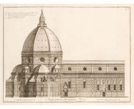
Lot 377
Sgrilli (Bernardo Sansone). Descrizione e Studj dell' Insigne Fabrica di S. Maria del Fiore Metropolitana Fiorentine, 1st edition, Florence: Bernardo Paperini, 1733, engraved portrait frontispiece of Giovanni Battista Nelli by Vin. Franceschini, title printed in red and black with engraved vignette, 17 folding engraved plates and plans by Sgrilli after Nelli, engraved head and-tail pieces and initials, some plates with small repairs and reinforcements to verso, small water stain to gutter, a few minor stains, repairs to pastedowns, contemporary half morocco, manuscript title to spine, later printed label to upper cover, a few small wormholes, discolouration and light edge wear, folio, 47.5 x 32.5 cm QTY: (1)NOTE:Provenance: Sir William Whitfield CBE (1920-2019), one of the most significant British architects of the second half of the 20th century, notable for his ground-breaking designs for major public projects including Glasgow University Library, the Hunterian Art Gallery (1960-1968), Richmond House in Whitehall (1982-1984), recently selected as one of London’s ten most iconic Postmodern Buildings, Hereford Cathedral’s Mappa Mundi Library (1996), and Hawksmoor’s Baroque masterpiece Christ Church Spitalfields, slowly and carefully restored over three decades from 1970 to 2000 under his direction. He was Surveyor of the Fabric of St Paul’s Cathedral between 1985 and 1990.Berlin Kat 2694; Cicognara 4096. Important work on the architecture and plans of the complex of Florence Cathedral.
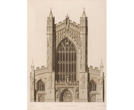
Lot 378
Society of Antiquaries of London. Some account of the collegiate chapel of Saint Stephen, Westminster, by John Topham, [plans, etc. by John Carter; additional plates and descriptions by Sir H.C.Englefield], [London: Society of Antiquaries, 1795], 28 engraved plates & plans including additional engraved title (2 plates double-page & one folding, additional title creased), bound with Some account of the Abbey Church of Bath..., [London: Society of Antiquaries, 1798], 10 engraved plates & plans including additional engraved title, bound with Some account of the Cathedral Church of Exeter..., [London: Society of Antiquaries, 1797], 11 engraved plates & plans including additional title (3 plates double-page), tissue guards to each plate throughout volume, occasional scattered spotting, contemporary half calf, boards detached and some wear, large folio (65 x 48 cm), together with:Society of Antiquaries of London, Some account of the Abbey Church of St Alban, [by Richard Gough, with the assistance of James Brown and John Nichol], illustrative of the plans, elevations, and sections of that building, [drawn by John Carter]; [edited by Sir H.C. Englefield], London: Nichols & Son, 1813, 19 engraved plates & plans, edges untrimmed, sewing partly broken, contemporary half sheep, upper board detached, lacking spine, worn, large folio (68 x 50 cm), Britton (John), Chronological History and Graphic Illustrations of Christian Architecture in England..., London: Longman, Rees, Orme, Brown & Green, 1826, additional etched title, numerous etched & engraved plates and plans, all edges gilt, contemporary gilt decorated burgundy straight grain morocco, spine torn at head, extremities rubbed and scuffed, 4to, plus Newcome (Peter), The History of the Ancient and Royal Foundation, called the Abbey of St. Alban, in the county of Hertford..., London: Printed for the author by J. Nichols, 1795, engraved frontispiece and two folding plans, lacking folding map, some toning and scattered spotting, 19th century half calf, upper joint cracked and lower board detached, extremities rubbed, 4toQTY: (4)NOTES:Provenance: Sir William Whitfield CBE (1920-2019), one of the most significant British architects of the second half of the 20th century, notable for his ground-breaking designs for major public projects including Glasgow University Library, the Hunterian Art Gallery (1960-1968), Richmond House in Whitehall (1982-1984), recently selected as one of London’s ten most iconic Postmodern Buildings, Hereford Cathedral’s Mappa Mundi Library (1996), and Hawksmoor’s Baroque masterpiece Christ Church Spitalfields, slowly and carefully restored over three decades from 1970 to 2000 under his direction. He was Surveyor of the Fabric of St Paul’s Cathedral between 1985 and 1990.
-
1532 item(s)/page