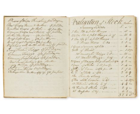
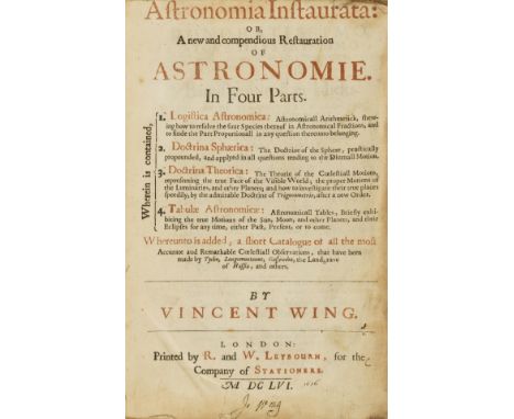
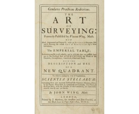
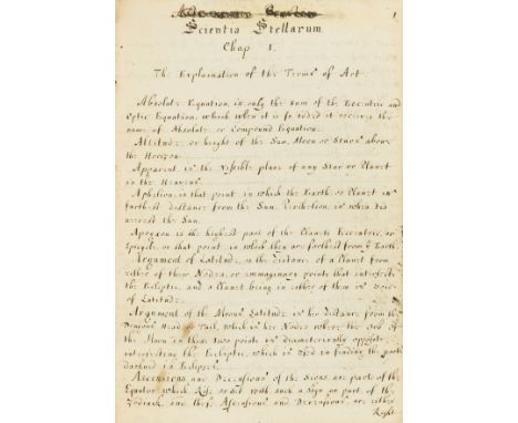
Astronomy.- Wing (John, surveyor and almanac maker, of Pickworth, Rutland, nephew of Vincent Wing, astronomer, astrologer, and land surveyor, 1619-68, bap. 1662, d. 1726) Astronomia Nova Britannica, or The New British Astronomy Containing an Exact Theorie of the Coelestial Motions, according to the Genuine and most Rational Systems of the World, wherein the Sun is Centre of the Planetary Orbs... Deduced from Astronomia Britannica Published in Latine by Mr V. Wing..., manuscript, title and 163pp. (pp. 1-30 mostly text, pp. 30-160 mostly tables), a few ink diagrams, pp. 74-75 glued together and a corrective slip glued over p. 102, several ff. loose, a few small tears to edges, browned, contemporary panelled calf, extensively rubbed, lacks tail of spine, sm. 4to, dated in another hand at end 1691, but probably late 1680s, see ODNB note below, [c. 1688].⁂ A unique copy of an unpublished 17 century astronomical treatise."At the end of the 1680s, [George Parker, a rival astrologer] alleged, [John] Wing had tried to rush into print a manuscript entitled 'Astronomia nova Britannica', which he had been forced to abandon when Henry Coley exposed it as only half completed. Wing had then reworked the manuscript as Scientia stellarum, which he had published despite John Flamsteed's warning that it was itself full of crude errors. Wing issued a pained rebuttal of all these charges in his almanac for 1704, pointing out that his project was essentially an English summary of his uncle's Astronomia Britannica, and claiming that Flamsteed, on whose astronomical observations it drew, had commended it." - Oxford DNB.Vincent Wing, "taught himself arithmetic, surveying, and dialling by the age of twenty, mastered Latin, and acquired a competence in Greek. He spent the rest of his life practising as a surveyor and diallist in the east midlands... . Wing's fame rested primarily on his achievements in astronomy, as a champion of the new astronomical systems of Copernicus and Tycho Brahe. Wing's last and most important work, Astronomia Britannica (1669), appeared shortly after his death. This was a large-scale Latin treatise on the size, distance, and motions of the planets according to the Copernican system, documented by numerous observations by Tycho Brahe, Bullialdus, Gassendus, and other continental astronomers, and by Wing himself and a group of English astronomers with midlands connections, notably Samuel Foster, John Palmer, and John Twysden. This volume, aimed at a European as well as English readership, was the most significant English astronomical work of its time and made a considerable impact both in England and on the continent." Wing's nephew, John, "was the son of Moses Wing (bap. 1629, d. 1697?), Vincent Wing's brother. He was a surveyor at North Luffenham, before moving in 1683 to Pickworth, in Rutland, near Stamford, where he practised and taught surveying and all branches of mathematics, including dialling, laying out enclosures, building plans, and music. Like his uncle before him, he also used his almanacs to popularize the new astronomy. He explained and defended Copernicanism, noting in 1690 that many people still adhered to the Ptolemaic system, and wrote brief essays on tides, gravity, the periodicity of comets, and the possibility of other solar systems and inhabited planets within the universe." - Oxford DNB. Inscription at end reads: "14th Jan 1691 at 5 h 30 P.M. qr in to Holland."


![[MANUSCRIPT - CIPHERING]. EVANS, Cadwallader. Ciphering Book of a Colonial Schoolboy. [Philadelphia], 6 April-26 July 1763. &](https://cdn.globalauctionplatform.com/972f54cb-c6fc-4bf1-9d72-adc10131c7e7/5998b82a-47f8-40a9-9e2b-adc201259bda/468x382.jpg)
![[MATAGORDA PROPRIETORS]. Partly printed document accomplished in manuscript. A land deed signed by two of the proprietors, bo](https://cdn.globalauctionplatform.com/972f54cb-c6fc-4bf1-9d72-adc10131c7e7/62b9bc2b-c9b3-4235-aaa4-adc201441a8b/468x382.jpg)