We found 1532 price guide item(s) matching your search
There are 1532 lots that match your search criteria. Subscribe now to get instant access to the full price guide service.
Click here to subscribe- List
- Grid
-
1532 item(s)/page


Lot 46
FRANCIS STONE (1769-1835, BRITISH) AND DAVID HODGSON (1798-1864, BRITISH) Norwich Castle pen, ink and watercolour, signed and dated Sept 3 1833 lower left, inscribed Figures and Landscape by D Hodgson lower right 16 ½ x 21 ½ ins Footnote: Francis Stone was an architect and surveyor for Norwich and the County of Norfolk, who practised in partnership with John Brown. He was particularly known for:The design of St Andrew’s, Norwich Mental Asylum at Thorpe, built 1811 to 1814, now redeveloped into luxury flats and housesHis Patronage of the Norwich School of Artists, in particular David Hodgson who was Secretary and Vice President to the Society and married Stone’s daughter in 1823His collaboration with Hodgson and their publication of their book, The Picturesque Views of all the Bridges belonging to the County of Norfolk 1831, which contained eighty-four lithographs of bridges, all based on detailed accurate drawings by StoneHis designs, plans, elevations and survey of Norwich Castle 1826 and amendments of 1834This Watercolour depicting one of the amended elevations of the castle presents a rare opportunity to acquire an original work by the duo.

Lot 353
South African Railways REGULATIONS AND TARIFF FOR THE HARBOURS OF THE UNION OF SOUTH AFRICA AND OF SOUTH-WEST AFRICA (Personal copy of the Surveyor Docks) 247 x 159 x 12mm (Personal copy of the Surveyor Docks with numerous footnotes and letters from the Ministry of War Transport, rubber stamps, documents, etc.) 171pp. Original cloth hardcover. Unique in that this is the original personal copy of the Surveyor Docks. Includes Dept. of Customs and Excise rubber stamp, several penned foot-notes and numerous amendment paste-downs. Also included are numerous loose documents as well as letters from the Ministry of War Transport. Faded spine, otherwise well preserved throughout. Good Pretoria South African Railways 1948

Lot 26
A Victorian silver four piece tea and coffee service and salver by Robert Harper, London 1866, the tea and coffee pots with compressed ball finials to the double domed covers, leaf-capped loop handles, embossed with vacant shields on scroll outline cartouches, drapery swags and flower and fruit bouquets, on circular bases, the tea coffee pot 29cm (11in) high, the tea pot 29cm (11in) long; the shaped circular with a cast scroll and flowers border, an engraved band of flower and fruit bouquets in panels and presentation inscribed, 52cm (20 1/2in) diameter, 6006g (193.1 oz) gross, in a fitted oak carrying case, the name plate engraved John Lakeman. The salver engraved: Presented with a tea & coffee service to Mr John Lakeman on his leaving Costislost by his warmly attached friends as a tribute of their regard and in recognition of valuable services rendered to the neighbourhood where he resided for a period of 50 years. 27th September1866. From the 1861 Census: Costislost House, 1, John Lakeman, Head, M, 62, Land Agent & Surveyor.

Lot 198
A Diagram of the State of Alabama An early state map that shows surveying progress to 1840. There is no county development, but the settlements of Mobile, Montgomery, Cahaba, St. Stephens, Demopolis, Huntsville, Tuscaloosa, and Sparta are located. Large Indian Cession lands are shown including those of the Creek, Choctaw, Chickasaw, and Cherokee. Huntsville is located in the Old Madison County. Signed in the plate, ""Surveyor`s Office, Florence Alabama 25th. January 1840. Jas. H. Weakley Surveyor General of the Public Lands in Alabama."" Engraved by W.J. Stone. Issued folding with a hint of offsetting and faint scattered foxing mostly concentrated along the folds on the map`s top half. 22.6"" W x 11.7"" H General Land Office, 1840
![[Lot of 2] Map of the State of Florida Showing the Progress of the Surveys Accompanying Annual Report of the Surveyor Genera](http://lot-images.atgmedia.com/SR/36385/2916721/224-2014116143719_468x382.jpg)
Lot 224
[Lot of 2] Map of the State of Florida Showing the Progress of the Surveys Accompanying Annual Report of the Surveyor General for 1859 [and] Florida A. Map of the State of Florida Showing the Progress of the Surveys Accompanying Annual Report of the Surveyor General for 1859, by U.S. State Surveys, from Sen: Ex: Doc. No. 2, 1st Sess., 36th Cong., dated 1859, black & white (24.1 x 23.6""). This state survey map is drawn on a scale of 18 miles to the inch. It shows the topography, vegetation, towns, cities, forts, rivers, lakes, swamps and many early trails and roads. Most of the state is shown as surveyed with a key designating the extent or the work completed. Area extends to show the keys and to Dry Tortugas Island and Ft. Jefferson, and locates Ft. Lauderdale, Boca Rabones, Key Biscayne and scores of smaller keys. It is signed in the plate by Francis L. Darcy, Surveyor General. Condition: Issued folding with several fold separations that have been mostly closed on verso with archival tape and moderate toning along the folds. B. Florida, by Morse & Gaston, circa 1856, hand color (5.0 x 6.7""). This small map of Florida was published in The Diamond Atlas. Despite being issued only a few years before the above map, surveying had only reached as far south as Tampa. Condition: Light toning with faint damp stains. See description See description 1856-59
![[Lot of 4] Plan of the Front Part of the City of New Orleans... [and] Plan of the Front Part of the City of New Orleans, in](http://lot-images.atgmedia.com/SR/36385/2916721/241-2014116143747_468x382.jpg)
Lot 241
[Lot of 4] Plan of the Front Part of the City of New Orleans... [and] Plan of the Front Part of the City of New Orleans, in 1818 [and] Plan de la Nouvelle Orleans... [and] Sketch of Part of the State of Louisiana... The first three maps are based upon the original plans by Joseph Pilie, surveyor for New Orleans, which were included in Memorial of the Mayor, Aldermen, and inhabitants of New Orleans (HR Doc. 26, 20th Congress, 1st Session). The first plan shows the entire city laid out in a grid pattern with 18 important buildings identified by a key. The second and third show the first few streets that border the Mississippi River including the custom house, water works and Market Hall. The third map also shows the improvements made to the quays and levees. The last map, which is not listed in Claussen & Friis, depicts the course of the Mississippi River from north of Nachez, Mississippi to the Gulf of Mexico. It shows the drainage network of trenches and embankments along Lake Chetimaches (Grand Lake) and Lake Ponchartraine. A. Plan de la Nouvelle Orleans, sur les Manuscrits du Depot des Cartes de la Marine, by Joseph Pilie, black & white (10.8 x 7.6"").B. Plan of the Front Part of the City of New Orleans, in 1818, by Joseph Pilie, black & white (21.9 x 7.3"").C. Plan of the Front Part of the City of New Orleans. Shewing the Additions, Alterations and Improvements Made on the Old Quays and Levees of the Said City..., by Joseph Pilie, black & white (21.9 x 7.1"").D. Sketch of Part of the State of Louisiana Accompanying a Report of the Commissioner of the Genl. Land Office of the 12th of January 1829, hand color (18.6 x 22.5""). The first three maps are in very good condition with some minor scattered foxing. The fourth map is in good condition with light to moderate toning, very faint offsetting, and a few damp stains. See description U.S. Government, 1860

Lot 256
Montana Territory This is the uncommon large edition map that shows in great detail the extent of public surveys in Montana just two years before attaining statehood in 1889. Hydrology and topography are well developed on this colorful map. The map shows Indian reservations (Blackfeet, Flathead etc.), military posts (Forts - Assiniboine, Keogh, Maginnis, Custer, Camp Baker, etc.) and the completed and proposed railroads. Also locates Custer Hill, Custer`s Monument, and the Reno battlefield; and Yellowstone National Park in its entirety with major features identified. Remarkable detail throughout on a scale of 1 inch to 15 miles. Extensive legend identifies land offices, Surveyor Generals Office, county seats, towns, villages and railroad stations, railroads (completed and proposed), military reservations, Indian reservations, railroad land grant limits, etc. A colorful example issued folding with light color offsetting and several splits along the folds at bottom mostly closed on verso with archival tape. 26"" W x 39"" H General Land Office, 1887

Lot 283
A Diagram of Public Surveys in Oregon An early land office map of Oregon that is signed in the plate by the Surveyor General in Eugene City. It features good detail on a scale of 1 inch to 18 miles and delineates the status of public land surveys in 1862. Locates roads, towns, topography by hachure, major rivers, and the routes of exploration. Delineates and names General Harney`s Cutoff, Fremont`s Trail, the Immigrant Road, Fort Boisee, Applegates Trail, Meeks Trail, and more. Survey progress is limited to the western valley and Columbia River areas. Clean and bright with attractive color. Issued folding with several small fold separations that have been archivally repaired. Binding trims at left have been replaced with old paper. 17.9"" W x 24"" H Bien, Julius 1863

Lot 349
De Cust van Westindien, Tusschen Punta St. Blaes, en Punta d Naes This rare chart focuses on the coastline between Portobelo and the Gulf of San Blas. This area was extremely important to the Spanish treasure fleets during the 16th century. The port cities of Nombre de Dios and Portobelo, established in 1510 and 1597 respectively, are shown. Two forts are situated at the entrance to the Bay of Portobelo. The chart gives detail of anchorages, soundings, rocks and shoals. Two fine compass roses orient the chart with north on the bottom and a strapwork cartouche completes the adornment. Arent Roggeveen, a land surveyor and mathematician, taught navigation for the Dutch East and West India Companies. He also helped maintain their collection of hydrographic manuscripts and charts. In the mid 1660s, Roggeveen compiled a series of large-scale sea charts of North America and the West Indies, which was published by Pieter Goos in Het Brandende Veen or The Burning Fen. This landmark atlas was the first Dutch pilot to focus on the Americas, with a number of regions mapped in larger scale than in any previously printed work. After Goos died in 1679, his widow sold the plates to Jacob Robijn, who reissued the maps with his name added to the title, as seen here. Both editions are extremely rare. Watermarked paper with a narrow top margin, as issued. 16.8"" W x 19.8"" H Roggeveen, Arent 1675

Lot 470
Cantyra Chersonesus, Cantyr a Demie-Yland This finely engraved map depicts the peninsula of Kintyre within Argyll and Bute, with north oriented to the right. The map, based on the work of Timothy Pont, famous surveyor of Scotland in the late sixteenth century, includes great detail of the rivers, villages and castles. An elaborate title cartouche and scale of miles cartouche decorate the map, both illustrated with putti. Dutch text on verso, published between 1654-62. A very bright, clean example on watermarked paper. 16.4"" W x 19.8"" H Blaeu, Johannes 1654
![[6"" Lunar Globe] La Lune This attractive steel globe depicts the surface of the moon in good detail. Several unm](http://lot-images.atgmedia.com/SR/36385/2916721/45-2014116144350_468x382.jpg)
Lot 45
[6"" Lunar Globe] La Lune This attractive steel globe depicts the surface of the moon in good detail. Several unmanned, robotic landings from both the United States and former Soviet Union are depicted included landings from the Surveyor, Ranger and Luna programs. A 60-degree wide area on the far side of the moon is left blank, as these features were unknown at the time. The globe sits on a plastic base shaped to mimic the surface of the moon. A clean and bright example. 8"" W x 5.5"" H Replogle Globes, 1966

Lot 93
Louisiana This is the first printed map to depict the topography of the Louisiana Purchase. It covers the western part of North America from Canada through most of Mexico. The map is a direct offspring of the notable map drawn a decade earlier when the Spanish Governor of Louisiana hired the services of Antoine Soulard, a surveyor from St. Louis, to make an accurate map of the upper Mississippi and Missouri basins. Wheat says it is important to remember that when Arrowsmith first published this map ""no one knew the location of the Mississippi`s source, much less where the Missouri took its rise, the extent of its major tributaries, the true nature of the Rocky Mountains or the complexities that they encompassed, not to mention the singular character of the Great Basin, or the vast extent of the Columbia and the Colorado river systems."" He continues ""it is not too much to say that, until Lewis and Clark`s own map appeared in print in 1814, the Soulard map, in the version offered to the public by Arrowsmith and Lewis in 1804, constituted the most ambitious the most informative published attempt to portray the West and Northwest of what is now the United States."" Wheat devotes over four pages of text to this ground-breaking map, which also discusses the maps deficiencies and omissions. Below the title cartouche at upper left is ""Drawn by S. Lewis"" and ""Tanner Sc."" This is one of Tanner`s earliest works and is a forerunner to many other important maps of the Transmississippi West. There is one small stain in the lower left portion of the image and a manuscript page notation in the top right blank margin. 10"" W x 8"" H Arrowsmith & Lewis, 1804

Lot 482
CHELSEA POCKET GUIDE 1925-26 Very scarce Chelsea pocket handbook style guide, season 1925-26, twenty six pages plus four cover pages. Issued "with the compliments of John Hollingsworth" Auctioneer, Surveyor and Estate Agent, Walham Green, S.W. Titled "Pocket Souvenir of Chelsea Football Club season 1925-26", the twenty six pages contain fixtures for 1925-26 First team and London Combination team. The remaining pages include ten pages devoted to a Short History of the Club and the remaining pages cover Laws of the Game and a few adverts with a frontispiece stating the name of the Club, the Ground details, Club Colours and Club Secretary-Manager. Published by S.D.P.C Limited in Tooting. The Club did not produce an official handbook for this season and neither did the Supporters Club. Condition is generally good with minor tears to spine and creases to the corner of one or two pages. Generally good

Lot 184
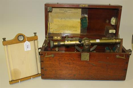
A SURVEYOR’S COMPASS LEVEL AND TRIPOD, CIRCA 1740, unsigned, 4¼in. printed compass dial with steel needle and marbled edges, contained within hinged mahogany sighting level with fixed focus, 24in. brass telescope, hinged by the eyepiece with elevation screw and mounted on tripod stand with threaded wooden legs -- 54in. (137cm.) high

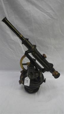
Lot 186
AN EARLY 19TH-CENTURY SURVEYOR’S COMPASS AND LEVEL BY TROUGHTON, LONDON, constructed in lacquered brass with silvered compass mounted on support bar, signed as per title with level and telescope over and threaded tripod mountings for tripod stand; together with a boxed set of six ivorine rules by Troughton & Simms, London; a proportional divider by C. Baker with government mark; a prismatic drawing instrument by Troughton & Simms in lacquered brass; a small circumferentor, probably by Stanley but unsigned; a trade catalogue for Cooke, Troughton & Simms Ltd issued 1928; and a trade catalogue for Buck & Hickman Ltd circa 1930, the level -- 6½ x 26 x 6in. (16.5 x 66 x 15cm.), (a lot)


Lot 192
A collection of assorted scientific and surveyor`s instruments and related items to include a Fuller pattern cylindrical slide rule calculator by Stanley, London numbered `4976 22`; a patinated brass marine sighting compass, probably French late19th century; a surveyor`s sight inscribed `E. R. WATTS & SON, LONDON` and fifteen other items, (18)


Lot 193
Il Paese de Cherachesi, con la Parte Occidentale della Carolina Settentrionale, e della Virgina . This map provides a detailed view of the forks of the Missouri and Ohio Rivers along the Mississippi and adjacent areas. While the map is filled with Indian villages, it shows very little European settlement other than a couple of French forts and Dr. Thomas Walker`s settlement. Dr. Walker, surveyor for the Ohio and Loyal Land Companies, led a small group into the area in 1750 and established a supply post in the area of present-day Barbourville, Kentucky. Several blocks of explanatory Italian text cross the map. This is one sheet of Zatta`s version of John Mitchell`s epic map. The whole map, titled ""Le Colonie Unite dell` America Settentrle,"" was published as a set of twelve individual maps. Each sheet stands on its own and has full borders. Original outline color on watermarked paper with moderate toning along the centerfold and a worm track near the bottom border. 16.5"" W x 13"" H . Zatta, Antonio . 1778

Lot 228
A Plat Exhibiting the State of the Surveys in the State of Florida with References . This 1855 edition shows up-to-date survey progress and development in the state. The map shows the entire state to include Key Largo and features the Forbes Purchase and the Arredondo Grant lands. Numerous forts are located including Lauderdale, Howell, Foster, Thompson, Adams, and many more. Key Biscayne is identified, but Miami is not yet named. This map was produced at the end of a period of relative peace between the U.S. and Seminole Nation. The third and final Seminole War waged between 1855 and 1858. Extensive legend gives survey status for townships. From the Surveyors Office in St. Augustine, October 1855 by John Wescott, Surveyor General. Issued folding, and now flattened and backed in archival tissue to repair several short fold separations. Very light soiling. 26.5"" W x 24.3"" H . U.S. State Surveys, 1855

Lot 261
Map of the Rail-Roads of the State of New York Prepared Under the Direction of William B. Taylor, State Engineer and Surveyor by S.H. Sweet, Deputy State Engr. & Survr. Very early map showing the Oil Region in northwestern Pennsylvania. It names numerous railroad lines along with those under construction and proposed routes. A table, Length of Rail Roads in Operation, lists numerous railroads and branches. Published by Weed, Parsons and Co., Albany, NY. A very handsome map, with decorative borders and a fine vignette of a train. Printed in blue ink. Issued folding with light toning along the folds. 29.8"" W x 24"" H . Sweet, S.H. 1865
![Esquisse du Muskinghum [on sheet with] Esquisse du Sioto [and] Esquisse de la Riviere du Grand Castor . Interesting map from](http://lot-images.atgmedia.com/SR/36385/2914150/270-201495113414_468x382.jpg)
Lot 270
Esquisse du Muskinghum [on sheet with] Esquisse du Sioto [and] Esquisse de la Riviere du Grand Castor . Interesting map from a French edition of Crevecoeur`s important early collection of essays (Letters from an American Farmer). The sheet contains three separate maps showing the Indian villages in the region of the Ohio River. Engraved by Pierre Francois Tardieu. At upper left above neatline is ""Tome IIIme. Page 413.""Crevecoeur was a French-born surveyor who settled in New York, where he produced this classic collection of twelve essays that reflected on the nature of American life, particularly its customs and manners. His description of bountiful American lands spurred many French people to immigrate to America. Howes describes Crevecoeur`s work as follows: ""Description of American life of great influence in attracting European immigration in the post-revolutionary period. As literature unexcelled by any American work of the eighteenth century."" . Faint offsetting with a short binding tear confined to thre right blank margin. Issued folding. 20.4"" W x 9.3"" H . Crevecoeur, Michel Guillaume De . 1787

Lot 281
Port de Rhode Island et Narraganset Baye Publie a la Requete du Vicomte Howe par le Chevalier des Barres... This important and scarce, Revolutionary War period chart is based on the third of Des Barres` charts of Narragansett Bay, which in turn was based on a Charles Blaskowitz manuscript ""A map of the bay of Naraganset with the islands, therein and part of the country adjacent."" This is the northern sheet of the two-sheet map. The map details the area locating Providence, Warwick, Potowoom, Bristol, Warren, Barrington, Swansea, and the extensive and tortuous waterways in the region. It locates roads, individual structures, mills, a college (Brown), hills, and even stone wall field boundaries. Soundings in the bay are noted in fathoms. The large inset map of Newport is even more detailed and displays the street layout with individual structures on each block shown. Titled ""Plan de Newport en Rhode Island "" it was taken from another Blaskowitz manuscript map: ""A plan of the town of Newport in Rhode Island..."" At the bottom the index locates and names 18 public buildings including the Touro Synagogue, which is the oldest standing synagogue in the US. The plan locates two windmills in Newport include the now famous Newport Tower. Blaskowitz conducted his surveys under the direction of Samuel Holland, Surveyor General for the Northern District of North America. While neither Des Barres nor Le Rouge attributed their geography to Blaskowitz, the following year William Faden published the surveys in his name. A nice impression on watermarked paper with a couple of insignificant spots, faint offsetting, and a printer`s crease at bottom. 27.6"" W x 19.8"" H . Le Rouge, George Louis . 1778

Lot 340
Novissima et Accuratissima Insulae Jamaicae Descriptio . This is the first state of a very rare English map showing the island divided into precincts. In 1670, Sir Thomas Modyford ordered a survey of the island, which was completed by John Man, the Surveyor General of Jamaica from 1661-71. The following year, John Seller, John Ogilby and Richard Blome each used the survey to publish maps of Jamaica. Seller`s map, which closely resembles Ogilby`s version, depicts the most prominent settlements with the landowners named in the large key at bottom. Port Royal is correctly located, and there are numerous settlements shown in the southern portion of the island. Anchorages, rocks, shoals and depth soundings are identified along the coastline. The map is handsomely embellished with a strapwork title cartouche supporting the coat of arms of Jamaica and putti holding aloft the coats of arms of Governors of the island: Doyley, Winsor, Modiford and Lynch. The large dedication cartouche is left blank, surmounted by Indians and flanked by alligators. Additional decorative elements include a man shooting a bull, a compass rose, a sea monster and a sailing ship.John Seller was a pioneering British publisher of nautical charts and one of the most important figures in the early history of British cartography. Seller`s shop, located near the Tower of London in Wapping, became a gathering place for seamen arriving with the latest news of distant places and provided Seller with information critical to his nautical chart business. In addition to sea charts he produced a vast array of cartographic material, the first to rival the large Dutch firms such as Blaeu and Jansson. Seller was appointed Royal Hydrographer by Charles II in 1671, and also served under James II and William III. Unfortunately his business was built on a shaky foundation and though he made several attempts to avoid bankruptcy, including a consortium partnership with other cartographers such as William Fisher and John Thornton, he was ultimately unsuccessful. As a result Seller`s maps are quite rare on the market . A nice impression with attractive color, light soiling, minor toning, an extraneous horizontal crease and a couple of very tiny holes. There are archivally repaired centerfold separations that enter map 1"" at top and 5.5"" at bottom. The map has been trimmed on all sides, with complete loss of the neatline and loss of the border and a small amount of the image at bottom. 21.2"" W x 16.3"" H . Seller, John . 1671

Lot 485
Osnabrugensis Episcopatus. Auctore Ioanne Gigante . This handsome map of the German province of Hanover was drawn by Joannes Gigas (Gigante) for Jodocus Hondius shortly before his death. This plate was among the 39 Hondius copper plates that were purchased by Willem Blaeu in 1629. He replaced Hondius` imprint with his own and published them as part of his first atlas. It is centered on Osnabruck at center and the large strapwork title cartouche incorporates a fine view of the city with its many steeples dominating the sky-line, attended by a finely attired surveyor. At lower right is an inset of Reckenberg. Further embellished with a coat of arms, small provincial armorials and a smaller cartouche. French text on verso. Attractive color with very light toning. 19"" W x 14.6"" H . Hondius/Blaeu, 1643

Lot 563
Natolia, quae olim Asia Minor . This handsome map of present-day Turkey includes several Aegean Islands and Cyprus prominently shown in the south. A fierce sea battle rages in the Mediterranean along with curious looking sea monsters. Two winged female creatures suspend the banner style title cartouche, and the map is further decorated with a surveyor holding an unusual vertical scale of miles. Blank verso. A nice impression on watermarked paper with minor soiling and a few creases that have been pressed flat. There is a 1"" tear off the western coast of Turkey that has been professionally repaired. 19.6"" W x 15"" H . Blaeu, (Family) . 1635

Lot 762
Message from the President of the United States to the Two Houses of Congress ... Part IV... This is the complete volume of illustrations accompanying the reports submitted for the 1st session of the 34th Congress. The 35 illustrations are primarily from the General Land Office (16) and Bureau of Topographical Engineers (13), but also include a few from the Quartermaster General and Secretary of the Navy. Of particular interest in this volume are: Map of a Part of the Territory of Washington to Accompany Report of Surveyor General (19.3 x 14.3""). This uncommon map was executed by James Tilton, Surveyor General, from the Olympia office. This is the first GLO map of Washington Territory, issued just 28 months after its creation. The map shows limited survey progress with modest detail west of the Cascades. In the east, only major rivers are shown. Several forts (Steilacom, Nisqually, Walla Walla, & Townsend) are located and Seattle is labeled Statle. Legend at upper right identifies surveyed lines, surveys under progress, townships subdivided, and proposed surveying for the 1856 & 57 season. Map Showing the Different Routes Travelled over by the Detachments of the Overland Command in the Spring of 1855 from Salt Lake City, Utah to the Bay of San Francisco (18.5 x 22""). This uncommon map accompanied the ""Report of Capt. R. Ingalls on the march of L. Col. Steptoe from Ft. Leavenworth to California"" in 1854 and 1855. Wheat states ""it is a document of first quality.. showing three important routes."" Steptoe was looking for a new and shorter route from the Great Salt Lake to the Pacific Coast. In addition to the route chosen by Steptoe, the routes of two detachments are also traced - one under Capt. Ingalls, the other by Lt. Mowry. The map extends to include all of California and part of Oregon to above the Rogue River. It stretches eastward to name G.S. Lake City, the Mormon capital of Fillmore, Cedar City and Fort Yuma on the Colorado. References: Wheat (TMW) #868; Wagner & Camp #256. Map of Public Surveys in California... (36 x 30""). This large and remarkably detailed map delineates the progress of public surveys throughout the state on a scale of 18 miles per inch. About one-third of the state, in the north and east, remains unsurveyed. Lake Tahoe is shown fairly accurately, but is still called Bigler Lake. Printed on two sheets, joined as issued. Hardbound in original embossed cloth boards with gilt titles on front cover and spine. Overall the maps are in good to very good condition in a few cases with light toning and occasional damp staining mainly along the folds. The map of California has an 8"" binding tear and one tiny area of loss at a fold intersection. The map of Florida has a 12"" binding tear. Title page is toned and damp stained. Covers are stained and rubbed. 8.8"" W x 11.9"" H . U.S. Government, 1856

Lot 178
India. Dury (Andrew), A Map of the Provinces of Delhi, Agrah, Oude and Ellahabad, Comprehending the Countries lying between Delhi and the Bengal-Provinces, surveyed by Major James Rennell, Surveyor General to the Honourable East-India Company and Published by the Order of the Court of Directors of the said Company, pub. Laurie & Whittle, 1794, engraved map with contemp. outline colouring, on four conjoined sheets, laid on later linen, overall size 1075 x 1075mm -1
Lot 186
Manuscript map. Merrier (Capt. L. R.E.), Whitchurch Parish, Oxfordshire, north of the River Thames, 1875, partially printed map with watercolour and manuscript, sectionalised and laid on linen, tipped on letter signed by the Justices from Oxfordshire and Berkshire explaining the establishement of the boundary between Oxfordshire and Berkshire, signed and dated by the surveyor to lower right, slight creasing and dust soiling, marbled endpapers, 1215 x 955mm, contained in contemp. black morocco gilt slip case. A fascinating cartographic document with its attached letter showing how Whitchurch was mapped - after agreement between the Justices of both counties - on the boundary between Berkshire and Oxfordshire. -1

Lot 565
* Wren (Sir Christopher). Synopsis Aedificiorum Publicorum Dni. Christophori Wren Equitis Aur. Architecti Regii: A Catalogue of the Churches of the City of London; Royal Palaces; Hospitals; and Publick Edifices; Built by Sr. Christopher Wren Kt. Surveyor General of the Royal-Works, during Fifty Years: viz. from 1668, to 1718, Printed for Sam. Harding in St. Martin?s Lane, Dan. Browne near Temple-Bar, & Wm. Bathoe in Church Lane near St. Martin?s Church in the Strand. [1749?], fourteen engraved plates & plans of 15 (numbered Jan-14 and dated 1723-1726, including title, elevations & plans of St. Paul?s Cathedral, The Monument, Whitehall Palace and St. Mary le Bow Steeple), bound with fourteen additional engraved plates and plans, comprising four double-page plates of Inigo Jones? Whitehall Palace by D.M. Muller, pub. 1748-1749, two single-page plates of Horse & Foot Guards at Whitehall by William Kent, engraved by J. Vardy, pub. 1752, single-page plan & three plates of St. Pauls pub. 1746-1747 (including one double-page), single-page plates of St. Stephen?s Church Walbrook & Temple Church engraved by Thomas Boydell, pub. 1750, elevation and ground plan plates of St. Giles by the architect Henry Flitcroft engraved by P. Fourdrinier with the architect?s signature ?H. Flitcroft? to verso of each, title and free endpaper detached, occasional light dust-soiling and scattered spotting, late 19th century half morocco gilt, boards detached, loss at head of spine, worn, large folio (67 x 53cm) Harris (Eileen), British Architectural Books and Writers, 1556-1765, pub. 1991, page.503. On the death of Sir Christopher Wren in 1723, his son Christopher began preparing for publication a commemorative volume entitled ?A Specimen of the Works in Architecture of Sir Christopher Wren?. By 1729 at the latest, fifteen large copper plates had been engraved, nine of which were by Henry Hulsbergh (d.1729), of which three were from drawings by Hawksmoor, the remainder by B. Cole, Simon Gribelin, Jacob Schijnvoet and Johann Vanderbank. Proposals for publishing by subscription were drawn up at a price of one guinea. However publication did not come about until after the death of Christopher , jun., in 1747 The large copper plates that were in his possession passed with the rest of his property to his younger son, Stephen, by whom they were sold. The plates were acquired by the booksellers Samuel Harding, Daniel Browne and William Bathoe, who added their imprint and printed the plates, not as originally intended as a book with a loose title-page, but as a collection of engravings, numbered Tab. 1 to 15 They were frequently split up and as a consequence complete volumes are very uncommon. The architect Henry Flitcroft (1697-1769) is credited for a number of major commissions which include St. Giles in the Fields London, Wentworth Woodhouse, Yorkshire, Wimpole Hall, Cambridgeshire, Woburn Abbey, Bedfordshire and garden temples at Stourhead, Wiltshire. He is also attributed for the design of the State gallery at Stowe, Buckinghamshire. Only one UK institutional location found of the complete suite of engravings numbered 1 to 15 (Royal Academy of Arts). This volume therefore forms an unusually near complete collection of early engravings from this work. -1 VAT is not applicable (no *)

Lot 616
Campion's Map of Collieries Iron Works, Railways and Stations in the Mineral District of South Wales. A folding forty panel map backed on linen, hand coloured, published by C.W Campion Surveyor c. Neath Glamorganshire, mounted by Letts Sons & Co Limited London, bound in decorated green cloth with marbled end papers, C. 1875. together with a late 19th century folding map on canvas relating to the London, Railway junctions (2)


Lot 6
A French mariners lacquered brass hand-held sighting compass, Doninelli, Nice, late 19th century, Of cylindrical form with top surface inset with a silvered compass engraved with the eight cardinal points within outer scale calibrated in degrees set behind bevelled glass, the cylindrical body divided into two sections with the lower section incorporating inset silver collar scale divided in degrees rotating against a vernier scale engraved to a similar collar to the lower margin of the upper section, with two sets of pierced wire sights set at ninety degrees to each other and signed Doninelli a Nice, the lower section with single sight, rotation adjustment screw to underside and tapered brass handle, diameter 8cm (3ins approx.); with an English black japanned brass sextant, H. Hughes and Son Limited, London, early 20th century, the diamond lattice-pierced six inch radius frame with pivoted arm applied with HUSUN trademark label and mounted with mirror opposing aperture for the brass vernier scale, the main scale signed H. HUGHES & SON LTD LONDON beneath number 28394, the frame fitted with fixed sighting tube opposing mirror with wooden grip handle and three feet to underside, 27.5ins (10.75ins) wide overall; and a patinated brass aneroid surveyors barometer, Stanley, London, early 20th century, with circular silvered scale calibrated in barometric inches within another calibrated in feet with vernier adjusted via knurled crown to outer track, with fine blued steel pointer and inscribed Surveying Aneroid Compensated, STANLEY, LONDON, 2023 to the recessed centre, the exterior with pivoted vernier lens and suspension loop incorporating vernier adjustment crown, diameter 8cm (3ins approx.), with original protective leather case, (3)


Lot 612
A fine quality French Sevres style gilt bronze table casket mid-19th century, believed to have been purchased at the 1851 Great Exhibition by the current vendor`s great grandfather, the rectangular casket with outset columns to the corners surmounted by turned finials, set with six Sevres style gilded and hand painted porcelain panels depicting putti in various playful poses, the shallow pagoda style cover with scroll mounts to the corners, centred with a similar oval panel, the whole with finely engraved floral and foliate decoration, set upon an integral conforming shaped and stepped plinth base with similarly engraved border, the interior lined in the original fine dark blue silk velvet, 9½ x 8in. (24 x 20.25cm.), 4¾in. (12cm.) high, complete with original key, on an ebonised and red velvet base beneath a glass dome (cracked). * The casket contains the original purchaser`s `Exhibition Admission Card 1851` in a gilt lettered morocco leather wallet with emerald green silk lining, containing two `Season Ticket of Admission to the Exhibition of the Works of Industry of All Nations 1851`, No.350 (Henry Baker) and No.4407 (in pink card - Caroline M. Baker). Henry Baker was the son of Sir Robert Baker and the architect and surveyor of St. Pancras Station and the adjoining Baker Street. See Illustration.

![Melbourne & Suburban Railway Co. £10 share 18[59] no.10523 an attractive piece with vignette of surveyor and a navvy rev](http://lot-images.atgmedia.com/PK/1141/2907593/196-2014530104412_468x382.jpg)
Lot 196
Melbourne & Suburban Railway Co. £10 share 18[59] no.10523 an attractive piece with vignette of surveyor and a navvy revealing a steam train crossing river bridge map of route below black on thick paper embossed seal bottom right good very fine. Built a line from Melbourne City centre to Richmond Burley and Hawthorn later extending to Camberwell Lilydale and Healesville by 1889. Aquired by Government controlled Victorian Railways.Subject to 20% VAT on Buyer’s Premium. For more information please view Terms and Conditions for Buyers.` `22317301`

Lot 11
Wales - Carmarthenshire 1832 ms document on 61pp folio being a copy of the survey carried out in 1832 by David Lewis^ surveyor of the Manor of Talley^ Carmarthenshire. The ms carries details back to 1633 and has observations throughout by the Office of Woods dated 1908. It carries a wealth of detail of people and places within the manor

Lot 231
Map of the State of Florida Showing the Progress of the Surveys... This state survey map is drawn on a scale of 18 miles to the inch. It shows the topography, vegetation, towns, cities, forts, rivers, lakes, swamps and many early trails and roads. Most of the state is shown as surveyed with a key designating the extent or the work completed. Area extends to show the Keys, Dry Tortugas Island and Ft. Jefferson, and locates Ft. Lauderdale, Boca Rabones, Key Biscayne and scores of smaller keys. It is signed in the plate by Francis L. Darcy, Surveyor General. Lithographed by Bien. Issued folding, now flattened, with faint toning along a few folds and attractive color. Backed in tissue to repair numerous fold separations and remargined at left. 23.1 W x 24.5 H U.S. State Surveys, 1860
![[Lot of 3] Plan de la Nouvelle Orleans, sur les Manuscrits du Depot des Cartes de la Marine [and] Plan of the Front Part of](http://lot-images.atgmedia.com/SR/36385/2906594/244-20145813127_468x382.jpg)
Lot 244
[Lot of 3] Plan de la Nouvelle Orleans, sur les Manuscrits du Depot des Cartes de la Marine [and] Plan of the Front Part of the City of New Orleans, in 1818 [and] Plan of the Front Part of the City of New Orleans... These three maps are based upon the original plans by Joseph Pilie, surveyor for New Orleans, which were included in Memorial of the Mayor, Aldermen, and inhabitants of New Orleans (HR Doc. 26, 20th Congress, 1st Session). The first plan shows the entire city laid out in a grid pattern with 18 important buildings identified by a key. The latter two show the first few streets that border the Mississippi River including the custom house, water works and Market Hall. The last map also shows the improvements made to the quays and levees. A. Plan de la Nouvelle Orleans, sur les Manuscrits du Depot des Cartes de la Marine (10.7 x 7.5""). B. Plan of the Front Part of the City of New Orleans, in 1818 (22.0 x 7.3""). C. Plan of the Front Part of the City of New Orleans, Shewing the Additions, Alterations and Improvements Made on the Old Quays and Levees of the Said City... (21.9 x 7.2""). Overall very good condition with just a few spots of foxing. U.S. Government, 1860


![[Rare Norman`s New Orleans Map], "Norman`s Plan of New Orleans & Environs", 1854, published by B.M. Norman, lit](http://lot-images.atgmedia.com/SR/1979/2904392/1013-2014411104611_468x382.jpg)
Lot 1013
[Rare Norman`s New Orleans Map], "Norman`s Plan of New Orleans & Environs", 1854, published by B.M. Norman, lithographed by G. Hayward, New York, folding pocket map, on blue-gray paper, with original hand-coloring in outline, having 86 numbered references in the lower margin showing hotels, banks, churches, schools, theaters, hospitals, markets, cotton presses, and other public buildings, publisher`s blindstamped and gilt cover preserved, sheet 15 1/4 in. x 19 7/8 in., attractively matted and framed. Note: This seminal 19th century plan of New Orleans was first issued by Norman in 1845. In the present 1854 issue, Norman has made significant updates to the plan and has removed the credit to the original draughtman Henry Moellhausen. Moellhausen was an important early surveyor and architect, particularly active in the 1840s, and was an early advocate of an underground drainage system. This plan shows the city divided into four districts and nine wards, the former shown in pink lines and the latter in green. Norman`s most famous map, "Chart of the Lower Mississippi River", designed by Marie-Adrien Persac, was published four years after this map.

-
1532 item(s)/page