Of Kent interest- 17th Century English School - Ink and watercolour on vellum - Estate Map by James Tull and description of Stile Farm, Chartham, with title "A Map and Description of a certaine Messuag and Land called Stile Farme lying in the Parish of Chartham, & a small parcell partet of with a rid pricked line in the Parish of Chartham and in the County of Kent beinge the Demeasnes of Peter Webster Gent: Surveyed the nine and twenty day of March Anno Dni 1695 by James Tull Surveyor", within a border of running leaf design which also forms a border to this plan, and with elaborately decorated scale with dividers and the date 1695 over, and decorated compass points, 18.75ins x 25.25ins, framed and glazed
We found 1532 price guide item(s) matching your search
There are 1532 lots that match your search criteria. Subscribe now to get instant access to the full price guide service.
Click here to subscribe- List
- Grid
-
1532 item(s)/page
Of Kent interest- 18th Century English School - Ink and watercolour on vellum - Estate Map by Thomas Hogben - "Measure and Map of Bobbing Court Lodge Farm in the County of Kent belonginge to Thomas Tyndale Esqr of North Cerney in Gloucestershire now in the Occupation of Mr John Boykett", within a decorative cartouche of rococo design with scrolls and flowers, and with "A Table of REFERENCES", scale with dividers over and a pictorial representation of "A View of the Court Lodge and Buildings", and elaborately decorated compass points, "Survey'd Delineated and Admeasured by Thomas Hogben 1769", 24ins x 37ins Note: Thomas Hogben (1702-1774) may be identified with the land surveyor and schoolmaster of Smarden of that name, son of Thomas Hogben (the Elder) of Ashford, surveyor (1672-1703). The younger Thomas is also known to have produced brass sundials and possibly, occasionally clocks
T W Whipp ARIBA Chartered Architect and Surveyor Scarborough - 'Plans of the Several Townships of Newby Scalby Burniston and Cloughton', dated July 1921, from old copy of John Foord's plan of c.1796, 151cm x 70cm Condition Report Click here for further images, condition, auction times & delivery costs
T W Whipp ARIBA Chartered Architect and Surveyor Scarborough - Large collection of early 20th century plans and drawings relating to 'The Garden Estates Newby', it's layout and individual house designs in two boxes Condition Report Click here for further images, condition, auction times & delivery costs
T W Whipp ARIBA Chartered Architect and Surveyor Scarborough - drawings and plans relating to proposed house and shop Columbus Ravine for messrs Dennis and Hollaway 1914 and drawings and plans relating to proposed new house, Raincliffe Avenue, Scarborough for Mr A Bell 1905 Condition Report Click here for further images, condition, auction times & delivery costs
T W Whipp ARIBA Chartered Architect and Surveyor Scarborough - drawings and plans relating to the Glen Park Estate for Mr A Wordsworth and a copy of the Scalby Hall Residential Estate auction catalogue 15th September 1919 Condition Report Click here for further images, condition, auction times & delivery costs
Watson (Charles and Pritchett James P.). Plans, Elevations, Sections and Description of the Pauper Lunatic Asylum, lately erected at Wakefield for the West-Riding of Yorkshire; to which is added a New and Enlarged Edition of Mr Samuel Tuke's Practical Hints on the Construction and Economy of Pauper Lunatic Asylums, published York, W.Alexander and others, 1819, uncoloured engraved frontispiece, letterpress title, dedication and list of subscribers, introduction and 34 pp of text, eight engraved plates of plans, marbled endpapers, hinges strengthened, near contemporary half calf with later gilt morocco label to spine, slim folio Large paper copy in very good condition. The volume was the winning entry in a competition to find a suitable design for the Wakefield lunatic asylum with probably only a small number of copies being printed. The list of subscribers includes the engineer John Rennie and the architect George Forder. This was the earliest major work of the firm Pritchett and Watson (1813 - 1831) who went on to become the leading firm of architects in Yorkshire. Pritchett worked for Earl Fitzwilliam at Wentworth as an architect and surveyor for over fifty years and it is to the Earl that this volume is dedicated. Rare. (1)
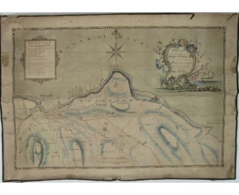
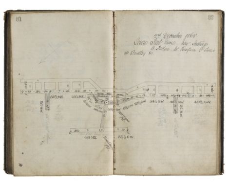
Mawe (John). The Mineralogy of Derbyshire: with a Description of the most Interesting Mines in the North of England, in Scotland, and in Wales; and an Analysis of Mr. William's Work, Intitled "The Mineral Kingdom", Subjoined is a Glossary of the Terms and Phrases used by Miners in Derbyshire, 1802, three engraved plates (including frontispiece) and single-page map, edges untrimmed, original boards, printed title label to spine, loss at head & foot of spine and some wear, 8vo, together with Sopwith (T., land & mine surveyor), An Account of the Mining Districts of Alston Moor, Weardale, and Teesdale, in Cumberland and Durham; comprising Descriptive Sketches of the Scenery, Antiquities, Geology, and Mining Operations, in the Upper Dales of the Rivers Tyne, Wear, and Tees, Alnwick: Printed by and for W. Davison, 1833, hand-coloured engraved map frontispiece (lightly offset to title), scattered spotting, original cloth, neatly rebacked preserving original printed title label, some fading to boards, 8vo, with Forster (Westgarth), A Treatise on a Section of the Strata, from Newcastle Upon Tyne, to the Mountain of Cross Fell, in Cumberland; with Remarks on Mineral Veins in General. Also, Tables of the Strata, in Yorkshire, Derbyshire, &c., To which is added, a Treatise on the Discovery, the Opening, and the Working of Lead Mines; with the Dressing and Smelting of Lead Ores, 2nd edition, greatly enlarged, Alston, Cumberland: Printed for the Author by John Pattinson, 1821, ink initial stamp to title, eleven plates (4 hand-coloured, some folding, plates 1, 2 & 11 not published), folding table, wood engraved diagrams & illustrations to text, endpapers renewed, contemporary half calf, rebacked, 8vo, plus Werner (Abraham Gottlob), New Theory of the Formation of Veins; with its Application to the Art of Working Mines..., Translated from the German, to which added, containing notes illustrative of the subject by Charles Anderson, 1st English Edition, Edinburgh: Printed at the Encyclopaedia Britannica Press for Archibald Constable & Co., 1809, half-title, lacking portrait frontispiece, edges untrimmed, original boards, repair to upper joint, wear to spine & upper joint, 8vo (4)
Wyld (Samuel). The Practical Surveyor, or, The Art of Land-Measuring Made Easy..., to which is added, an appendix added shewing how to draw buildings, &c. in perspective..., 2nd edition: corrected and enlarged by a careful hand, printed for H. Lintot, circa 1730, folding engraved frontispiece and 6 folding engraved plates, some marks and soiling, one plate restrengthened to fore-edge, contemporary calf, good-quality antique-style modern reback, together with Wilson (Henry), Surveying Improved: or, The whole art, both in theory and practice, fully demonstrated, 6th edition, with additions, two which is now added, Geodoesia Accurata... also, a new essay upon solids, by William Hume, 1769, 11 folding engraved plates, some light browning to title and margins of preliminary leaves, contemporary calf, good-quality antique-style modern reback, plus a 4th edition of the same work, 1755, 11 folding engraved plates, contemporary calf, modern antique-style reback, retaining old spine label, all 8vo (3)
Thompson (Thomas). Ocellum Promontorium, or Short Observations on the Ancient State of Holderness, 1st edition, Hull, 1821, frontispiece folding engraved map, one engraved plate and one full-page engraved illustration, cockled pages with spotting and discolouration (heavy towards rear of book), original paper wrappers (spine missing), with early ink manuscript title to front cover, stitching broken with final leaves nearly detached, 4to, together with Page (Edward), Holderness Drainage: the Report of Mr. Edward Page, upon the Better Drainage of the Lands within the Level of the Holderness Drainage, published Beverley, M. Turner, 1831, letterpress title, lacking folding map, three additional pages of contemporary manuscript notes at the end, signed by Thomas Hamer (surveyor of works of the Driffield Navigation) and on behalf of the author, followed by a handwritten statement of support signed by Thomas Hamer, page 15 with contemporary manuscript annotation to foot, marbled endpapers, sprinkled edges, contemporary half calf, 4to Ocellum Promontorium: A second volume was later published and the two are usually bound together. Extremely rare to find the first volume alone in its original paper wrappers. (2)
Kip (Jan) The South Prospect of the Cathedral Church of St. Peter in York, [c.1700], London, P. Tempest, large folio etching on laid paper, sheet 485 x 660mm, trace of folds, some closed tears [together with:] [Anon.] A plan of the City of York [c. 1740s], hand-coloured etching with inset key on laid paper, folds [&] Smith (Alfred, Surveyor) York [a plan], 1822, Leeds, E. Baines, hand-coloured engraving by Neele & Son, coat of arms and vignette of bridge, folds and false margin lower left (3).
Halifax. Des Barres (Joseph Frederick Wallet), The Harbour of Halifax, 1781, engraved chart with sparse contemporary outline colouring, old folds, one short closed tear along old fold affecting image, some spotting and staining, torn with slight loss to lower right corner, 830 x 615 mm Little is known about Des Barres. He was an army officer, military engineer, surveyor and cartographer. He arrived in North America in 1756, just seven years after the founding of Halifax. Des Barres many talents were quickly recognized by his superiors and he was soon mapping the St. Lawrence River and working on his charts in Halifax during the winter months while teaching mathematics, astronomy, and surveying to a young James Cook.In 1760 Des Barres began mapping the Halifax Harbour in preparation for the construction of fortifications and dockyards. Over the next decade he would also complete detailed hydrological surveys of the coast. The result of his endeavours was 'The Atlantic Neptune', a large collection of charts and views of the east coast of North America. It was first published in 1777. Uncommon. (1)
Typescript of a 1752 Court Case Regarding Lands in KerryCo. Kerry: Typescript (22 pp) of a case to be heard by the Irish House of Lords on 4 March 1752 between Francis Thomas, Earl of Kerry and Lixnaw, a minor, and John Petty, Viscount FitzMaurice.Thomas (FitzMaurice), 1st Earl of Kerry and Lixnaw, married in 1692 Anne Petty, daughter of the celebrated Sir William Petty, economist, scientist, philosopher and land surveyor. They had two sons: William, who succeeded his father in 1742, and John, who in 1751 inherited the estates of his maternal grandfather, changed his name to Petty, and was created Viscount FitzMaurice (he became Earl of Shelburne in 1753). William, 2nd Earl of Kerry, died in 1747 and was succeeded by his son Francis Thomas, then a young child. The law-suit is thus between a nephew and an uncle, John (the uncle) claiming money and lands under settlements made by his father the 1st Earl. In 1750 the court upheld his claim, but the nephew (through his guardian) appealed the case to the House of Lords. In this document, John demands that the original judgement be upheld.John's insistence was caused in part by the fact that under Earl Thomas's management the Kerry estate had greatly increased in value, with the construction of a mansion, deer park, gardens, fruit and forest plantations, and encouragements to tenants to improve their lands (see p. 13).An important legal document illustrating the complexities of Irish land ownership, the feuding's within a prominent family, and the development of a Kerry estate, in the first half of the 18th century, as a typescript. (1)
Rare Map of Ballycastle Colliery, 1790 Co. Antrim: Williamson (J.) Surveyor, A Map of Part of the County of Antrim Showing the particular situation of the Ballycastle Colliery, The Property of Hugh Boyd Esq., Surveyed & drawn by J. Williamson, 1790, approx. 52cms x 72cms (20 1/2" x 28 1/2") with magnificent cartouche in watercolour, & with 'Reference to the several Coal Pits,' linen backed. As a map, w.a.f. (1) * A Rare Survivor.
[Rare Atlas of New Orleans], Robinson, Elisha and Roger Pidgeon. Atlas of the City of New Orleans, Louisiana. Based upon Surveys furnished by John F. Braun, Surveyor & Architect, New Orleans, New York, E. Robinson, 1883, folio (19 1/2 in. x 15 in.), rebound in 3/4 leather, with 30 hand-colored lithographed maps, each double page (18 in. x 27 in.), featuring homes, commercial buildings, geographic landmarks, railroad and streetcar tracks; brick buildings in pink, wooden structures in yellow
By Authority LAND GRANT SIGNED BY GOVERNORS RYK TULBAGH AND SWELLENGREBEL Cape Town: Colonial Office, 1752 Land grant to Burger Dirk van der Schijf and signed by Land Surveyor P. D. Wentzel. Framed, document is age browned and foxed but all text clear and dark. On the reverse of the land grant 6 very old paper strips to reinforce the folds of the document.
*Ogilby (John). The Road from London to Aberistwith on the Sea Coast com. Cardigan. Wherein are Included the Roads to Oxford and Worcester actually Surveyed and Delineated, circa 1676, hand coloured engraved strip road map (map no.1 in the atlas), ornate cartouche showing a surveyor using a waywiser, slight creasing, small repaired hole to image, 315 x 440 mm, mounted, framed and glazed The road runs from London through Acton, Uxbridge, Beaconsfield, High Wycombe, Oxford and Islip. (1)
Staffordshire - Madeley Colliery. Three manuscript books by James Kirkwood, Mining Surveyor, containing detailed plans of Madeley Colliery, 1866-1878, together with another, circa 1890, containing plans of the Bullhurst seam that was damaged in 1883, resulting in Kirkwood's death, manuscript text and plans, a total of approximately 400 pp. including several blanks, some finger soiling throughout, contemporary roan/limp cloth, rubbed and some wear, 8vo/oblong 8vo A few years after the three manuscript books by James Kirkwood were written an explosion occurred on the evening of 21 October 1882 at the Fair Lady Pit. Due to gas a gob fire had broken out in the Bullhurst seam. Among the six victims of the accident was James Kirkwood, then aged 23 and married with one child. (4)
Robinson (John). Letter to Sir John Sinclair, Bart, from John Robinson, Esq., Surveyor-General of Woods and Forests, 5th April 1794, 1st edition, 1794, half-title, bound with Outline of the General Report on the Size of Farms, and Upon the Persons who Cultivate Farms, Drawn up for the Consideration of the Board of Agriculture and Internal Improvement, by Thomas Robinson, 1st edition, Edinburgh, 1796, half-title and final blank present, bound with General View of the Agriculture of the County of Brecknock..., by John Clark, 1st edition, 1794, half-title, bound with 7 other items from the same series including Cardigan, Carmarthen, Pembroke, East Lothian, Fife, Tweedale, and the Northern Counties and Islands of Scotland, all 1st editions, 1794 (last item 1795), some occasional spotting or marginal damp-staining and dust-soiling, contemporary paper-backed stiff blue grey wrappers, soiled and worn, 4to (1)
Lugar (Robert). Architectural Sketches for Cottages, Rural Dwellings, and Villas, in the Grecian, Gothic, and Fancy Styles, with Plans; Suitable to Persons of Genteel Life and Moderate Fortune..., new edition, London: J. Taylor, 1823, 23 hand-coloured aquatint plates (including frontispiece) and 15 engraved ground plans (complete), few leaves loose and occasional fraying to margins, lightly dudt-soiled to frontispiece & title, original cloth backed boards, covers detached from text-block, spine faded and printed title label deficient, 4to Abbey Life 30, (1805 uncoloured copy). Robert Lugar (c.1773-1855), who became County Surveyor of Essex in 1812, was a leading exponent of "Gothick" and picturesque cottages, the present work including designs for an Indian villa (inspired by Daniell's drawings), a Turkish summer house, a "fancy" cottage, and an Italian villa. (1)
John Cary. Geological Map of Oxfordshire, by W. Smith, Mineral Surveyor coloured engraving for J. Cary c.1820, 60.5 x 53cm (sheet); A map of Switzerland by N. Visscher c.1700 (stained), and An unframed map of Huntingdonshire by John Cary, 1801, 55 x 48cm (3) Geological Map of Oxfordshire is possibly a later printing though plate mark is visible.
A VICTORIAN SCOTTISH PART CANTEEN OF KING'S PATTERN (SINGLE STRUCK) FLATWARE INCLUDING:- Six table spoons, six table forks, six dessert spoons, six dessert forks, eleven tea spoons & a basting spoon, all initialled "M", maker's mark "R.S", Glasgow 1854 together with matched pair of George III Scottish table spoons with "pointed" ends, initialled "M" by A. Ziegler, Edinburgh 1794/1802; 64.3 oz (38) AUSTRALIAN INTEREST: By family repute this flatware belonged to Sir Thomas Livingston Mitchell (1792 – 1855) who took up the appointment of Assistant Surveyor General of New South Wales.
Drayton (Michael). Poly-Olbion, 2 parts bound in one, printed for M. Lownes, I. Browne, I. Helme, I. Busbie, [1612], [16]+303 pp., [8]+168+[8] pp., engraved title by William Hole, full-page engraving of Prince Henry by William Hole (titled within the image Henricus Princeps), lacking all 30 double-page engraved county maps, extensive marginal annotations and underlining in brown ink (principally to the first part), by Lewis Morris (with his signature to head of title dated 1755), extreme lower inner margin to second part with loss, not affecting text, otherwise generally in clean crisp condition, marbled endpapers with bookplate of Robert George Windsor-Clive, Earl of Plymouth to front pastedown, 19th century gilt-decorated full calf (by Toovey, Bookseller, with stamp to verso of front endpaper), rubbed to joints and extremities, with upper joint partly cracked, folio Provenance: Lewis Morris (1701-1765), Welsh surveyor, antiquary, poet and lexicographer, author of Plans of Harbours, Bays, and Roads in St. George's and the Bristol Channel (1748), Tlysau yr Hen Oesoedd (1753), Short History of the Manor of Creuthyn (1756) and Celtic Remains (1757, not published until 1878). Born in Anglesey, Morris spent most of his adult life in Cardiganshire (from 1746 as Deputy Steward of the Crown Manors in that county). One of the main promoters of the Celtic movement in the 18th century, he was regarded in both Welsh and English circles the authority on the Welsh language and its early literature and antiquities. His extensive notes to John Selden's own extensive printed notes (or 'Illustrations') provide important evidence of Morris's profound scholarship. Robert George Windsor-Clive, 1st Earl of Plymouth (1857-1923) Conservative politician, Mayor of Cardiff, and Lord Lieutenant of Glamorganshire. (1)
ROCQUE, JOHN An Exact Survey of the Cities of London and Westminster, The Borough of Southwark, with The Country near Ten Miles round; Begun in 1741, finished in 1745, and publish`d in 1746, according to Act of Parliament By John Rocque Land Surveyor; Engraved by RICHARD PARR, and Printed by W> PRATT; Sold by the Proprietor John Rocque, next the Duke of Grafton's Head, in Hyde Park Road, the Bottom of Piccadilly, and at the Print Shops in London and Westminster, Price Two Guineas in Sheets; then in Latin and French; A List of the Subscribers of This Work, Index of the Towns, Villages etc Compiled Within This Survey;Folio, bound engraved map on 16 double page sheets, emblematic group in cartouche at upper border surmounted by arms of the City of London, dedication to The Right Honourable Richard Boyle Earl of Burlington & Cork Viscount Dungarvon , a few very minor marginal nicks and tears to a couple of sheets, light variable browning and offsetting, minor water staining to lower corners sheets 7 & 8, slight damage to corners of folio cover; Rocque's famous map includes several of the new features he introduced to English cartography. The hilly ground behind the Royal Hospital [Greenwich, sheet II] ... shows to dramatic effect in his technique of hachure, while most of his land-use symbols are included -- marsh, market garden, orchard, ploughland, park and common' (Glanville). Glanville 28; Howgego 94 (2). Full set of images available upon request.
An early 19th century working estate chart, Map of the Parish of Awre in the County of Gloucester, Made partly from Old Surveys and partly from Actual Survey by Charles Baker, Land Surveyor, Civil Engineer, Architect & c., Painswick 1828, printed and laid onto canvas, the parish with plots of land numbered and annotated in ink ms., a red titled line cuts through the parish and is inscribed Forest of Dean Central Railway, including elaborate Chippendale style cartouche drawn and titled in pen and ink, printed compass to margin, the lower portion flanking the River Severn, Forest of Dean to the West, etc., 103cm x 160cm, mahogany turned baton
Attributed to Attributed to Lieutenant Robert Dale British (1810-1853) A View over the Swan River in Australia, pencil drawing, in a 19th century journal complete with entries and sketches, inscribed with title, 'Sketched by Lieut. Dale, 63rd Regt.', 'Drawn by Thurston Dale', the inscription believed to be a later addition and possibly wrong; together with a small album of loose drawings and writings, some relating to Lowesby Hall, Leicestershire, seat of F G Fowke, to include a leter from F G Fowke, September 1st 1831, a poem about Lowesby Hall by a 'Bushby', August 29th 1831 and three loose landscape drawings, with a watercolour of Snowdon and Dolbadarn Castle to the front of the album and a View of Hastings from the White Rock on the reverse, both initialled and dated "EG 1829" (2) Swan River inscribed with initials 'TD' and dated 1831 pencilCondition report: Binding worn. Typical age toning to paper. Occasional smudge marks. All edges gilt. Other Notes: Lieutenant Robert Dale (1810-1853), son of Major Thurston Dale, was a notable explorer of Western Australia, the first European to cross the Darling Range where he discovered the Avon Valley. One of the range's highest peaks, Mount Dale, as well as the Dale River were thus named in his honour. He is especially renowned for mapping the panorama of King George's Sound, of which a nine-foot-long panoramic view in aquatint was published by Robert Havell in 1834 after Dale's sketches. Having been assigned to the British Army's 63rd Regiment under the influence of his great uncle General William Dyott, Dale was posted to Western Australia in 1829. He embarked on HMS Sulphur with a detachment of troops commanded by Captain Frederick Chidley Irwin, destined to support the first settlement at Swan River. Upon his arrival, he was appointed as an assistant to the Surveyor General John S. Roe and spent four years surveying and exploring the colony. This resulted in his numerous sketches and watercolours of King George's Sound in particular, drawn from the summit of Mount Clarence. Shortly after returning to London in 1833, Dale hired Robert Havell to have his sketches made into an aquatint panorama. A copy of the panorama was notoriously exhibited at Dale's parties alongside the head of the outlawed indigenous warrior Yagan, which Dale brought back to London. The present drawing appears to be related to his best-known work, Panoramic View of King George's Sound, Part of the Colony of Swan River, copies of which notably sold at Sotheby's for £15,600 (2003) and at McKenzies for £40,000 (2005).
HMS Narcissus Power of Attorney for Prize Document, printed and completed in ink, between the officers, seaman and others of His Majesty’s Ship Narcissus and William Griffiths, Thomas Legal Yates and James Cockburn, signed on board ship at Port Royal Harbour 3rd December 1812. The captain of HMS Narcissus at this point was John Richard Lumley esq, his signature is at the top of the document along with the rest of the ships crew. Document has been folded and shows some wear and splits. Accompanied by a duplicate letter, “Original to Rapid Packet” dated Sept 17th 1815 at Kingston Jamaica, “Dear Sir, we beg to forward you herewith account sales and vouchers in the schooner John Captur’d by H.M Ships Pomone, Forth & Nimrod. We have been written to by Capt Lumley requesting that the same may be forwarded to England for distribution which we are unable to do for want of the Prize Lists from the three vessels”. Signed on behalf of Griffiths Yates and Cockburn. The reverse with address to Wm Griffoths Esq, Philpot Lane, London with 2nd Dec 1815 franking mark. (2 items) John Richard Lumley, was serving as a Lieutenant on board HMS Seahorse, when on 10th July 1804 he assisted in an attack on 12 vessels lying at La Vandour, in the bay of Hyreres. In the face of heavy grape shot fire and musketry from the vessels and the shore battery, succeeded in boarding and setting fire to most of the ships. During the action, Lieutenant Lumley was seriously wounded and as a result had to have his right arm amputated at the shoulder joint. For his part in the action he was awarded the Lloyds Patriotic Sword, £50 value. In 1813 Lumley was Captain of the Narcissus and on 12th June sent her boats, under the command of Lt John Cririe and Lieutenant Savage Royal Marines, up the York River, in Chesapeake Bay, to cut out the Surveyor, a US schooner under the command of Captain Samuel Travis. The British took the vessel, with Lieutenant Cririe so impressed with the gallantry displayed by the Americans, that he returned Samuel Travis’s sword. The signatures of Lumley, Cririe and Savage all appear on the first document.
19th century New Zealand and Australian Settlers: Sir William Swainson, William and Isa Outhwaite, Admiral John Lort Stokes, Q. L. Deloitte, J. H. Keys and others. A scrap album given to Marmaduke Levitt Deloitte, dated 1876, containing a notable archive of photographs, letters and ephemera, including a photograph of Sir William Swainson with Miss Isa Outhwaite at Auckland NZ; a view of Scotchwell House, Haverford West being the residence of Admiral John Lort Stokes (surveyor HMS Beagle/Darwin 2nd voyage); two photographs of Etham House, Darling Point Sydney; an extensive archive of correspondence to and from Quarton Levitt Deloitte; a Valentine's letter dated Feb 15th 1881, written by Sir William Swainson to Miss Sophia Deloitte; early press cuttings and photographs relating to Sydney Rowing Club; material relating to John Hudson Keys of 'Bengalla' (Hunter River, Muswellbrook), including a letter dated Merton 21st Sept. 1855 from the Ogilvie Vineyard offering to supply 3000 vine cuttings to the Bengalla Estate; the Military Medal Certificate awarded to 6860 Gunner R. J. Keys, Australian Field Artillery 26th Feb 1919; Gallipoli campaign and Brian Irving Keys; a painted silhouette of Bessie Maria Deloitte (nee Marly, 1817-1887), daughter of Admiral Stokes; poems and prose written by William Outhwaite; together with an account book by John Sands of Sydney containing a further quantity of letters (mainly 20th century ancestral research), 18th-20th century documents and original newspapers, to include 'The New Cork Evening Post', March 19th 1795, and a rare issue of 'Sydney Gazette and South Wales Advertiser', August 23rd 1826 (two of four pages only).
DENHAM JOHN: (1615-1688) Anglo-Irish Poet & Courtier, Surveyor of the King's Works 1660-69. Concluding portion of an A.L.S., Jo: Denham, one page (the lower half of a 4to page), n.p., n.d., to an unidentified gentleman. The concluding five complete lines of holograph text state '….not being willing to go any unusuall ways, and I hope wee shall not fare the worse for doinge so, especially relying upon your Care of us, whom wee have allways found so just and kind to us, as I assure you, you shall find me in any thing wherin I cann make you a returne…' and with a holograph subscription. Rare. Neatly laid down, otherwise VG
Topography - Cary's New Itinerary: Or An Accurate Delineation of the Great Roads, Both Direct and Cross throughout England and Wales; With many of the Principal Roads in Scotland [...] From an Actual Admeasurement by John Cary; Made by Command of his Majefty's Poftmafter General, For Official Purposes Under the Direction and Infpection of Thomas Hasker Esqr [,] Surveyor and Superintendent of the Mail Coaches (sic), eighth edition, John Cary, London 1819, small 8vo, liv + 992pp [two columns per page, as numbered], seven fold-out maps [two in one following title-page], contemporary marbled boards, later calf spine with title label; Paterson (Lieutenant-Colonel Daniel), A New and Accurate Description of all The Direct and Principal Cross Roads in England and Wales, And Part of the Roads of Scotlands: With Correct Routes of the Mail Coaches, fourteenth edition, Messrs. Longman, Hirst, Rees and Orme, London 1808, 8vo, xvi + 527pp + index [i], contemporary calf boards, later spine, ms. ink ownership inscription FitzRoy Somerset [probably, the later first Baron Raglan of Peninsular and Crimean war fame] (2)
THOMAS PROBERT (land surveyor), published by Boyer, Faden Carey and Wilkinson, 'A plan of the part of the County of Pembroke called Pen-caer and the sea coast adjacent, where between 1200 and 1400 French troops under the command of General Tate made a descent on a point of land called Garn or Cerrig Gwastad on the 22nd day of February 1797, and the place of their encampment, also the place of their surrender on the 24th ditto to his Britanick Majesty's forces under the command of the right honourable Lord Cawdor.' An uncoloured map published 1798. 66 x 77cm approximately. CONDITION REPORT: Creased with marks and stains but basically in good condition commensurate with age. Now in modern glazed frame.
Imperial Service Order group mounted as worn - attributed to Harry Ridsdale, formerly Senior Maintenance Surveyor Public Works Department, Hong Kong. I.S.O. L/Gazetted 1st Jan 1975. Medals mounted as worn ISO (silver hallmarked), 1939-45 Star, France & Germany Star, Defence & War Medals, plus ID Tags 1886141 H Ridsdale, and Hong Kong Masonic Lodge Certificate. (5)
AN 1827-PATTERN ROYAL NAVY SWORD HILT WITH CHINESE REPLACEMENT BLADE, the 29in. curved blade inscribed with Chinese characters near the hilt, regulation hilt with thumbpiece engraved N. B. Bedingfeld [sic] (lacking scabbard, old wear) -- 34¼in. (87cm.) overall, Vice-Admiral Norman Bernard Bedingfield, FRGS, was born 1824 and joined the Royal Navy as a cadet in 1842, being successively promoted Sub-Lieut. 1842, Lieut. 1851, Commander 1856 and Captain 1862. Retired and was made Rear-Admiral in 1877 and then Vice-Admiral in 1884. Was Midshipman of the Clio during the operations in China in 1842 and present at the forcing of the boom at Obligado in 1846. Repeatedly commended during five years' service suppressing the slave trade off the coast of West Africa. Wrecked in the Forerunner and "was instrumental in saving many lives." Lieut. of the royal yacht Victoria & Albert, 1854-56, and made FRGS in 1855. Accompanied Dr. Livingstone's expedition to the Zambezi in the capacity of Government Surveyor and Nautical Commander sailing from Liverpool in March 1858, returning to England in January 1859 after dramatically falling out with Livingstone. Received a "good service" pension in 1876, retired 1877 and died 26th February 1894.
CONRAD CHARLES: (1930-1999) American Astronaut, Commander of Apollo XII (1969). The third man to walk on the moon. Signed 10 x 8 photograph, the image depicting Conrad, wearing his spacesuit, standing in a full length pose on the Moon's surface at the side of Surveyor 3 and examining a television camera which was brought back to Earth by the crew of Apollo XII for scientific examination. Signed by Conrad in bold blue ink to a clear area of the image, adding Apollo XII in his hand beneath his signature. VG
Sussex. Figg (William), Map of the County of Sussex from an Actual Survey made in the Years 1823 & 1824, Corrected to the present time by William Figg F.S.A. Surveyor, Presented to the Subscribers to The Sussex Express, Surrey Standard & Kent Mail by the Proprietor William Edwin Baxter, 1861, large uncoloured engraved map, sectionalised and laid on linen, table of explanation, reference to the hundreds and a vignette of Chichester Cathedral, slight fraying to margins, slight spotting, some small holes, 1270 x 2050 mm Originally published by C. & J. Greenwood in 1825. (1)
DIARIES, PHOTOGRAPHS, MAPS ETC. G.J.S.SCOVELL 1st BATTALION CAMERON HIGHLANDERS, 1901-1910 INCLUDING BOER WAR. 4 Large Diaries 1901,1902, 1905 & 1906. The diary for 1901 is packed with detail, mid-February he sails for South Africa, arriving 6th March at Cape Town where he meets up with fellow officers (named). “C.Town is full of plague & we are all examined”. He then travels by boat to Durban “after lunching at club…look for luggage” On the 19th he starts off with a convoy of 170 wagons. After a trying journey an officer spots a Boer Laager, “the I.L.H. come in for some sniping”, one man is wounded. Smith Dorrien rides out… Convoy consists of 22 prisoners including Hatting a well known Natal rebel. “We attack hill, I take supporting half Co. “ (17th April). Considerable detail continues in this and 1902 diary. Other diaries post Boer War still interesting. Note diaries “not to be read without Scovell’s express permission”. Also various maps of South Africa produced in Surveyor Generals Office Pretoria under direction of Major H Jackson RE dated 1901, (7) also one of Zululand, photograph of Scovell in uniform and others, including Boer produced photograph of British dead at Spions Kop, torn, (11) in South Africa, including soldiers burial, wagons on Veld, etc. Carbons of orders, pickets etc, Pocket note book 10pp., used. Typed, signed account of the Causes of the South African War with the lessons learnt, includes (use of) Maxim and Infantry in Attack with his handwritten corrections. Interesting collection.
A Brass Pocket Barometer By L Casella, Maker to the Admiralty & Ordnance London. *The Barometer was given to James Conroy by Waldyve Wellington St. George in the early 1900's while stationed in the Curragh. James Conroy served as a surveyor in New Westminster British Colombia Canada. It was left in James Nolans pub in 1914 and over the years, because it was so accurate, the local farmers would cut the hay by its reading. "It was nothing to do with it being in a pub".
An original architects impression of the Winter Gardens Pavillion, Weston Super Mare, pencil and gouache, by T H Mawson & Sons, signed, 48.5cms x 82cms, unframed. Laid on card this image dates from c.1920's when the design of the building was first proposed through a collaboration between landscape architect Thomas Hayton Mawson and town surveyor Harry Brown,
A Brass Pocket Barometer By L Casella, Maker to the Admiralty & Ordnance London. *The Barometer was given to James Conroy by Waldyve Wellington St. George in the early 1900's while stationed in the Curragh. James Conroy served as a surveyor in New Westminster British Colombia Canada. It was left in James Nolans pub in 1914 and over the years, because it was so accurate, the local farmers would cut the hay by its reading. "It was nothing to do with it being in a pub".
A RARE ENGLISH BRONZE HORIZONTAL SUNDIAL BY JOHN GRUNDY, C1720 signed John Grundy Philo..., with seven concentric chapter rings giving the time in Bosworth [Leicestershire England latitude 52° 40 minutes] Ozaca [sic] in Japan E, Acapulco in Mexico W and four others, with offset gnomon and two plugged fixing holes, the underside left unfinished with hammer marks, scratched letters and numeral 6, 30cm diam The maker of this interesting and relatively early English horizontal pedestal dial, John Grundy (c1696-1748) was a mathematician, surveyor and later civil engineer of Congerstone, Leicestershire. ++A very good dial but the engraving worn, heavily in places, the gnomon original and not bent or refixed

-
1532 item(s)/page