215359 Preisdatenbank Los(e) gefunden, die Ihrer Suche entsprechen
215359 Lose gefunden, die zu Ihrer Suche passen. Abonnieren Sie die Preisdatenbank, um sofortigen Zugriff auf alle Dienstleistungen der Preisdatenbank zu haben.
Preisdatenbank abonnieren- Liste
- Galerie
-
215359 Los(e)/Seite

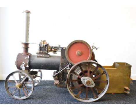
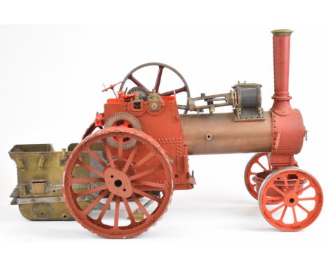
Los 1319
Approximately 1 inch scale live steam showman's or similar traction engine, with spirit fired boiler feeding a single cylinder with displacement lubricator and Stephenson's link reversing gear, controlled from a quadrant on the footplate beside the regulator and gear lever, the boiler having safety valve, water level gauge glass and fed by an eccentric driven pump. With solid bronze flywheel, canopy supported on twisted brass columns and working worm and chain steering, overall length 41cm, believed built by Harry Frost of Chapeltown near Sheffield 1904-1973
Los 467
Measuring instruments, to include a Velocity in Feet meter by the Cambridge Scientific Instrument Co., no. 8539, in leather case; a chemist's scale with two sets of cased weights; assorted lenses etc. together with a cased monocular microscope by C. Reichert, Wien Condition Report:Available upon request
Los 403
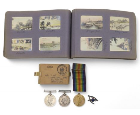
A WW1 medal pair awarded to S-25700 Pte. D.T. Laing, Royal Highlanders, a WW2 War Medal, a medal issue packet addressed to Mrs. J.W.F. Laing of 9 Keppleshill Road, Aberdeen and a silver and enamel RAF wishbone sweetheart brooch; together with an album of early-20th century small-scale colour photographic views mainly of India Condition Report:Available upon request
Los 21
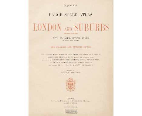
Bacon (G. W. publisher). Bacon's Large Scale Atlas of London and Suburbs (Revised Edition) with an Alphabetical Index, circa 1910, title page and contents list, 26 double-page and folding social, county, geographic and industrial maps and a 34-sheet map of Greater London, map of central London torn with loss to the lower left corner, first page of the index list and the map of the London Postal Districts with long repaired closed tear, very slight spotting, endpapers and pastedowns with some staining, publisher's half morocco gilt, stained, frayed and worn, folioQTY: (1)
![British Isles. Jansson (Jan & Hondius Henricus), Magnae Britanniae et Hiberniae Tabula, [1631 or later], hand-coloured en](https://cdn.globalauctionplatform.com/f54f2524-23c5-4fce-851e-b2ab00b37c36/6ab4563a-95d1-4d46-ba91-b2ae00f7f222/468x382.jpg)
Los 74
British Isles. Jansson (Jan & Hondius Henricus), Magnae Britanniae et Hiberniae Tabula, [1631 or later], hand-coloured engraved map, inset map of the Orkney Islands, decorative cartouche and mileage scale, slight creasing, several repaired marginal closed tears, central fold strengthened and repaired on verso, some additional professional repairs to the verso, 380 x 510 mm, Dutch text on versoQTY: (1)NOTE:Shirley, Early Printed Maps of the British Isles, 1477-1650, 435.
Los 89
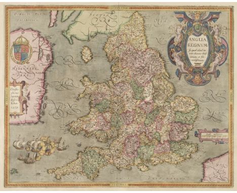
England & Wales. Ortelius (Abraham & Saxton Christopher), Anglia Regnum si quod aliud in toto Oceano ditissimum et florentissimum, Jan Baptist Vrients, Antwerp: [1603], decorative map engraved by Pieter Van den Keere, early hand-colouring and some later enhancement, large decorative cartouche and strapwork mileage scale, additional strapwork cartouche paying tribute to Christopher Saxton and a large maritime vignette commemorating the attack of the Spanish Armada to lower-left, large margins, 390 x 485 mm, Latin text on versoQTY: (1)NOTE:Shirley, Early Printed Maps of the British Isles 1477 - 1650, 258. Marcel Van den Broecke, Ortelius Atlas Maps, 20.
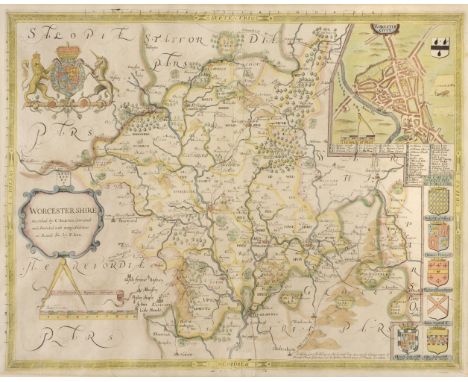
Los 155
Worcestershire. Saxton (Christopher & Lea Philip), Worcester Shire Described by C. Saxton Corrected and Amended with many Additions as Roads &c. by P. Lea, Sold by George Willdey at the Great Toy Spectacle..., circa 1720, hand-coloured engraved map, inset town plan of Worcester, strapwork cartouche and mileage scale, large margins, slight mount staining, marginal closed tears, repaired on verso, backed with tissue paper, 375 x 495 mmQTY: (1)
Los 100
Huntingdonshire. Gordon (William), An Accurate Map of the County of Huntingdon Actually Surveyed after a new Method in the Years 1730 & 1731, large scale map, engraved by Emanuel Bowen, with contemporary outline colouring on six sheets, not conjoined, oval cartouche, compass rose, large allegorical dedication cartouche to William Montague Duke and Earl of Manchester and an inset list of 'Index Villaris', stained and creased and each sheet is heavily frayed and torn with some loss, repaired with tape on verso, each sheet is approximately 490 x 580 mmQTY: (1)NOTE:One of the earliest and rarest large-scale county surveys, but sadly in poor condition. Only two institutional copies found (Cambridge University and the British Library).
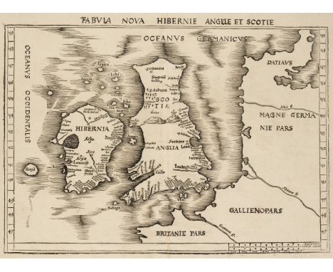
Los 78
British Isles. Waldseemuller (Martin), Tabula Nova Hibernie Anglie et Scotie, Strasbourg: 1513, uncoloured woodblock map on laid, large margins, central fold strengthened on verso, slight dust soiling, 380 x 520 mmQTY: (1)NOTE:Shirley, Early Printed Maps of the British Isles, 11. A scarce early map often described as the first 'modern map of the British Isles'. Published in Ptolemy's 'Geographia', it is the first map not reliant on Ptolemaic geography; instead, it used entirely contemporary sources. It was also the first map of the British Isles to include a mileage scale with a scale of (Italian) miles to the lower right. Note the mythical island of Brazil off the west coast of Ireland.
![* Scotland. Speed (John), The Kingdome of Scotland, 1st edition, John Sudbury & George Humble, [1611], uncoloured engrave](https://cdn.globalauctionplatform.com/f54f2524-23c5-4fce-851e-b2ab00b37c36/136292e1-e78b-4cea-82da-b2ae00f809e3/468x382.jpg)
Los 134
* Scotland. Speed (John), The Kingdome of Scotland, 1st edition, John Sudbury & George Humble, [1611], uncoloured engraved map, inset map of the Isles of Orkney, four portrait vignettes of James I (the Sixth of Scotland), Queen Anne, and their sons, Henry Prince of Wales & Ireland and Charles Duke of York and Albany, strapwork cartouche and mileage scale, old folds, crude tape repair to upper central fold and closed tear to lower central fold, a few repaired closed tears to margins, left and right margins trimmed to printed area, 385 x 515 mm, English text on verso, framed and double-glazed QTY: (1)
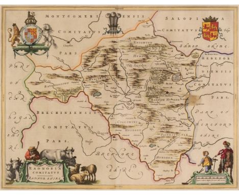
Los 151
* Wales. A Collection of Five Maps, 17th century, including Blaeu (Johannes). Radnoria Comitatyus, Radnor Shire, Amsterdam: circa 1645, engraved map with contemporary outline colouring, decorative cartouche and mileage scale, 380 x 490 mm, mounted, framed and glazed, together with Saxton (Christopher & Kip W.). Radnor Comitatus quem Silvres olim Incoluerunt, Brecknoc Comitatus pars olim Silvrum & Merionith Comitatus olim pars Ordovicum [1607 - 37], three hand-coloured engraved maps, each with a strapwork cartouche and mileage scale, Merioneth with a small rust hole affecting the printed image, each approximately 265 x 320 mm, mounted, framed and glazed, plus Ogilby (John). The Continuation of the Road from Chester to Cardiff com. Glamorgan, circa 1690, hand-coloured engraved strip road map, three pin holes affecting the printed image, 340 x 430 mm, mounted, framed and glazedQTY: (5)
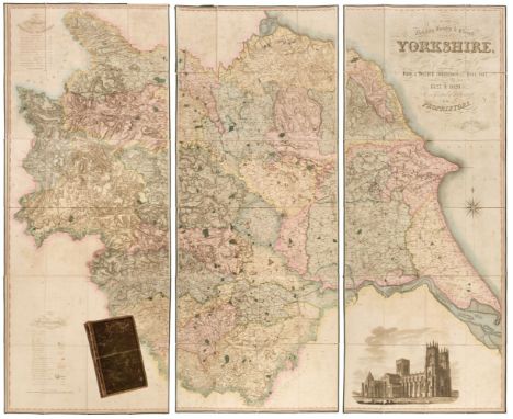
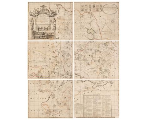
Los 165
Yorkshire. Teesdale (Henry & Stocking C.), To the Nobility, Gentry & Clergy of Yorkshire, this map of the county constructed from a survey commenced in the year 1817 & corrected in the years 1827 & 1828 is respectfully dedicated by the proprietors, April 21st, 1818, Teesdale & Co. and C. Stocking, April 21, 1828, large scale engraved map with contemporary hand colouring, sectionalised and laid on linen on three sheets, calligraphic title, compass rose, table of explanation and a table of the altitudes of the principal mountains and an uncoloured engraved vignette of the North West View of York Cathedral, some offsetting from the title, some staining and spotting, marbled endpapers, edged in green silk, overall size 1840 x 2230 mm, contained in a contemporary blind-stamped gilt morocco book box, worn, bruised and rubbedQTY: (1)
Los 68
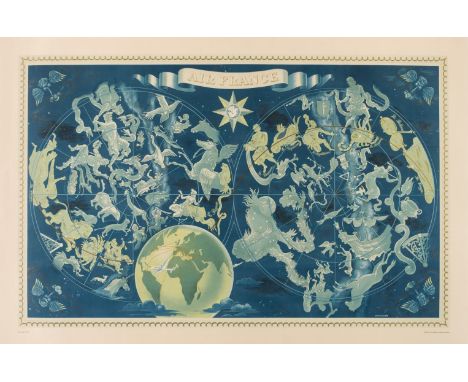
Boucher (Lucien, 1889-1971). Air France, Double-Hemisphere Celestial Map, printed by Perceval, Paris: circa 1950, colour lithographic map of the heavens and the zodiacal constellations, printed in gold, turquoise and blue, wind heads in each corner, small globe to lower centre showing Air France routes around the world and in the upper cusp is a circular image of a hippocampus set within a compass rose, large margins, 620 x 965 mm, laid on later linenQTY: (1)NOTE:The celestial companion piece to Boucher's 1950 double-hemisphere terrestrial map. These large-scale posters proved very popular and were issued in several editions throughout the early 1950s. This example is referenced as "10 - 1950."Louis Boucher designed and produced posters for Air France for nearly thirty years and this clever design manages to give the suggestion of a blend of fantasy and reality, and at the same time provides the viewer with a suggestion of the experience they will have if they choose to fly with Air France. It is designed to capture the imagination and at the same time provides a strong brand message. In an almost surrealistic manner, Boucher has managed to illustrate the constellations as obtainable and encourages us to see the aeroplane as not just the master of the sky, but of the whole universe, connecting the passenger not merely to earthly destinations, but to the stars themselves.
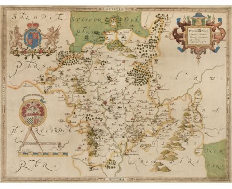
Los 158
* Worcestershire. Taylor (Isaac), To The Right Honourable Earl of Coventry, Lord Lieutenant & Custos Rotulorum of this County...., This Map of the County of Worcester is most Humbly Dedicated by their Obedient and most Humble Servant, Isaac Taylor, Ross-on-Wye, 1772, large scale engraved map with contemporary outline colouring and some later enhancement, printed on four conjoined sheets, decorative cartouche and mileage scale, compass rose, table of explanation set within a floriate border and a 'list of places taken from the Land Tax book', slight staining, the map appears to have been laid on card, 1030 x 1015 mm, framed and glazedQTY: (1)NOTE:A rare example of one of Isaac Taylor's fine large-scale county maps.
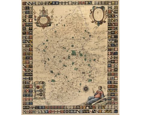
Los 142
Staffordshire. Plot (Robert). This Map of Staffordshire newly delineated after a new manner with all imaginable submission is humbly dedicated, published 1686, hand-coloured map engraved by Joseph Browne, trimmed to printed area and laid on old paper, 3 ornate cartouches and allegorical mileage scale, borders decorated with 233 heraldic shields, 630 x 530 mm, framed and glazed QTY: (1)
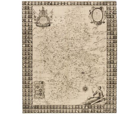
Los 141
Staffordshire. Plot (Robert). This Map of Staffordshire newly delineated after a new manner with all imaginable submission is humbly dedicated, circa 1686, uncoloured map, engraved by Joseph Browne, ornate cartouche and allegorical mileage scale, the borders decorated with 233 heraldic shields, old folds with very slight browning, folds strengthened and repaired on verso, 630 x 540 mmQTY: (1)
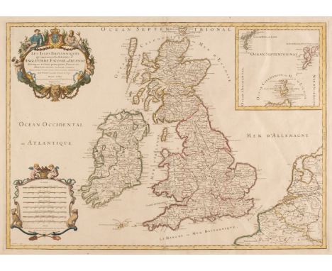
Los 72
British Isles. Jaillot (Hubert), Les Isles Britanniques qui contiennent les Royaumes d' Angleterre, Escosse et Irlande..., Paris: circa 1695, hand coloured engraved map, inset map of the Shetland and Faroe Islands, decorative cartouche and mileage scale, 465 x 650 mm, together with De L'Isle (Guillaume). Les Isles Britanniques ou sont le Rme. d'Angleterre tiré de Sped celut d'Ecosse tiré de Th. Pont &c. et celut d'Irlande tiré de Petti..., Paris, 1772, engraved map with contemporary outline colouring and some later enhancement, large cartouche and mileage scale, 475 x 620 mm, with De Fer (Nicolas). Les Isles Britanniques ou se Trouvent Les Royaumes D'Angleterre, D'Ecosse et D'Irlande..., Paris, 1706, hand-coloured engraved map, large decorative cartouche, some creasing, slight dust soiling, 460 x 485 mmQTY: (3)
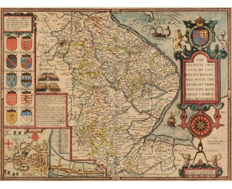
Los 109
* Lincolnshire. Speed (John), The Countie and Citie of Lyncolne Described, with the Armes of them that have bene Earles thereof since the Conquest, 1st edition, [1611], hand-coloured engraved map, inset town plan of Lincoln, large strapwork cartouche, compass rose and mileage scale, one small rust hole, slight staining, central fold strengthened and repaired on verso, 385 x 505 mm, mounted, framed and double-glazed, English text on versoQTY: (1)
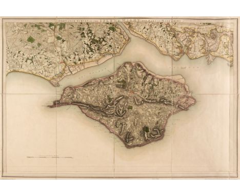
Los 104
Isle of Wight. Baker (Benjamin), Ordnance Survey of the Isle of Wight and Part of Hampshire, Tower of London: Colonel Mudge, 1st June 1810, large engraved map on a scale of one inch to the mile, contemporary outline colouring, sectionalised and laid on linen, slight offsetting and dust soiling, 630 x 920 mm, together with Walker (J. & C.). England South Coast Dunnose to the Needles including Spithead, Surveyed by Captn. Sheringham R. N. published at the Hydrographic Office of the Admiralty, Sept 1st 1852, large engraved hand-coloured sea chart, inset map of Southampton Water, numerous horizon profiles, old folds, slight dust soiling and creasing, 645 x 970 mmQTY: (2)
Los 70
British Isles. A collection of eleven maps, 18th - 20th century, engraved and lithographic county and regional maps, including Covens (Johannes & Mortier Pierre). Guilielmo III D. G. Angliae, Scotiae, Franciae et Hiberniae Regni..., circa 1730, engraved triangular mileage scale with contemporary hand-colouring, central fold strengthened on verso, lower right corner torn with no loss to the printed surface, skillfully repaired, 505 x 605 mm, together with Taylor (A. E.). Esso Pictorial Plan of the West Country (2 copies) & Esso Pictorial Plan of the Roads of the South Coast, & Esso Pictorial Plan of the Principal Islands of Southern Britain (2 copies), circa 1932, five colour lithographic maps, various sizes, good condition, with MacLure and Co. (lithographers). Our National Defences, Birds-Eye View Showing the Chief Points of Defence against Invasion, Supplement to the Graphic, August 25th 1888, colour lithographic map with a key plate to the lower right, 395 x 575 mm, explanatory text to the verso, plus three pictorial chromolithographic 'map postcards' of regional maps of the British Isles, each approximately 90 x 140 mm, and Pasquali (G. V.). La Gran Brettagna per L'Atlante di Mr. Le - Sage, Venice, 1827, engraved map with contemporary wash colouring, 370 x 480 mm, and an 18th-century uncoloured engraved view of Edinburgh, originally published in 'Millar's New Complete Universal System of Geography', 205 x 305 mmQTY: (12)
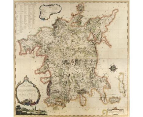
Los 156
Worcestershire. Saxton (Christopher), Wigorniensis Comitatus Sabrinae Fluminis Amoenitate ni signis descriptio An Dm 1577, [1579, but slightly later], engraved map with contemporary wash colouring, large strapwork cartouche and mileage scale, with the heraldic crest of Elizabeth I and the arms of Thomas Seckford, good margins, slight mount staining, 380 x 485 mmQTY: (1)NOTE:The first printed map of Worcestershire. The watermark shows a kneeling saint holding a cross, which is considered to be indicative of the 4th state from circa 1600.
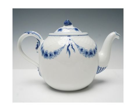
Los 364
A finely crafted Bing & Grondahl porcelain teapot from the Empire collection, showcasing a timeless blue and white motif. This exquisite piece features delicate hand-painted garlands and ribbons, accentuated by a textured fish-scale pattern along the upper portion. The gracefully curved spout and handle complement its refined silhouette, while the lid is crowned with a charming snail-shaped finial. Marked on the base with the Bing & Grondahl backstamp and model number 656. A sophisticated addition to any fine porcelain collection.Issued: 20th centuryDimensions: 6.5"HCondition: Age related wear.
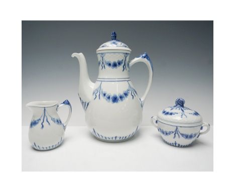
Los 374
A refined Bing & Grondahl 3-piece coffee set in the classic Empire pattern, featuring a coffee pot with lid, a creamer, and a sugar bowl with lid. Crafted from fine Danish porcelain, this set showcases the elegant blue-on-white design inspired by neoclassical motifs, with intricate garland detailing and a delicate scale-like texture. The Empire pattern, a hallmark of B&G’s craftsmanship, embodies timeless sophistication. Each piece bears the Bing & Grondahl hallmark on the base. A beautiful addition to any collection or table setting. Largest item measures 9.5"H.Issued: 20th centuryDimensions: See DescriptionCondition: Age related wear.
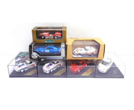
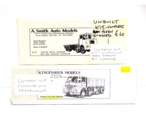
Los 83
TWO 1/48 SCALE WHITE METAL LORRY KITS comprising a Kingfisher Models Foden S21 8x4 Tipper, unmade; and an A. Smith Auto Models No.BR16, Albion HD57L Flatbed, started but unfinished. Condition Report : Both unchecked but believed to be complete. Condition reports are offered as a guide only and we highly recommend inspecting (where possible) any lot to satisfy yourself as to its condition.
-
215359 Los(e)/Seite